 W
WAmundsen Coast is that portion of the coast to the south of the Ross Ice Shelf lying between Morris Peak, on the east side of Liv Glacier, and the west side of the Scott Glacier. Named by New Zealand Antarctic Place-Names Committee in 1961 for Captain Roald Amundsen, the Norwegian explorer who led his own expedition in 1910–12 to the Antarctic. Setting up a base at Framheim at the edge of the Ross Ice Shelf, he sledged southward across the shelf and discovered a route up the Axel Heiberg Glacier along this coast to reach the polar plateau. He was the first to reach the South Pole, December 14, 1911.
 W
WBig Razorback Island is the southeasternmost of the Dellbridge Islands, lying in Erebus Bay off the west side of Ross Island. It was discovered and named by the British National Antarctic Expedition, 1901–04, under Robert Falcon Scott. The name reflects the supposed similarity of the shape of the island to a large Razorback.
 W
WBlack Island, in the Ross Archipelago, is immediately west of White Island. It was first named by the Discovery Expedition (1901–04) because of its lack of snow. The island's northernmost point is named Cape Hodgson, commemorating Thomas Vere Hodgson.
 W
WBrockton Station was an American research (weather) station in Antarctica. It was built by the Seabees and operated by the US Navy during the summer months from October 1965 to February 1972. The station was located 300 miles southeast of McMurdo Station, near the center of the Ross Ice Shelf.
 W
WBrosnahan Island is an island 2 kilometres (1 nmi) long, rising above the western part of the Ross Ice Shelf 20 kilometres (11 nmi) northeast of Cape Murray. It was mapped by the United States Geological Survey from tellurometer surveys and Navy air photos, 1959–63, and named by the Advisory Committee on Antarctic Names for Commander James J. Brosnahan, U.S. Navy, commander of the McMurdo Station winter party, 1961.
WCape Colbeck is a prominent ice-covered cape which forms the northwestern extremity of the Edward VII Peninsula and Marie Byrd Land in Antarctica. It was discovered in January 1902 by the British National Antarctic Expedition and named for Captain William Colbeck, Royal Naval Reserve, who commanded Robert Scott's relief ship, the Morning.
WChandler Island is an island 7 kilometres (4 nmi) long which is the southernmost of the ice-covered White Islands, located at the head of Sulzberger Bay. It was mapped by the United States Geological Survey from surveys and from U.S. Navy air photos, 1959–65, and named by the Advisory Committee on Antarctic Names for Alan Chandler, electrical engineer with the Byrd Station winter party in 1969.
WCrary Bank is a northeast trending undersea bank of the central Ross continental shelf. It was named, in association with Crary Ice Rise, for A.P. Crary, an American geophysicist, the name being approved by the Advisory Committee for Undersea Features in June 1988.
 W
WThe Dellbridge Islands are a group of four islands lying in the Antarctic, just south of Cape Evans and Ross Island.
 W
WEady Ice Piedmont is the ice piedmont lying south of Mount Discovery and Minna Bluff, merging at the south side with the Ross Ice Shelf, Antarctica. It was mapped by the United States Geological Survey from ground surveys and Navy air photos, and was named by the Advisory Committee on Antarctic Names in 1963 for Captain Jack A. Eady, U.S. Navy, Chief of Staff to the Commander, U.S. Naval Support Force, Antarctica, from July 1959 to April 1962.
 W
WKing Edward VII Land or King Edward VII Peninsula is a large, ice-covered peninsula which forms the northwestern extremity of Marie Byrd Land in Antarctica. The peninsula projects into the Ross Sea between Sulzberger Bay and the northeast corner of the Ross Ice Shelf, and forms part of the Ross Dependency. Edward VII Peninsula is defined by the Ross Ice Shelf on the southwest, Okuma Bay on the west, and to the east by Sulzberger Bay and the Saunders Coast, all essentially on the Ross Sea / Southern Ocean in Antarctica. The northwest extremity of the peninsula is Cape Colbeck. Edward VII Peninsula is located at 77°40′S 155°00′W.
WFisher Island is an ice-covered island 13 kilometres (7 nmi) long, lying just north of Edward VII Peninsula where it marks the Western side of the entrance to Sulzberger Bay. Mapped from surveys by the USGS and U.S. Navy air photos (1959–65). Named in 1966 by US-ACAN for Wayne Fisher of the United States Department of State.
 W
WThe Gould Coast is that portion of the coast of Antarctica along the eastern margin of the Ross Ice Shelf at Amundsen Coast between the west side of Scott Glacier and the south end of the Siple Coast. It was named by the New Zealand Antarctic Place-Names Committee in 1961 for Laurence M. Gould, a geologist who was second-in-command of the Byrd Antarctic Expedition, 1928–30. Gould led the Geological Party which in 1929 mapped 175 miles (280 km) of this coast. While president of Carleton College, Northfield, Minnesota, he was appointed Chairman of the U.S. National Committee for the International Geophysical Year and took a prominent part in planning the United States research program for Antarctica.
 W
WHaggits Pillar is a stack 203 feet (62 m) high in the South Pacific Ocean at the northwestern edge of the Ross Sea, lying 250 metres (270 yd) west of Scott Island and some 500 kilometres (310 mi) north-northeast of Cape Adare, Victoria Land, Antarctica. It measures 50 metres (55 yd) in diameter, yielding an area of less than 0.2 hectares.
 W
WThe Hillary Coast is that portion of the coast of Antarctica along the western margin of the Ross Ice Shelf between Minna Bluff and Cape Selborne. It was named by the New Zealand Antarctic Place-Names Committee in 1961 for Sir Edmund Hillary, the leader of the New Zealand Party of the Commonwealth Trans-Antarctic Expedition, 1956–58. Various New Zealand parties carried out detailed surveys of portions of this coast and pioneered routes up Skelton Glacier and Darwin Glacier to the polar plateau.
 W
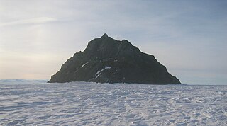
WInaccessible Island is a small rocky island, the northernmost of the Dellbridge Islands, lying 2 kilometres (1 nmi) southwest of Cape Evans, Ross Island, Antarctica. It is the most imposing of the group as it is nearly always bare of snow and rises to 95 meters (310 ft). The island was discovered by the British National Antarctic Expedition (1901–04) under Robert Falcon Scott and so named because of the difficulty in reaching it.
 W
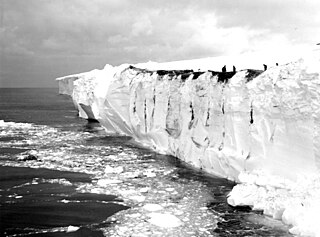
WKainan Bay is an iceport which indents the front of the Ross Ice Shelf about 37 nautical miles (70 km) northeast of the northwestern end of Roosevelt Island, Antarctica. It was discovered in January 1902 by the British National Antarctic Expedition under Robert Falcon Scott. It was named by the Japanese Antarctic Expedition under Lieutenant Shirase Nobu which, in January 1912, effected a landing on the ice shelf here from the ship Kainan Maru. Little America V, the main base of U.S. Navy Operation Deep Freeze, 1955–56, was established at this site in late December 1955.
 W
WKizer Island is an ice-covered island about 30 kilometres (15 nmi) long, lying 20 kilometres (10 nmi) southwest of Cronenwett Island at the west end of the Sulzberger Ice Shelf off Saunders Coast, Marie Byrd Land, Antarctica. It was mapped from surveys by the United States Geological Survey (USGS) and from U.S. Navy air photos (1959–65), and was named for Lieutenant T.L. Kizer, U.S. Navy, a helicopter pilot on the USS Glacier (AGB-4) who sighted the island from the air on January 26, 1962.
WLittle Razorback Island is the smallest and easternmost of the Dellbridge Islands, lying in Erebus Bay off the west side of Ross Island, Antarctica. It was discovered by the British National Antarctic Expedition under Robert Falcon Scott, 1901–04, and so named because of its size and similarity to nearby Big Razorback Island.
WMickle Island is a very small island 2 kilometres (1 nmi) southeast of Flagstaff Point, close off the west side of Ross Island, Antarctica. It was charted and so named by the British Antarctic Expedition, 1907–09, led by Ernest Shackleton. The name appears to be capricious or whimsical, "mickle" meaning "great."
 W
WNødtvedt Nunataks is an isolated nunataks standing in mid-stream of the Amundsen Glacier, rising 7 nautical miles (13 km) east-northeast of Mount Bjaaland, Antarctica. Named by Advisory Committee on Antarctic Names (US-ACAN) for J. Nødtvedt, a member of the sea party of Amundsen's Norwegian expedition of 1910–12.
 W
WThe North-west White Island Antarctic Specially Protected Area comprises a 142 km2 area of coastal shelf ice on the north-west side of White Island in the Ross Archipelago of Antarctica.The site has been designated an Antarctic Specially Protected Area because it supports an unusual small breeding population of Weddell seals, which is not only the most southerly known, but which has also been physically isolated from other populations by the advance of the McMurdo and Ross ice shelves. The first seals in the area were recorded in 1958, since when the population has grown to 25–30. The seals use the open waters of McMurdo Sound but do not have the breathing capacity to reach the open ocean by swimming beneath the intervening 20 km of permanent shelf ice.
 W
WOkuma Bay is a bay located at 77° 50' S 158° 20' W on the Ross Ice Shelf of Antarctica at its juncture with Edward VII Peninsula.
WOlson Island is the largest and northernmost of the ice-covered White Islands, in southern Sulzberger Bay. The feature is rudely delineated on the map of the Byrd Antarctic Expedition, 1928–30, and is indicated as "low ice cliffs" that rise above the ice shelf in this part of the bay. It was mapped in detail by the United States Geological Survey (USGS) from surveys and U.S. Navy air photos, 1959–65. It was named for Michael L. Olson, United States Antarctic Research Program (USARP) ionospheric physicist at Byrd Station, winter party 1968, and a member of the Plateau Station summer party, 1968–69.
WRoss Archipelago is a name for that group of islands which, together with the ice shelf between them, forms the eastern and southern boundaries of McMurdo Sound in Antarctica. The most northerly is Beaufort Island, then comes Ross Island, the Dellbridge Islands, and Black Island and White Island. Frank Debenham's classic report, The Physiography of the Ross Archipelago, 1923, described "Brown Island" as a part of the group.
 W
WSaunders Coast is that portion of the coast of Marie Byrd Land between Cape Colbeck and Brennan Point, or between Shirase Coast in the west and Ruppert Coast in the east. It stretches from 158°01'W to 146°31'W. The portion west of 150°W is part of Ross Dependency, while the remaining area is unclaimed by any nation. This coast was explored from the air on December 5, 1929, by the Byrd Antarctic Expedition (1928–30) and was first mapped from aerial photographs obtained on that flight by Capt. Harold E. Saunders, USN, for whom the coast is named. The United States Geological Survey (USGS) completely mapped the coast from ground surveys and U.S. Navy air photos, 1959–65.
 W
WThe Scott Nunataks are a group of conspicuous nunataks lying about 18 km east of the Richter Glacier and forming the northern end of the Alexandra Mountains in King Edward VII Land, Antarctica.
WStrider Rock is a rock 1 nautical mile (1.9 km) northwest of Mount Nilsen in the Rockefeller Mountains of Edward VII Peninsula, Marie Byrd Land, West Antarctica.
WSulzberger Bay is a bay between Fisher Island and Vollmer Island, along the coast of King Edward VII Land. Discovered by the Byrd Antarctic Expedition on December 5, 1929, and named by Byrd for Arthur H. Sulzberger, publisher of The New York Times, a supporter of the Byrd expeditions in 1928–1930 and 1933–1935.
WThe Swinburne Ice Shelf, is an ice shelf just north of Edward VII Peninsula and the Alexandra Mountains in the southern part of Sulzberger Bay, Antarctica. The ice shelf is twenty miles (32 km) long and five miles (8 km) wide and extends from Fisher Island to White Islands. It was photographed from aircraft and mapped by the Byrd Antarctic Expedition (ByrdAE), 1928–30. Named by Advisory Committee on Antarctic Names (US-ACAN) for Captain H.W Swinburne, Jr., Deputy Commander and Chief of Staff, U.S. Naval Support Force, Antarctica, during Operation Deep Freeze 1970 and 1971.
WTent Island is one of the Dellbridge Islands in McMurdo Sound, Antarctica.
WVollmer Island is an ice-covered island 20 kilometres (11 nmi) long, lying along the edge of Sulzberger Ice Shelf, 13 kilometres (7 nmi) northwest of Cronenwett Island. It appears that this feature was first observed and roughly mapped from aerial photographs taken by the Byrd Antarctic Expedition, 1928–30. Named by Advisory Committee on Antarctic Names (US-ACAN) for Lieutenant T.H. Vollmer, U.S. Navy, engineering officer aboard USS Glacier along this coast, 1961–62.
 W
WWhite Island is an island in the Ross Archipelago of Antarctica. It is 28 km (15 nmi) long, protruding through the Ross Ice Shelf immediately east of Black Island. It was discovered by the Discovery Expedition (1901–04) and so named by them because of the mantle of snow which covers it. Some 142 km2 of shelf ice adjoining the north-west coast of the island has been designated an Antarctic Specially Protected Area because it supports an isolated small breeding population of Weddell seals.
WThe White Islands are a group of ice-covered islands extending north–south for about 19 kilometres (10 nmi). They lie at the east margin of Swinburne Ice Shelf and near the terminus of Butler Glacier in the south part of Sulzberger Bay. This feature is rudely delineated on the map of the Byrd Antarctic Expedition, 1928–30, as "low ice cliffs" that rise above the level of the ice shelf. The islands were mapped in detail by United States Geological Survey (USGS) from surveys and U.S. Navy air photos, 1959–65. The name was applied by Advisory Committee on Antarctic Names (US-ACAN) at the suggestion of Admiral R.E. Byrd. Named for Dr. Paul Dudley White, internationally renowned specialist on heart diseases, who was a consultant on medical matters in regard to U.S. Navy Operation Highjump, 1946–47, led by Byrd.