 W
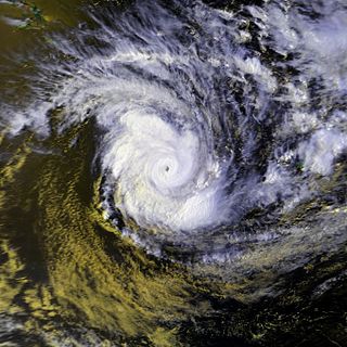
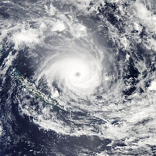
WSevere Tropical Cyclone Anne was one of the most intense tropical cyclones within the South Pacific basin during the 1980s. The cyclone was first noted on January 5, 1988 as a weak tropical depression to the northeast of Tuvalu, in conjunction with the future Typhoon Roy in the Northern Hemisphere. Over the next few days, the system gradually developed while moving southwestward. Once it became a tropical cyclone, it was named Anne on January 8. The next day, Anne rapidly intensified, becoming the fourth major tropical cyclone to affect Vanuatu within four years. On January 11, Anne peaked in intensity while it was equivalent to a Category 5 on the Saffir–Simpson hurricane wind scale, and a Category 4 on the Australian tropical cyclone intensity scale. After turning southward on January 12, Anne struck New Caledonia, becoming the strongest tropical cyclone to affect the French Overseas Territory. The system subsequently weakened as it started to interact with Tropical Cyclone Agi. Anne weakened into a depression and was last noted on January 14 to the south-east of New Caledonia.
 W
WSevere Tropical Cyclone Beni was an intense tropical cyclone that affected four countries, on its 18-day journey across the South Pacific Ocean during January and February 2003. The system originally developed during 19 January as a weak tropical disturbance within the monsoon trough, to the northeast of the Santa Cruz Islands. Over the next few days the system gradually developed further before it was classified as a tropical cyclone and named Beni during 24 January.
 W
WCyclone Bola was one of the costliest cyclones in the history of New Zealand, causing severe damage as an extratropical cyclone when it passed near the country in March 1988. It formed on February 24 to the north of Fiji, and tracking generally southwestward it reached hurricane-force winds near Vanuatu on February 28. The next day it generated peak wind velocities of 195 km/h (120 mph), though it quickly weakened as it accelerated southward. On March 4, Bola transitioned into an extratropical storm, passing to the north of the North Island of New Zealand on March 8. It weakened further and was absorbed by a stationary trough near the South Island on March 12.
 W
WSevere Tropical Cyclone Cook was the second named tropical cyclone of the 2016–17 South Pacific cyclone season.
 W
WSevere Tropical Cyclone Betsy impacted 8 island nations.
 W
WSevere Tropical Cyclone Donna was the strongest off-season tropical cyclone in the Southern Hemisphere during the month of May. The twenty-first tropical disturbance, third named storm, and second severe tropical cyclone of the annual cyclone season, Donna formed from an area of disturbed weather that was first monitored west-northwest of Fiji on 1 May 2017. The disturbance drifted eastward amid an increasingly favourable environment, and it was designated Tropical Depression 21F late on 2 May. Twelve hours later, it intensified into a Category 1 on the Australian tropical cyclone scale and was designated Tropical Cyclone Donna as the storm's motion shifted west and then south. After reaching its initial peak as a Category 4 cyclone early on 6 May, the effects of wind shear and upwelling caused the storm to weaken. However, it reintensified into a Category 5 cyclone on 8 May. Soon after, Donna entered a region of strong westerly flow and began to rapidly weaken. Continuing to accelerate in a southerly direction, Donna eventually weakened into a tropical low on 10 May. By 16 May, Donna's remnants had fully dissipated.
 W
WSevere Tropical Cyclone Drena was a powerful tropical cyclone that caused significant damage throughout New Zealand. A tropical depression formed on January 2, 1997. After crossing Vanuatu and emerging into the Coral Sea, the storm began to intensify, and by January 6, had attained peak intensity. After attaining peak intensity, Drena began to weaken. Cyclone Drena later brushed New Caledonia, bringing some damage. After transitioning into an extratropical cyclone on January 9, Drena brought impact to New Zealand. Damage totaled to $6.7 million and 3 people were killed. Roughly 140 people were evacuated after 44 homes were flooded. After the season, Drena was retired.
 W
WSevere Tropical Cyclone Eric was one of two tropical cyclones to affect the island nations of Vanuatu and Fiji within a week during January 1985. The precursor shallow depression developed within the monsoon trough during January 13, to the west of Espiritu Santo, Vanuatu. On January 16, the storm developed-hurricane-force winds and Eric began to undergo rapid deepening. While two different agencies differ on when and how strong Eric was at its peak, it was believed to have peak on January 17 while passing through the Fiji island group. Shortly after its peak, Eric began to weaken steadily, and by January 20, Severe Tropical Cyclone Eric had ceased to exist as a tropical cyclone. Cyclone Eric combined with another storm brought 25 fatalities. Eric caused $40 million worth of damage. A total of 299 farms were affected as well as the airport in Nadi. About 30,000 people were left homeless. Severe crop damage was also reported. Viti Levu sustained the worst effects from Cyclone Eric. During the aftermath of the storm, a number of first world countries distributed aid for victims of Eric.
 W
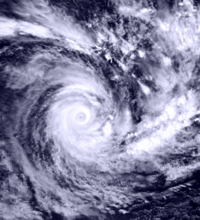
WSevere Tropical Cyclone Esau was the strongest tropical cyclone to affect New Caledonia on record. A shallow tropical depression developed within the monsoon trough during 24 February, about 370 km (230 mi) to the northeast of Port Vila, Vanuatu. Over the next day, the system gradually developed further as it moved towards the south-west under the influence of a northerly steering flow, before it passed over Pentecost Island in northern Vanuatu during 25 February. After passing over Pentecost the system continued to move towards the southwest and passed near the island of Malampa before the depression turned northwards and executed a small clockwise loop as it passed over the island of Espiritu Santo. The system was subsequently named Esau during 26 February, after it had developed into a tropical cyclone. Over the next couple of days, the system moved south-westwards towards Australia and away from the islands of Vanuatu. Esau subsequently executed a second clockwise loop during 28 February, before it peaked as a Category 4 tropical cyclone on both the Australian tropical cyclone intensity scale and the Saffir-Simpson hurricane wind scale. After it had peaked the system moved south-eastwards and threatened Southern Vanuatu, before turning southwards and threatening the French overseas territory of New Caledonia. Esau made landfall on the French territory during 4 March, as a category 3 severe tropical cyclone before degenerating into an extratropical cyclone during 5 March. The systems remnants made landfall on New Zealand's North Island during 8 March, before they were last noted during the next day over the South Pacific Ocean.
 W
WCyclone Fergus was a tropical cyclone, later becoming an extratropical cyclone, that affected islands in the south-west Pacific Ocean. It lasted from December 23, 1996, to January 1, 1997, and reached speeds of up to 165 kilometers per hour, or 90 miles per hour. In additions to its winds, the storm caused heavy rains and severe flooding, causing significant damage to property in some areas.
 W
WSevere Tropical Cyclone Fran was the third tropical cyclone within four weeks to impact Vanuatu in 1992. Fran formed on March 4 and then gradually intensified. Winds reached gale-force on March 5, and hurricane-force a few days later. Cyclone Fran reached the powerful Category 5 equivalent on the Saffir–Simpson Hurricane Scale near Vanuatu. The storm weakened somewhat due to land interaction, but briefly re-intensified after moving away from land. Fran gradually weakened over the next several days over less favorable conditions. Meanwhile, the storm passed north of New Caledonia. Eventually, as a Category 2 system on the Australian scale, Fran made landfall on Queensland during March 16. Severe Tropical Cyclone Fran turned towards the southeast and eventually headed back out to sea. The system dissipated the next day. On Efate, over 130 houses lost roofs. Along Queensland, two rivers sustained major flooding, but no deaths were attributed to this cyclone. Total damage from the system was AU$8–10 million. Moderate damage was also reported in Fiji. In New Caledonia, the storm brought flooding and landslides.
 W
WSevere Tropical Cyclone Funa was the second strongest tropical cyclone during the 2007–08 South Pacific cyclone season, causing heavy flood and wind damage to areas of Vanuatu. The third tropical cyclone and second severe tropical cyclone of the season to form to the west of 160°E, Funa formed from an area of disturbed weather within the monsoon trough northeast of Vanuatu on January 16, 2008. Steadily intensifying as it moved to the east and subsequently south, Funa reached peak intensity with 10-minute sustained winds of 175 km/h (110 mph). However, the cyclone encountered unfavorable conditions as it progressed further south, before transitioning into an extratropical cyclone on January 21.
 W
WSevere Tropical Cyclone Gita was the most intense tropical cyclone to impact Tonga since reliable records began. The second named storm and first major tropical cyclone of the 2017–18 South Pacific cyclone season, Gita originated from a monsoon trough that was active in the South Pacific in early February 2018. First classified as a tropical disturbance on 3 February, the nascent system meandered near Vanuatu for several days with little development. After acquiring a steady east trajectory near Fiji, it organized into a Category 1 tropical cyclone on 9 February near Samoa. Arcing south in a clockwise turn, the system rapidly intensified, and became a severe tropical cyclone on 10 February near Niue.
 W
WSevere Tropical Cyclone Harold was a very powerful tropical cyclone which caused widespread destruction in the Solomon Islands, Vanuatu, Fiji, and Tonga during April 2020. iI was the first Category 5 tropical cyclone in 2020. The seventh named storm of the 2019–20 Australian region cyclone season, eighth named storm, and fourth severe tropical cyclone of the 2019–20 South Pacific cyclone season, Harold was first noted as a developing tropical low within a trough of low pressure during April 1, while it was located to the east of Papua New Guinea. Over the next day, the system moved south-eastwards over the Solomon Sea, before it was classified as a tropical cyclone and named Harold by the Australian Bureau of Meteorology. The system moved into the Fiji Meteorological Service's area of responsibility on April 2 and began to explosively intensify by April 3, reaching Category 4 status by April 4 on both scales. The next day, it further strengthened into a Category 5 severe tropical cyclone, the highest rating on the Australian scale. It made landfall on Espiritu Santo on April 6. Shortly afterward, the Joint Typhoon Warning Center (JTWC) upgraded it to a Category 5-equivalent cyclone on the Saffir–Simpson scale. It maintained this status for only six hours before being downgraded back to Category 4.
 W
WSevere Tropical Cyclone Hola was a strong tropical cyclone which affected Vanuatu, New Caledonia and New Zealand. Forming as a broad tropical disturbance on 5 March, the system slowly consolidated over the next few days before developing into a tropical cyclone on 6 March. Afterwards, a pinhole eye began to emerge and rapid intensification ensued.
 W
WSevere Tropical Cyclone Ivy was a tropical cyclone that affected about 25% of the population of Vanuatu in February 2004. It was first classified as a tropical disturbance on February 21 between Vanuatu and Fiji. The system tracked northwestward, gradually organizing and intensifying. After attaining tropical storm status on February 23, Ivy strengthened more quickly as it turned southwestward toward Vanuatu. It attained peak winds of 165 km/h (105 mph) while moving over Vanuatu, making it an intense Category 4 cyclone on the Australian Region Tropical Cyclone Intensity Scale. By the time it passed through Vanuatu, Ivy had turned southeastward, and it gradually weakened while accelerating. After becoming extratropical on February 28, it passed just east of New Zealand and eventually dissipated on March 2.
 W
WSevere Tropical Cyclone Jasmine was a powerful and long-lived annular tropical cyclone that affected several countries, particularly Vanuatu and Tonga, over a 16-day span in February 2012. The system was the second cyclone and the only severe tropical cyclone of the relatively quiet 2011–12 South Pacific cyclone season. Cyclone Jasmine developed from an area of disturbed weather on 1 February in the Gulf of Carpentaria. Initially, the storm moved towards the east and across the Cape York Peninsula. As it moved across the South Pacific, earlier existing wind shear conditions lessened, and Jasmine began to strengthen at a faster rate. Steadily intensifying, Jasmine reached peak intensity on 8 February as a Category 4 equivalent on the Saffir–Simpson Hurricane Scale, while beginning to show annular characteristics.
 W
WSevere Tropical Cyclone Kina was a significant tropical cyclone which became the second-costliest storm to ever hit Fiji, only after Cyclone Winston of 2016. Total losses from Kina are estimated to be near $F170 million ($US110 million). The system was first noted as a tropical depression, to the east of the Solomon Islands on December 23. Over the next few days the system moved south-eastwards and gradually developed further, before it was named Kina, after it had developed into a tropical cyclone during December 26.
 W
WCyclone Lusi was the second severe tropical cyclone of the 2013–14 season and affected Fiji, Vanuatu and New Zealand.
 W
WSevere Tropical Cyclone Nigel was the second of two tropical cyclones to affect Northern Vanuatu and the Fijian islands during January 1985. The system was first noted as an ill-defined low-pressure area ("low") located within the intertropical convergence zone near the Cape York Peninsula. Over the next few days the low moved eastwards and increased in strength; it was named Nigel on January 16 as it developed into a tropical cyclone.
 W
WSevere Tropical Cyclone Pam was the second most intense tropical cyclone of the south Pacific Ocean in terms of sustained winds and is regarded as one of the worst natural disasters in the history of Vanuatu. A total of 15–16 people lost their lives either directly or indirectly as a result of Pam with many others injured. The storm's impacts were also felt, albeit to a lesser extent, to other islands in the South Pacific, most notably the Solomon Islands, Tuvalu, and New Zealand. Pam is the third most intense storm of the South Pacific Ocean according to pressure, after Winston of 2016 and Zoe of 2002. It is also the second most intense tropical cyclone in 2015, only behind Hurricane Patricia. In addition, Pam is tied with Orson, Monica, Marcus and Fantala for having the second strongest ten-minute maximum sustained winds in the Southern Hemisphere. Thousands of homes, schools and buildings were damaged or destroyed, with an estimated 3,300 people displaced as a result.
 W
WSevere Tropical Cyclone Paula was a tropical cyclone which caused extensive damage to areas of Vanuatu. The cyclone was the second cyclone and only severe tropical cyclone of the relatively inactive 2000–01 South Pacific cyclone season. Cyclone Paula developed from an area of disturbed weather embedded within a monsoon trough on February 25, 2001, near Vanuatu. Situated in an area of favorable conditions, Paula steadily intensified as it moved in a general direction towards the southeast. On March 1, Paula reached peak intensity with winds of 175 km/h (109 mph), sustained for ten minutes. However, the cyclone began to accelerate further to the southeast into more unfavorable conditions. As a result, Paula quickly weakened, and thus degenerated into an extratropical cyclone on March 4.
 W
WSevere Tropical Cyclone Prema was among the worst tropical cyclones to hit Vanuatu since 1987's Cyclone Uma. The twenty-third storm of the season, Prema formed early on 26 March 1993 as a weak tropical depression.
 W
WSevere Tropical Cyclone Rewa affected six countries and caused 22 deaths on its 28-day journey across the South Pacific Ocean in December 1993 and January 1994. Cyclone Rewa developed from a tropical disturbance on 28 December south of Nauru. After forming, Rewa moved southwest through the Solomon Islands, crossing the 160th meridian east from the South Pacific basin into the Australian region. The cyclone began to strengthen steadily and turned southward, paralleling the eastern Australian coast through 31 December. Rewa reached its initial peak intensity as a Category 4 tropical cyclone on 2 January. It maintained this intensity for about 12 hours before an increase in wind shear induced its weakening by 3 January. The cyclone turned southeastward and moved back into the South Pacific basin on 4 January, before it passed over New Caledonia between 5–6 January. After affecting New Caledonia, Rewa weakened to a tropical depression and turned northwestward before re-entering the Australian basin on 10 January.
 W
WTropical Cyclone Sose was a moderate storm system that chiefly impacted the island nation of Vanuatu in early April 2001. The developing cyclone was first detected on April 3, while situated well to the northeast of Vanuatu. As atmospheric conditions became more conducive to intensification, the disturbance gradually consolidated as it drifted toward the west-southwest. After receiving the name Sose on April 5, the cyclone was driven southeastward, passing just west of Espiritu Santo and neighboring islands. Although it never made landfall, Sose was particularly expansive, producing a wide area of gale-force winds. The cyclone peaked in strength between April 7 and 8 with maximum 10-minute sustained winds of 110 km/h (70 mph) and 1-minute sustained winds of 130 km/h (80 mph), placing it at Category 2 intensity on the Australian tropical cyclone intensity scale. Ultimately, stronger wind shear and an increasingly hostile upper-air pattern took their toll on the cyclone as it progressed due south; Sose lost tropical characteristics to the northeast of Norfolk Island by April 12. The extratropical remnants of Sose continued into the Tasman Sea.
 W
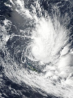
WSevere Tropical Cyclone Susan was one of the most intense tropical cyclones on record within the South Pacific basin, which was first noted on December 20, 1997, as a weak tropical disturbance located to the north of American Samoa. Over the next 12 days, the disturbance remained weak while it gradually moved towards the southwest before it started to rapidly develop on January 2, 1998 while it was located near the Fijian dependency of Rotuma. The disturbance was declared a tropical cyclone later that day, but was not named Susan until the next day, after it had intensified into a category 2 tropical cyclone on the Australian Scale. Over the next few days, Susan moved towards the southwest and continued to intensify before it reached its peak intensity as a category five tropical cyclone during January 5 while it was located about 400 km (250 mi) to the northwest of Vanuatu's capital city Port Vila.
 W
WSevere Tropical Cyclone Tia was the first of six tropical cyclones to affect Vanuatu during the 1991–92 South Pacific cyclone season. The system was first noted within the South Pacific convergence zone as a small tropical depression on November 13, to the northeast of the Solomon Islands. Over the next few days the system gradually developed further within an area of light winds in the upper troposphere, before it was named Tia early on November 16. Later that day due to a developing northerly steering current, the system slowed and undertook a small anticlockwise loop before starting to move towards the southwest and rapidly intensify. After rapidly intensifying throughout November 16 and 17, Tia passed within 55 km (35 mi) of the Solomon Island: Anuta at around 1800 UTC on November 17, before passing near Tikopia Island six hours later. As Tia moved near Tikopia, the system reached its peak intensity as a category 3 severe tropical cyclone, with 10‑minute sustained windspeeds of 140 km/h (85 mph).
 W
WSevere Tropical Cyclone Tino was a tropical cyclone which itself and an associated convergence zone caused significant damage across ten island nations in the South Pacific Ocean during January 2020. First noted as a tropical disturbance during January 11, to the southwest of Honiara in the Solomon Islands, the system gradually developed over the next few days as it moved eastwards in between the Solomon Islands and Vanuatu prior to being named Tino as it approached Fiji during January 16. Continuing to track south-eastward, Tino continued strengthening as it passed near Fiji, bringing copious amounts of rainfall to the area. Whilst losing latitude, the system continued to strengthen and peaked as a category 3 tropical cyclone on January 17, with signs of an eye forming. Shortly after peak intensity, Tino was impacted by high wind shear and decreasing sea surface temperatures, triggering a weakening trend. Tino moved out of the tropics shortly thereafter and became an extratropical cyclone during January 19.
 W
WSevere Tropical Cyclone Ula was a powerful and long-lived tropical cyclone during late December 2015 and mid-January 2016. It originated from a tropical disturbance on December 26, 2015, east of the Solomon Islands. Moving generally east, development was initially slow and the system finally reached cyclone strength—having gale-force winds—on December 30. The newly christened Tropical Cyclone Ula turned sharply south and rapidly intensified, attaining hurricane-strength the following day. A shift to the southwest brought the system close to the northern islands of Tonga on January 2, 2016. It subsequently brushed several islands in the Lau Group of Fiji before weakening. Nearly degrading to a tropical depression, Ula turned to the northwest and regained strength. After turning back to the southwest, it achieved its peak intensity as a Category 4 on the Australian scale with winds of 185 km/h (115 mph) on January 10. Thereafter, the storm bypassed Vanuatu to the southeast and New Caledonia to the east as it accelerated southward.
 W
WSevere Tropical Cyclone Ului was one of the fastest intensifying tropical cyclones on record, strengthening from a tropical storm to a Category 5 equivalent cyclone within a 30-hour span in March 2010. Throughout Queensland, Australia, infrastructural damage from the storm amounted to A$20 million (US$18 million) and agricultural losses reached A$60 million (US$54 million).
 W
WTropical Cyclone Vania was the third depression and first tropical cyclone of the 2010–11 South Pacific cyclone season.
 W
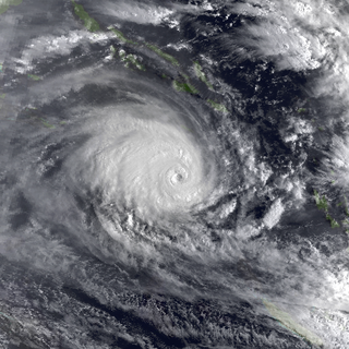
WSevere Tropical Cyclone Winston was the most intense tropical cyclone in the Southern Hemisphere on record, as well as the strongest to make landfall in the Southern Hemisphere, with the possible exception of 1899's Cyclone Mahina in both regards. Winston is also the costliest tropical cyclone on record in the South Pacific basin. The system was first noted as a tropical disturbance on 7 February 2016, when it was located to the northwest of Port Vila, Vanuatu. Over the next few days, the system gradually developed as it moved southeast, acquiring gale-force winds by 11 February. The following day, it underwent rapid intensification and attained ten-minute maximum sustained winds of 175 km/h (110 mph). Less favourable environmental conditions prompted weakening thereafter. After turning northeast on 14 February, Winston stalled to the north of Tonga on 17 February. Due to a change in higher level steering, the storm drifted back to the west. In the process, Winston again rapidly intensified, reaching Category 5 intensity on both the Australian tropical cyclone scale and the Saffir–Simpson hurricane wind scale on 19 February. The storm passed directly over Vanua Balavu, where a national record wind gust of 306 km/h (190 mph) was observed.
 W
WSevere Tropical Cyclone Xavier was a strong pre-season cyclone that formed on October 20, 2006 to the north of the Santa Cruz Islands. Cyclone Xavier was also the strongest storm of the season. During the next day it rapidly developed and was designated as Tropical Depression 01F later that day, before being designated as Tropical Cyclone Xavier while over Santa Cruz early on October 22. Later on October 22, Xavier intensified into a category 3 severe tropical cyclone on the Australian Tropical Cyclone Intensity Scale, before passing over Tikopia early the next day. Xavier then reached its peak wind speeds of 175 km/h, which made it a Category 4 cyclone early on October 24. Xavier stayed at its peak wind speeds until early the next day when it started to rapidly weaken, becoming a depression early on October 26. The remnants of Xavier persisted until October 28 before dissipating. There were no casualties reported as a result of the storm and little impact reported in the Solomon Islands and Vanuatu.
 W
WSevere Tropical Cyclone Yasi was a powerful and destructive tropical cyclone that made landfall in northern Queensland, Australia in early 2011, causing major damage to the affected areas. Originating as a tropical low near Fiji on 26 January, the system intensified to tropical cyclone status during the evening of 30 January. Yasi deepened rapidly over the next 24 hours, and was classified as a Category 3 cyclone at about 5 PM AEST on 31 January 2011. Late on 1 February, the cyclone strengthened to a Category 4 system; then, early on 2 February, the cyclone intensified into a Category 5 Severe Tropical Cyclone. The system had a well-defined eye and continued to track west-southwestward, maintaining a central pressure of 930 hPa and a Dvorak intensity of T6.5 into the evening.