 W
WThe Ahlsburg is a range of bunter sandstone hills, relatively small in area and up to 411.4 m above sea level (NN), in the southern part of Lower Saxony, Germany. It lies within the Solling foreland and is part of the Weser-Leine Uplands.
 W
WThe Amtsberge are a relatively small ridge, up to 392.2 m above sea level (NN),near Dassel in southern Lower Saxony in Germany.
 W
WThe Barnbruch is a wetland of international importance in the old glacial valley of the river Aller that provides a habitat for endangered species of birds, amphibians and insects. It lies between the city of Wolfsburg and town of Gifhorn and consists of an enclosed woodland area of around 1,500 hectares with surrounding meadows and pastures. This low-lying depression lies partly within the territory of the city of Wolfsburg and partly within Gifhorn district. Together with the Drömling around 15 km to the east, the Barnbruch is the most valuable ecological lowland region along the upper course of the Aller.
 W
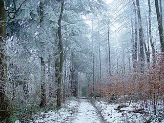
WThe Bramwald is a range of hills up to 408.1 m above sea level (NN) in the Weser Uplands in Lower Saxony (Germany). It is a unique, natural, wild, hill and forest landscape. This is particularly so in the north around the Totenberg.
 W
WThe Damme Hills are a high, wooded ridge, up to 146 m above sea level (NN), in the Oldenburg Münsterland in the southern part of the district of Vechta, in western Lower Saxony, Germany.
 W
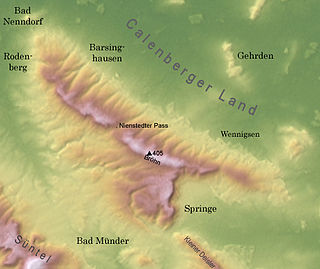
WThe Deister is a chain of hills in the German state of Lower Saxony, about 15 mi (25 km) southwest of the city of Hanover. It runs in a north-westerly direction from Springe in the south to Rodenberg in the north. The next in the chain of hills to the south is the Kleiner Deister from which it is separated by the flat pass of the Deister Gate. It is surrounded by Springe, Wennigsen, Barsinghausen, Bad Nenndorf, Rodenberg and Bad Münder.
 W
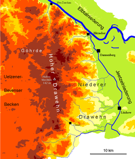
WThe Drawehn is a partly wooded and partly agricultural region of hills in the northeastern part of the German state of Lower Saxony, lying between the districts of Lüneburg and Uelzen in the west and Lüchow-Dannenberg in the east.
 W
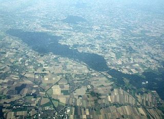
WDrömling is a sparsely populated depression on the border of Lower Saxony and Saxony-Anhalt in Germany with an area of about 340 square kilometres (130 sq mi). The larger part belonging to Saxony-Anhalt in the east has been a nature park since 1990. The former swampland was transformed by drainage from a natural into a cultural landscape in the 18th century under the direction of Frederick the Great of Prussia. Today the depression, with its waterways, the Mittelland Canal and the rivers Aller and Ohre is a refuge for rare or endangered species of animal and plant. Most of the area is now made up of nature reserves and protected areas. Nearby towns include Oebisfelde and Wolfsburg.
 W
WThe Eilenriede is a 640-hectare (1,600-acre) municipal forest in Hannover, Germany. It is the largest urban city forest in Germany, and also one of the largest in Europe. The Eilenriede is nearly twice the size of Central Park. The biggest German urban "park" in the strict sense of the word, however, is the Englischer Garten München, with "only" 375-hectare (930-acre).
 W
WEllensen Forest is a low mountain range in the Leine Uplands, sited at the ciy of Dassel in South Lower Saxony, Germany. It is named for Ellensen, a district of Dassel.
 W
WThe Elm is a range of hills north of the Harz mountains in the Helmstedt and Wolfenbüttel districts of Lower Saxony, Germany. It has a length of about 25 km (15.5 mi) and a width of 3–8 km (2–5 mi) and rises to an elevation of 323 meters. Surrounded by the Northern European Lowlands, the Elm is almost uninhabited and the largest beech forest in Northern Germany. The hills are of a triassic limestone called Elmkalkstein. Together with the neighbouring Lappwald range, the Elm has been a protected nature park since 1977.
 W
WThe Göttingen Forest is a ridge in Germany's Central Uplands that is up to 427.5 metres high. It forms part of the Lower Saxon Hills in South Lower Saxony.
 W
WThe Grinderwald is a mixed forest and a low hill range, up to 101 m above sea level (NN), in Hanover Region and the Lower Saxon district of Nienburg/Weser in Germany.
 W
WThe Hainberg is a hill range, up to 299 metres high, northwest of the Harz Mountains in the eastern part of Lower Saxony, Germany.
 W
WThe Harly Forest is a hill range up to 256 m (840 ft) above NN in the district of Goslar in southeastern Lower Saxony, Germany.
 W
WThe Harz is a highland area in northern Germany. It has the highest elevations for that region, and its rugged terrain extends across parts of Lower Saxony, Saxony-Anhalt, and Thuringia. The name Harz derives from the Middle High German word Hardt or Hart, Latinized as Hercynia. The Brocken is the highest summit in the Harz with an elevation of 1,141.1 metres (3,744 ft) above sea level. The Wurmberg is the highest peak located entirely within the state of Lower Saxony.
 W
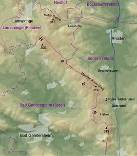
WThe Heber is a hogback ridge, relatively small in area and up to 313.5 metres high, in the Lower Saxon Hills within the districts of Goslar, Northeim and Hildesheim in the German state of Lower Saxony.
 W
WThe Hildesheim Forest is a range of hills up to 359 m above sea level (NN) in the district of Hildesheim in the German state of Lower Saxony.
 W
WThe Holzberg is a small range of hills up to 444.5 m above sea level (NHN) in south Lower Saxony, Germany.
 W
WThe Hümmling is a ground moraine landscape, up to 73 m above sea level (NN), in the Emsland region on the North German Plain in the western part of the German state of Lower Saxony.
 W
WThe Kaufungen Forest is a range of steep, wooded hills straddling the border between the states of Hesse and Lower Saxony in central Germany. It takes its name from the town Kaufungen.
 W
WThe Lappwald is a heavily wooded range of hills, 20 km long and up to 5 km wide, in central Germany. It stretches northwards from the town of Helmstedt. The border between Lower Saxony and Saxony-Anhalt runs through the woods, of which about three quarters is on Lower Saxon terrain. The Lappwald is part of the Elm-Lappwald Nature Park.
 W
WLüneburg Heath is a large area of heath, geest, and woodland in the northeastern part of the state of Lower Saxony in northern Germany. It forms part of the hinterland for the cities of Hamburg, Hanover and Bremen and is named after the town of Lüneburg. Most of the area is a nature reserve. Northern Low Saxon is still widely spoken in the region.
 W
WThe Rehburg Hills are a hill range, up to 161.4 m above sea level (NN), in the districts of Nienburg and Schaumburg in Lower Saxony, Germany.
WThe Rotenberg is a hill range, up to 317.3 m high, in the Lower Saxon Hills in southeastern Lower Saxony, Germany.
 W
WThe Sackwald is a ridge, up to 374 m above sea level (NN) high, in the Lower Saxon Hills in the district of Hildesheim in the North German state of Lower Saxony. It is named after the village of Sack in the borough of Alfeld, the name meaning "Sack Forest".
 W
WThe Salzgitter Hills is an area of upland up to 322.9 metres (1,059 ft) in height, in the Lower Saxon Hills between Salzgitter and Goslar in the districts of Wolfenbüttel and Goslar and in the territory of the independent town of Salzgitter. The hills lie in the German federal state of Lower Saxony.
 W
WThe Schaumburg Forest is a wooded region, about 80 m above sea level (NN) with an area of around 40 km², in the district of Schaumburg in the German federal state of Lower Saxony.
 W
WThe Solling is a range of hills up to 527.8 m above sea level (NN) high in the Weser Uplands in the German state of Lower Saxony, whose extreme southerly foothills extend into Hesse and North Rhine-Westphalia.
 W
WThe Solling-Vogler Nature Park is a nature park in South Lower Saxony in Germany. It has an area of 52,000 hectares (200 sq mi) and was established in 1966.
 W
WThe Süntel (help·info) is a massif in the German Central Uplands that is up to 437.5 m above sea level (NN). It forms part of the Weser Uplands in Lower Saxony southwest of Hanover and north of Hamelin.
 W
WThe Teutoburg Forest is a range of low, forested hills in the German states of Lower Saxony and North Rhine-Westphalia. In 9 AD, this region was the site of a major Roman defeat, the Battle of the Teutoburg Forest. Until the 19th century, the official name of the hill ridge was Osning.
WThe Totenberg, at 408.1 m above sea level (NN), is the highest hill in the Bramwald, a forested hill range in the Weser Uplands in South Lower Saxony.
WThe Vorberge are a ridge, up to 353 m above sea level (NN) high, in the Lower Saxon Hills and within the district of Hildesheim in the German state of Lower Saxony. Together with the Sieben Berge and the Sackwald, the Vorberge belong to the geological formation of the Sackmulde.
 W
WThe Vorholz is a ridge up to 243 m high in the districts of Hildesheim and Wolfenbüttel in the German state of Lower Saxony.