 W
WArea codes 631 and 934 are the telephone area codes for Suffolk County, New York, comprising mainly the central and eastern part of Long Island. Area code 631 was created in 1999 as a division from area code 516, and 934 was added as an overlay in 2016. Communities within the plan area include Babylon, Brookhaven, Huntington, Patchogue, Riverhead, Smithtown, Southold, Shelter Island, and the area of The Hamptons.
 W
WBattle Hill is the highest natural point in Brooklyn, New York, United States, at 216 feet (66 m) above sea level. The hill is part of the Harbor Hill Moraine, a terminal moraine formed during the last glacial period. Battle Hill, located in what is today Green-Wood Cemetery, received its name from the battle which occurred on its slopes between American troops under the immediate command of General Samuel Holden Parsons and British troops under the command of General James Grant.
 W
WBelmont Lake State Park is a 463-acre (1.87 km2) day-use state park located in the Town of Babylon in Suffolk County, New York on Long Island.
 W
WBig Reed Pond is a freshwater pond located in Montauk, New York on Long Island. A 128-acre (0.52 km2) site including the pond, brackish marshland and natural sand dunes was designated as a National Natural Landmark in 1973. The largely undeveloped pond is located within Theodore Roosevelt County Park.
 W
WBrentwood State Park is a 52-acre (0.21 km2) state park and athletic field complex located in the hamlet of Brentwood in Suffolk County, New York, United States.
 W
WBridge Plaza is the northeastern corner of the downtown area of the New York City borough of Brooklyn. Its borders are Flatbush Avenue Extension and Manhattan Bridge on the west, Tillary Street on the south, and the Brooklyn-Queens Expressway (BQE) on the north and east.
WBrookhaven State Park is a 1,638-acre (6.63 km2) state park in Wading River, New York, approximately 74 miles (119 km) east of New York City. Established in 1971, the park land was formerly the property of Brookhaven National Laboratory. Protecting a large amount of the Long Island Pine Barrens, the park also contains scattered wetlands.
 W
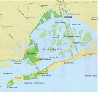
WCanarsie Pol is an uninhabited island south of Canarsie, Brooklyn in Jamaica Bay, New York City. It is part of Gateway National Recreation Area. Canarsie Pol is an irregular oval of about 300 acres (120 ha). On 1910 maps, the island was originally much smaller; however, when nearby waterways were dredged to expand them for improved navigation, the sand and soil were piled on Canarsie Pol. Near the island are other islands and marshes in the bay. Canarsie Pol has an elevation of 10 feet (3.0 m), and is a popular destination for kayakers embarking from the Canarsie Pier.
 W
WClam Pond is a small cove in the Great South Bay, on the north side of Fire Island between Saltaire and Fair Harbor in Suffolk County, New York. It is a popular spot for kayaking and small boat sailing.
 W
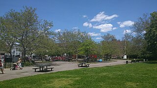
WCommodore Barry Park is an urban park in the Fort Greene neighborhood of the New York City borough of Brooklyn. The park is operated by the New York City Department of Parks and Recreation. It encompasses an area of 10.39 acres (42,000 m2) and holds baseball, basketball, football, swimming pool and playground fields/facilities. The park was acquired in 1836 by the Village of Brooklyn. When first acquired, it was called "City Park". It is the oldest park in the borough, and it was named for Commodore John Barry in 1951 due to its location next to the Brooklyn Navy Yard that Barry helped found.
 W
WThe Connetquot River is a six-mile-long (10 km) river in Islip, New York. It is one of the four longest rivers on Long Island and is recognized by the state as a Wild, Scenic and Recreational River. It is particularly known for its brook, brown and rainbow trout fly fishing.
WDunewood is a small beach community in the western end of Fire Island, New York State. With about 100 homes originally all built on an identical floor plan, While the community specifically does not market itself to tourists and short-term renters, it is a popular location for long-term residents, and properties are rarely for sale. The community has only very limited facilities, and while during summertime, it shares a doctor with nearby Fair Harbor, during other times of the year, serious medical cases have to be medevaced by helicopter.
 W
WFulton Park is a park in Bedford-Stuyvesant, Brooklyn, New York City, named after Robert Fulton, who is best known for launching the first commercially successful steamboat. The site on Chauncey Street was acquired by the City in 1904 for just over $300,000.
 W
WGardiners Bay is a small arm of the Atlantic Ocean, approximately 10 mi (16 km) long and 8 mi (13 km) wide in the U.S. state of New York between the two flukelike peninsulas at the eastern end of Long Island. It is bounded on its eastern end, where it connects to Block Island Sound, by Gardiners Island and Promised Land.
WHallock State Park Preserve is a 225-acre (0.91 km2) state park and nature preserve located in the towns of Riverhead and Southold in Suffolk County, New York. The park is situated on Long Island's north shore, with nearly one mile (1.6 km) of beachfront facing Long Island Sound.
 W
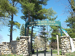
WHeckscher Park is a local park and national historic district in Huntington, Suffolk County, New York. It is bounded by Madison Street, Sabbath Day Path, Main Street, and Prime Avenue. The park is roughly triangular-shaped with a large pond on northwest corner, and contains the Heckscher Museum of Art established by industrialist August Heckscher, as well as the Chapin Rainbow Theater. It hosts annual art festivals, tulip festivals, concerts, renaissance fairs, and the Huntington Summer Arts Festival. Heckscher Park was listed on the National Register of Historic Places in 1985.
 W
WHicks Island is an island in Napeague Bay, Suffolk County, New York, in the United States. The small island is located north of Napeague on the eastern end of Long Island.
 W
WHither Hills State Park is a 1,755-acre (7.10 km2) state park located on the eastern end of the South Fork of Long Island near the hamlet of Montauk, New York.
 W
WJohn J. Carty Park, also known as Rubber Park, is located in Bay Ridge, Brooklyn. This park honors John J. Carty (1909–1970), a native of Bay Ridge, Brooklyn who lived his life only five blocks away and dedicated himself to New York City government for 32 years.
WKismet is a hamlet in the town of Islip, Suffolk County, New York, United States. It is the westernmost beach community on Fire Island, immediately west of Saltaire and east of the Fire Island Light. Kismet is accessible by road or on foot via Robert Moses State Park to the west, or by ferry from Bay Shore on Long Island.
 W
WLittle Gull Island is a small island in Long Island Sound, located approximately 0.4 miles (0.6 km) northeast of Great Gull Island. Both islands are located in the Town of Southold, in Suffolk County, New York, and lie roughly midway between Plum Island and Fishers Island. Little Gull Island is approximately 4.6 miles (7.4 km) southwest of Fishers Island and the channel of water between them is the main entrance to Long Island Sound, known as The Race.
 W
WMau Mau Island, also called White Island, is a small uninhabited island in the New York City borough of Brooklyn, located between Gerritsen Creek and Mill Creek in the Marine Park recreation area. Historically, the area around Mau Mau Island was a salt marsh with shifting topography. The island came into existence permanently after 1917, and most likely formed in 1934 as dumping led to the current shoreline.
 W
WOrient Beach State Park is a 363-acre (1.47 km2) state park located in the Town of Southold in Suffolk County, New York in the United States. The park is at the tip of the North Fork of Long Island.
 W
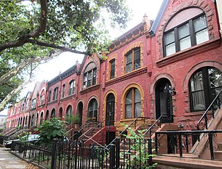
WThe Park Place Historic District is a small historic district located on Park Place between Bedford and Franklin Avenues in the Crown Heights neighborhood of Brooklyn, New York City. It consists of 13 row houses from #651 to the east to #675 to the west, which were built in 1899-90 and designed by J. Mason Kirby in a combination of the Queen Anne and Romanesque Revival styles.
 W
WThe Paumanok Path is a 125-mile (201 km) hiking trail in New York on Long Island that goes from Rocky Point to Montauk Point State Park. It travels through four towns in Suffolk County: Brookhaven, Riverhead, Southampton and East Hampton.
 W
WThe Peconic River is a river within Suffolk County on Long Island, New York in the United States. The river is located in the eastern end of Long Island. The Peconic River drains an area between the Harbor Hill and Ronkonkoma terminal moraines, and flows into Flanders Bay which in turn connects to Peconic Bay east of Riverhead.
 W
WRockaway Inlet is a strait connecting Jamaica Bay, wholly within New York City, with the Atlantic Ocean. It separates the Rockaway Peninsula in Queens from the Floyd Bennett Field in Brooklyn.
 W
WShadmoor State Park is a 99-acre (0.40 km2) state park located in Suffolk County, New York in the United States. Created in 2000, the park is located in Town of East Hampton on the South Fork of Long Island, one-quarter mile (0.40 km) east of the hamlet of Montauk.
WSouth Jamesport is a hamlet in the town of Riverhead, Suffolk County, New York, United States. The community is located on the north shore of the Great Peconic Bay. South Jamesport has a post office with ZIP code 11970, which opened on February 2, 1893.
 W
W W
WSouthaven County Park is located in Brookhaven and South Haven, New York in central Long Island. It is located between Sunrise Highway just west of William Floyd Parkway, off of Victory Avenue, and crossed by the Carmans River.
WUpton, New York is a hamlet and census-designated place (CDP) on Long Island in the town of Brookhaven. It is the home of the Brookhaven National Laboratory and a National Weather Service weather forecast office.
 W
WWalt Whitman Park is a park in the Downtown Brooklyn section of Brooklyn, New York City, commemorating Walt Whitman. It is adjacent to Cadman Plaza East to the west and Adams Street to the east.
WWater Island is a hamlet in Suffolk County, New York, on Fire Island.
 W
WWildwood State Park is a 767-acre (3.10 km2) state park located in Suffolk County, New York. The park is in the Town of Riverhead on the north shore of Long Island. The park includes a beach on Long Island Sound.