 W
WAngel is a locality on the northern fringes of Central London within the London Borough of Islington. It is located 2 miles (3.2 km) north-northeast of Charing Cross on the Inner Ring Road at a busy transport intersection. The area is identified in the London Plan as one of 35 major centres in London. It is a significant commercial and retail centre, and a business improvement district. Angel straddles the ancient boundary of the parishes of Clerkenwell and Islington that later became the metropolitan boroughs of Finsbury and Islington. It is named from the former Angel Inn which stood on the corner of Islington High Street and Pentonville Road. Since 1965 the whole area has formed part of the London Borough of Islington in Greater London.
 W
WBarking is a district of East London and the administrative centre of the London Borough of Barking and Dagenham, with a population of 59,068. It is 9.3 miles (15 km) east northeast of Charing Cross. It was historically an ancient parish in the county of Essex that straddled the River Roding. It underwent a shift from fishing and farming to market gardening and industrial development on the River Thames. Barking railway station opened in 1854 and has been served by the London Underground since 1908. As part of the suburban growth of London in the 20th century, Barking significantly expanded and increased in population, primarily due to the development of the London County Council estate at Becontree in the 1920s, and became a municipal borough in 1931, and part of Greater London in 1965. In addition to an extensive and fairly low-density residential area, the town centre forms a large retail and commercial district, currently a focus for regeneration. The former industrial lands to the south are being redeveloped as Barking Riverside.
 W
WBexleyheath is a town in the London Borough of Bexley in Greater London, England with a population of 31,929. It is 12 miles (19.3 km) south-east of Charing Cross, and is identified in the London Plan as one of 35 major centres in Greater London.
 W
WBrixton is a district of South London, England, within the London Borough of Lambeth. The area is identified in the London Plan as one of 35 major centres in Greater London.
 W
WCamden Town, often shortened to Camden, is a district of northwest London, England, 2.5 miles (4.1 km) north of Charing Cross. Historically in Middlesex, it is the administrative centre of the London Borough of Camden, and identified in the London Plan as one of 34 major centres in Greater London.
 W
WCanary Wharf is the secondary central business district of London on the Isle of Dogs. Along with the City of London, it is one of the main financial centres of the United Kingdom and the world, containing many of their tallest buildings, including the third-tallest in the UK, One Canada Square.
 W
WCatford is a district of south east London, England, and the administrative centre of the London Borough of Lewisham. It is southwest of Lewisham itself, mostly in the Rushey Green and Catford South wards. The population of Catford, including the Bellingham, London neighbourhood, was 44,905 as of 2011.
 W
WChiswick is a district of West London, England. It contains Hogarth's House, the former residence of the 18th-century English artist William Hogarth; Chiswick House, a neo-Palladian villa regarded as one of the finest in England; and Fuller's Brewery, London's largest and oldest brewery. In a meander of the River Thames used for competitive and recreational rowing, with several rowing clubs on the river bank, the finishing post for the Boat Race is just downstream of Chiswick Bridge.
 W
WDalston is an area of East London, in the London Borough of Hackney. It is 4 miles (6.4 km) north-east of Charing Cross. Dalston began as a hamlet on either side of Dalston Lane, and as the area urbanised the term also came to apply to surrounding areas including Kingsland and Shacklewell, all three of which being part of the Ancient Parish of Hackney.
 W
WEast Ham is a district of the London Borough of Newham, England, 8 miles (12.8 km) east of Charing Cross. East Ham is identified in the London Plan as a Major Centre. The population is 76,186.
 W
WEdgware is a suburban town in north London, mostly in the London borough of Barnet but with a small part falling in Harrow. Edgware is centred 9.5 miles (15.3 km) north-northwest of Charing Cross and has its own commercial centre. Edgware has a generally suburban character, typical of the rural-urban fringe. It was an ancient parish in the county of Middlesex directly east of the ancient Watling Street, and gives its name to the present day Edgware Road that runs from central London towards the town. The community benefits from some elevated woodland on a high ridge marking the Hertfordshire border of gravel and sand. It includes the areas of Burnt Oak, The Hale, Edgwarebury, Canons Park, and parts of Queensbury.
 W
WEltham is a district of southeast London, England, within the Royal Borough of Greenwich. It is 8.7 miles (14.0 km) east-southeast of Charing Cross, and is identified in the London Plan as one of 35 major centres in Greater London. The three wards of Eltham North, South and West have a total population of 35,459.
 W
WEnfield is a market town in Greater London, and is the historic centre of the London Borough of Enfield. It is 10.1 miles (16.3 km) north-northeast of Central London. The area is identified in the London Plan as one of 35 major centres in Greater London. The town was originally in the county of Middlesex, but became part of Greater London on 1 April 1965 when the London Government Act 1963 was implemented. Enfield, including its localities such as Ponders End, Crews Hill and Freezywater, had a total population of 132,640 in 2011; the wider borough meanwhile had a population of 333,869.
 W
WFulham is an area of the London Borough of Hammersmith and Fulham in southwest London, England, 3.6 miles (5.8 km) southwest of Charing Cross. It lies on the north bank of the River Thames, between Hammersmith and Kensington and Chelsea, facing Wandsworth, Putney and Barn Elms, with the London Wetland Centre in Barnes.
 W
WHammersmith is a district of west London, England, located 4.3 miles (6.9 km) west-southwest of Charing Cross. It is the administrative centre of the London Borough of Hammersmith and Fulham, and identified in the London Plan as one of 35 major centres in Greater London.
 W
WKensington High Street is the main shopping street in Kensington, London. The area is identified in the London Plan as one of 35 major centres in Greater London.
WKilburn is an area of north west London, England, which spans the boundary of two London Boroughs: Camden to the east and Brent to the west. There is also an area in the London Borough of Westminster, known as West Kilburn and sometimes treated as a distinct locality. Kilburn High Road railway station lies 3.5 miles (5.6 km) north-west of Charing Cross.
 W
WKing's Road or Kings Road, is a major street stretching through Chelsea and Fulham, both in west London. It is associated with 1960s style and with fashion figures such as Mary Quant and Vivienne Westwood. Sir Oswald Mosley's Blackshirt movement had a barracks on the street in the 1930s.
 W
WLewisham is an area of south east London, England, 5.9 miles (9.5 km) south of Charing Cross. It is the principal area of the London Borough of Lewisham, and is also within the historic county of Kent. It is identified in the London Plan as one of 35 major centres in Greater London. Lewisham had a population of 60,573 in 2011.
 W
WNag's Head is a locality within the Holloway area of the London Borough of Islington.
 W
WOrpington is a town and electoral ward in Greater London, England, at the south-eastern edge of the London conurbation; it is part of the London Borough of Bromley, it is identified in the London Plan as one of 35 major centres in Greater London. It is located 13.3 miles from Charing Cross, situated south of St Mary Cray, west of Ramsden, north of Goddington and Green Street Green, and east of Crofton and Broom Hill. Orpington is a part of the BR postcode area consisting of the BR6 district.
 W
WPeckham is a district of south London, England, within the London Borough of Southwark. It is 3.5 miles (5.6 km) south-east of Charing Cross. At the 2001 Census the Peckham ward had a population of 14,720.
 W
WPutney is a district in southwest London, England, in the London Borough of Wandsworth. It is centred 4.9 miles (7.9 km) southwest of Charing Cross. The area is identified in the London Plan as one of 35 major centres in Greater London.
 W
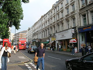
WQueensway is a busy shopping street in Bayswater, an area of west London. It is home to Whiteleys, many restaurants, cafés, pubs, souvenir shops and a few high-street retail chains. Queensway and Westbourne Grove are identified in the London Plan as one of 35 major centres in Greater London. The street is numbered the B411 in the British road numbering scheme. Queensway is currently undergoing a major redevelopment on all sides, with a building on the top of the road being developed for £500m, Whiteleys for £1.2BN and a series of other redevelopments happening at the same time.
WRichmond is a town in south-west London, 8.2 miles (13.2 km) west-southwest of Charing Cross. It is on a meander of the River Thames, with many parks and open spaces, including Richmond Park, and many protected conservation areas, which include much of Richmond Hill. A specific Act of Parliament protects the scenic view of the River Thames from Richmond.
 W
WSouthall is a large suburban district of west London, England, and part of the London Borough of Ealing, and is one of its seven major towns. It is situated 10.7 miles (17.2 km) west of Charing Cross. Nearby places include Yeading, Hayes, Hanwell, Hounslow, Greenford, Northolt, Ealing and Acton. The area is identified in the London Plan as one of 35 major centres in Greater London. It had a population of 69,857 as of 2011.
 W
WStratford is a district in the East End of London, in the London Borough of Newham, England. It is 6 miles (10 km) east-northeast of Charing Cross and is in East London. Stratford is part of the Lower Lea Valley and includes the localities of Maryland, East Village, Mill Meads, Stratford City and Forest Gate. It is historically part of the ancient parish and subsequent County Borough of West Ham, which became the western half of the modern borough within a Greater London in 1965. Historically an agrarian settlement in the county of Essex, Stratford was transformed into an industrial suburb after the introduction of the railway in 1839.
 W
WStreatham is a district mostly in the London Borough of Lambeth in Greater London, but with some areas to the west stretching out into the neighbouring London Borough of Wandsworth. It is centred 5 miles (8.0 km) south of Charing Cross. The area is identified in the London Plan as one of 35 major centres in Greater London.
 W
WTooting is a district of South London, England, forming part of the London Borough of Wandsworth and partly in the London Borough of Merton. It is located 5 miles south south-west of Charing Cross.
 W
WWalthamstow is a major district in the London Borough of Waltham Forest, located 7.5 miles (12.1 km) north-east of Charing Cross and immediately east of the Lee Valley Reservoir Chain and the Walthamstow Marshes. Historically an ancient parish in the county of Essex, its population increased as part of the suburban growth of London, becoming the Municipal Borough of Walthamstow in 1929. In 1965 the district merged with neighbouring Leyton and Chingford to form the new Borough of Waltham Forest, a component of the new Greater London area.
 W
WWandsworth Town is a district of south London, within the London Borough of Wandsworth 4.2 miles (6.8 km) southwest of Charing Cross. The area is identified in the London Plan as one of 35 major centres in Greater London.
 W
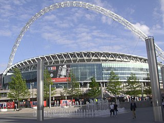
WWembley is the principal town of the borough of Brent in north west London, England, about 8 miles (13 km) west-northwest of Charing Cross. Wembley was formed a separate civil parish from 1894 and was incorporated as a municipal borough of Middlesex in 1937. In 1965, the area merged with the Municipal Borough of Willesden, which was separated by the River Brent, to create the London Borough of Brent, and has since formed part of Greater London.
 W
WWestbourne Grove is a retail road running across Notting Hill, a section of west London. Its western end is in the Royal Borough of Kensington and Chelsea and its eastern end is in the City of Westminster; it runs from Kensington Park Road in the west to Queensway in the east, crossing over Portobello Road. It contains a mixture of independent and chain retailers, and has been termed both "fashionable" and "up-and-coming".
 W
WWimbledon is a district and town of southwest London, England, 7.0 miles (11.3 km) southwest of the centre of London at Charing Cross, in the London Borough of Merton, south of Wandsworth, northeast of New Malden, northwest of Mitcham, west of Streatham and north of Sutton. Wimbledon had a population of 68,187 in 2011 which includes the electoral wards of Abbey, Dundonald, Hillside, Trinity, Village, Raynes Park and Wimbledon Park.
 W
WWoolwich is a district in southeast London, England, within the Royal Borough of Greenwich.