 W
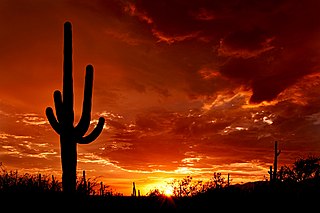
WThe Sonoran Desert is a North American desert and ecoregion which covers large parts of the Southwestern United States in Arizona and California and of Northwestern Mexico in Sonora, Baja California, and Baja California Sur. It is the hottest desert in Mexico. It has an area of 260,000 square kilometers (100,000 sq mi). The western portion of the United States–Mexico border passes through the Sonoran Desert.
 W
WThe Altar Valley is a 45-mile (72 km) long north-south valley, trending slightly northeast from Sasabe, Arizona on the Mexico border to the Avra Valley west of the Tucson Mountains. It is delimited by Arizona State Route 86, from east-to-west on the north separating it from the Avra Valley which then trends northwesterly, merging into the plains and drainage of the Santa Cruz River.
 W
WBlythe is a city in eastern Riverside County, California, United States. It is in the Palo Verde Valley of the Lower Colorado River Valley region, an agricultural area and part of the Colorado Desert along the Colorado River, approximately 224 miles (360 km) east of Los Angeles and 150 miles (240 km) west of Phoenix. Blythe was named after Thomas Henry Blythe, a San Francisco financier, who established primary water rights to the Colorado River in the region in 1877. The city was incorporated on July 21, 1916. The population was 20,817 at the 2010 census.
 W
WBoyce Thompson Arboretum is the largest and oldest botanical garden in the state of Arizona. It is one of the oldest botanical institutions west of the Mississippi. Founded in 1924 as a desert plant research facility and “living museum”, the Arboretum is located in the Sonoran Desert on 392 acres along Queen Creek and beneath the towering volcanic remnant, Picketpost Mountain. Boyce Thompson Arboretum is on U.S. Highway 60, an hour's drive east from Phoenix and 3 miles (4.8 km) west of Superior, Arizona.
 W
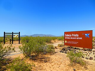
WCabeza Prieta National Wildlife Refuge (CPNWR) is located in southwestern Arizona in the United States, along 56 miles (90 km) of the Mexico–United States border. It is bordered to the north and to the west by the Barry M. Goldwater Air Force Range, to the south by Mexico's El Pinacate y Gran Desierto de Altar Biosphere Reserve, to the northeast by the town of Ajo, and to the southeast by Organ Pipe Cactus National Monument.
 W
WThe Cabeza Prieta Wilderness is located in the Sonoran Desert in southwestern Arizona in the United States. Cabeza Prieta Wilderness Area has the distinction of being Arizona's largest Wilderness Area, encompassing nearly 93 percent of the Cabeza Prieta National Wildlife Refuge and covering 803,418 acres (3,251.32 km2), larger than the land area of the state of Rhode Island. It may be temporarily closed for training exercises of the Barry M. Goldwater Air Force Range. It is also the reputed burial ground of famed environmentalist and author Edward Abbey.
 W
WCalifornia's Colorado Desert is a part of the larger Sonoran Desert. It encompasses approximately 7 million acres, including the heavily irrigated Coachella and Imperial valleys. It is home to many unique flora and fauna.
 W
WThe Colorado River is one of the principal rivers in the Southwestern United States and northern Mexico. The 1,450-mile-long (2,330 km) river drains an expansive, arid watershed that encompasses parts of seven U.S. states and two Mexican states. Starting in the central Rocky Mountains of Colorado, the river flows generally southwest across the Colorado Plateau and through the Grand Canyon before reaching Lake Mead on the Arizona–Nevada border, where it turns south toward the international border. After entering Mexico, the Colorado approaches the mostly dry Colorado River Delta at the tip of the Gulf of California between Baja California and Sonora.
 W
WThe Colorado River Delta is the region where the Colorado River flows into the Gulf of California in eastern Mexicali Municipality in the north of the state of Baja California in northwesternmost Mexico. The delta is part of a larger geologic region called the Salton Trough. Historically, the interaction of the river's flow and the ocean's tide created a dynamic environment, supporting freshwater, brackish, and saltwater species. Within the delta region, the river split into multiple braided channels and formed a complex estuary and terrestrial ecosystems. The use of water upstream and the accompanying reduction of freshwater flow has resulted in the loss of most of the wetlands of the area, as well as drastic changes to the aquatic ecosystems. However, a scheme is currently in place which aims to rejuvenate the wetlands by releasing a pulse of water down the river delta.
 W
WColossal Cave is a large cave system in southeastern Arizona, United States, near the community of Vail, about 22 miles (35 km) southeast of Tucson. It contains about 3.5 miles (5.6 km) of mapped passageways. Temperatures inside average 70 °F (21 °C) year-round. Previous names include 'Mountain Springs Cave' and 'Five–Mile Cave'.
 W
WThe Desert Laboratory is a historic biological research facility at 1675 West Anklam Road in Tucson, Arizona. It was founded by the Carnegie Institution in 1903 to study how plants survive and thrive in the heat and aridity of deserts, and was the first such privately funded effort in the nation. Beginning in 1906, numerous long term ecological observation areas were set up by Volney Spalding & Forrest Shreve on the 860 acres (3.5 km2) scientific domain of Tumamoc Hill. Nine of these are the world's oldest permanent ecology study quadrats. The facility and staff were key contributors to what is now considered the science of ecology, including participating in the creation of the Ecological Society of America in 1915 and the Ecology journal. Led by Spalding & Shreve, they also contributed innovations in conservation.
 W
WEl Camino del Diablo is a historic 250-mile (400 km) road that currently extends through some of the most remote and arid terrain of the Sonoran Desert in Pima County and Yuma County, Arizona. In use for at least 1,000 years, El Camino del Diablo is believed to have started as a series of footpaths used by desert-dwelling Native Americans. From the 16th to the 19th centuries, the road was used extensively by conquistadores, explorers, missionaries, settlers, miners, and cartographers. Use of the trail declined sharply after the railroad reached Yuma in 1870. In recognition of its historic significance, El Camino del Diablo was listed on the National Register of Historic Places in 1978. It has also been designated a Bureau of Land Management Back Country Byway.
 W
WEl Elegante is a maar located in the Gran Desierto de Altar in the Sonoran Desert, Mexico.
 W
WFort Romualdo Pacheco also called Fuerte de Laguna Chapala was a New Spain fort built in 1825 and was abandoned a year later in 1826. The fort was 100 feet square with thick stone and adobe walls. The fort was built by Lieutenant Alfrez Jose Antonio Romualdo Pacheco Sr. in response to the attacked on travelers on the route made by Juan Bautista de Anza's expedition in 1774 from Sonora to Alta California. The fort was built after Fernando Rivera y Moncada, many of his soldiers, Francisco Garcés and his local missionaries, were killed at Mission San Pedro y San Pablo de Bicuñer in that is called the Yuma Revolt or Yuma Massacre on July 18, 1781. The attack was by the Apache Quechan Indians. The Yuma Massacre closed the overland transportation between northern Mexico and Alta California for 50 years. This halted the immigration of Mexicans to Alta California. Lieutenant Pacheco with soldiers and cavalry from the Presidio de San Diego built the fort in later 1825 and early 1826. The fort was built just north of the New River and south of the Bull Head Slough in what is now Imperial, California. The Fort was only used for a few months in 1826. Pacheco returned to San Diego and put Ignacio Delgado in charge of the Fort. On April 26, 1826 the San Sebastian Kumeyaay Indians attacked the fort. Pacheco had heard about rumors of the attack and arrived during the attack with reinforcements from San Diego. Pacheco and his 25 lancers fought off the attack. In the battle, three soldiers were killed and three injured. In the battle, 28 Indians were killed. But, now the fort was surrounded by many Kumeyaay and Quechan warriors. Vastly outnumbered the Fort was abandoned and all returned to San Diego. Archeologists did digs at the site in 1958 before Imperial Valley College Museum removed the remains.
 W
WThe Gila River is a 649-mile (1,044 km)-long tributary of the Colorado River flowing through New Mexico and Arizona in the United States. The river drains an arid watershed of nearly 60,000 square miles (160,000 km2) that lies mainly within the U.S., but also extends into northern Sonora, Mexico. Indigenous peoples have lived along the river for at least 2,000 years, establishing complex agricultural societies before European exploration of the region began in the 16th century. However, European Americans did not permanently settle the Gila River watershed until the mid-19th century.
 W
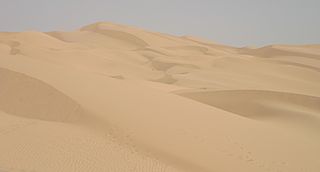
WThe Gran Desierto de Altar is one of the major sub-ecoregions of the Sonoran Desert, located in the State of Sonora, in northwest Mexico. It includes the only active erg dune region in North America. The desert extends across much of the northern border of the Gulf of California, spanning more than 100 kilometres (62 mi) east to west and over 50 kilometres (31 mi) north to south. It constitutes the largest continuous wilderness area within the Sonoran Desert.
 W
WThe Pinacate Peaks are a group of volcanic peaks and cinder cones located mostly in the Mexican state of Sonora along the international border adjacent to the U.S. state of Arizona, surrounded by the vast sand dune field of the Gran Desierto de Altar, at the desert's southeast.
 W
WHohokam was a society in the North American Southwest in what is now part of Arizona, United States, and Mexico. Hohokam practiced a specific culture, sometimes referred to as Hohokam culture, which has been distinguished by archeologists. People who practiced the culture can be called Hohokam as well, but more often, they are distinguished as Hohokam people to avoid confusion.
 W
WKartchner Caverns State Park is a state park of Arizona, United States, featuring a show cave with 2.4 miles (3.9 km) of passages. The park is located 9 miles (14 km) south of the town of Benson and west of the north-flowing San Pedro River. Long hidden from view, the caverns were discovered in 1974 by local cavers, assisted by a state biologist who helped in its preservation.
 W
WKitt Peak is a mountain in the U.S. state of Arizona, and at 6,883 feet (2,098 m) is the highest point in the Quinlan Mountains. It is the location of the Kitt Peak National Observatory. The radio telescope at the Observatory is one of ten dishes comprising the Very Long Baseline Array radio telescope.
 W
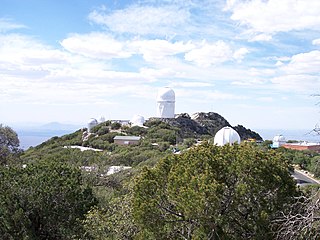
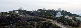
WThe Kitt Peak National Observatory (KPNO) is a United States astronomical observatory located on Kitt Peak of the Quinlan Mountains in the Arizona-Sonoran Desert on the Tohono O'odham Nation, 88 kilometers (55 mi) west-southwest of Tucson, Arizona. With over twenty optical and two radio telescopes, it is one of the largest gatherings of astronomical instruments in the northern hemisphere.
 W
WThe La Posa Plain is a wide, generally flat plain in western Arizona near the Colorado River and is on the west and northwest border of the Kofa National Wildlife Refuge. The plain lies to the east of the Colorado River Indian Reservation and east of the Dome Rock and Trigo Mountains. Quartzsite, Arizona, lies on the western part of the plain, which crosses both Interstate 10 and U.S. Route 95.
 W
WLake Havasu is a large reservoir formed by Parker Dam on the Colorado River, on the border between San Bernardino County, California and La Paz County, Arizona. Lake Havasu City sits on the Arizona (eastern) side of the lake with its Californian counterpart of Havasu Lake directly across the lake. The reservoir has an available capacity of 619,400 acre feet (764,000,000 m3). The concrete arch dam was built by the United States Bureau of Reclamation between 1934 and 1938. The lake's primary purpose is to store water for pumping into two aqueducts. Prior to the dam construction, the area was home to the Mojave Indians. The lake was named after the Mojave word for blue. In the early 19th century, it was frequented by beaver trappers. Spaniards also began to mine the areas along the river.
 W
WThe Lechuguilla Desert is a small desert located in southwestern Arizona near the U.S.-Mexico border. It is considered to be part of the Lower Colorado Valley region of the Sonoran Desert. It lies in a north-south direction between the Gila Mountains and the Cabeza Prieta Mountains, and almost entirely in the Barry M. Goldwater Air Force Range. The desert is named after the Lechuguilla plant, known scientifically as Agave lecheguilla which according to the Wikipedia entry for that occurs exclusively in the Chihuahuan desert many hundreds of miles to the east. The desert is also on the north border of the Gran Desierto de Altar of Sonora, Mexico.
 W
WMexicali Municipality is a municipality in the Mexican state of Baja California. Its municipal seat is located in the city of Mexicali. As of 2010, the municipality had a total population of 936,826, and according to the 2000 census, it had 764,602 inhabitants. The municipality has an area of 13,700 km2 (5,300 sq mi). This includes many smaller outlying communities as well as the city of Mexicali. Also, the islands of Baja California located in the Gulf of California are part of the municipality, among them the mudflat islands at the mouth of the Colorado River, Isla Ángel de la Guarda and the islands of the San Lorenzo Marine Archipelago National Park. Mexicali is the northernmost municipality of Latin America.
 W
WPicacho Peak State Park is a state park surrounding Picacho Peak in Picacho, Arizona. The park is located between Casa Grande and Tucson near Interstate 10 in Pinal County. Its centerpiece spire is visible from downtown Tucson, a distance of 45 miles (72 km). The summit rises to 3,374 feet (1,028 m) above mean sea level. Though appearing to be the remnant of a volcanic neck, it is now believed to be a tilted and eroded piece of rock overlain by a lava flow.
 W
WThe Pimería Alta was an area of the 18th century Sonora y Sinaloa Province in the Viceroyalty of New Spain, that encompassed parts of what are today southern Arizona in the United States and northern Sonora in Mexico.
 W
WThe Quinlan Mountains is a mountain range in the U.S. state of Arizona. Its highest point is Kitt Peak at 6,883 feet (2,098 m), which is also the second-highest peak on the Tohono O'odham Indian Reservation, after Baboquivari Peak. The range lies on the eastern end of the reservation about 55 miles (89 km) southwest of Tucson.
 W
WThe Rillito River is a river in Pima County, Arizona. It flows from east to west across the northern boundary of the City of Tucson from the confluence of Tanque Verde Creek and Pantano Wash to the Santa Cruz River 12.2 miles (19.6 km) away. The Rillito River Park runs along the north and south banks of the river from Interstate 10 to North Craycroft Road.
 W
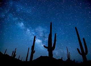
WSaguaro National Park is an American national park in Pima County, southeastern Arizona. The 92,000-acre (37,000 ha) park consists of two separate areas—the Tucson Mountain District (TMD) about 10 miles (16 km) west of the city of Tucson and the Rincon Mountain District (RMD) about 10 miles (16 km) east of the city—that preserve Sonoran Desert landscapes, fauna, and flora, including the giant saguaro cactus.
 W
WSonoran Desert National Monument is south of Goodyear and Buckeye and east of Gila Bend, Arizona. Created by Presidential proclamation on January 17, 2001, the 496,400 acres (200,886 ha) monument is managed by the U.S. Bureau of Land Management as part of the National Landscape Conservation System. The BLM already managed the lands, however under monument status, the level of protection and preservation of resources is enhanced. Sonoran Desert National Monument protects but a small portion of the Sonoran Desert, which is 120,000 square miles (311,000 km2), and extends well into California and the country of Mexico. The North Maricopa Mountains, South Maricopa Mountains and the Table Top Wildernesses protect the richest regions of desert habitat from development.
 W
WThe Spanish missions in the Sonoran Desert are a series of Jesuit Catholic religious outposts established by the Spanish Catholic Jesuits and other orders for religious conversions of the Pima and Tohono O'odham indigenous peoples residing in the Sonoran Desert. An added goal was giving Spain a colonial presence in their frontier territory of the Sonora y Sinaloa Province in the Viceroyalty of New Spain, and relocating by Indian Reductions settlements and encomiendas for agricultural, ranching, and mining labor.
 W
WThe Tombstone Epitaph is a Tombstone, Arizona monthly publication that covers the history and culture of the Old West. Founded in January 1880, The Epitaph is the oldest continually published newspaper in Arizona.
WThe Tonopah Desert is a small desert plains region of the Sonoran Desert, located west of Phoenix, Arizona. It is adjacent north of Interstate 10 and lies at the southwest intersection of the Hassayampa River with the Gila River. The Tonopah Desert is also just north of the Gila Bend Mountains massif which create the Gila Bend of the river.
 W
WThe Yuma Desert is a lower-elevation section of the Sonoran Desert in the southwestern United States and the northwest of Mexico. It lies in the Salton basin. The desert contains areas of sparse vegetation and has notable areas of sand dunes. With an average rainfall less than 8 inches (200 mm) each year, this is among the harshest deserts in North America. Human presence is sparse throughout, the largest city being Yuma, Arizona, on the Colorado River and the border of California.