 W
WAaiha is a village, plain, lake, and temporary wetland situated in the Rashaya District and south of the Beqaa Governorate in Lebanon. It is located in an intermontane basin near Mount Hermon and the Syrian border, approximately halfway between Rashaya and Kfar Qouq.
 W
WAbadiyeh is a municipality in the Baabda District of Mount Lebanon Governorate, Lebanon. It is located 16 kilometers east of Beirut. There is one public school in the town, which had 345 pupils in 2006. It is the hometown of Lebanese actress Cyrine Abdelnour, Lebanese footballer Zaher Al Indari, and former President of Brazil Michel Temer.
 W
WAin Dara, is a village about 30 kilometres (19 mi) from Beirut, in the governorate of Mount Lebanon, in the Aley District. Ain Dara Municipality has an area of 2,586 hectares (9.98 sq mi), with a population of approximately 8000 persons. It had 3,874 registered voters in 2010. Originally a Druze village, Ain Dara today is a mixed Druze and Christian village, with a Christian majority, as per the recent registered voters.
 W
WAinab, is a town on the western slopes of Mount Lebanon overlooking Beirut. It is in the Aley District of the Mount Lebanon Governorate 25 kilometres (16 mi) from Beirut, on the road South from Aley.
WAinbal is a village and municipality in the Chouf District of the Mount Lebanon Governorate in Lebanon. It is located 50 kilometers southeast of Beirut. Its average elevation is 850 meters above sea level and its total land area is 360 hectares. In 2010, Ainbal had 1,813 registered voters. Ainbal's inhabitants are predominantly Druze.
WAley is a major city in Lebanon. It is the capital of the Aley District and fourth largest city in Lebanon.
 W
WAmmatour is a town and municipality in the Shouf (Al-Shouf) District in Mount Lebanon Governorate of Lebanon. It lies 57 km southeast of Beirut, at an elevation of between 800 and 1,050 meters above sea level. The name "Ammatour" is derived from the words 'Ain Maa Tour', meaning the spring of the mountain. Ammatour is one of Lebanon's richest villages in sources of water with more than 365 springs, fountains, and a river located within its jurisdiction.
WAitat, or Aytat, is a town located 5 kilometres (3.1 mi) west of the town of Aley within the district of the same name in the Lebanese governorate of Mount Lebanon. It was a strategic place during the Lebanese Civil War (1975–1990), due to its view to Beirut.
 W
WBaakline is a major Druze town located in Mount Lebanon, Chouf District, 45 kilometers southeast of Beirut. Altitude 850 – 920 meters high, population is 30,000, area 14 square km, number of homes 2,870. Bordering Towns: Deir El Qamar, Beit Eddine, Aynbal, Deir Dourit, Symkanieh, and Jahlieh.
WBakaata is a town located in the Chouf District of the Mount Lebanon Governorate, about 45 kilometres (28 mi) southeast of Beirut. Its altitude ranges between 850 m (2,790 ft) – 950 m (3,120 ft) high. Bordering towns include Symkanieh, Ain wa Zein, and Jdeidet El Shouf. Its inhabitants are predominantly Druze.
 W
WBarouk is a village in the Chouf District of Mount Lebanon Governorate in Lebanon. Barouk is located 52 kilometers southeast of Beirut. Its average elevation is 1000 to 1200 meters above sea level and its total land area consists of 2,762 hectares. The village had 5,197 registered voters in 2010. Its inhabitants are predominantly Druze and Maronite and Melkite Christians.
 W
WBechamoun, is an area near Beirut in the Mount Lebanon Governorate of Lebanon. It has an elevation between 40 and 580 meters above sea level, 8 kilometers from Beirut airport and Beirut downtown. Bechamoun's population exceeds 15,000
WBmahray, is a village in the Aley District in Lebanon. It lies 41 km south-East of Beirut at an altitude of 1215m above sea level.
WCharoun or Sharoun, is a Lebanese village located in the Aley District. Charoun is 31 kilometers away from Beirut and neighbors the town Saoufar. Its name derives from the Aramaic languages meaning the agricultural hills. Charoun is from the Jurd region, with an 1350 m altitude. It accounts two schools, one public school and one private school. Charoun has two industries with 5 or more workers. Charoun is one of the biggest villages in the Aley District.
 W
WChbaniyeh is a municipality in the Baabda District of Mount Lebanon Governorate, Lebanon. It is 29 kilometres (18 mi) north of Beirut. Chbaniyeh has an average elevation of 860 metres (2,820 ft) above sea level and a total land area of 485 hectares. It has a religiously-mixed population Maronites, Melkites and Druze.
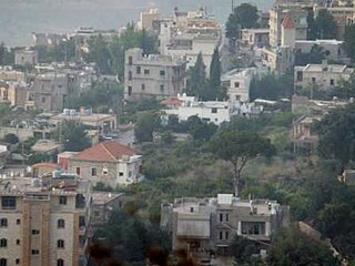
WChoueifat is one of the biggest and most important cities in southeast of Beirut in Lebanon. The town is a Druze enclave that lies on the eastern side of Beirut's airport. The local population of the city is made up of mostly Druze and Christians minority, but in the last 25 years, many Beirutis have moved in to escape the capital's high rents, while many southerners have found Choueifat a good alternative to the crowded southern suburb known as Dahieh.
WDahr Al-Ahmar is a village in Lebanon, situated in the Rashaya District and south of the Beqaa Governorate. It is located near the Syrian border, approximately 6 km from Rashaya and south of Kfar Danis. The population of the village is predominantly Druze. There is a shrine in the village to an important woman in Druze history, Sitt Sarah, the niece of one of the authors of the Epistles of Wisdom, Baha'u d-Dīn as-Samuqī. She is remembered for being a great peacemaker.
WDeir El Aachayer is a village north of Rashaya, in the Rashaya District and south of the Beqaa Governorate in Lebanon.
WFalougha - Khalwat Falougha is a municipality in the Baabda District of Mount Lebanon Governorate, Lebanon. The municipality consists of the villages of Falougha and Khalwat Falougha. It is 35 kilometers east of Beirut. Falougha - Khalwat Falougha has an average elevation of 1,250 meters above sea level and a total land area of 1,563 hectares. In 2016, Falougha had 3,400 registered voters while Khalwat Falougha had 600.
 W
WFardis is a small village the Hasbaya District in Lebanon.
WHaret Jandal is a municipality in the Chouf District of Lebanon. It is 850 meters above sea level. Its inhabitants are predominantly Druze.
 W
WHasbeya or Hasbeiya is a town in Lebanon, situated at the foot of Mount Hermon, overlooking a deep amphitheatre from which a brook flows to the Hasbani. In 1911, the population was about 5000.
WJahlieh is a village in the Chouf District of the Mount Lebanon Governorate in Lebanon, located 35 kilometers (22 mi) southeast of Beirut with an altitude ranging between 400 to 650 meters above sea level and a total land area of 250 hectares. Jahlieh is bordered by villages of Daraya, Binwayte, Deir Dourit, Baakline.
WJdaideh is a Lebanese village in the Chouf District of the Mount Lebanon Governorate in Lebanon. It is known for its traditional architecture and role in regional trade. Its inhabitants are predominantly Druze.
WKahlouniyeh, also written El Kahloûnîyé, is a municipality in the Chouf District of Mount Lebanon Governorate, Lebanon. It has an average elevation of 850 meters above sea level and its total land area is 375 hectares. Its inhabitants are predominantly Druze. Kahlouniyeh was named for the Arabic word "khôl", an eye makeup, and the area was involved in the trade and production of it. The Souayjani castle ruins are in the area. The location of Kahlouniyeh is 850 meters above sea level. Kahlouniyeh was the birthplace of the Arab nationalist rebel commander, Hamad Sa'b.
WKfar Danis is a village in Lebanon, situated in Rashaya District, Beqaa Governorate. It is located north of Dahr El Ahmar. Kfar Danis is 78 kilometres (48 mi) away from the capital of Beirut.
WKfar Nabrakh is a municipality in the Chouf District of Mount Lebanon Governorate, Lebanon. It is located 50 kilometers southeast of Beirut. Kfarnabrakh total land area consists of 941 hectares. Its average elevation is 1,010 meters above sea level. Its inhabitants are religiously mixed, with a Druze majority and a Melkite Christian minority. During the Lebanese Civil War, 64 residents of the village were killed in the violence.
WKfar Qouq is a village in Lebanon, situated in the Rashaya District and south of the Beqaa Governorate. It is located in an intermontane basin near Mount Hermon near the Syrian border, approximately halfway between Jezzine and Damascus.
WKfar Silwan is a municipality in the Baabda District of Mount Lebanon Governorate, Lebanon. It is 49 kilometres (30 mi) north of Beirut. Kfar Silwan has an average elevation of 1,380 metres (4,530 ft) above sea level and a total land area of 1,471 hectares. It had 2,736 registered voters in 2010. Its inhabitants are predominantly Maronites and Druze.
WMoukhtara is a small town in the Chouf District of the Mount Lebanon Governorate of Lebanon. The town's inhabitants are predominantly Druze with some Christians. It is the hometown of Walid Jumblatt, the leader of Lebanon's Progressive Socialist Party.
 W
WNiha is a town in the Chouf which belongs to Mount Lebanon of Lebanon. The town is 44 miles from Beirut and it has about 3,750 hectares; there are 6,500 inhabitants of Druze and Christian. However, there are only two public schools in the city. It is famous because of its olive groves and its grapes, apples, plums and almonds production. Its tourist attractions are The church of Saint Joseph, El Qa'ah Spring, The prophet Job tomb and Niha's Castle. Like all Lebanon's corners, Niha owns a cultural or historical richness that dwells in the heritage of the country. Lebanese singer Wadih El Safi was born in Niha. The population speaks Lebanese Arabic.
WQarnayel is a village and municipality in the Baabda District of the Mount Lebanon Governorate in Lebanon. The village is located between 1100 and 1350 meters above sea level in the western steep slopes of Mount Lebanon, in the Matn al-A'la area, 36 kilometers to the east of Beirut. The village has a population of nearly 4,500, including a significant Druze community.
 W
WRas el-Matn or or is a Lebanese town and municipality in the Baabda District of Mount Lebanon Governorate stretching over 1300 hectares. The town has a population of nearly 10,000 inhabitants who are Druze and Orthodox Christians.
 W
WRashaya, Rachaya, Rashaiya, Rashayya or Rachaiya, also known as Rashaya al-Wadi or Rachaya el-Wadi, is a town of the Rashaya District in the west of the Beqaa Governorate of Lebanon. It is situated at around 1,200 metres (3,900 ft) above sea level on the western slopes of Mount Hermon, south east of Beirut near the Syrian border, and approximately halfway between Jezzine and Damascus.
WSalima is a municipality in the Baabda District of Mount Lebanon Governorate, Lebanon. There is one public school in the village with 130 students as of 2006.
 W
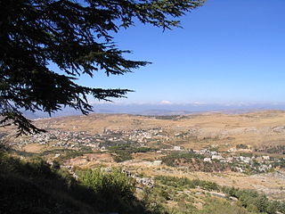
WSawfar, also spelled as Saoufar or Sofar) is a village in the Aley District of the Mount Lebanon Governorate in Lebanon. It is situated at an altitude of 1,320 meters and next to the main road linking Beirut with Damascus in Syria.