 W
WAdmiralty Arch, located in Holyhead, Anglesey, was built in 1824 to mark the end of Thomas Telford's Holyhead road. The arch was designed by Thomas Harrison and its main purpose was to commemorate the visit of King George IV of the United Kingdom in August 1821. The King arrived in Holyhead on the royal yacht Royal George on the 7 August, continuing to Plas Newydd where he stopped overnight. He returned the next day to his yacht, but due to poor weather his departure was delayed and the decision was made to transfer to the steam packet Lightning which conveyed him on the 12 August to Howth, near Dublin for his state visit to Ireland. The change to the packet boat was met with widespread approval.
 W
WAran Fawddwy is a mountain in southern Snowdonia, Wales, United Kingdom. It is the highest point of the historic county of Merionethshire. It is the only peak in Wales outside North Snowdonia above 900m, and higher than anywhere in Great Britain outside Northern Snowdonia, the Scottish Highlands and the Lake District. The nearest urban centres to the mountain are Dinas Mawddwy to the south, Llanymawddwy to the southeast, Llanuwchllyn on the shores of Bala Lake to the north, and Rhydymain to the west. The nearest settlements with around 2,000 people are Bala and Dolgellau. On the eastern slopes of Aran Fawddwy is the small lake named Creiglyn Dyfi, the source of the River Dyfi. Its sister peak is Aran Benllyn at 885 metres (2,904 ft). There is also a middle peak- Erw y Ddafad-ddu.
 W
WCadair Idris or Cader Idris is a mountain in the historic county of Merionethshire, Wales. It lies at the southern end of the Snowdonia National Park near the town of Dolgellau. The peak, which is one of the most popular in Wales for walkers and hikers, is composed largely of Ordovician igneous rocks, with classic glacial erosion features such as cwms, moraines, striated rocks, and roches moutonnées.
 W
WCarnedd Llewelyn, usually spelt Carnedd Llywelyn in Welsh, is a mountain massif in the Carneddau range in Snowdonia, north-west Wales. It is the highest point of the Carneddau and the second highest peak by relative height in Wales, 49th in the British Isles and lies on the border between Gwynedd and Conwy.
 W
WCastell Coch is a 19th-century Gothic Revival castle built above the village of Tongwynlais in South Wales. The first castle on the site was built by the Normans after 1081, to protect the newly conquered town of Cardiff and control the route along the Taff Gorge. Abandoned shortly afterwards, the castle's earth motte was reused by Gilbert de Clare as the basis for a new stone fortification, which he built between 1267 and 1277 to control his freshly annexed Welsh lands. This castle was likely destroyed in the native Welsh rebellion of 1314. In 1760, the castle ruins were acquired by John Stuart, 3rd Earl of Bute, as part of a marriage settlement that brought the family vast estates in South Wales.
 W
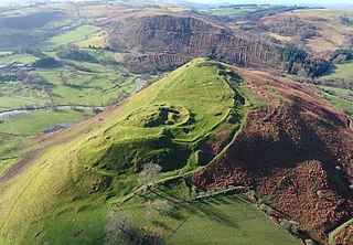
WCefnllys Castle was a medieval spur castle in Radnorshire, Wales. Two successive masonry castles were built on a ridge above the River Ithon known as Castle Bank in the thirteenth century, replacing a wooden motte-and-bailey castle constructed by the Normans nearby. Controlling several communication routes into the highlands of Mid Wales, the castles were strategically important within the Welsh Marches during the High Middle Ages. As the seat of the fiercely contested lordship and cantref of Maelienydd, Cefnllys became a source of friction between Llywelyn ap Gruffudd and Roger Mortimer in the prelude to Edward I's conquest of Wales. Cefnllys was also the site of a borough and medieval town.
 W
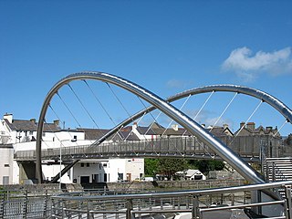
WThe Celtic Gateway is a stainless steel pedestrian and cycle bridge located in Anglesey, Wales. Opened on 19 October 2006 by Andrew Davies AM to better connect Holyhead's railway station and ferry terminal with the town centre for pedestrians and cyclists. The distance between the two was originally 830 metres, including two steep inclines and the crossing of a busy road. A 1991 bridge reduced the distance to 585 metres with one steep incline but with the road crossing still needed. The current bridge has one shallow incline and cuts the distance to 280 metres with no roads to cross.
 W
WCorn Du is a summit of the twin topped Pen y Fan and the second highest peak in South Wales at 873 m, situated in the Brecon Beacons National Park. The summit itself is marked by a well structured Bronze Age cairn with a central burial cist like that on nearby Pen y Fan. The two summits are visible from great distances owing to their height above the surrounding moorland, and are famous landmarks. The views from the peaks are also panoramic and very extensive, the Black Mountain and Fforest Fawr being especially obvious to the west. Mynydd Epynt is visible to the north behind the county town of Brecon, and other parts of the escarpment to the east.
 W
WCraig-y-nos Castle, is a Victorian-Gothic country house in Powys, Wales, United Kingdom. Built on parkland beside the River Tawe in the upper Swansea Valley, it is located on the southeastern edge of the Black Mountain. The castle, formerly owned by opera singer Adelina Patti, is now a boutique hotel, catering, conferencing and entertainment venue. Adjoining the castle are its landscaped grounds which now serve as a country park, managed separately by the Brecon Beacons National Park Authority.
 W
WThe Elvis Rock is a rock alongside the A44 in Powys, Wales, near its border with Ceredigion.It is one of the most well known pieces of graffiti in Wales, with the word "ELVIS" written on it. The rock is located beside the main trunk road through the country, and appears out of context with the surrounding landscape.
 W
WGlyder Fawr is a mountain in Snowdonia, Wales, the highest peak in the Glyderau range at just over 1,000 metres, having had its height recalculated in 2010 using GPS. It is the fifth-highest mountain in Wales and has several walking and scrambling routes leading to its summit. According to Sir Ifor Williams, the word "Glyder" derives from the Welsh word "Gludair", meaning a heap of stones.
 W
WAll Saints' Church stands in the former coal mining village of Gresford in Wrexham County Borough, Wales. It is a large, mainly late 15th-century church in a slightly red sandstone, in many ways more typical of nearby Cheshire churches. It has been described as the finest parish church in Wales, and has the most surviving medieval stained glass of any Welsh church.
 W
WLlangollen is a town and community in Denbighshire, Wales. It is situated on the River Dee at the edge of the Berwyn range and the Dee Valley Way AONB. It had a population of 3,658 at the 2011 census.
 W
WThe Menai Suspension Bridge is a suspension bridge to carry road traffic between the island of Anglesey and the mainland of Wales. The bridge was designed by Thomas Telford and completed in 1826 and is a Grade I listed structure.
 W
WMynydd Cambergi or Mynydd Cam-bergi is a mountain in southern Snowdonia, Wales. It is a summit on a long ridge between Mynydd y Waun to the north and Foel Grochan to the east. The mountain forms the north-east side of Cwm Hengae and sits about 0.5 miles (0.80 km) west of the village of Aberangell.
 W
WMynydd Dolgoed or Craig Portas is a mountain in southern Snowdonia, Wales. It is a long ridge running from a low summit between the valleys of the Afon Angell and the Nant Ceiswyn, north east to the cliff of Craig Portas above Dinas Mawddwy.. The next mountain in the ridge to south-east is Mynydd Hendre-ddu, while to the south lie Mynydd Llwydiarth and Mynydd Cymerau.
 W
WMynydd Gartheiniog is a mountain in southern Snowdonia, Wales. It is a long ridge running south from the cliff of Craig Portas above Dinas Mawddwy and parallel to Mynydd Dolgoed which lies to the west.
 W
WMynydd Hendre-ddu or Mynydd Hendreddu is a mountain in southern Snowdonia, Wales. It is one of a line of mountains running from Mynydd Dolgoed in the north, through Mynydd Llwydiarth to Mynydd Hendre-ddu and on to Mynydd y Foel, Y Grug, Mynydd Tri-Arglwyd and Mynydd Gwyn to the south of the village of Aberangell. It forms the watershed between Nant Llwydiarth, which flows to the south-west and into the Afon Dulas, and streams flowing into Afon Angell to the north, which flow east into the River Dyfi.
 W
WMynydd Llwydiarth is a mountain in southern Snowdonia, Wales. It is a long ridge running from a low summit to the south of Mynydd Dolgoed, running south-west to Mynydd Cymerau. Nant Llwydiarth rises on the south flank of the mountain, and on the west slope the Ratgoed slate quarry operated until 1946.
 W
WMynydd Llwyn-gwern or Mynydd Llwyngwern is a mountain in southern Snowdonia, Wales. It lies above the Afon Dulas to the west and the Nant Ffrydlan to the east. The summit is noted for a series of low pillow mounds.
 W
WOverton or Overton-on-Dee is a small town and a local government community, the lowest tier of local government, part of Wrexham County Borough in Wales. It is situated close to the Welsh-English border on the edge of an escarpment that winds its way around the course of the River Dee, from which Overton-on-Dee derives its name.
 W
WPen y Fan is the highest peak in south Wales, situated in the Brecon Beacons National Park. At 886 metres (2,907 ft) above sea-level, it is also the highest British peak south of Cadair Idris in Snowdonia. It is the highest point of the historic county of Brecknockshire. The twin summits of Pen y Fan and Corn Du at 873 m were formerly referred to as Cadair Arthur or 'Arthur's Seat'.
 W
WPistyll Rhaeadr is a waterfall 4 miles from the village of Llanrhaeadr-ym-Mochnant in Powys, Wales and 16 miles west of Oswestry.
 W
WThe Pontcysyllte Aqueduct is a navigable aqueduct that carries the Llangollen Canal across the River Dee in the Vale of Llangollen in northeast Wales.
 W
WThe Second Severn Crossing —officially renamed the Prince of Wales Bridge —is the M4 motorway bridge over the River Severn between England and Wales, inaugurated on 5 June 1996 by the Prince of Wales to supplement the traffic capacity of the Severn Bridge built in 1966. The bridge is operated by Highways England. In 2018 the bridge was renamed the Prince of Wales Bridge.
 W
WThe Seven Wonders of Wales is a traditional list of notable landmarks in north Wales, commemorated in an anonymously written rhyme:Pistyll Rhaeadr and Wrexham steeple, Snowdon's mountain without its people, Overton yew trees, St Winefride's well, Llangollen bridge and Gresford bells.
 W
WThe Severn Bridge is a motorway suspension bridge operated by Highways England that spans the River Severn and River Wye between Aust, Southern Gloucestershire in England, and Chepstow, Monmouthshire in South East Wales, via Beachley, Gloucestershire, which is a peninsula between the two rivers. It is the original Severn road crossing between England and Wales, and took three-and-a-half years to construct at a cost of £8 million. It replaced the Aust Ferry.
 W
WSnowdon is the highest mountain in Wales, at an elevation of 1,085 metres (3,560 ft) above sea level, and the highest point in the British Isles outside the Scottish Highlands. It is located in Snowdonia National Park in Gwynedd. It is the busiest mountain in the United Kingdom and the third most visited attraction in Wales; in 2018 it was visited by 558,000 walkers, with an additional 140,000 people taking the train. It is designated as a national nature reserve for its rare flora and fauna.
 W
WSt Winefride's Well is a well located in the village of Holywell, Flintshire, in Wales. It claims to be the oldest continually visited pilgrimage site in Great Britain and is a grade I listed building and scheduled ancient monument. St Winefride's well is believed to be connected to St Mary's well and chapel in Cefn Meiriadog, Denbighshire. It is one of the few locations mentioned by name in the anonymous medieval alliterative poem Sir Gawain and the Green Knight.
 W
WSugar Loaf, sometimes called The Sugar Loaf, is a prominent hill in Carmarthenshire, Wales beside the A483 trunk road some 4 miles (6.4 km) south-west of Llanwrtyd Wells. It is a popular viewpoint and picnic spot within easy reach on foot from the roadside car parks to the northeast and to the south. There is a stop on the nearby Heart of Wales Line called Sugar Loaf railway station.
 W
WSugar Loaf, sometimes called The Sugar Loaf, is a mountain situated 2 miles (3.2 km) north-west of Abergavenny in Monmouthshire, Wales and sits within the Brecon Beacons National Park. It is the southernmost of the summit peaks of the Black Mountains, with a height of 1,955 feet (596 metres).
 W
WTintern Abbey was founded on 9 May 1131 by Walter de Clare, Lord of Chepstow. It is situated adjacent to the village of Tintern in Monmouthshire, on the Welsh bank of the River Wye, which at this location forms the border between Monmouthshire in Wales and Gloucestershire in England. It was the first Cistercian foundation in Wales, and only the second in Britain.
 W
WTwmbarlwm, also known as Twm Barlwm, Twyn Barlwm or locally known as "the Twmp", the Nipple or the Pimple because of the mound that lies at its summit, is a hill situated 2 km (1.2 mi) to the northeast of Risca in South Wales. It is often mistakenly referred to as a mountain but is actually a hill due to being under 600 m (2,000 ft). It is 419 m (1,375 ft) high and is a well-known landmark throughout the region. It commands extensive views across what is now the M4 corridor, over Newport and Cwmbran - with part of it coming into Cwmbran - and out over the Bristol Channel.
 W
WValle Crucis Abbey is a Cistercian abbey located in Llantysilio in Denbighshire, Wales. More formally the Abbey Church of the Blessed Virgin Mary, Valle Crucis it is known in Welsh both as Abaty Glyn Egwestl and Abaty Glyn y Groes. The abbey was built in 1201 by Madog ap Gruffydd Maelor, Prince of Powys Fadog. Valle Crucis was dissolved in 1537 during the Dissolution of the Monasteries, and subsequently fell into serious disrepair. The building is now a ruin, though large parts of the original structure still survive. Valle Crucis Abbey is now under the care of Cadw. The abbey received 5,690 visitors in 2018.
 W
WWaun Fach is, with a summit height of 811 metres (2,661 ft), the highest mountain in the Black Mountains in south-eastern Wales. It is one of the three Marilyns over 600m that make up the range, the others being Black Mountain and Mynydd Troed. To the north Rhos Fawr and the Radnor Forest can be seen. It is the second highest mountain in Britain south of Snowdonia. It is situated at the head of the Grwyne Fechan valley, above and to the west of the Grwyne Fawr reservoir. It has an undistinguished rounded summit. The nearby tops on the ridge, Pen Trumau and Pen y Gadair Fawr, although lower, are very much more recognisable.
 W
WSt Giles' Parish Church is the parish church of Wrexham, Wales. The church is recognised as one of the finest examples of ecclesiastical architecture in Wales and is a Grade I listed building, described by Sir Simon Jenkins as 'the glory of the Marches' and by W. D. Caröe as a 'glorious masterpiece'.