 W
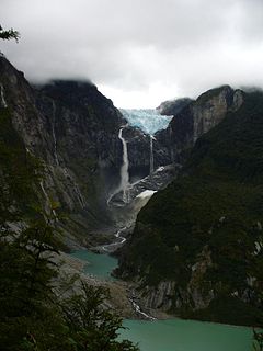
WAlberto de Agostini National Park is a protected area that was created on January 22, 1965, on land that was formerly part of the "Hollanda" forest reserve and "Hernando de Magallanes National Park". It covers 1,460,000 hectares and includes the Cordillera Darwin mountain range, which is the final land-based stretch of the Andes before it becomes a chain of mountains appearing as small islands that sink into the Pacific Ocean and the Beagle Channel.
 W
WAlerce Andino National Park is located in the Andes, in Los Lagos Region of Chile. This national park covers about 393 km². It is bounded by the Reloncaví Estuary on its east and south sides, and by the Reloncaví Sound to the west. To its north lies Chapo Lake.
 W
WAlerce Costero National Park is a protected wild area in the Cordillera Pelada about 137 km from Valdivia and 49 km from La Unión. Fitzroya trees grow inside the protected area and give the area its name, with Alerce Costero translating as Coastal Fitzroya. The Natural Monument has a total area of 137 hectares.
 W
WAlto Loa National Reserve is a Protected Area located in the province of El Loa, Antofagasta region, Chile. Announced in 2002 and created in 2005, it is Chile's largest natural reserve.
 W
WArchipiélago de Juan Fernández National Park is a national park located in the Pacific Ocean 665 kilometres west of Chile's mainland port of San Antonio, in the Juan Fernández Archipelago. The park covers 96 square kilometres and comprises the Santa Clara, Alejandro Selkirk and the most part of the Robinson Crusoe Island islands.
 W
WBernardo O'Higgins National Park is the largest of the protected areas in Chile, covering an area of 3,525,901 ha in both the Aysén and Magallanes and Antártica Chilena regions. Management of this and other national parks in Chile is entrusted to the Corporación Nacional Forestal (CONAF). The park is named after General Bernardo O'Higgins, the first head of state of the Republic of Chile. Los Glaciares National Park (Argentina) and Torres del Paine National Park are its neighbours to the east, Laguna San Rafael National Park is located to the north, the Alacalufes National Reserve to the southwest and the Katalalixar National Reserve to the northwest.
 W
WBosque de Fray Jorge national park or Bosque Fray Jorge national park lies in the Limarí Province, Coquimbo Region, Chile. It is a UNESCO Biosphere reserve. Management of this and other national parks in Chile is entrusted to Corporacion Nacional Forestal, CONAF.
 W
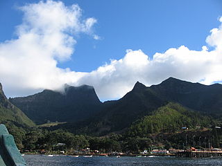
WCabo de Hornos National Park is a protected area in southern Chile that was designated a Biosphere Reserve by UNESCO in 2005, along with Alberto de Agostini National Park. The world's southernmost national park, it is located 12 hours by boat from Puerto Williams in the Cape Horn Archipelago, which belongs to the Commune of Cabo de Hornos in the Antártica Chilena Province of Magallanes y Antártica Chilena Region.
 W
WChiloé National Park is a national park of Chile, located in the western coast of Chiloé Island, in Los Lagos Region. It encompasses an area of 430.57 km2 (166 sq mi) divided into two main sectors: the smallest, called Chepu, is in the commune of Ancud, whereas the rest, called Anay, is in the communes of Dalcahue, Castro and Chonchi. The greater portion of the Park is in the foothills of Chilean Coastal Range, known as the Cordillera del Piuchén. It includes zones of dunes, Valdivian temperate rain forests, swamps, and peat bogs. A small portion, Metalqui, is an islet with an area of 0.5 km2 (0.19 sq mi). It is located between 42° 07' and 42° 13' south latitude and between 73° 55' and 74° 09' west longitude.
 W
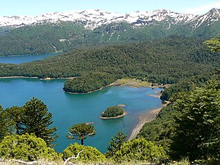
WConguillío National Park is located in the Andes, in the provinces of Cautín and Malleco, in the Araucanía Region of Chile also known as Region IX. Its name derives from the Mapuche word for "water with Araucaria seeds".
 W
WCorcovado National Park is an 2,940-square-kilometre (726,000-acre) preserved area of Valdivian temperate rainforest, high peaks, alpine lakes, and rivers in Chile's Los Lagos Region. This coastal park borders the Gulf of Corcovado to the west and includes the iconic volcanoes Corcovado and Yanteles. This preserved area has no public access infrastructure.
 W
WHornopirén National Park is located in the Andes, in the Palena Province of Chile's Los Lagos Region, also known as Region X. The park contains 482 km2 (186 sq mi) of rugged mountains and unspoiled Valdivian temperate rain forests. This national park borders the northern portion of Pumalín Park. The Carretera Austral passes close to the park. In the vicinity of the park lie Hornopirén and Yate volcanoes.
 W
WSalar del Huasco is a salt flat dotted with ponds and salt marshes, and seasonally partially covered with water, in northern Chile. It is the centerpiece of the recently created Salar del Huasco National Park and was designated Ramsar Site 874 on 2 December 1996. The area has a significant population of flamingos.
 W
WHuerquehue National Park is located in the foothills of the Andes, in the Valdivian temperate rainforest of the La Araucanía region in southern Chile. It lies 145 km southeast of Temuco and 33 km east of Pucón, between the Villarrica National Reserve to the west and the Hualalafquén National Reserve to the east. The park encompasses 125 square kilometres of mountainous terrain east of Caburgua Lake, and has an elevation range of 720 to 2,000 m asl.
 W
WThe Isla Magdalena national park is a 1,576 km2 (608 sq mi) protected area in Magdalena Island, Patagonia, Chile. It was created in 1967 as Forest Reserve and was reclassified as a National Park in 1983.
 W
WLa Campana National Park is located in the Cordillera de la Costa, Quillota Province, in the Valparaíso Region of Chile. La Campana National Park and the Vizcachas Mountains lie northwest of Santiago. This national park covers approximately 80 square kilometres (31 sq mi) and is home to one of the last palm forests of Jubaea chilensis, which prehistorically had a much wider distribution than at present. Another attraction is the Cerro La Campana, which lends its name to the park. In 1834 Charles Darwin climbed this mountain, during the second voyage of HMS Beagle.
 W
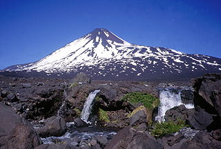
WLaguna del Laja National Park is a national park of Chile located in the Andes, between 37°22’ and 37°28’ south latitude and 71°16’ and 71°26’ west longitude.
 W
WLaguna San Rafael National Park is a park located on the Pacific coast of southern Chile. The park is named for the San Rafael Lagoon formed by the retreat of the San Rafael Glacier. Created in 1959, it covers an area of 17,420 km2 (6,726 sq mi) and includes the Northern Patagonian Ice Field. A fjord more than 16 km (10 mi) long is one of the park's principal attractions.
 W
WLas Palmas de Cocalán National Park is located in the Cordillera de la Costa, Cachapoal Province, in the Libertador General Bernardo O'Higgins Region of Chile.
 W
WLauca National Park is located in Chile's far north, in the Andean range. It encompasses an area of 1,379 km2 of altiplano and mountains, the latter consisting mainly of enormous volcanoes. Las Vicuñas National Reserve is its neighbour to the south. Both protected areas, along with Salar de Surire Natural Monument, form Lauca Biosphere Reserve. The park borders Sajama National Park in Bolivia.
 W
WLlanos de Challe National Park is located on the Pacific coast of the Atacama Region, Chile. The park's mountains are moistened by the Camanchaca, creating a fog and mist-fed ecosystem called lomas. The park is one of the southernmost locations of the lomas which are scattered along the coastal desert from northern Chile to northern Peru. The highest elevation in the park is Cerro Negro at 950 m.
 W
WLlullaillaco National Park is a national park of Chile, located 275 km southeast of Antofagasta in the Andes. It lies between the eastern slopes of the Cordillera Domeyko and the international border with Argentina. In the park there are several important mountains that culminate at the summit of Llullaillaco volcano. The park also is characterized by extensive semi-desert plains interspersed by Quebradas. A part of the Inca road system is found in Río Frío area.
The National Forest Corporation or CONAF is a Chilean private, non-profit organization, through which the Chilean state contributes to the development and sustainable management of the country's forest resources. CONAF is overseen and funded by the Ministry of Agriculture of Chile.
 W
WNevado Tres Cruces National Park is a national park located in the Atacama Region of Chile, east of Copiapó. It includes Laguna Santa Rosa, Laguna del Negro Francisco, and a part of the Salar de Maricunga. The park is divided into two zones, the northern zone encompassing the southern portion of Salar de Maricunga and Laguna Santa Rosa, and the southern area the Laguna del Negro Francisco. The park is named after Nevado Tres Cruces, which dominates the landscape of the area. The park is managed by the Corporación Nacional Forestal, which offers two refuges in the area: one at the south of Negro Francisco Lagoon and other at the west of Santa Rosa Lagoon. The park is open from October to April.
 W
WThe Pali-Aike National Park is a park located in the Magallanes Region of the Chilean Patagonia. Pali-Aike is a Tehuelche name that means Desolate Place. Created in 1970, it covers an area of 5,030 hectares and includes part of the Pali-Aike Volcanic Field. The park draws its name from a prominent volcanic cone known as the Pali Aike Crater. Human crania from early prehistoric occupation have been recovered from this Pali Aike Crater site. It includes native flora and faunal, with some species being exclusive to the region and cannot be found anywhere else in the world. The park has many rocky formations covered in 1000 years old larva.
 W
WPan de Azúcar National Park is a national park of Chile. The park straddles the border between the Antofagasta Region and the Atacama Region. Its name, Parque Nacional Pan de Azúcar, means "sugar loaf national park".
 W
WPuyehue National Park is located in the Andes mountain range, in Los Ríos and Los Lagos regions of Chile formerly referred to as the 10th region. The park boast 220,000 acres of natural thermal springs, volcanoes, and evergreen forests, after having been expanded in 1950 and 1981. The park is Chile's most visited national park with 400,000 people enjoying it each year. Puyehue National park forms part of the Reserve of Temperate Rainy Forest Biospheres of the Southern Andes. Chile Route 215 passes through the park, which connects with the Argentine Route 231 via Cardenal Antonio Samoré Pass.
 W
WQueulat National Park is a national park of Chile located in the Aysén del General Carlos Ibáñez del Campo Region. The park is bordered by the Cisnes River on the south side and is neighbor to Lago Rosselot National Reserve. It contains 1,541 km2 (595 sq mi) of glacier-capped mountains and virgin evergreen forests.
 W
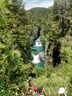
WRadal Siete Tazas National Park is a national park located in Curicó Province, Maule Region, Chile. It lies in a pre-Andean area close to Descabezado Grande volcano.
 W
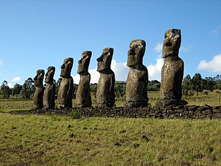
WRapa Nui National Park is a national park and UNESCO World Heritage Site located on Easter Island, Chile. Rapa Nui is the Polynesian name of Easter Island; its Spanish name is Isla de Pascua. The island is located in the southeastern Pacific Ocean, at the southeastern extremity of the Polynesian Triangle. The island was taken over by Chile in 1888. Its fame and World Heritage status arise from the 887 extant stone statues known by the name "moai", whose creation is attributed to the early Rapa Nui people who inhabited the island around 300 AD. Much of the island has been declared as Rapa Nui National Park which, on 22 March 1996, UNESCO designated a World Heritage Site under cultural criteria (i), (iii), & (v). The Rapa Nui National Park is now under the administrative control of the Ma´u Henua Polynesian Indigenous Community, which is the first autonomous institute on the island. The indigenous Rapa Nui people have regained authority over their ancestral lands and are in charge of the management, preservation and protection of their patrimony. On the first of December 2017, the ex-President Michelle Bachelet returned ancestral lands in the form of the Rapa Nui National Park to the indigenous people. For the first time in history, the revenue generated by the National Park is invested in the island and used to conserve the natural heritage.
 W
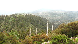
WTolhuaca National Park is a Protected Area created on October 16, 1935, in an area of 3,500 ha that was previously part of the Malleco National Reserve. In 1985, a second section of Malleco National Reserve was also made part of the national park. Malleco National Reserve was the first protected wildlife area in both Chile and South America, so the land within Tolhuaca National Park is one of the oldest protected areas on the continent.
 W
WTorres del Paine National Park is a national park encompassing mountains, glaciers, lakes, and rivers in southern Chilean Patagonia. The Cordillera del Paine is the centerpiece of the park. It lies in a transition area between the Magellanic subpolar forests and the Patagonian Steppes. The park is located 112 km (70 mi) north of Puerto Natales and 312 km (194 mi) north of Punta Arenas. The park borders Bernardo O'Higgins National Park to the west and the Los Glaciares National Park to the north in Argentine territory. Paine means "blue" in the native Tehuelche (Aonikenk) language and is pronounced PIE-nay, while Torres means "towers".
 W
WVicente Pérez Rosales National Park is located in Los Lagos Region, Llanquihue Province, of Chile. Its western entrance is close to the Ensenada locality, 82 km (51 mi) northeast of the provincial capital of Puerto Montt, and 64 km (40 mi) from Puerto Varas along Ruta CH-225. This national park covers about 2,530 km2 (977 sq mi) and is almost entirely in the Andes mountain chain. The adjacent national parks Vicente Pérez Rosales and Puyehue National Park in Chile, and Nahuel Huapi National Park and Lanín National Park in Argentina, provide a continuous protected area of close to 15,000 km2 (5,792 sq mi).
 W
WVillarrica National Park is located in the Andes, in the La Araucanía and Los Ríos regions of Chile, near Pucón. The centerpiece of the park is a line of three volcanoes stretching transversely to the Andean range: Villarrica, Quetrupillán, and Lanín. Other mountains in the park include Quinquilil volcano, also known as Colmillo del Diablo, and Cerro Las Peinetas, which lies on the border between Argentina and Chile. It ranges in elevation from 600 m (1,969 ft) to 3,776 m (12,388 ft) at Lanín Volcano.
 W
WVolcán Isluga National Park is located in the Andes, in the Tarapacá Region of Chile, near Colchane and south of Lauca Biosphere Reserve. It covers 1,747 square kilometers, with elevations ranging between 2,100 and 5,550 meters. It is named after Volcán Isluga, which at 5,550 m, is the tallest mountain in this park.
 W
WYendegaia National Park is located in Tierra del Fuego in the Magallanes y la Antártica Chilena Region of Chile and contains 150,612 ha of mountainous terrain and Valdivian temperate rain forest. It borders the Alberto de Agostini National Park and Tierra del Fuego National Park.