 W
WJohn Ainslie was a Scottish surveyor and cartographer.
 W
WJosé Antonio de Alzate y Ramírez was a priest in New Spain, scientist, historian, cartographer, and journalist.
 W
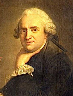
WJean Baptiste Bourguignon d'Anville was a geographer and cartographer who greatly improved the standards of map-making. His maps of ancient geography, characterized by careful, accurate work and based largely on original research, are especially valuable. He left unknown areas of continents blank and noted doubtful information as such; compared to the lavish maps of his predecessors, his maps looked empty.
 W
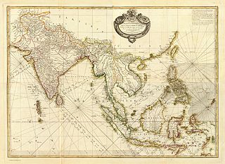
WJacques Nicolas Bellin was a French hydrographer, geographer, and member of the French intellectual group called the philosophes.
 W
WJean-Baptiste Berthier (1721–1804) was an officer (Lieutenant-Colonel) in the French Corps of Topographical Engineers during the reigns of Louis XV and Louis XVI.
 W
WRigobert Bonne was a French cartographer, widely considered to be one of the most important cartographers of the late 18th century.
 W
WEmanuel Bowen was a Welsh map engraver, who achieved the unique distinction of becoming Royal Mapmaker to both to King George II of Great Britain and Louis XV of France. Bowen was highly regarded by his contemporaries for producing some of the largest, most detailed and most accurate maps of his era. He is known to have worked with most British cartographic figures of the period including John Owen and Herman Moll.
 W
WPeter Perez Burdett was an 18th-century cartographer, surveyor, artist, and draughtsman originally from Eastwood in Essex where he inherited a small estate and the name Perez from his maternal grandfather who was the clergyman there. He would have been notable just for his many appearances in Joseph Wright's pictures but he was also involved with numerous projects including surveying the route for one of the major projects of the industrial revolution, the Leeds and Liverpool Canal, in 1769. He has been described as "if not in the centre at least in the penumbra of the Lunar Society of Birmingham". He spent the last years of his life in Karlsruhe, avoiding debtors, but still active in German society. His German daughter married a Count.
 W
WCésar-François Cassini de Thury, also called Cassini III or Cassini de Thury, was a French astronomer and cartographer.
 W
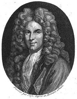
WGuillaume Delisle, also spelled Guillaume de l'Isle, was a French cartographer known for his popular and accurate maps of Europe and the newly explored Americas.
 W
WJohann Friedrich Endersch was a German cartographer and mathematician. Endersch also held the title of Royal Mathematician to King Augustus III of Poland.
 W
WNicolas de Fer was a French cartographer and geographer. He also was an engraver and publisher. His works focused more on quantity than quality, there were often geographical errors, and they were more artistic than accurate.
 W
WAlberto Fortis (1741–1803) was a Venetian writer, naturalist and cartographer.
 W
WJean-Baptiste-Louis Franquelin was born at Saint-Michel de Villebernin, France in 1650. He died in France around 1712. He was a cartographer, a royal hydrographer, and a teacher of navigation. He was also the first official cartographer in Canada.
 W
WTimote (Timothy) Gabashvili (1703–1764) was a Georgian travel writer, traveler, diplomat, cartographer, religious and public figure. He was the first to describe the Georgian antiquities of Jerusalem on his visit to the Holy Land in the 1750s.
 W
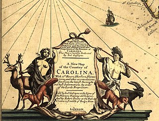
WJoel Gascoyne was an English nautical chartmaker, land cartographer and surveyor who set new standards of accuracy and pioneered large scale county maps. After achieving repute in the Thames school of chartmakers, he switched careers and became one of the leading surveyors of his day and a maker of land maps. He is best known for his maps of: the colonial Province of Carolina; of the county of Cornwall; and of the early 18th-century Parish of Stepney, precursor of today's East End of London. Gascoyne's distinctive style of chart and map-drawing was characterised by the use of bold and imaginative cartouches.
 W
WFelipe González de Ahedo, also spelled Phelipe González y Haedo, was a Spanish navigator and cartographer known for annexing Easter Island in 1770.
 W
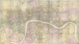
WRichard Horwood was a surveyor and cartographer. He is mainly remembered for his large-scale plan of London and its suburbs published in 32 sheets between 1792 and 1799. He also published a plan of Liverpool in six sheets in 1803.
 W
WThomas Jefferys, "Geographer to King George III", was an English cartographer who was the leading map supplier of his day. He engraved and printed maps for government and other official bodies and produced a wide range of commercial maps and atlases, especially of North America.
 W
WNicolaas Samuelszoon Kruik, also known as Klaas Kruik and Nicolaes Krukius, was a Dutch land surveyor, cartographer, astronomer and weatherman. He is commemorated by the Museum De Cruquius.
 W
WJacques-Barthélemy Micheli du Crest was a military engineer, physicist and cartographer, born in Geneva and so a citizen of the then Republic of Geneva, now in Switzerland. Born into the aristocracy, he eventually fled to France as an enemy of Geneva and eventually spent his later years in Aarburg Castle as a political prisoner. During his time there, he mapped the Alps accurately using rudimentary tools. One of his other major accomplishments whilst in exile was to create a thermometer and a temperature scale, which was commonly used in Switzerland and around Europe until it became obsolete in the 19th century.
 W
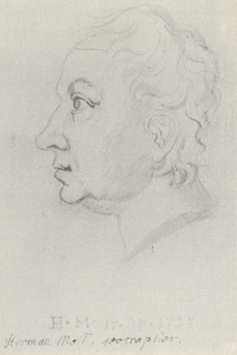
WHerman Moll was a London cartographer, engraver, and publisher.
 W
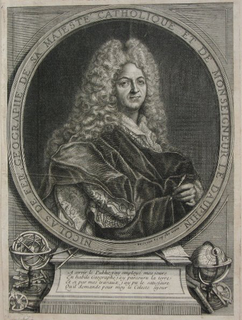
WJuan de la Cruz Cano y Olmedilla was a Spanish cartographer. For many years, Cano was the cartographer of the king Carlos III of Spain.
 W
WGeorge Perry was an English engineer, ironmaster, merchant, draughtsman and cartographer.
 W
WJohan Gustaf Renat (1682–1744) was a Swedish soldier and cartographer. He is primarily known for his role in bringing detailed maps of Central Asia to Europe after close to two decades in captivity.
 W
WJohn Rocque was a French-born British surveyor and cartographer, best known for his detailed map of London published in 1746.
 W
WAlexander Scammell was a Harvard educated attorney and an officer in the Continental Army during the American Revolutionary War. He was wounded on September 30, 1781, near Yorktown and subsequently died on October 6 in Williamsburg, Virginia, making him, a colonel, the highest ranking American officer killed during the Siege of Yorktown.
 W
WSamuel Graf von Schmettau was a Prussian field marshal, artilleryman and cartographer.
 W
WThe Sea of the West, or Mer de l'Ouest, was a geographic misconception of an inland sea in the Pacific Northwest that appeared on many maps of the 18th century. The depiction was particularly common on French maps. The sea was supposed to be connected to the Pacific Ocean by at least one strait. Many different conjectures about the sea's shape, size, and position appeared on maps of the period.
 W
WJohn Spilsbury was a British cartographer and engraver. He is credited as the inventor of the jigsaw puzzle. Spilsbury created them for educational purposes, and called them “Dissected Maps”. https://www.eschat.net
 W
WPhilip Johan von Strahlenberg (1676–1747) was a Swedish officer and geographer of German origin who made important contributions to the cartography of Russia.
 W
WDaniel-Charles Trudaine was a French administrator and civil engineer. Trudaine was one of the primary developers of the present French road system.
 W
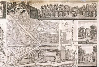
WMichel-Étienne Turgot was prévôt des marchands de Paris from 1729 to 1740. His name is associated with one of the most famous maps of Paris, the "Plan de Turgot", a detailed bird's-eye view of Paris realized by Louis Bretez from 1734 to 1739.
 W
WVakhushti (1696–1757) was a Georgian royal prince (batonishvili), geographer, historian and cartographer. His principal historical and geographic works, Description of the Kingdom of Georgia and the Geographical Atlas, were inscribed on UNESCO's Memory of the World Register in 2013.
 W
WGilles Robert de Vaugondy (1688–1766), also known as Le Sieur or Monsieur Robert, and his son, Didier Robert de Vaugondy (c.1723–1786), were leading cartographers in France during the 18th century.
 W
WRobert Wilkinson was an English map maker and atlas publisher.
 W
WAntonio Zatta was an Italian cartographer and publisher who was based in Venice. He may have lived from 1722 to 1804. One of his major contributions include the Atlante Novissimo, a four volume atlas of the world.