 W
WAdelaide Anchorage is an area of safe anchorage lying west of Avian Island, off the south end of Adelaide Island. It is the anchorage normally used by ships visiting Adelaide research station. Charted by members of the RRS John Biscoe and the Royal Navy Hydrographic Survey Unit in January–March 1962.
 W
WThe Amiot Islands are two groups of islands and rocks, the Ward Islands and Cumbers Reef, respectively, lying 17 kilometres (9 nmi) west of Cape Adriasola, Adelaide Island, Antarctica. They were discovered by the French Antarctic Expedition, 1908–10, and were named by Jean-Baptiste Charcot for A. Amiot, engineering director of the French Montevideo Co., Montevideo, Uruguay, which made repairs on the ship Pourquoi-Pas. The islands were more accurately charted by the British Royal Navy Hydrographic Survey Unit in 1963.
WAnchorage Island is an island lying 1.3 kilometres (0.7 nmi) south-east of Lagoon Island in the Léonie Islands, off the southeast coast of Adelaide Island. Discovered by the French Antarctic Expedition (FrAE), 1908–10. Named by the British Graham Land Expedition (BGLE) under Rymill, who visited the island in February 1936.
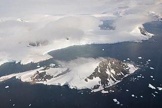
WAvian Island is an island, 1.2 km (0.7 mi) long and 40 metres (130 ft) high, lying close off the south tip of Adelaide Island, Antarctica. It was discovered by the French Antarctic Expedition, 1908–10, under Jean-Baptiste Charcot, and visited in 1948 by the Falkland Islands Dependencies Survey, who so named it because of the large number and variety of birds (avians) found there.
WThe Brockhamp Islands are two small islands in Laubeuf Fjord, lying 6 kilometres (3 nmi) southwest of Mothes Point, Adelaide Island. They were mapped by the Falkland Islands Dependencies Survey (FIDS) from Ronne Antarctic Research Expedition air photos, 1947–48, and FIDS surveys, 1948–50. They were named by the UK Antarctic Place-Names Committee for Bernhard Brockhamp, a German glaciologist who, with H. Mothes, made the first seismic soundings of a glacier, in Austria in 1926.
 W
WThe Chatos Islands are a group of small islands and rocks lying south of Cape Adriasola, Adelaide Island. The descriptive name Islotes Chatos was given by the Argentine Antarctic Expedition of 1952–53.
 W
WCole Channel is a marine channel running north–south between Wright Peninsula, Adelaide Island, and Wyatt Island, Laubeuf Fjord, off the Loubet Coast, Antarctica. It was named by the UK Antarctic Place-Names Committee in 1984 after Captain Maurice John Cole, Senior Master of the British Antarctic Survey ship Bransfield from 1975. Cole did previous Antarctic service as an officer on the John Biscoe and the Shackleton, for several seasons between 1960 and 1972.
WCono Island is a conspicuous conical island lying south of the Chatos Islands, off the southwest part of Adelaide Island. The feature was descriptively named Islote Cono by the Argentine Antarctic Expedition of 1952–53.
WDewar Nunatak is a mainly snow-covered nunatak rising to 520 metres (1,700 ft) in the middle of Shambles Glacier, on the east coast of Adelaide Island. It was named by the UK Antarctic Place-Names Committee in 1963 for Graham J.A. Dewar, a British Antarctic Survey geologist at Adelaide station, 1961–63.
WThe Dion Islands are a group of small islands and rocks lying in the northern part of Marguerite Bay, 11 kilometres (6 nmi) south-west of Cape Alexandra, Adelaide Island, off the west coast of the Antarctic Peninsula. They were discovered by the French Antarctic Expedition, 1908–10, and named by Jean-Baptiste Charcot for the Marquis Jules-Albert de Dion, who donated three motor sledges and whose De Dion-Bouton works produced equipment for the expedition.
WThe Embassy Islands are two small islands, the westernmost of the Dion Islands, lying 13 kilometres (7 nmi) south of Adelaide Island. The Dion Islands were first sighted and roughly charted in 1909 by the French Antarctic Expedition under Jean-Baptiste Charcot. This feature was surveyed in 1949 by the Falkland Islands Dependencies Survey and named "Embassy Rock" by the UK Antarctic Place-Names Committee because of its detached position in association with Emperor Island. In 1963 the British Royal Navy Hydrographic Survey Unit found there were two islands, not one as previously supposed.
WThe Esplin Islands are a group of two small islands and off-lying rocks lying northeast of Box Reef, off the south end of Adelaide Island. They were named by the UK Antarctic Place-Names Committee for Sub. Lieutenant Christopher J. Esplin Jones, Royal Navy, a member of the Royal Navy Hydrographic Survey Unit which charted this group in 1962–63.
WMount Gaudry is a mountain, 2,315 metres (7,600 ft) high, rising close southwest of Mount Barre and 5 nautical miles (9 km) north-northwest of Mount Liotard in the southern part of Adelaide Island, Antarctica. It was discovered by the French Antarctic Expedition, 1903–05, under Jean-Baptiste Charcot, who named it after Albert Gaudry, a prominent French paleontologist.
WThe Ginger Islands are a group of islands lying west of Cape Alexandra, off the southern end of Adelaide Island, Antarctica. The largest of the islands appears reddish when free of snow. They were surveyed by the Royal Navy's hydrographic survey unit in 1962-63 and named by the United Kingdom Antarctic Place-Names Committee (UK-APC) for Kenneth Ginger, Civil Hydrographic Officer responsible for British Admiralty charts of the Antarctic for several years beginning in 1958.
WThe Henkes Islands are a group of small islands and rocks 4 kilometres (2 nmi) in extent, lying 2 kilometres (1 nmi) southwest of Avian Island, close off the southern extremity of Adelaide Island, Antarctica. The islands were discovered by the French Antarctic Expedition, 1908–10, under Jean-Baptiste Charcot, and named by him for one of the Dutch directors of the Magellan Whaling Company at Punta Arenas. Charcot applied the name to the scattered rocks and islands between Cape Adriasola and Cape Alexandra, and the name was restricted to the group described by the UK Antarctic Place-Names Committee (UKAPC) following definitive mapping by the British Antarctic Survey (BAS) in 1961 and the British Royal Navy Hydrographic Survey (BRNHS) in 1963. All of the islands in the group were named by UKAPC.
 W
WHorton Glacier is a glacier at the east side of Mount Barre and Mount Gaudry, flowing southeast from Adelaide Island into Ryder Bay, Antarctica. It was named by the UK Antarctic Place-Names Committee in 1977 for Colin P. Horton, a British Antarctic Survey builder at the nearby Rothera Station, 1976–77.
WHurley Glacier is a glacier between Mount Gaudry and Mount Liotard, flowing east into Ryder Bay, Adelaide Island, Antarctica. It was named by the UK Antarctic Place-Names Committee in 1977 after Alec J. Hurley, a British Antarctic Survey mechanic at Halley Station, 1975–76, and Rothera Station, 1976–77.
 W
WJenny Island or Isla Juanita is a rocky island 3.7 km (2 nmi) long which rises to 500 m (1,600 ft), lying 5.6 km (3 nmi) east of Cape Alexandra, the southeastern extremity of Adelaide Island, in northern Marguerite Bay. Jenny Island is located at 67°44′S 68°24′W.
WKillingbeck Island is a small island lying east of Rothera Point, off the southeast coast of Adelaide Island, Antarctica. It was named by the UK Antarctic Place-Names Committee in 1964 for John B. Killingbeck, a British Antarctic Survey glaciologist in 1960–63.
WKirsty Island is an island in Ryder Bay, west of Lagoon Island and East of Léonie Island. I has outcrops of reddish rocks and is used by scientists at Rothera Research Station as a site for marine research and recreation. It is named for Kirsty Brown, a marine biologist with the British Antarctic Survey (BAS) who lost her life whilst snorkelling at Rothera Station in July 2003.
WKoechlin Island is an island off the northeast coast of Adelaide Island, Antarctica, about 8 kilometres (4.5 nmi) south of the Sillard Islands. It was mapped from air photos taken by the Ronne Antarctic Research Expedition (1947–48) and the Falkland Islands and Dependencies Aerial Survey Expedition (1956–57). The island was named by the UK Antarctic Place-Names Committee for Swiss glaciologist René Koechlin, author of Les glaciers et leur mechanisme, 1944.
WLagoon Island is the northernmost of the Léonie Islands, lying in the entrance to Ryder Bay on the southeast side of Adelaide Island, Antarctica. It was discovered by the French Antarctic Expedition, 1908–10, under Jean-Baptiste Charcot. The island was charted by the British Graham Land Expedition under John Rymill in February 1936 and was so named because with the island on its west side it forms a lagoon.
WLéonie Island is the largest and westernmost of the Léonie Islands, 2 kilometres (1 nmi) in diameter and 455 metres (1,500 ft) high, lying in the entrance to Ryder Bay along the southeast side of Adelaide Island, Antarctica. It was discovered and named by the French Antarctic Expedition, 1908–10, under Jean-Baptiste Charcot.
WThe Léonie Islands are a group of small islands lying in the entrance to Ryder Bay along the southeast side of Adelaide Island, Antarctica. The French Antarctic Expedition, 1908–10, under Jean-Baptiste Charcot, discovered these islands and gave the name Léonie Island to the largest island in the group. The British Graham Land Expedition under John Rymill, 1934–37, extended the coverage of the name to the entire group.
WLimpet Island is the southernmost of the Léonie Islands, Antarctica, lying in the entrance to Ryder Bay, close off the southeast coast of Adelaide Island. The Léonie Islands were discovered and first roughly surveyed in 1909 by the Fourth French Antarctic Expedition under Jean-Baptiste Charcot. Limpet Island was surveyed in 1948 by the Falkland Islands Dependencies Survey and so named by them because of the large number of limpet shells found there.
WLord Bank is a submarine bank in the Bellingshausen Sea with a least depth of 18 metres (60 ft) lying west-southwest of the entrance to Quest Channel, Adelaide Island, Antarctica. The bank was surveyed from HMS Endurance in January 1980 and was named by the UK Antarctic Place-Names Committee after Captain James Trevor Lord, Royal Navy, the commanding officer of HMS Endurance, 1978–80.
WMarguerite Bay or Margaret Bay is an extensive bay on the west side of the Antarctic Peninsula, which is bounded on the north by Adelaide Island and on the south by Wordie Ice Shelf, George VI Sound and Alexander Island. The mainland coast on the Antarctic Peninsula is Fallières Coast. Islands within the bay include Pourquoi Pas Island, Horseshoe Island, Terminal Island, and Lagotellerie Island. Marguerite Bay was discovered in 1909 by the French Antarctic Expedition under Jean-Baptiste Charcot, who named the bay for his wife.
WThe Mikkelsen Islands are a small group of islands and rocks lying off the southeast coast of Adelaide Island, 4 kilometres (2 nmi) southeast of the Léonie Islands. They were discovered by the French Antarctic Expedition under Jean-Baptiste Charcot in 1908–10 and named by him for Otto Mikkelsen, the Norwegian diver who inspected the damaged hull of the Pourquoi-Pas at Deception Island.
WShambles Glacier is a steep glacier 4 miles (6 km) long and 6 miles (10 km) wide, with very prominent hummocks and crevasses, flowing east between Mount Bouvier and Mount Mangin into Stonehouse Bay on the east side of Adelaide Island. It is the island's largest glacier, and provides an eastern outlet from the giant Fuchs Ice Piedmont which covers the entire western two-thirds of the island. In doing so, Shambles Glacier provides the largest 'gap' in Adelaide Island's north–south running mountain chain.
WSheldon Glacier is a glacier flowing southeast from Mount Mangin into Ryder Bay, Adelaide Island, Antarctica. Named by the United Kingdom Antarctic Place-Names Committee (UK-APC) in 1977 for Ernest B. Sheldon, British Antarctic Survey (BAS) meteorological observer, Adelaide Station, 1968–69, and Stonington Island, 1969–70; Base Commander, Adelaide Station, 1975–76, and Rothera Station, 1976–77.
WSighing Peak is a 640 m (2,100 ft) peak in Antarctica. It is located at the south side of the entrance to Stonehouse Bay on the east side of Adelaide Island. It was first sighted and surveyed in 1909 by the French Antarctic Expedition under Jean-Baptiste Charcot. It was resurveyed in 1948 by the Falkland Islands Dependencies Survey (FIDS) and so named by them because of the persistent sighing of wind from the summit of this peak, even when apparently calm at sea level.
WSloman Glacier is a glacier flowing between Mount Liotard and Mount Ditte to the southeast coast of Adelaide Island. Named by the United Kingdom Antarctic Place-Names Committee (UK-APC) in 1963 for William O. Sloman, British Antarctic Survey Personnel Officer for a number of years beginning in 1956.
WThe Stokes Peaks is a group of peaks rising to about 800 m between McCallum Pass and Sighing Peak on the north side of Wright Peninsula, Adelaide Island, Antarctica. They were photographed from the air by the Falkland Islands and Dependencies Aerial Survey Expedition (FIDASE), 1956–57, and surveyed by the British Antarctic Survey (BAS), in 1961–62. They were named by the United Kingdom Antarctic Place-Names Committee (UK-APC) in 1977 for Jeffrey C.A. Stokes, Falkland Islands Dependencies Survey (FIDS) assistant surveyor, Admiralty Bay, 1959–60, and Adelaide Island, 1960–61.
WStonehouse Bay is a bay in Antarctica on the west side of Laubeuf Fjord, indenting the east coast of Adelaide Island between Hunt Peak and Sighing Peak. The bay is 5 nautical miles (9 km) wide. It was first sighted and surveyed in January 1909 by the French Antarctic Expedition under Jean-Baptiste Charcot. The bay was named for Bernard Stonehouse of the Falkland Islands Dependencies Survey (FIDS), a meteorologist in 1947-48 and biologist in 1949 at Stonington Island and leader of the FIDS sledge party which resurveyed the bay in 1948.
WTurner Glacier is a glacier on the east side of Mount Liotard flowing northeast into Ryder Bay, Adelaide Island. The glacier was surveyed by Falkland Islands Dependencies Survey (FIDS), 1948, and photographed from the air by Falkland Islands and Dependencies Aerial Survey Expedition (FIDASE), 1956–57. Named by the United Kingdom Antarctic Place-Names Committee (UK-APC) in 1977 after Andrew John Turner, British Antarctic Survey (BAS) builder, Halley Station, 1973–74; Signy Island, 1974–75; Rothera Station, 1976–77, 1978–80; and Faraday Station, 1982–83.
 W
WWebb Island is a rocky island in Antarctica, 1.5 nautical miles (2.8 km) long, lying in Laubeuf Fjord about 3 nautical miles (6 km) south of the entrance to Stonehouse Bay, close to Adelaide Island. It was discovered by the French Antarctic Expedition under Jean Baptiste Charcot, 1908–10, and named by him for Captain Richard C. Webb of the Royal Navy, commanding officer of an English cruiser in Argentine waters at that time.
WWright Peninsula is a peninsula on the east coast of Adelaide Island, Antarctica, lying between Stonehouse Bay to the north and Ryder Bay to the south. On its northern coastline the peninsula is fringed by the Stokes Peaks; on its southern side by the Reptile Ridge. The Princess Royal Range separates the peninsula from the rest of Adelaide Island; the only 'gap' is provided by McCallum Pass.