 W
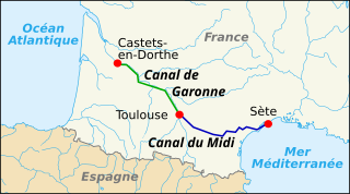
WThe Canal du Midi is a 240 km (150 mi) long canal in Southern France. Originally named the Canal royal en Languedoc and renamed by French revolutionaries to Canal du Midi in 1789, the canal was at the time considered one of the greatest construction works of the 17th century.
 W
WFrançois Andréossy (1633–1688) was a French engineer, cartographer, and a citizen of Narbonne. He was born in Paris on 10 June 1633. After completing his engineering studies in Paris, Andréossy went to Italy in 1660 to study Italian canal technology in Lombardy and Padua. He returned from the trip and sought out Pierre-Paul Riquet as a patron. Riquet was beginning his investigation into the possibility of building a canal across southern France from the Atlantic to the Mediterranean. Andréossy supplied the technical expertise that Riquet lacked and became Riquet's right-hand man throughout the construction of the canal.
 W
WAnjodi, was built to carry freight on the waterways of the Netherlands, Belgium and France but has been converted to a hotel barge.
 W
WNicolas Bachelier (1485–1557) was a French surveyor, architect, and sculptor who particularly worked in Toulouse.
 W
WThe Bassin de Lampy was created during 1777 and 1781 when a dam was placed on the Lampy Valley in the Aude department in south-central France. The reservoir provides a source of water for the Canal du Midi. It was originally proposed in 1665 by the commission created by Louis XIV of France to evaluate Pierre-Paul Riquet's plan for the canal enterprise.
 W
WThe Bassin de Naurouze is an octagonal holding tank, created during the building of the Canal du Midi as designed and built by Pierre-Paul Riquet. It was abandoned a few years after construction of the canal because of its recurrent silting problems. The flow of water from the Bassin de Saint-Ferréol joins the Canal du Midi at this point near the Seuil de Naurouze. Riquet hoped to build a city around the basin and also considered building a port. However, it easily filled with silt and its use discontinued. A lawn replaced the empty pool, and it is crossed by a straight path lined with plane trees.
 W
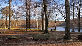
WThe Bassin de Saint-Ferréol was created as the result of a large earth dam across the mouth of the valley of Laudot stream at St. Ferréol in the Montagne Noire. It was originally proposed by Chevalier de Clerville and accepted by Pierre Paul Riquet as an integral part of the Canal du Midi. Riquet needed to provide a sufficient water reservoir to allow the locks to function year round, even in the dry summer season. The dam was begun on 15 April 1667 and was completed in four years. It was the first dam built specifically to supply water to a navigable canal and was by far the greatest single work of civil engineering undertaken during the building of the Canal du Midi.
 W
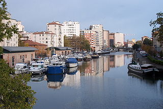
WThe Canal de Brienne is a French canal connecting the Garonne River with the Canal du Midi and the Canal de Garonne. It has two locks. The lock opening to the Garonne is known as Ecluse Saint-Pierre. The lock nearer to the Canal du Midi usually stands open.
 W
WThe Canal des Deux Mers has been used to describe two different but similar things since the 1660s. In some cases, it is used interchangeably with the Canal du Midi. In others, it describes the path from the Atlantic to the Mediterranean, of which the Canal du Midi was the first man-made component.
 W
WThe Canal de Garonne, formerly known as Canal latéral à la Garonne, is a French canal dating from the mid-19th century which connects Toulouse to Castets-en-Dorthe. The remainder of the route to Bordeaux uses the river Garonne. It is the continuation of the Canal du Midi which connects the Mediterranean with Toulouse.
 W
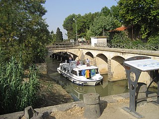
WThe Capestang bridge over the Canal du Midi at PK 189 at Capestang is a very important structure for those wishing to motor on the canal. It is used as a measuring device as it is the lowest structure on the canal. A boat, with an air draft under 3.3 m (11 ft) at the center and assuming a beam no more than 5 m (16 ft), a height of no more than 2.4 m (7.9 ft) at the extremities, should make it under the bridge. A British boat builder who builds boats for several of the boat hire companies in France builds their boats to meet these requirements.
 W
WThe Compagnie des chemins de fer du Midi, also known in English as the Midi or Southern Railway, was an early French railway company which operated a network of routes in the southwest of the country, chiefly in the area between its main line – which ran from Bordeaux, close to the Atlantic coast, to Sète on the Mediterranean – and the Pyrenees.
 W
WEnchanté is a Belgian-built barge of the spits category, originally named Maria, converted into a hotel barge. She is one of around 50 hotel barges operating on the French waterways.
 W
WSiphon sluices are one of the many water management devices used on the Canal du Midi to regulate the level of the water. The siphon acts as an automatic water level regulator. The épanchoir à siphon, or siphon sluice, was designed by Bertrand Garripuy (Garipuy) Jr., the son of the chief engineer. The first épanchoir siphon was built in 1776 near Capestang and the second in 1778 at Ventenac.
WSiphon sluices are one of the many water management devices used on the Canal du Midi to regulate the level of the water. The siphon acts as an automatic water level regulator. The épanchoir à siphon, or siphon sluice, was designed by Bertrand Garripuy (Garipuy) Jr., the son of the chief engineer. The first épanchoir siphon was built in 1776 near Capestang and the second in 1778 at Ventenac.
 W
WThe Fonserannes Water Slope, is a disused inclined plane on the Canal du Midi parallel to the Fonserannes Lock. It has a rise of 13.6 m (45 ft) and a slope of 5°.
 W
WThe Grand Bassin is the largest body of open water along the Canal du Midi. It is in Castelnaudary, France and covers some 7 hectares. Once a scene of intense economic activity, it is now a major pleasure port used by tourist craft. It holds the water reserve for the four locks of Saint-Roche.
 W
WThe La Nouvelle branch is a 37.3-kilometre (23.2 mi) branch of the Canal du Midi in Aude, southern France which runs from the Canal du Midi through Narbonne and on to the Mediterranean. It is made up of three waterways: the first 5.1 kilometres (3.2 mi) is the Canal de Jonction from the Canal du Midi to the Aude, the second section is 800 metres (2,625 ft) of the Aude itself and the third is the 31.6 kilometres (19.6 mi) Canal de la Robine which enters the Mediterranean at Port-la-Nouvelle. The La Nouvelle branch is designated a UNESCO World Heritage Site as part of the Canal du Midi and is managed by the French navigation authority, Voies navigables de France.
WThe Bassin de Lampy was created during 1777 and 1781 when a dam was placed on the Lampy Valley in the Aude department in south-central France. The reservoir provides a source of water for the Canal du Midi. It was originally proposed in 1665 by the commission created by Louis XIV of France to evaluate Pierre-Paul Riquet's plan for the canal enterprise.
 W
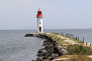
WThe Les Onglous Lighthouse is the terminating point of the Canal du Midi where the canal enters the Étang de Thau. The red and white lighthouse is at the tip of a short jetty projecting into the Étang de Thau. It is located on the east jetty at the canal entrance, about 1.5 km (0.93 mi) south of Marseillan in the Hérault department. The Isthmus of Onglous is a narrow strip of land between the Étang and the Mediterranean.
 W
WThe Malpas tunnel carries the Canal du Midi under the d'Ensérune hill in Hérault, France. Excavated in 1679, it was Europe's first navigable canal tunnel and is a monument to the determination of Pierre-Paul Riquet, the chief engineer. It is located in the commune of Nissan-lez-Ensérune near to the archaeological site Oppidum d'Ensérune.
 W
WOuvrages du Libron is a structure like no other on the Canal du Midi. It allows the Libron River, near Agde in south-west France, to traverse the Canal du Midi. At the point of intersection, the Libron is more or less at the same level as the Canal du Midi so a traditional aqueduct was not an option. The problem was further exacerbated by the Libron's propensity to flash flood up to twenty times a year. The problem was originally solved by the building of a pontoon aqueduct known as the Libron Raft which utilised a flush-decked barge to protect the canal channel in times of flooding. However, this was replaced by the present structure in 1855.
 W
WThe Ponts Jumeaux is the point at which the Canal du Midi joins the Canal de Garonne and the River Garonne, via the Canal de Brienne. It was built in 1774 by Joseph-Marie de Saget, a civil engineer in the province of Languedoc in Toulouse.
 W
WThe Port de l'Embouchure is one of the two ports located in Toulouse on the Canal du Midi. The other being the Port Saint-Sauveur. This port is located in the basin at the Ponts Jumeaux. From the basin are found the entrances to the canals Canal de Garonne, Canal du Midi and Canal de Brienne.
 W
WPort de la Robine is located at PK168 on the Canal du Midi immediately adjacent to the Truilhas Bridge. The turn for the La Nouvelle branch is .5 km (1,600 ft) north east and the Cesse aqueduct .5 km (1,600 ft) south west.
 W
WThe Port Saint-Sauveur is one of the two river ports located in Toulouse on the Canal du Midi. The other being the Port de l'Embouchure.
 W
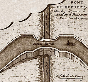
WThe Répudre Aqueduct is the first aqueduct built on the Canal du Midi. Pierre-Paul Riquet designed it to cross the Répudre River. It was built by Emmanuel d'Estan. It was designed in 1675 and completed in 1676, but was severely damaged that winter and had to be rebuilt. It is one of three original aqueducts created by Pierre-Paul Riquet during the building of the canal from 1667 to 1681.
 W
WThe rigole de la montagne was an important facet of the Canal du Midi, engineered by Pierre-Paul Riquet in southern France. The canal itself was built during 1666-1681. A critical aspect of the Canal du Midi was the supply of sufficient water to feed the canal. Each boat traversing its length would require a large quantity of water in the locks in order to climb or descend.
 W
WThe critical feature of the Canal du Midi was to provide sufficient water to ensure that the lock system continued to function, even through the summer months. The first part of this endeavor was the rigole de la plaine. It carried water from the Sor River, at Pontcrouzet, to the Bassin de Naurouze, where the water was to enter the canal. This was done in 1667.
 W
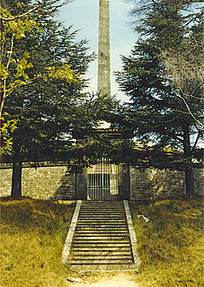
WThe Riquet Obelisk is dedicated to the creator of the Canal du Midi, Pierre-Paul Riquet. In 1827, the heirs of Riquet built the monument. The obelisk has a dedication: "To Pierre-Paul Riquet, Baron Bonrepos, author of the Two Seas Canal in Languedoc". It is erected near the site of the former octagonal holding tank, called the Bassin de Naurouze, created during the building of the Canal du Midi.
 W
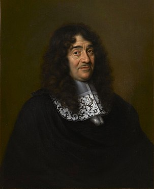
WPierre-Paul Riquet, Baron de Bonrepos was the engineer and canal-builder responsible for the construction of the Canal du Midi.
WThe Seuil de Naurouze, or Col de Naurouze, is the highest point of the Canal du Midi in southern France. It is the watershed point identified by Pierre-Paul Riquet when he designed and built the canal. Water falling on the western side of this point flows to the Atlantic Ocean and on the eastern side to the Mediterranean Sea. It is on the border of the department of Haute-Garonne and the department of the Aude.
WSiphon sluices are one of the many water management devices used on the Canal du Midi to regulate the level of the water. The siphon acts as an automatic water level regulator. The épanchoir à siphon, or siphon sluice, was designed by Bertrand Garripuy (Garipuy) Jr., the son of the chief engineer. The first épanchoir siphon was built in 1776 near Capestang and the second in 1778 at Ventenac.
WSiphon sluices are one of the many water management devices used on the Canal du Midi to regulate the level of the water. The siphon acts as an automatic water level regulator. The épanchoir à siphon, or siphon sluice, was designed by Bertrand Garripuy (Garipuy) Jr., the son of the chief engineer. The first épanchoir siphon was built in 1776 near Capestang and the second in 1778 at Ventenac.
 W
WÉtang de Thau or Bassin de Thau is the largest of a string of lagoons (étangs) that stretch along the French coast from the Rhône River to the foothills of the Pyrenees and the border to Spain in the Languedoc-Roussillon. Although it has a high salinity, it is considered the second largest lake in France.
WThe rigole de la montagne was an important facet of the Canal du Midi, engineered by Pierre-Paul Riquet in southern France. The canal itself was built during 1666-1681. A critical aspect of the Canal du Midi was the supply of sufficient water to feed the canal. Each boat traversing its length would require a large quantity of water in the locks in order to climb or descend.
WThe critical feature of the Canal du Midi was to provide sufficient water to ensure that the lock system continued to function, even through the summer months. The first part of this endeavor was the rigole de la plaine. It carried water from the Sor River, at Pontcrouzet, to the Bassin de Naurouze, where the water was to enter the canal. This was done in 1667.