 W
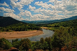
WThe Agrafiotis is a river in Evrytania, Greece. The river takes its name from Agrafa, the mountainous region where it flows. The river begins near the village Trovato in the north of Evrytania. It flows south through a valley with forests and small farmlands. It is crossed by a few stone bridges. Near the village Tripotamo, the river empties into Kremasta Reservoir, built in 1969, which is drained by the river Acheloos. The Kremasta Reservoir is the largest in Greece.
 W
WThe Angitis, also known as Angista; {Bulgarian: Драматица; Dramatitsa), is a tributary of the Strymonas in Northern Greece. The river is 75 km (47 mi) long and an important tributary of the Strymonas.
 W
WThe Arachthos is a river in eastern Epirus, Greece. Its source is in the Pindus mountains, near the town Metsovo. It is 110 km (68 mi) long, and its drainage area is 2,209 km2 (853 sq mi). Its upper course is known as Metsovitikos. From its confluence with the Dipotamos near the village of Batza it is called Arachthos. It flows towards the south, passing between the Athamanika and the Xerovouni mountains. In this place meets the Plaka Bridge, the largest one-arch stone bridge in Greece. It enters the large Pournari Reservoir, in the Arta regional unit, which is about 18 km² and prevents flooding of the city of Arta and also supplies water to most of Epirus. The town of Peta is situated near the dam. Arta, about 8 km downstream of the dam, is the largest town on the river. Arta's historic landmark is the stone Bridge of Arta over the Arachthos. The river continues through the lowlands south of Arta, and finally empties into the Ambracian Gulf near Kommeno, 16 km southeast of Arta.
 W
WThe Arda is a 290-kilometre-long (180 mi) river in Bulgaria and Greece. It is a tributary of the Maritsa. Its source lies in the Bulgarian Rhodope Mountains near the village Arda, part of the municipality of Smolyan. It flows eastward past Rudozem, Kardzhali and Ivaylovgrad and enters Greece in the northern part of the Evros regional unit. It flows into the Maritsa on the border of Greece and Turkey, between the Greek village Kastanies and the Turkish city Edirne. In the Bulgarian section there are three hydroelectric and irrigation dams, Kardzhali Dam, Studen Kladenets and Ivaylovgrad Dam. The Bulgarian section is 229 kilometres (142 mi) long, making the Arda the longest river in the Rhodopes. The medieval Dyavolski most arch bridge crosses the river 10 kilometres (6 mi) from Ardino.
 W
WCephissus is a river in the vicinity of Athens, Greece.
 W
WThe Cephissus, called the Boeotian Cephissus to distinguish it from other rivers of the same name, or Kifisos is a river in central Greece. In Greek mythology the river god Cephissus was associated with this river. The river rises at Lilaia in Phocis, on the northwestern slope of Mount Parnassus. It flows east through the Boeotian plain, passing the towns Amfikleia, Kato Tithorea and Orchomenos. It drained into Lake Copais, which was therefore also called the Cephisian Lake, until 1887, when the lake was drained. An artificial outflow has been created to Lake Yliki, further east.
 W
WThe Charadros is a river in the northern part of Achaea, Greece. Its course lies entirely within the municipality of Patras. It is 7.6 km (4.7 mi) long.
 W
WThe Dospat is a river in the Western Rhodope Mountains, the most important tributary of the Mesta.
 W
WThe Drino or Drinos is a river in southern Albania and northwestern Greece, tributary of the Vjosë. Its source is in the northwestern part of the Ioannina regional unit, near the village Delvinaki. It flows initially southwest, then northwest and crosses the Albanian border near Ktismata. It continues northwest through Gjirokastër and flows into the Vjosë near Tepelenë.
 W
WThe Enipeas or Enipeus is a river in central Greece, tributary of the Pineios near Farkadona. It is 84 km (52 mi) long. Its source is in the northern part of Phthiotis, on the plateau of Domokos. Its course runs through several of the tetrades of ancient Thessaly, from Achaea Phthiotis in South through Phthia to finally flow into the Pineios in Histiaeotis.
 W
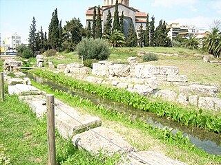
WEridanos was the small stream that flowed from a source in the foothills of the Lykabettos, through the Agora of ancient Athens in Greece to the archaeological site of the Kerameikos, where its bed is still visible. In this area lives a population of Greek tortoise.
 W
WErymanthos is a river in the western part of the Peloponnese in Greece. Its source is on the southern slope of the Mount Erymanthos, near the village Agrampela, Achaea. It flows towards the south through a rocky landscape and receives several small tributaries. The river flows into an area rich in pine trees and passes several small mountain villages including Tripotama. Beyond Tripotama it forms the border between Elis and Arcadia. It flows east of the Foloi oak forest. The river empties into the Alfeios 5 km west of the Ladon (river) confluence, near the village Tripotamia.
 W
WThe Erythropotamos or Luda reka is a river in southern Bulgaria and northeastern Greece. Its Turkish name was Kızıldelisu. Its source is near Mega Dereio. It flows into the Maritsa (Evros) near Didymoteicho.
 W
WGallikos is a river in Central Macedonia, Greece. It was known as Echedoros (Εχέδωρος) in antiquity and Gomaropnichtis (Γομαροπνίχτης) in Middle Ages. The current name probably comes from the ancient Roman colony Callicum near the river.
 W
WThe Geropotamos is a watercourse in southern Crete in Greece. Its drainage area is 553 km2 (214 sq mi). It rises on the north slope of the Asterousia Mountains, near the village Sternes. It flows west through the Messara Plain and discharges into the Libyan Sea near Tympaki. This river was a source of water supply for the ancient Minoan settlement of Phaistos. The Ieropotamos was heavily drawn upon by the Minoans because of the intensity of farming, even in the Bronze Age at Phaistos. Scientists have determined that the groundwater basin may have been overdrafted some time in the Bronze Age, being a contributing factor to the mysterious depopulation of Phaistos.
 W
WGranitsiotis is a river in northwestern Evrytania, Greece. It is a tributary of the Acheloos. It flows through the village Granitsa.
 W
WKladeos was a river god in Greek mythology, one of the sons of Oceanus and Tethys.
 W
WKrathis is a river in the eastern part of Achaea, southern Greece. The river flows through the municipal unit of Akrata. It is 32.6 km (20.3 mi) long.
 W
WThe Loudias or Lydias (Λυδίας), popularly called Mavroneri is a river in Central Macedonia that flows through the regional units of Pella and Thessaloniki.
 W
WThe Louros is a river in the Epirus region, in northwestern Greece. It is 80 km (50 mi) long, and its drainage area is 963 km2 (372 sq mi). It emerges from the ground in a large spring located immediately north of the village of Vouliasta, in Ioannina regional unit. It flows south through a canyon, and then a dam followed by a hydroelectric power station. The Louros flows past town of Filippiada, forming the boundary between Arta regional unit and Preveza regional unit. The river then veers east into the Preveza regional unit, flowing through the municipality of Louros, named after the river. The Louros then empties into the marshes at the northern end of the Ambracian Gulf.
 W
WThe Lousios, also known in antiquity as Gortynius or Gortynios, is a river and a gorge in western Arcadia that stretches from Karytaina north to Dimitsana in Greece. The river begins near Lykochori and flows through the Lousios Gorge. The river is treacherous and flows rapidly. It empties into the Alfeios 2.5 kilometres (1.6 mi) northwest of Karytaina and south of Atsicholos.
 W
WThe Megdovas, also known as Tavropos, is a river that flows through the Karditsa and Evrytania regional units, Greece. It is 78 km (48 mi) long.
 W
WMeilichos is a torrent in the northwestern part of Achaea, southern Greece. The river flows from a spring near Skioessa near the northern part of the Panachaiko mountain west of the ravine of Charadros to the Gulf of Patras. It passes north of Skioessa, under a viaduct of Motorway 5, through the village Sychaina, now a neighbourhood of Patras, it empties west of the neighbourhood of Agyia.
 W
WThe Mornos is a river in Phocis and Aetolia-Acarnania in Greece. It is 70 km (43 mi) long. Its source is in the southwestern part of the Oiti mountains, near the village Mavrolithari, Phocis. It flows towards the south, and enters the Mornos Reservoir near the village Lefkaditi. The dam was completed in 1979. It leaves the reservoir towards the west, near Perivoli. The river continues through a deep, sparsely populated valley, and turns south near Trikorfo. The lower course of the Mornos forms the boundary between Phocis and Aetolia-Acarnania. The Mornos empties into the Gulf of Corinth about 3 km southeast of Nafpaktos.
 W
WThe Neda is a river in the western Peloponnese in Greece. It is 31 km (19 mi) long, and its drainage area is 278 km2 (107 sq mi). It is unique in the sense that it is the only river in Greece with a feminine name.
 W
WThe Pamisos is the largest river of the Messenia regional unit of the southern Peloponnese in Greece. It is 44 km (27 mi) long, and its drainage area is 568 km2 (219 sq mi). Its source is on the western slopes of the Taygetus mountains, near the village Agios Floros. It runs through the municipal units of Arfara, Ithomi, Androusa, Aris, Messini, Thouria and Kalamata. It flows into the Messenian Gulf east of Messini and west of Kalamata.
 W
WPanagitsa is a small stream in the south of the Patras area in northcentral Achaea, Greece. The source of the Panagitsa is on the western slope of the mountain Omplos, near Omplos Monastery. It flows northwest along the villages Krini and Ovrya. It flows into the Gulf of Patras in Paralia.
 W
WParapeiros is a river in the western part of Achaea, Greece. It is 28.5 km (17.7 mi) long. The Parapeiros begins in the western part of the Erymanthos mountains close to Alepochori. It passes through the municipal units of Tritaia and Farres. It empties into the river Peiros near the village Agios Stefanos.
 W
WThe Pavllë is a river in northwestern Greece and southern Albania. Its source is in the Mourgana mountains in Greece, near the village Ampelonas, Thesprotia. It flows west into Albania, along the villages Vagalat and Shkallë. It flows into the Ionian Sea a few kilometres southwest of the archaeological site Butrint. There is a bridge across the river near the village Ampelonas, built in 1798.
 W
WThe Peiros is a river in the central and the northwestern parts of Achaea, Greece. It is 42.6 km (26.5 mi) long.
 W
WThe Pineiós is a river in Peloponnese, Greece. It is probably not named after the god Peneus. It is 70 km (43 mi) long. Its source is on the southwestern slope of the mountain Erymanthus, near the village Kryovrysi. It empties into a bay of the Ionian Sea, southwest of Gastouni. For a part of its upper course, it forms the border between Elis and Achaea. The river flows through the plain of Elis. The river passes through the following villages:Kryovrysi Agia Triada Kalfas Kentro Kalyvia Ilidos Agia Mavra Kavasila Vartholomio
 W
WThe Pineios is a river in Thessaly, Greece. The river is named after the god Peneus. During the later Middle Ages, it was also known as the Salamvrias or Salavrias (Σαλα[μ]βριάς).
 W
WThe Pleistos is a river in central Greece. It rises at Mount Parnassos near the town Arachova, Boeotia. It flows west through a deep valley, between the mountains Parnassos and Kirphe, passing south of Delphi, through the Delphic Landscape and the plain of Amphissa and flows into the Corinthian Gulf near Kirra. The water of the Castalian Spring flow into Pleistos.
 W
WThe Sarantaporos is a river in northwestern Greece and southern Albania. It is a right tributary of the river Aoös (Vjosë), which flows into the Adriatic Sea. Its length is 50 km (31 mi), of which the final approx. 10 km (6.2 mi) form the border between Greece and Albania. Its source is between the mountain ranges Gramos and Voio, in the Kastoria regional unit. It flows through the municipal units Arrenes, Mastorochoria and Konitsa in Greece, and the municipalities Qendër Leskovik and Çarshovë in Albania. Its basin area is 870 km2 (340 sq mi), and its year-average discharge is 6.93 m3 (245 cu ft) per second.
 W
WThe Spercheios, also known as the Spercheus from its Latin name, is a river in Phthiotis in central Greece. It is 80 km (50 mi) long, and its drainage area is 1,830 km2 (710 sq mi). It was worshipped as a god in the ancient Greek religion and appears in some collections of Greek mythology. In antiquity, its upper valley was known as Ainis. In AD 997, its valley was the site of the Battle of Spercheios, which ended Bulgarian incursions into the Byzantine Empire.
 W
WThe Tanos or Tanus (Τάνος), also called the Tanaus or Tanaos (Τάναος) is a river of the Peloponnese, Greece. In antiquity it was the northern border of the Thyreatis, or territory of the city of Thyrea, in the ancient region of Cynuria. It waters one of the most fertile plains in the Peloponnesus. The river rises in the summits of Mount Parnon, and falls into the sea, at present north of Astros, but earlier south of the latter place. It formed the boundary between the Argeia and ancient Laconia in the time of Euripides, who accordingly represents it as the boundary between the two states in the heroic age.
 W
WThe Vouraikos is a river in Achaea, Greece. In ancient times it was called Erasinos. Its source is in the Aroania mountains, near the village of Priolithos. It flows past the towns of Kalavryta and Diakopto, and flows into the Gulf of Corinth near Diakopto. It is 37.5 km (23.3 mi) long. The name is derived from Boura, a mythological daughter of Ion and Helice who was beloved by Hercules, who according to legend opened the gorge in order to get close to her. This is the Vouraikos gorge, which has a length of about 20 km. In the gorge the river passes along dense vegetation and steep cliffs, waterfalls and caves. The Diakofto–Kalavryta Railway passes through the Vouraikos gorge.