 W
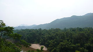
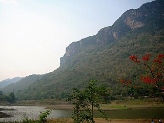
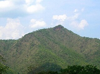
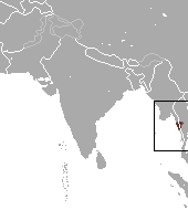
WTenasserim Hills or Tenasserim Range is the geographical name of a roughly 1,700 km long mountain chain, part of the Indo-Malayan mountain system in Southeast Asia.
 W
WBan Kao is a village and tambon (sub-district) of Mueang Kanchanaburi District, in Kanchanaburi Province, Thailand. In 2005 it had a population of 12,657 people. The tambon contains 15 villages.
 W
WBaulu Taung is a mountain of the Tenasserim Hills, Burma.
 W
WBilauktaung is a subrange of the Tenasserim Hills. It is located in Burma on the border with Thailand. It extends from the Dawna Range for about 400 km along the frontier area to the Kra Isthmus.
 W
WBong Ti is a village and tambon (subdistrict) of Sai Yok District, in Kanchanaburi Province, Thailand. The tambon contains four villages.
 W
WBotia udomritthiruji is a small freshwater fish in the loach family Botiidae native to the Great Tenasserim (Tanintharyi) River Basin in south Burma. It reaches 13–15 cm (5.1–5.9 in) in length, and the female's abdomen plumper than the abdomen of the male.
 W
WKaeng Krachan National Park is the largest national park of Thailand. It is on the border with Burma, contiguous with the Tanintharyi Nature Reserve. It is a popular park owing to its proximity to the tourist town of Hua Hin.
 W
WKaeng Krung National Park is a national park in southern Thailand, protecting 541 km2 of forests in the Phuket mountain range. It was declared a national park on 4 December 1991.
WKhao Luang (เขาหลวง) is the tallest mountain in southern Thailand. It is in Nakhon Si Thammarat Province.
 W
WKhao Nom Nang, "female breast mountain", is a 752 metres (2,467 ft) high mountain in the Tenasserim Hills in Kanchanaburi Province, Thailand.
WKhao Nom Sao (เขานมสาว), "female breast mountain", is a land feature located in Ranong Province, Thailand.
 W
WKhao Sam Roi Yot is a marine national park in Kui Buri District, Prachuap Khiri Khan Province, Thailand. It covers 98.08 km2, of which 20.88 km2 are marine areas. The park was established in 1966, and was the first coastal national park of Thailand. The park includes Thailand's largest freshwater marsh.
 W
WKhao Sok National Park is in Surat Thani Province, Thailand. Its area is 739 km2 (285 sq mi), and it includes the 165 km2 (64 sq mi) Cheow Lan Lake contained by the Ratchaprapha Dam. The park is the largest area of virgin forest in southern Thailand and is a remnant of rain forest which is older and more diverse than the Amazon rain forest.
WKhlong Nakha is a wildlife sanctuary in southern Thailand, located in the southeast of Ranong Province. It is located within the hills of the Phuket mountain range.
 W
WKhlong Phanom is a national park in southern Thailand, protecting 410.4 km² of forests within the Phuket mountain range. It was declared a national park on November 17, 2000.
WKhlong Phraya is a wildlife sanctuary in southern Thailand, at the boundary of Surat Thani and Krabi Provinces.
WKhlong Saeng is a wildlife sanctuary in southern Thailand, in western Surat Thani Province. The wildlife sanctuary is named after the river (khlong) Saeng, a tributary of the Phum Duang River.
WKhlong Yan is a wildlife sanctuary in southern Thailand, located in the west of Surat Thani Province. It is located between the Khao Sok and Kaeng Krung National Park within the hills of the Phuket mountain range.
 W
WLenya National Park is a proposed national park in Myanmar. It has been proposed since 2002 to be established in the Tenasserim Hills over an area of 1,761 km2 (680 sq mi) and extended by 1,399 km2 (540 sq mi) in 2004. The area comprises evergreen forest at elevations from 15 to 1,240 m, which is governed by Myanmar's Forest Department. By 2011, the national park was not yet gazetted and its boundaries still not demarcated.
 W
WThe Tenasserim lutung is a species of lutung. It is found in Myanmar and Thailand.
WMyinmoletkat Taung is the highest mountain of the Bilauktaung, Tenasserim Hills, Burma.
 W
WThe Nakhon Si Thammarat Range is a mountain range on the Malay peninsula in southern Thailand, running in a north-south direction. This mountain chain is also sometimes named Banthat Range (ทิวเขาบรรทัด), a name which is however also used to refer to the Chanthaburi mountain range.
WPhu Nam Ron is a pass across the Tenasserim Hills on the border between Thailand and Myanmar, at an elevation of 350 metres (1,150 ft). The border checkpoint on the Thai side is in Ban Kao Subdistrict, Mueang Kanchanaburi District, Kanchanaburi Province.
 W
WThe Phuket Range is a subrange of the Tenasserim Hills in the Kra Isthmus, Thailand.
 W
WPinus latteri, or Tenasserim pine, is a pine native to Mainland Southeast Asia. It grows in the mountains of southeastern Burma, northern Thailand, Laos, Cambodia, Vietnam, and on the Chinese island of Hainan.
 W
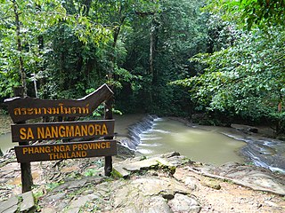
WSa Nang Manora is a forest park in southern Thailand. It covers an area of 0.29 km2 of the Khao Thoi-Nang Hong Forest, Nop Pring Sub-district, Mueang District, Phang Nga Province, about four km north of Phang Nga town. It was established on 15 September 1980.
 W
WSai Yok National Park is a national park in Sai Yok district, Kanchanaburi Province, Thailand. The park, home to mountains, waterfalls and caves, is part of the Western Forest Complex protected area.
WSi Phang Nga National Park is in Phang Nga Province in southern Thailand, covering the eastern parts of the districts Khura Buri and Takua Pa.
 W
WSingkhon Pass, also referred to as Sing Khon and as Maw Daung after the name of the Burmese town west of the border, is a pass across the Tenasserim Hills on the border between Thailand and Myanmar, at an elevation of 245 metres (804 ft). The pass is close to the narrowest point of Thailand in Khlong Wan (คลองวาฬ) subdistrict, Mueang Prachuap Khiri Khan District, Prachuap Khiri Khan Province.
 W
WTai Romyen National Park is in the east of Surat Thani Province in southern Thailand. The park consists of the northern end of the Nakhon Si Thammarat mountain range and is mostly covered with forests. It was established on 31 December 1991 and covers an area of 425 km2 in the districts Kanchanadit, Ban Na San, and Wiang Sa.
WTanintharyi National Park is a proposed national park in Myanmar's Tanintharyi Region that was supposed to cover an area of 2,072 km2 (800 sq mi) of mangrove and evergreen forests at an elevation from sea level to 1,490 m (4,890 ft). It was proposed in 2002. Wildlife species in this area include Asian elephant, sambar deer, Malayan tapir, Indian muntjac, and leopard.
 W
WTanintharyi Nature Reserve is a strict nature reserve in Myanmar's Tenasserim Hills, covering 1,699.99 km2 (656.37 sq mi). In elevation, it ranges from at an elevation of 20–130 m (66–427 ft). Most of the tropical rain forest is evergreen, interspersed with some grassland. The reserve provides habitat to Asian elephant and Gurney's pitta. It was gazetted in 2005 for the maintenance of natural resources, scientific research and education of local people in surrounding communities.
 W
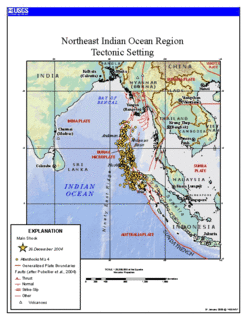
WThe Three Pagodas Fault is a right-lateral displacement strike-slip fault between Burma and Thailand named after the Three Pagodas Pass. It developed as a consequence of the collision between the Indian and the Eurasian Plate. The Three Pagodas Fault Zone (TPFZ) is a roughly 50 km wide zone separating the westernmost range of the Tenasserim Hills from the Tenasserim coast in Myanmar. The whole area is marked by a great number of fault traces and homoclinal ridges of Paleozoic limestone.
 W
WThree Pagodas Pass is a pass in the Tenasserim Hills on the border between Thailand and Myanmar (Burma), at an elevation of 282 metres (925 ft). The pass links the town of Sangkhla Buri in the north of Kanchanaburi Province, Thailand, to the town of Payathonsu in the south of Kayin State, Myanmar.
WThe Ton Pariwat Wildlife Sanctuary is located in the north of Mueang Phang Nga district, Phang Nga Province, southern Thailand. It covers an area of 224 square kilometres of forested hills at the southern end of the Phuket mountain range. It is part of a system of protected areas known as the southern forest complex, continued to the northwest by the Khlong Phanom National Park.
WWang Krachae is a village and tambon (subdistrict) of Sai Yok District, in Kanchanaburi Province, Thailand. In 2005 it had a population of 7,283 people. The tambon contains nine villages.
WYage Taung is a mountain of the Tenasserim Hills, Burma. This mountain rises within the Tanintharyi National Park which is coterminous with the Kaeng Krachan National Park zone over the border with Thailand.