 W
WThe Apón River is a river of Venezuela. It drains into Lake Maracaibo.
 W
WAragua River flows into the endorheic Lake Valencia in Aragua State, Venezuela.
 W
WThe Aroa River is a river in northwestern Venezuela. It runs parallel and west of the Yaracuy River. The Aroa River empties into the Caribbean Sea.
 W
WAtabapo River is a river of Venezuela and Colombia. It forms the international boundary between the two countries for much of its length. It is part of the Orinoco River basin.
 W
WThe Barima River is a tributary of the Orinoco River, entering 6 kilometres (4 mi) from the Atlantic Ocean. It originates from the Imataka Mountains in Guyana, flowing for approximately 340 kilometres (210 mi) before entering Venezuela about 80 kilometres (50 mi) from its mouth. Near the Duquari Creek, the Arawatta Rock, a distinct large granite rock, is located.
 W
WThe Caño Manamo is a distributary of the Orinoco River. It branches northwards from the main channel of the Orinoco to delimit the western edge of the Orinoco Delta, ultimately emptying into the Gulf of Paria. Tucupita, the capital of Delta Amacuro state, is located on the east bank (right) of the Caño Manamo. Manamo is a Warao word meaning "two."
 W
WCapanaparo River is a river of Colombia and Venezuela. It is part of the Orinoco River basin. In Venezuela together with the Cinaruco River, other smaller rivers and the area around them they form the Santos Luzardo National Park since 1988.
 W
WCaparo River is a river of Venezuela. It is part of the Orinoco River basin and a tributary of the Sioca River, itself a tributary of the Apure River.
 W
WThe Catatumbo River is a river rising in northern Colombia, flowing into Lake Maracaibo in Venezuela. The Catatumbo River is approximately 340 kilometres (210 mi) long. It forms a part of the international boundary between the two countries.
 W
WCinaruco River is a river of Colombia and Venezuela. It is part of the Orinoco River basin. It has partially clear tanic waters. In Venezuela this river is part of the Santos Luzardo National Park since the year 1988. The Cinaruco River together with the Capanaparo River, other smaller rivers and the area around them form this national park. It houses a big biodiversity and many fisherman go each year looking for peacock bass. Three different species of peacock bass are found in this river: Cichla intermedia, Cichla orinocensis and Cichla temensis from smallest to biggest.
 W
WThe Cojedes River is a tributary of the Orinoco River in central Venezuela. The Cojedes originates in Lara state, and flows southeast through a gap between the Cordillera de Mérida and the Cordillera de la Costa and across the Llanos grasslands of the Orinoco Basin to empty into the Apure River, which flows east to join the Orinoco. The river drains portions of the states of Lara, Yaracuy, Portuguesa, Cojedes, Barinas, and Guárico.
WCunucunuma River is a river of Venezuela. It is part of the Orinoco River basin.
 W
WCuquenán River is a river of Venezuela. It is part of the Orinoco River basin.
 W
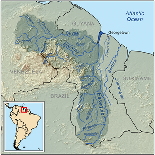
WThe Cuyuni River is a South American river and a tributary of the Essequibo River. It rises in the Guiana Highlands of Venezuela where it descends northward to El Dorado, and turns eastward to meander through the tropical rain forests of Guyana. It finally turns southeastward, flowing to its confluence with the Mazaruni River. The Cuyuni River marks the limit of the disputed territory of Guyana Essequibo for approximately 100 kilometres (62 mi).
WThe Escalante River is a river of Venezuela. It drains into Lake Maracaibo.
 W
WGuarapiche River is a river of north-eastern Venezuela. It flows into the San Juan River.
 W
WGuárico River is a river in Venezuela.
WHueque River is a river of northern Venezuela. It flows into the Caribbean Sea.
 W
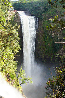
WKamarang River is a river of the Essequibo River basin. The river originates in Venezuela where it is called Río Camarán or Río Camurán. Its source is located right next to the Troncal 10, in the middle of the Gran Sabana region. The nascent river first flows in parallel to the road in a southeasterly direction. It then passes the road a few meters after the Campamento Kamoiran. Here the river forms the Kamoiran rapids. Its course then turns more eastward for several kilometers through open Savannah. Shortly after entering the disputed Guayana Esequiba territory in Guyana the river drops roughly 160 meters at the impressive Kamarang falls creating a 40 meter wide water curtain.
 W
WThe Manzanares is an 80 km long river in Venezuela. It flows into the Caribbean Sea.
 W
WThe Meta River is a major left tributary of the Orinoco River in eastern Colombia and southern Venezuela, South America. The Meta originates in the Eastern Ranges of the Andes and flows through the Meta Department, Colombia as the confluence of the Humea, Guatiquía and Guayuriba rivers. It flows east-northeastward across the Llanos Orientales of Colombia following the direction of the Meta Fault. The Meta forms the northern boundary of Vichada Department, first with Casanare Department, then with Arauca Department, and finally with Venezuela, down to Puerto Carreño where it flows into the Orinoco.
WThe Motatán River is a river of Venezuela. It drains into Lake Maracaibo.
 W
WNeverí River is a river of northern Venezuela. It flows into the Caribbean Sea.
WThe Palmar River is a river of Venezuela. It drains into Lake Maracaibo.
WThe Paragua River is a river of Venezuela. It is part of the Orinoco River basin. It is the largest tributary of the Caroní River.
 W
WQuebrada la Boyera is a small river in the Mirandino sector of the city of Caracas in Venezuela. Its waters flow through the Municipalities of El Hatillo and Baruta of the state Miranda. It originates on the eastern slope of Cerro El Volcán in El Hatillo Municipality, at 1350 metres. It flows into the Quebrada La Guairita in the La Trinidad urbanization, in front of the north face of the Procter & Gamble building behind the building of the KFC La Trinidad at 975 metres.
 W
WQuebrada La Guairita is a small river that collects the waters of the streams from the areas of Baruta, La Trinidad, El Hatillo and El Cafetal in Venezuela, originating in the place known as Ojo de Agua in southern Baruta at an approximate height of 1,150 metres (3,770 ft).
 W
WQuebrada Sorocaima is a small river in the Mirandino sector of the city of Caracas, in Venezuela. Its waters flow through the municipality of Baruta in the state of Miranda.
 W
WThe Quinimarí River is a river in northwestern Venezuela.
 W
WThe river Cabriales is an important river of Venezuela, which crosses the city of Valencia and much of the state of Carabobo.
 W
WThe Tocuyo River is a river of Venezuela. It drains into the Caribbean Sea.
 W
WThe Unare River is a river of Venezuela. It drains into the Caribbean Sea. In the 17th century the Dutch had a fort at the mouth of the river. It was constructed to protect their salt collection in the area. The other Dutch fort ever to stand on what is now Venezuelan soil stood on the little uninhabited islet La Tortuga, just west of Isla Margarita. It was built for the same reason as the one in Unare: to protect the salt harvesting activities of the Dutch. The Caribbean islands St. Maarten and Bonaire would subsequently satisfy the Dutch demand for salt.
WThe Uribante River is a river of Venezuela, a tributary of the Apure River.
 W
WThe Ventuari River is the largest tributary of the Orinoco in southern Venezuela. The Ventuari flows from south-central Venezuela in the Guiana Highlands southwest into the Orinoco River. It is 520 km (320 mi) long and its major tributary is the Manapiare River.
 W
WThe Yaracuy River is a river of Venezuela. It drains into the Caribbean Sea.
 W
WYuruarí River is a river of Venezuela. It is part of the Essequibo River basin.
 W
WZulia River is a river in Venezuela and Colombia. It is a tributary of the Catatumbo River. The Zulia forms a small part of the international boundary between the two countries.