 W
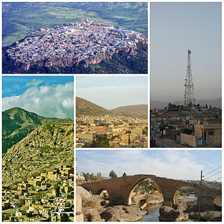
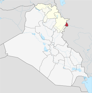
WAkre District is a district in Duhok Governorate, Kurdistan Region. The administrative center is the city of Akre.
 W
WAmadiya District is a district of Dohuk Governorate in Kurdistan Region, Iraq. The administrative centre is Amadiya.
 W
WThe Badush Dam is an unfinished multi-purpose dam on the Tigris River, located near Badush, 16 kilometres (9.9 mi) northwest of Mosul in the Ninawa Governorate, northern Iraq.
 W
WBahdinan or Badinan (1376–1843) was one of the most powerful and enduring Kurdish principalities. It was founded by Baha-al-Din originally from Şemzînan area in Hakkari in sometime between 13th or 14th century CE. The capital of this emirate was Amadiya for a long time. The rulers of the Bahdinan emirate claimed descent from the Abbasid Caliphate, an early dynasty in Islamic history.
WThe Bekhme Dam is an unfinished multi-purpose rock-fill dam on the Great Zab 60 kilometres (37 mi) northeast of Erbil, in the Erbil Governorate of Kurdistan Region, Iraq.
 W
WByara District is a district of the Halabja Governorate, Iraq. Its hub is the city of Byara.
 W
WChamchamal District is a district of the Sulaymaniyah Governorate in the Kurdistan Region of Iraq.
 W
WThis is a list of the cities in Kurdistan Region in Iraq.
 W
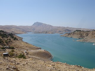
WThe Darbandikhan Dam is a multi-purpose embankment dam on the Diyala River in northern Sulaymaniyah Governorate, Iraq. It was constructed between 1956 and 1961. The purpose of the dam is irrigation, flood control, hydroelectric power production and recreation. Due to poor construction and neglect, the dam and its 249 MW power station have undergone several repairs over the years. A rehabilitation of the power station began in 2007 and was completed in 2013.
WDarbandokeh District is a district of the Sulaymaniyah Governorate, Iraq. Its main town is Darbandikhan.
 W
WThe Dohuk Dam is an earth-fill embankment dam on the Dohuk River just north of Dohuk in Dahuk Governorate, Iraq. The dam was completed in 1988 with the primary purpose of providing water for irrigation. It is 60 m (197 ft) tall and can withhold 52,000,000 m3 (42,157 acre⋅ft) of water. The dam has a bell-mouth spillway with a maximum discharge of 81 m3/s (2,860 cu ft/s).
 W
WDuhok Governorate is a governorate in the autonomous Kurdistan Region of Iraq. Its capital is the city of Duhok. It includes Zakho, near the Ibrahim Khalil border crossing with Şırnak Province, Turkey. It borders the Al-Hasakah Governorate of Syria. Before 1976, it was part of Nineveh Governorate, which was called Mosul Governorate. Duhok Governorate is inhabited by Kurds and Assyrians. The estimated population in 2018 was 1,292,535.
WDokan District is a district of the Sulaymaniyah Governorate, Kurdistan Region, Iraq. Its main town is Dokan.
 W
WErbil Governorate, sometimes referred to by the alternative spelling Arbil Governorate, is a governorate of Iraq in Iraqi Kurdistan. It is the capital and economic hub of the autonomous region of Kurdistan Region.
 W
WThe Euphrates is the longest and one of the most historically important rivers of Western Asia. Together with the Tigris, it is one of the two defining rivers of Mesopotamia. Originating in the Armenian Highlands of eastern Turkey, the Euphrates flows through Syria and Iraq to join the Tigris in the Shatt al-Arab, which empties into the Persian Gulf.
 W
WGeli Ali Beg Waterfall is located in the Kurdistan Region of Iraq, which lies some 130 km north of Arbil.
 W
WThe Great Zab or Upper Zab is an approximately 400-kilometre (250 mi) long river flowing through Turkey and Iraq. It rises in Turkey near Lake Van and joins the Tigris in Iraq south of Mosul. The drainage basin of the Great Zab covers approximately 40,300 square kilometres (15,600 sq mi), and during its course, the rivers collects the water from many tributaries. The river and its tributaries are primarily fed by rainfall and snowmelt – as a result of which discharge fluctuates highly throughout the year. At least six dams have been planned on the Great Zab and its tributaries, but construction of only one, the Bekhme Dam, has commenced but was halted after the Gulf War.
 W
WHalabja Governorate is a governorate in the autonomous region of Kurdistan Region in Iraq. The governorate was established in 2014, splitting off from Sulaymaniyah Governorate and becoming the fourth governorate in the Kurdistan Region of Iraq Its capital is the city of Halabja.
 W
WIbrahim Khalil is a border crossing point between Turkey and Iraq. It is also called the Habur Border or Frontier Gate in English. Before the control point and gate there is a bridge crossing the Khabur river, which forms the natural border between Iraq and Turkey. The crossing is located to the south of the town of Silopi.
WKalar District is a district of the Sulaymaniyah Governorate, Iraqi Kurdistan.
 W
WThe Khabur or Little Khabur is river that rises in Turkey and flows through Iraq to join the Tigris at the tripoint of Turkey, Iraq and Syria.
 W
WThe Khazir River is a river of northern Iraq, a tributary of the Great Zab river, joining its right bank.
 W
WKifri District is one of the six districts of Diyala Governorate in Iraq. Its main town is Kifri. The population was estimated at 42,010 in 2003.
WThe Kifri District is one of the fifteen districts of Sulaymaniyah Governorate in Iraq. Its main town is Kifri. Most of the district is disputed, and overlaps with the adjacent Kifri District in the Diyala Governorate and Tooz District in the Saladin Governorate. However a small part of the district is recognised as part of the Sulaymaniyah Governorate in Kurdistan Region.
 W
WThe Little Zab or Lower Zab is a river that originates in Iran and joins the Tigris just south of Al Zab in the Kurdistan region of Iraq. It is approximately 400 kilometres (250 mi) long and drains an area of about 22,000 square kilometres (8,500 sq mi). The river is fed by rainfall and snowmelt, resulting in a peak discharge in spring and low water in summer and early fall. Two dams have been built on the Little Zab, regulating the river flow, providing water for irrigation and generating hydroelectricity. The Zagros Mountains have been occupied since at least the Lower Palaeolithic, but the earliest archaeological site in the Little Zab basin, Barda Balka, dates to the Middle Palaeolithic. Human occupation of the Little Zab basin has been attested for every period since then.
WThe Mawat District is one of the fifteen districts of Sulaymaniyah Governorate in Iraq. Its main town is Mawat.
 W
WPendro or Pendru is a village in Iraq's Kurdistan Region. In the Erbil Governorate, close to the border with Turkey, it is approximately 15–18 km to the north of Barzan. It has a population of over 2540 people and is in the territory of the Muzuri Kurds, one of the seven tribes of Barzani Kurds. It lies in a valley surrounded by low peaks. Mount Butin is about 4 km northeast of Pendro and the Sardav Canyon is north of the village. The villages of Banan and Shive are to the north, Hakkâri Province is to the northeast, Edlbey and Zet are to the east, Selke, Stope and Guiza Walati to the south, Binavye and Navkorka to the west, and Dezo and Spindare to the northwest. The area of Pendro covers over 10 km2 (4 sq mi). The terrain is highly mountainous, lying within the Zagros; less than 10% of the Pendro is below 1,225 m (4,019 ft), and its highest point is 2,534 m (8,314 ft). The mostly Kurdish population speaks local Bahdini dialects of Kurdish as their native language, and Central Kurdish in its standard form is the Kurdistan Region's official language.
WPshdar District is a district of the Sulaymaniyah Governorate in the Kurdistan Regional Government Region in Iraq. It is located east of the city of Sulaymaniyah, near the Iranian border. The most populous urban centre in the district is Qaladiza, with 220,836 inhabitants.
 W
WQaladiza or Qaladize is a town in Kurdistan Region, Iraq, north of Sulaymaniyah, near the Iranian border. It is surrounded by mountains like many parts of Kurdistan. The town is located in a middle of Pshdar. Qalladze means "Castle of Two Rivers" from the Kurdish words Qala= castle, dw= two and ze= river. In the south west of the City there is a Castle between two rivers.
 W
WThe Qandil Mountains, are a mountainous area of Iraqi Kurdistan near the Iraq-Iran border. The region belongs to the Zagros mountain range and is difficult to access, with extremely rugged terrain. The highest peaks reach over 3,000m.
WThe Qaradagh District is one of the fifteen districts of Sulaymaniyah Governorate in Iraq. Its main town is Qaradagh.
WRanya District is located in Sulaymaniyah Governorate, Iraqi Kurdistan, Iraq. Its capital is Ranya. The district has a population of 200,826. The district includes three towns, Çiwarqurne, Bêtwate and Hacî awa, and is the centre of the Bîtwên and Raperîn area. The region of Ranya has been inhabited since ancient times and is rich in archaeologic sites such as Tell Shemshara, Tell Bazmusian, Girdedême, Kameryan and Boskin hills and Ranya castle. Its history as a district dates from the Ottoman Empire period in (1789) when the first district commissioner was appointed. The main tribes in Ranya are the Jaff, Bilbas, Ako and Shawri. Agriculturally, the area is well known for its fertile soil. The principle crops are sunflowers, tobacco, rice, wheat and barley.
 W
WSapna Valley is a large valley in Kurdistan Region of Iraq, contained by two small mountain ranges to the north which are part of the greater Zagros mountain range. The valley is watered by the Great Zab river which flows along the eastern portion of the valley, and features hilly terrain in the central portion of it around Amadiya District.
 W
WShahrizor is a plain between Suleimania and Darbandikhan, situated in the southeastern part of Kurdistan Region, Iraq.
WSulaymaniya District is a district of the Sulaymaniyah Governorate, Iraq. Its main city is Sulaymaniyah, the capital of the Governorate.
 W
WSulaymaniyah Governorate or Sulaymaniyah Province is a mountainous governorate in the Kurdistan Region of Iraq. Its largest city is Sulaymaniyah. Halabja Governorate was formerly the Halabja District of Sulaymaniyah, until it became a separate governorate in 2014.
 W
WThe Tigris is the eastern of the two great rivers that define Mesopotamia, the other being the Euphrates. The river flows south from the mountains of the Armenian Highlands through the Syrian and Arabian Deserts, and empties into the Persian Gulf.
 W
WThe Zagros Mountains are a long mountain range in Iran, northern Iraq and southeastern Turkey. This mountain range has a total length of 1,600 km (990 mi). The Zagros mountain range begins in northwestern Iran and roughly follows Iran's western border, while covering much of southeastern Turkey and northeastern Iraq. From this border region, the range roughly follows Iran's coast on the Persian Gulf. It spans the whole length of the western and southwestern Iranian plateau, ending at the Strait of Hormuz. The highest point is Mount Dena, at 4,409 metres (14,465 ft).