 W
WBig Bay, also known as Awarua Bay, is a deep indentation in the southwestern coast of New Zealand's South Island, 40 kilometres north of Milford Sound and immediately to the north of Martins Bay. The bay is eight kilometres in width, and extends eight kilometres into the South Island, making an almost square indentation in the island's coastline. Its northern end is Awarua Point. Immediately beyond Long Reef, the rocky point at the southern end, is the mouth of the Hollyford River and Martins Bay. Big Bay has a sandy beach named Three Mile Beach. The Awarua River enters the bay at the northern end of the beach.
WBirchwood is a locality in the Southland region of New Zealand's South Island. It is situated west of Ohai and Nightcaps, and north of Tuatapere and Orawia, with the nearest state highway in Ohai.
WBrowns is a locality in Central Southland in New Zealand's South Island. It is just to the east of the town of Winton in the southwestern reaches of the Hokonui Hills. State Highway 96 passes through the town on its route between Winton and Springhills.
WDrummond is a small town in Southland, New Zealand. It is 35 kilometres (22 mi) north of Invercargill and 18 kilometres (11 mi) west of Winton.
WFortification is a locality in the western part of the Catlins region of Southland in New Zealand's South Island. Nearby settlements include Quarry Hills and Waikawa to the southeast, Tokanui to the southwest, and Waimahaka to the west. It is over 50 km east of Southland's main centre, Invercargill.
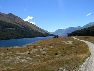
WGarston is a small settlement in northern Southland, in the South Island of New Zealand, located close to the region's boundary with Otago. It is the most inland settlement in New Zealand. It is situated south of Lake Wakatipu and close to the upper reaches of the Mataura River, between Kingston and Lumsden. Garston is connected to both Kingston and Lumsden by SH 6.
WGlencoe is a locality in the central Southland region of New Zealand's South Island. Named after Glen Coe in Scotland, it is situated in the Hokonui Hills on the route of State Highway 96 as it travels between Hedgehope and Waitane. The nearest town of significant size is Mataura to the east, while the city of Invercargill is to the southwest.
 W
WThe Great South Basin is an area of mainly sea to the south of the South Island of New Zealand.
WGrove Bush is a village in the Southland region of New Zealand's South Island. It is located on the banks of the Makarewa River on the Southland Plains near the foothills of the Hokonui Hills.
 W
WHalfmoon Bay lies on the eastern coast of Stewart Island/Rakiura in New Zealand.
WHokonui is a town in the Southland region of the South Island of New Zealand. The 2013 census recorded the town's population as 3,087.
WKapuka South is a locality in the Southland region of New Zealand's South Island. It is situated on Toetoes Bay and Waituna Lagoon. Kapuka and Ashers are to the north on the Southern Scenic Route.
WKennington is a town located in the Southland region of New Zealand’s South Island. It is situated on the Waihopai River on the eastern outskirts of the city of Invercargill. Other nearby settlements include Longbush, Myross Bush, Rimu, and Woodlands.
 W
WThe Kepler Mire, or Dismal Swamp east of Lake Manapouri, is the largest wetland in the Te Anau basin complex in New Zealand, covering more than 900 ha. Like the neighbouring mountain range, it is named in honour of astronomer Johannes Kepler.
 W
WLake Henry is a spring-fed lake of approximately 230m in diameter located in Te Anau, New Zealand. It is located south-east of the main township in Ivon Wilson Park.
 W
WLake Quill is a tarn located in New Zealand's Fiordland National Park at 979 metres (3,212 ft) above sea level. It is the source of Sutherland Falls, one of the highest waterfalls in the country and seventh-highest in the world, cascading from Lake Quill in three tiers into Milford Sound / Piopiotahi.
WLongbush is a community in the Southland region of New Zealand's South Island. It is located in a rural area outside the city of Invercargill on the banks of the Waihopai River. Just to the northeast is the larger town of Woodlands.There are two possible origins of the name Longbush, with one being that it is simply named after the shape of the bush. The second, however, is that it was named by the first travellers between Invercargill and Dunedin "and used the term as an indication of the length and weariness of the journey."
WMakarewa is a small community north of Invercargill.
WMataura Island is a farming community in Southland, New Zealand. It is located close to the east bank of the lower reaches of the Mataura River. Despite its name, it is no longer an island. Mataura Island is located some 40 kilometres (25 mi) east of the region's main city of Invercargill, and 15 kilometres (9.3 mi) south of the town of Edendale, on the Awarua Plains and close to the western edge of The Catlins.
 W
WThe Mavora Lakes are located in the South Island of New Zealand.
WMyross Bush is a rural community on the northeastern outskirts of the city of Invercargill in the Southland region of New Zealand's South Island. Other nearby settlements include Makarewa to the northwest, Rakahouka and Roslyn Bush to the northeast, and Kennington to the southeast.
 W
WPearl Harbour is a small harbour at the head of the Waiau River, in the town of Manapouri on the South Island of New Zealand.
WPine Bush is a locality in the Southland region of New Zealand's South Island.
 W
WPorpoise Bay is in the Catlins, on the southern coast of New Zealand's South Island. The bay sweeps gently from North Head, at the entrance to Waikawa Harbour, around to South Head. A campground overlooking the bay is situated on South Head, which separates Porpoise Bay from Curio Bay.
 W
WQueens Park is a tourist attraction in Invercargill, New Zealand, and was part of the original plan when Invercargill was founded in 1856. The park is 200 acres (0.81 km2) in extent. It is just north of the city centre, bounded by Queens Drive to the east, Kelvin Street to the west, Gala Street to the south and Herbert Street to the north.
WRakahouka is a community in the Southland region of New Zealand's South Island. It is located in a fertile farming area on the Southland Plains just south of the Makarewa River. The nearest major city, Invercargill, is approximately 15 km to the southwest, and nearby villages include Grove Bush and Mabel Bush to the north, Woodlands to the southeast, and Myross Bush and Roslyn Bush to the southwest.
 W
WThe Rakatu Wetlands is a 270 ha wetland restoration project in the South Island of New Zealand. They were officially opened on 18 March 2006.
WSpringhills is a locality in the central Southland region of New Zealand's South Island. Situated in a gap between Forest Hill and the Hokonui Hills, it is located on State Highway 96 29 kilometres west of State Highway 1 near Mataura and 15 kilometres east of State Highway 6 at Winton.
 W
WThe Takitimu Mountains extend in a north-south direction southeast of Te Anau and Manapouri. The mountain range is about 30 kilometres (19 mi) long and contains several peaks of around 1,600 metres (5,200 ft) height, with the Brunel Peaks reaching 1,650 metres (5,410 ft).
 W
WTe Waewae Bay is the westernmost of three large bays lying on the Foveaux Strait coast of Southland, New Zealand, the others being Oreti Beach and Toetoes Bay. Twenty-seven kilometres in length, the western end of the bay is mountainous, with the southern terminus of the Southern Alps and Fiordland National Park.
 W
WToetoes Bay is the easternmost of three large bays lying on the Foveaux Strait coast of Southland, New Zealand, the others being Te Waewae Bay and Oreti Beach. The 190 km Mataura River drains to sea at Toetoes Bay, first passing through the Toetoes Harbour estuary. Thirty kilometres in length, the bay is the southern end of the Awarua Plain, an area of swampy land stretching inland for about fifteen kilometres. The eastern end of the bay is close to Slope Point, the South Island's southernmost point, and the western end of the Catlins.
WTokanui is a community in the eastern portion of Southland District Council, located on the Southern Scenic Route about 55 km east of Invercargill and 109 km southwest of Balclutha, New Zealand.
WWaianiwa is a town in the Southland region of the South Island of New Zealand. The 2013 census recorded the town's population as 1,965.
WWaikaia, formerly known as Switzers, is a town in the Southland region of New Zealand's South Island. From 1909 until 1959, it was the terminus of the Waikaia Branch railway. The population in the 2013 census was 99, unchanged from the previous census in 2006.
 W
WWaikawa is a small settlement at the mouth of the Waikawa River in Southland, New Zealand, at the southwestern edge of The Catlins.
 W
WWaimatuku is a small Southland, New Zealand farming community on the Southern Scenic Route, on State Highway 99 between Invercargill and Riverton. The community's name is Māori for "water of the bittern".
 W
WWaipapa Point is a rocky promontory on the south coast of Foveaux Strait, the South Island of New Zealand. It is located 10 kilometres (6.2 mi) southeast of the mouth of the Mataura River, at the extreme southwestern end of the area known as the Catlins.
 W
WThe White Hill Wind Farm is a wind farm in New Zealand operated by Meridian Energy. It was officially opened in 2007.