 W
WThe Amargosa Desert is located in Nye County in western Nevada, United States, along the California–Nevada border, comprising the northeastern portion of the geographic Amargosa Valley, north of the Ash Meadows National Wildlife Refuge
 W
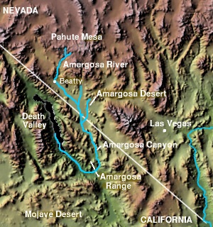
WThe Amargosa Valley is the valley through which the Amargosa River flows south, in Nye County, southwestern Nevada and Inyo County in the state of California. The south end is alternately called the "Amargosa River Valley'" or the "Tecopa Valley." Its northernmost point is around Beatty, Nevada and southernmost is Tecopa, California, where the Amargosa River enters into the Amargosa Canyon.
 W
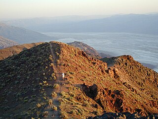
WThe Amargosa Range is a mountain range in Inyo County, California and Nye County, Nevada. The 110-mile (180 km) range runs along most of the eastern side of California's Death Valley, separating it from Nevada's Amargosa Desert. The U-shaped Amargosa River flows clockwise around the perimeter of the range, ending 279 feet (85 m) below sea level in the Badwater Basin.
 W
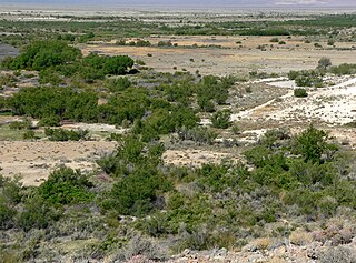
WThe Amargosa River is an intermittent waterway, 185 miles (298 km) long, in southern Nevada and eastern California in the United States. It drains a high desert region, the Amargosa Valley in the Amargosa Desert northwest of Las Vegas, into the Mojave Desert, and finally into Death Valley where it disappears into the ground aquifer. Except for a small portion of its route in the Amargosa Canyon in California and a small portion at Beatty, Nevada, the river flows above ground only after a rare rainstorm washes the region. A 26-mile (42 km) stretch of the river between Shoshone and Dumont Dunes is protected as a National Wild and Scenic River. At the south end of Tecopa Valley the Amargosa River Natural Area protects the habitat.
 W
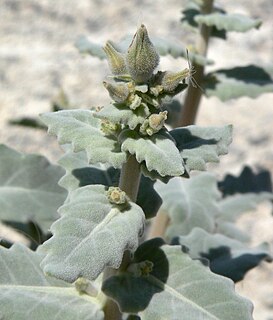
WThe Amargosa toad, previously known as Bufo nelsoni, is a species of toad in the family Bufonidae. It was at one time considered to be a subspecies of the western toad. It is threatened by habitat loss and is classified by the IUCN as being "endangered".
 W
WAmargosa Valley is an unincorporated town located on U.S. Route 95 in Nye County, in the U.S. state of Nevada.
 W
WThe Ash Meadows National Wildlife Refuge is a protected wildlife refuge located in the Amargosa Valley of southern Nye County, in southwestern Nevada. It is directly east of Death Valley National Park, and is 90 mi (140 km) west-northwest of Las Vegas.
 W
WAstragalus phoenix is a rare species of milkvetch known by the common name Ash Meadows milkvetch. It is endemic to Nye County, in southwestern Nevada.
 W
WThe Bare Mountain Range is a mountain range in southern Nye County, Nevada, in the United States. Bare Mountain and Wildcat Peak are the high points of the range.
 W
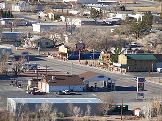
WBeatty is an unincorporated town along the Amargosa River in Nye County in the U.S. state of Nevada. U.S. Route 95 runs through the town, which lies between Tonopah, about 90 miles (140 km) to the north and Las Vegas, about 120 miles (190 km) to the southeast. State Route 374 connects Beatty to Death Valley National Park, about 8 miles (13 km) to the west.
 W
WThe Black Mountains are a mountain range located in the southeastern part of Inyo County, California, within southeastern Death Valley National Park.
 W
WThe Bullfrog Hills are a small mountain range of the Mojave Desert in southern Nye County, southwestern Nevada. Bullfrog Hills was so named from a fancied resemblance of its ore to the color of a bullfrog.
 W
WBullfrog is a ghost town in Nye County, in the U.S. state of Nevada. It is located at the north end of the Amargosa Desert about 4 miles (6.4 km) west of Beatty. Less than 1 mile (1.6 km) north of Bullfrog are the Bullfrog Hills and the ghost town of Rhyolite. The two ghost towns are about 120 miles (190 km) northwest of Las Vegas, 60 miles (97 km) south of Goldfield, and 90 miles (140 km) south of Tonopah.
 W
WState Route 178 is a state highway in the U.S. state of California that exists in two constructed segments. The gap in between segments is connected by various local roads and State Route 190 through Death Valley National Park. The western segment runs from State Route 99 in Bakersfield and over the Walker Pass in the Sierra Nevada to the turnoff for the Trona Pinnacles National Natural Landmark. The eastern segment runs from the southeasterly part of Death Valley to Nevada State Route 372 at the Nevada state line.
 W
WChloride City is a ghost town in Inyo County, California, United States. It is located 8.5 miles (14 km) north-northeast of Beatty Junction, at an elevation of 4,770 ft (1,450 m). The former settlement is now in Death Valley National Park.
 W
WCyprinodon nevadensis is a species of pupfish in the genus Cyprinodon. The species is also known as the Amargosa pupfish, but that name may also refer to one subspecies, Cyprinodon nevadensis amargosae. All six subspecies are or were endemic to very isolated locations in the Mojave Desert of California and Nevada.
 W
WDeath Valley Junction, also known as Amargosa, is a tiny Mojave Desert unincorporated community in Inyo County, California, at the intersection of SR 190 and SR 127, in the Amargosa Valley and just east of Death Valley National Park. The zip code is 92328, the elevation is 2,041 ft (622 m), and the population is fewer than 4.
 W
WThe Death Valley Railroad (DVRR) was a 3 ft narrow gauge railroad that operated in California's Death Valley to carry borax with the route running from Ryan, California and the mines at Lila C, both located just east of Death Valley National Park, to Death Valley Junction, a distance of approximately 20 miles (32 km).
 W
WDevils Hole is a geologic formation located within the Ash Meadows National Wildlife Refuge, in Nye County, Nevada, in the Southwestern United States.
 W
WThe Devils Hole Hills are a mountain range in Nye County, Nevada.
 W
WThe Devils Hole pupfish is a critically endangered species of the family Cyprinodontidae (pupfishes) found only in Devils Hole, a water-filled cavern in the US state of Nevada. It was first described as a species in 1930 and is most closely related to C. nevadensis and the Death Valley pupfish. The age of the species is unknown, with differing analyses offering ranges between one thousand and sixty thousand years. It is a small fish, with maximum lengths of up to 30 mm (1.2 in). Individuals vary in coloration based on age and sex: males are bright metallic blue while females and juveniles are more yellow. A defining trait of this species its lack of pelvic fins. The pupfish consume nearly every available food resource at Devils Hole, including beetles, snails, algae, and freshwater crustaceans, with diet varying throughout the year. It is preyed on by the predaceous diving beetle species Neoclypeodytes cinctellus, which was first observed in Devils Hole in 1999 or 2000. Reproduction occurs year-round, with spikes in the spring and fall. Females produce few eggs, though, and the survivorship from egg to adult is low. Individuals live 10–14 months.
 W
WThe Dumont Hills are a low mountain range in the Mojave Desert, in northeastern San Bernardino County, southern California.
 W
WThe Funeral Mountains are a short, arid mountain range in the United States along the California-Nevada border approximately 100 mi (160 km) west of Las Vegas. The mountains are considered a subrange of the Amargosa Range that form the eastern wall of Death Valley.
 W
WThe Furnace Creek Fault Zone (FCFZ) is a geological fault that is located in Eastern California and southwestern Nevada. The right lateral-moving (dextral) fault extends for some 200 km (120 mi) between a connection with the Death Valley Fault Zone in the Amargosa Valley and northward to a termination in the Fish Lake Valley of southwest Nevada. The northern segment of the FCFZ is also referred to as the Fish Lake Valley Fault Zone. The FCFZ is considered an integral part of the Walker Lane.
 W
WThe Goldwell Open Air Museum is an outdoor sculpture park near the ghost town of Rhyolite in the U.S. state of Nevada. The 7.8-acre (3.2 ha) site is located at the northern end of the Amargosa Valley, about 120 miles (190 km) northwest of Las Vegas, and about 4 miles (6.4 km) west of Beatty off State Route 374. About 5 miles (8.0 km) further west is Death Valley National Park. In addition to the museum, the site includes the Red Barn Art Center, a 2,250-square-foot (209 m2) multi-purpose studio and exhibition space used by artists-in-residence and other artists. Near the art center are the ruins of a jail and other buildings of the historic mining town of Bullfrog.
WThe Johnnie Range is a mountain range in the Mojave Desert, in southern Nye County, Nevada, United States.
 W
WThe Las Vegas and Tonopah Railroad was a 197.9-mile (318.5 km) railroad built by William A. Clark that ran northwest from a connection with the mainline of the San Pedro, Los Angeles and Salt Lake Railroad at Las Vegas, Nevada to the gold mines at Goldfield. The SPLA&SL railroad later became part of the Union Pacific Railroad and serves as their mainline between Los Angeles and Salt Lake City.
 W
WThe Last Chance Range is a mountain range in Nye County, Nevada. It lies immediately north of Pahrump, Nevada, and west of Nevada State Route 160.
WAmargosa Valley is an unincorporated town located on U.S. Route 95 in Nye County, in the U.S. state of Nevada.
 W
WMentzelia leucophylla, known by the common name Ash Meadows blazingstar, is a rare species of flowering plant in the Loasaceae. It is endemic to southwestern Nevada, in the Western United States.
 W
WNitrophila mohavensis is a rare species of flowering plant in the family Amaranthaceae known by the common name Amargosa niterwort. It is endemic to Nye County in southwestern Nevada and Inyo County, in eastern California.
 W
WRhyolite is a ghost town in Nye County, in the U.S. state of Nevada. It is in the Bullfrog Hills, about 120 miles (190 km) northwest of Las Vegas, near the eastern boundary of Death Valley National Park. The town began in early 1905 as one of several mining camps that sprang up after a prospecting discovery in the surrounding hills. During an ensuing gold rush, thousands of gold-seekers, developers, miners and service providers flocked to the Bullfrog Mining District. Many settled in Rhyolite, which lay in a sheltered desert basin near the region's biggest producer, the Montgomery Shoshone Mine.
WThe Sperry Hills are a low mountain range in the northern Mojave Desert—southern Amargosa Desert region, in northeastern San Bernardino County, southern California.
 W
WSpringdale is a privately owned ghost town in Nevada, United States. It is inaccessible to the general public.
WThe Tecopa Hills are a mountain range of the Mojave Desert in extreme eastern Inyo County, California.
 W
WThe Tecopa pupfish is an extinct subspecies of the Amargosa pupfish. The small, heat-tolerant pupfish was endemic to the outflows of a pair of hot springs in the Mojave Desert of California. Habitat modifications and the introduction of non-native species led to its extinction in about 1970.
 W
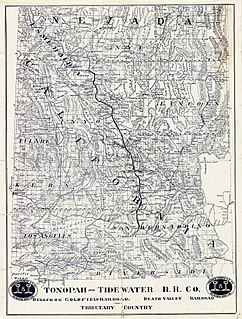
WThe Tonopah and Tidewater Railroad was a former class II railroad that served eastern California and southwestern Nevada.
 W
WYucca Mountain is a mountain in Nevada, near its border with California, approximately 100 miles (160 km) northwest of Las Vegas. Located in the Great Basin, Yucca Mountain is east of the Amargosa Desert, south of the Nevada Test and Training Range and in the Nevada National Security Site. It is the site of the Yucca Mountain nuclear waste repository, which is currently identified by Congressional law as the nation's spent nuclear waste storage facility. However, while licensure of the site through the Nuclear Regulatory Commission is ongoing, political maneuvering led to the site being de-funded in 2010.
 W
WZeltnera namophila, known by the common name spring-loving centaury, is a rare species of flowering plant in the gentian family. It is endemic to the Amargosa Valley, in Nye County, southwestern Nevada.