 W
WAldrington is an area of the city of Brighton and Hove, previously part of the old borough of Hove. For centuries it was meadow land along the English Channel stretching west from the old village of Hove to the old mouth of the River Adur, and it is now a prosperous residential area integrated within Hove.
 W
WThe Bear Road area is a largely residential area in the east of Brighton, part of the English city of Brighton and Hove. Centred on the steep west–east road of that name, it is characterised by terraced houses of the early 20th century, but Brighton's main cemeteries were established here in the 19th century and there is also some industry.
 W
WBevendean is a district of the city of Brighton and Hove, in East Sussex, England.
 W
WBlack Rock is an area of undeveloped land located near Brighton Marina in the city of Brighton and Hove. It was previously the site of a swimming pool that was demolished in the 1970s.
 W
WBrunswick Town is an area in Hove, in the city of Brighton and Hove, England. It is best known for the Regency architecture of the Brunswick estate.
 W
WCarlton Hill is an inner-city area of Brighton, part of the English city and seaside resort of Brighton and Hove. First developed in the early and mid-19th century on steeply sloping farmland east of central Brighton, it grew rapidly as the town became a fashionable, high-class destination. Carlton Hill's population was always poor, though, and by the early 20th century the area was Brighton's worst slum: overcrowding, crime and disease were rife. Extensive slum clearance in the mid-20th century introduced high-density tower blocks, but some old buildings remain: in 2008, Brighton and Hove City Council designated part of Carlton Hill as the city's 34th conservation area. The area now has housing of various styles and ages, large offices and small-scale industry; there are also churches, a school and some open space.
 W
WColdean is a suburb of the English city of Brighton and Hove. Located in the northeast corner of the urban area, it was developed by Brighton Corporation in the 1950s as one of several postwar council estates necessitated by the acute housing shortage in the area after World War II.
 W
WDevil's Dyke is a 100m deep V-shaped valley on the South Downs Way in southern England, near Brighton and Hove. It is part of a Site of Special Scientific Interest, Beeding Hill to Newtimber Hill. Devil's Dyke was a major local tourist attraction in the late 19th and early 20th centuries.
 W
WElm Grove is a mainly residential area of Brighton, part of the English coastal city of Brighton and Hove. The densely populated district lies on a steep hill northeast of the city centre and developed in the second half of the 19th century after the laying out of a major west–east road, also called Elm Grove. Terraced houses, small shops and architecturally impressive public buildings characterise the streetscape: within the area are a major hospital, two churches and a former board school, as well as Brighton's oldest council houses and an interwar council estate.
 W
WHangleton is a residential suburb of Hove, part of the English city and coastal resort of Brighton and Hove. The area was developed in the 1930s after it was incorporated into the borough of Hove, but has ancient origins: its parish church was founded in the 11th century and retains 12th-century fabric, and the medieval manor house is Hove's oldest secular building. The village became depopulated in the medieval era and the church fell into ruins, and the population in the isolated hilltop parish only reached 100 in the early 20th century; but rapid 20th-century development resulted in more than 6,000 people living in Hangleton in 1951 and over 9,000 in 1961. By 2013 the population exceeded 14,000.
 W
WHanover is an area within the city of Brighton and Hove, United Kingdom. It is part of the electoral ward of Hanover & Elm Grove. The population of this ward at the 2011 census was 16,006.
WHollingbury is an area of the city of Brighton and Hove, East Sussex. The area sits high on a hillside across the north of the city, east of Patcham which lies in a valley to the west, Coldean in a valley to the east, and the A27 bypass forming the northern limit. To the south it blends into the leafy Surrenden area and the busy Fiveways local shopping area.
 W
WHollingdean is a district in the city of Brighton & Hove. The Ward is called Hollingdean and Stanmer with a population of 15,681 at the 2011 Census.
 W
WKemp Town is a 19th-century residential estate in the east of Brighton in East Sussex, England, UK. Conceived and financed by Thomas Read Kemp, it has given its name to the larger Kemptown region of Brighton. The majority of the original estate is now demarcated by the modern Kemp Town Conservation Area as defined by the local authority, Brighton and Hove City Council.
 W
WKemptown is a small community running along the King's Cliff to Black Rock in the east of Brighton, East Sussex, England.
 W
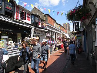
WThe Lanes are a collection of narrow lanes in Brighton, in the city of Brighton and Hove famous for their small shops and narrow alleyways.
 W
WMile Oak is a locality forming the northern part of the former parish of Portslade in the northwest corner of the city of Brighton and Hove, England. Now mostly residential, but originally an area of good-quality agricultural land, it covers the area north of Portslade village as far as the urban boundary.
 W
WMontpelier is an inner suburban area of Brighton, part of the English city and seaside resort of Brighton and Hove. Developed together with the adjacent Clifton Hill area in the mid-19th century, it forms a high-class, architecturally cohesive residential district with "an exceptionally complete character". Stucco-clad terraced housing and villas predominate, but two of the city's most significant Victorian churches and a landmark hospital building are also in the area, which lies immediately northwest of Brighton city centre and spreads as far as the ancient parish boundary with Hove.
 W
WMoulsecoomb is a suburb of Brighton, part of the city of Brighton and Hove. The electoral ward is called Moulsecoomb and Bevendean. It is located on the northeastern side of Brighton, around the A270 Lewes Road, between the areas of Coldean and Bevendean and approximately 2 1⁄4 miles (3.6 km) north of the seafront. The eastern edges of the built-up area adjoin Falmer Hill, on the South Downs. As the suburb is so large, and developed over an extended period, it is often divided into smaller sections on maps and similar: North Moulsecoomb, East Moulsecoomb and Moulsecoomb itself.
 W
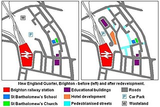
WThe New England Quarter is a mixed-use development in the city of Brighton and Hove, England. It was built between 2004 and 2008 on the largest brownfield site in the city, adjacent to Brighton railway station. Most parts of the scheme have been finished, but other sections are still being built and one major aspect of the original plan was refused planning permission.
 W
WNorth Laine is a shopping and residential district of Brighton, on the English south coast. Once a slum area, its many pubs, cafés, theatres and museums now make it seen as Brighton's bohemian and cultural quarter.
 W
WThe Old Steine is a thoroughfare in central Brighton, East Sussex, and is the southern terminus of the A23. The southern end leads to Marine Parade, the Brighton seafront and the Palace Pier. The Old Steine is also the site of a number of City Centre bus stops for Brighton buses. The Royal Pavilion is located immediately to the north of the Old Steine.
 W
WThe Old Steine Gardens in Brighton, Brighton and Hove, East Sussex, England, adjacent to the Old Steine thoroughfare, are the site of several monuments of national historic significance.
 W
WOvingdean is a small, formerly agricultural, village in the east of greater Brighton and Hove, East Sussex, England.
 W
WPatcham is an area of the city of Brighton & Hove, about 3 miles (5 km) north of the city centre. It is bounded by the A27 to the north, Hollingbury to the east and southeast, Withdean to the south and the Brighton Main Line to the west. The A23 passes through the area.
 W
WPortslade is a western suburb of the city of Brighton and Hove, England. Portslade Village, the original settlement a mile inland to the north, was built up in the 16th century. The arrival of the railway from Brighton in 1840 encouraged rapid development of the coastal area and in 1896 the southern part, formerly known as Copperas Gap, was granted urban district status and renamed Portslade-by-Sea, making it distinct from Portslade Village. After World War II the district of Mile Oak to the north was added. Today, Portslade is bisected from east to west by the old A27 road between Brighton and Worthing, each part having a distinct character.
 W
WPrestonville is a largely residential area in the northwest of Brighton, part of the English city of Brighton and Hove. It covers a long, narrow and steeply sloping ridge of land between the Brighton Main Line and Dyke Road, two major transport corridors which run north-northwestwards from the centre of Brighton. Residential development started in the 1860s and spread northwards, further from central Brighton, over the next six decades. The area is characterised by middle-class and upper-middle-class housing in various styles, small-scale commercial development and long eastward views across the city. Two Anglican churches serve Prestonville—one at each end of the area—and there are several listed buildings.
 W
WRoedean is a village in the city of Brighton and Hove, England, UK, immediately to the east of the seaside resort of Brighton.
 W
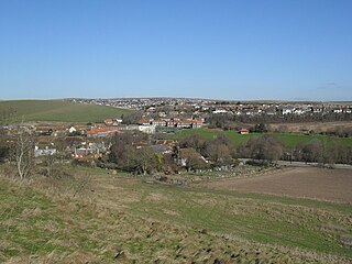
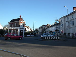
WRottingdean is a village in East Sussex, on the south coast of England. It borders the villages of Saltdean, Ovingdean and Woodingdean, and has a historic centre, often the subject of picture postcards.
 W
WRound Hill is an inner suburban area of Brighton, part of the coastal city of Brighton and Hove in England. The area contains a mix of privately owned and privately rented terraced housing, much of which has been converted for multiple occupancies, and small-scale commercial development. It was developed mostly in the late 19th century on an area of high land overlooking central Brighton and with good views in all directions, the area became a desirable middle-class suburb—particularly the large terraced houses of Roundhill Crescent and Richmond Road, and the exclusive Park Crescent—and within a few decades the whole of the hill had been built up with smaller terraces and some large villas.
 W
WSaltdean is a coastal village in the city of Brighton and Hove, with part outside the city boundary in Lewes district. Saltdean is approximately 5 miles (8 km) east of central Brighton, 5 miles (8 km) west of Newhaven, and 6 miles (9.7 km) south of Lewes. It is bordered by farmland and the South Downs National Park.
 W
WSeven Dials is a district surrounding a major road junction of the same name in Brighton, in the city of Brighton and Hove. It is located on high ground just northwest of Brighton railway station, south of the Prestonville area, and approximately ¾ mile north of the seafront.
 W
WStanmer is a small village on the eastern outskirts of Brighton, in East Sussex, England.
 W
WWest Blatchington is an area in Hove, East Sussex, England.
 W
WWest Hill is an area of Brighton and Hove, East Sussex situated on the east-facing hill rising west from Brighton railway station towards Seven Dials. The area is bounded by Dyke Road to the west, by the curve of the railway line and the station to the north and east, and by modern development along Queen's Road to the south-east.
 W
WWestdene is an area of the city of Brighton and Hove, East Sussex. It is an affluent northern suburb of the city, west of Patcham, the A23 and the London to Brighton railway line, north of Withdean and northeast of West Blatchington. It is on the Brighton side of the historic parish boundary between Brighton and Hove and is served by Preston Park railway station. It is known for its greenery and woodland and is very close to the South Downs, from which it is separated by the Brighton Bypass, and was built on the slopes of two hills.
 W
WWhitehawk is a suburb in the east of Brighton, part of the English city of Brighton and Hove. It is located south of Bevendean and north of Brighton Marina. The area is a large, modern housing estate built in a downland dry valley historically known as Whitehawk Bottom. The estate was originally developed by the local council between 1933 and 1937 and included nearly 1,200 residences. Subsequently, the Swanborough flats were built in 1967, and during the 1970s and 1980s much of the estate was rebuilt by altering the road layouts and increasing the number of houses. Whitehawk is part of the East Brighton ward of Brighton and Hove City Council, represented by Nancy Platts (Labour), Nichole Brennan (Labour) and Gill Williams (Labour).
 W
WWithdean is a former village, now part of Brighton and Hove, East Sussex.
 W
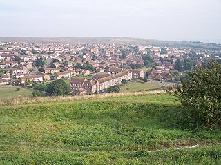
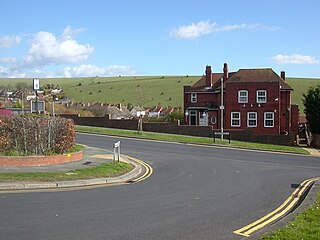
WWoodingdean is an eastern suburb of the city of Brighton and Hove, East Sussex, separated from the main part of the city by downland and the Brighton Racecourse.