 W
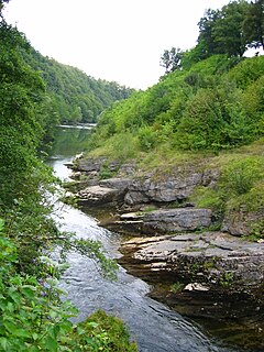
WBioštica is a small river in central-northern part of Bosnia and Herzegovina. The Bioštica meets the Stupčanica at the small town of Olovo. It is the main, left tributary of the Krivaja River. Part of the Bioštica river canyon, "Zeleni Vir", is protected natural monument of Bosnia and Herzegovina. From confluence with the Kaljina river, Bioštica runs toward Olovo for the next 12.3 kilometers.
 W
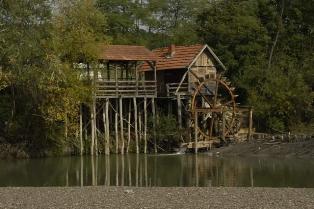
WThe Buna is a short river in Bosnia and Herzegovina; it is a left bank tributary of the Neretva. Its source, a strong karstic spring, is near the village Blagaj, southeast of Mostar. It is best known for the Buna Spring, one of the strongest springs in Europe and extremely cold water. The Buna flows west for approximately 9 km, starts at Blagaj and meandering through villages Blagaj, Kosor, Malo Polje, Hodbina and joins the Neretva at settlement Buna. The Bunica river is main left bank tributary of the Buna.
 W
WThe Bunica is a short river in Bosnia and Herzegovina and a left bank tributary of the Buna. Its source, located in a place called Parila under sharp cliffs between the two villages of Hodbina and Malo Polje, is 14 km south from Mostar. It is a very deep and strong karstic spring and difficult to access. Together with the Buna river, it flows west for approximately 10 km and joins the Neretva river near Buna village. The Bunica is a main tributary of the Buna.
 W
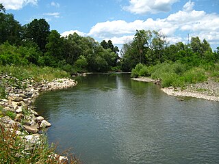
WThe Ćehotina, also Ćeotina, Ćotina or Čehotina, is a 125 kilometres (78 mi) long river in Montenegro and Bosnia and Herzegovina, it is a right bank tributary of the Drina river.
 W
WCrna River is left tributary of Vrbas. It arises from Malo Lake of Balkana, Mrkonjić Grad Municipality. The lake fed by streams Cjepalo and Skakavac with mountain Lisina, as well as sublacustric sources under the Veliko Lake.
 W
WThe Cvrcka is a river which flows through Bosnia, the largest left bank tributary of Vrbanja river.
 W
WDabar is the river in Bosanska Krajina region, in Bosnia and Herzegovina. It is a left tributary of the Sana river. The river Dabar emerges from Dabar cave, and runs for 4,5 kilometres eastward toward the Sana river. The two river meat near Sanski Most, just 5 kilometres upstream from the town.
 W
WDoljanka is a right tributary of Neretva river in North Herzegovina, Bosnia and Herzegovina.
 W
WDrinjača is a left tributary of the Drina in eastern Bosnia and Herzegovina. It rises on the mountain of Konjuh 15 km northeast of Kladanj at an elevation of about 1,000 m and ends after 87.5 km in the Drina, south of Zvornik. The catchment area covers 1,091 km².
 W
WThe Duboka (Дубoкa) river is left tributary of the Vrbanja river in Bosnia. It rises under Međugorje Mountain (1,116 m), and Bojići village, on around 1,030 meters above sea level. It grows strong after large Gladno vrelo. To its mouth Duboka receives the abundance of streams, brooks and coastal streams.
 W
WFojnička River is a left tributary of the Bosna in Bosnia and Herzegovina. It flows for 46 kilometres with a basin area of 727 km². The Željeznica and the Lepenica are tributaries of the Fojnička River. It is among last remaining sanctuaries for huchen in the Bosna river basin, others being the Krivaja, and possibly the Lašva and the Željeznica.
 W
WGlina is a river in central Croatia and Bosnia and Herzegovina, a right tributary of Kupa. It is 112 kilometres (70 mi) long and its basin covers an area of 1,427 square kilometres (551 sq mi).
 W
WThe Korana is a river in central Croatia and west Bosnia and Herzegovina. The river has a total length of 138.6 km (86.1 mi) and watershed area of 2,301.5 km2 (888.6 sq mi).
 W
WThe Krivaja is a river in central-northern parts of Bosnia and Herzegovina, and a right tributary of the Bosna River. Its source is confluence of the Stupčanica and the Bioštica rivers at the western outskirts of town of Olovo. From there the Krivaja flows through the scenic gorge between mountains of Zvijezda and Konjuh (mountain), with lot of small mountain streams and small rivers inflow from both sides. Finally, the Krivaja meets the Bosna River at the vicinity of town of Zavidovići.
 W
WThe Krupa river is a left tributary of the river Neretva and the main water current of Hutovo Blato, which leads the waters from Gornje Blato and Svitavsko lake into the Neretva river near Dračevo. The length of Krupa is 9 km with an average depth of 5 meters. Krupa does not have an actual source, but is actually an arm of Deransko lake. Also, the Krupa is a unique river in Europe, because the river flows both ways. It flows 'normally' from the 'source' to the mouth and from the mouth to the 'source'. This happens when, due to high water level and large quantity of water, river Neretva pushes the Krupa river in opposite direction.
 W
WThe Lašva is a river in Central Bosnia, Bosnia and Herzegovina. It is a left tributary of the Bosna.
 W
WLepenica is a small river in central Bosnia and Herzegovina. The Lepenica is right and main tributary of the Fojnička River. Its source is under the mountain of Ivan and runs through Kiseljak before its confluence with the Fojnička River.
 W
WLištica is a sinking river in Bosnia and Herzegovina. It is listed as the second coldest river in Europe, and is prone to constant flooding mostly during winter. The Lištica river connects with the Borak wellspring, which rises at the base of the mountainside on the outskirts of town of Široki Brijeg. The town of Široki Brijeg was named Lištica after the Lištica River during the SFR Yugoslavia (1945–1990) but changed its name when the country dissolved back into Bosnia and Herzegovina.
 W
WMostarska Bijela or simply Bijela is a mountain creek and gorge in Bosnia and Herzegovina. Despite its low discharge and relatively short flow, this river takes a significant place in Bosnia and Herzegovina's Dinaric karst's geology and hydrology.
 W
WPlava Voda is a large spring, which creates approximately 350 meters long eponymous river, in Travnik, Bosnia and Herzegovina. It rises under Vlašić mountain, just below Travnik Castle, in the center of Old Town of Travnik.
 W
WThe Prača is a left tributary of the Drina in eastern Bosnia and Herzegovina. It source is in Pale, Bosnia and Herzegovina at an altitude of 1540 m. After 55 km it flows into the Drina in Ustiprača.
 W
WRadobolja is a river in Bosnia and Herzegovina. It is five kilometers long and its spring is located below the Mikuljača hill in Mostar's suburb of Ilići. Radobolja flows through Mostar and flows into the Neretva River near the Old Bridge. During the Ottoman rule water from Radobolja was used for irrigation and drinking, however today's Radobolja is polluted due to discharge of waste-water.
 W
WRakitnica is the main tributary of the first section of the Neretva river, also called Upper Neretva (Bosnian: Gornja Neretva). It meets Neretva from the right, flowing from north to south, between Bjelašnica and Visočica mountains.
 W
WRama is a river in Bosnia and Herzegovina, and a major tributary of the Neretva. It joins it from the right by discharging into Neretva's artificial reservoir, Jablaničko lake, at place called Marina Pećina, near village of Gračac, between location of underground powerhouse of Rama Hydroelectric Power Station and Jablanica Dam, depending on water level in Jablaničko lake, some 15 kilometers upstream from Jablanica.
 W
WSanica is a minor river in the north-west part of Bosnia and Herzegovina. It flows into the Sana near Vrhpolje. The village Sanica got its name from the river.
 W
WThe Sava Dolinka is a headwater of the Sava River in northwestern Slovenia. The 45 kilometres (28 mi) long Sava Dolinka starts as Nadiža Creek in the Planica Valley under Mount Zadnja Ponca in the Julian Alps, at an elevation of 1222 m, close to the Italian border. The stream goes underground soon after its source and breaks out again after 5 km at an elevation of 842 m in Zelenci, near Kranjska Gora. The Sava Dolinka flows through Kranjska Gora, Gozd Martuljek, Jesenice, between Bled and Breg, and past the town of Lesce. The first in a series of hydroelectric power plants on the river, the Moste Hydro Power Plant, is located near Žirovnica. It merges with the second major headwater of the Sava, the Sava Bohinjka, at Radovljica. A notable tributary of the Sava Dolinka is the Radovna, which flows through the Vintgar Gorge near Bled.
 W
WThe Spreča is a river of northeastern Bosnia and Herzegovina, a tributary of the Bosna. Its source is located in the village of Snagovo in Zvornik municipality, and it reaches the Bosna at the city of Doboj. A damming of the Spreča in the municipality of Lukavac forms Modrac Lake. The 138.8-kilometre-long (86.2 mi) river also flows through the town of Gračanica.
 W
WČude Canyon is a short but deep canyon created by the Stupčanica river in central-northerneastern part of Bosnia and Herzegovina, in Olovo municipality. The Stupčanica cuts through steep slopes of Gradac, on the right bank, and Krševi, on the left, thus creating over a half of kilometer deep canyon, only 3.8 kilometers long, and just few hundreds meters wide at the rim levels, while at the river level canyon is often only 2-3 meters wide. The "Čude Canyon" is protected natural monument of Bosnia and Herzegovina.
WStupčanica is a small river in central-northern part of Bosnia and Herzegovina. The Stupčanica meets with the Bioštica at the small town of Olovo. It is a right tributary of the Krivaja River. The Stupčanica river canyon, "Čude Canyon", is protected natural monument of Bosnia and Herzegovina.
 W
WSturba is a river in Western Bosnia and Herzegovina, and flows through Livanjsko Polje near Livno in Bosnia and Herzegovina.
 W
WThe Sutjeska is a 35 km-long river in eastern Bosnia and Herzegovina. It is a tributary of the Drina river, which it meets south of Foča. The literal meaning of "sutjeska" is "gorge, canyon".
 W
WUkrina is a river in the Central Bosnia, Bosnia and Herzegovina, right tributary of the river Sava. Its mouth is 3 km north from settlement Koraće and 10 km southwest of Brod.
 W
WUnac River is a sinking river in Bosnia and Herzegovina. It rises beneath Šator mountain, flows through the municipality of Drvar and finally meets Una River in Martin Brod. Also runs through two deep and rugged karstic canyons and it is dammed to form small Prekajsko Lake and larger Župica Lake, before it reach town of Drvar.
 W
WUsora is a river in central-northern Bosnia and Herzegovina. It begins at the confluence of two smaller Usora rivers, Mala Usora and Velika Usora, at the town of Teslić. Usora runs for some 20 km northeast of Teslić, and becomes a left tributary of the Bosna River, south of Doboj. Its total length is 77.0 km (47.8 mi).
 W
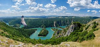
WThe Uvac is an international trans-boundary river, rising under Golija mountain and Pešter plateau, then flowing through southwestern Serbia and cross into eastern Bosnia and Herzegovina where, after 115 km, it finally meets the Lim river from the right, however, before it empties into the Lim, for a 10 kilometers Uvac forms the border between two countries. Also, while meandering through Serbia, Uvac loosely makes the northern border of the Raška region, too.
 W
WThe Vrbas is a major river with a length of 250 kilometres (160 mi), in western Bosnia and Herzegovina. It is a right tributary of the Sava river. The city of Banja Luka is located on the river banks.
WThe Vrljika is short sinking river in Croatia and Bosnia and Herzegovina, belonging to Neretva River basin. Its source is located on the outskirts of village Proložac near town of Imotski, Croatia. The Vrljika River is home of endangered endemic Softmouth' trout, also known as Adriatic trout.
 W
WŽabljak is a river near Livno in Western Bosnia, Bosnia and Herzegovina. It flows for roughly 6.6 kilometers westward through Livanjsko Polje before its confluence with the Bistrica, just upstream from beginning of its section with artificially created riverbed, from where river begins to turn southward toward Buško Blato.
 W
WThe Željeznica is a river in Bosnia and Herzegovina, which rises at the foot of the Treskavica Mountain. It has a number of rapids and whirlpools, including those of Turovi. Kazani is regarded the most attractive place in the canyon, where round hollows, "kettles", give the impression of boiling water. The kettles are about half to one meter deep and 0,30 to 0,70 cm wide in radius, and they are frequent in the riverbed.