 W
WThe exploration of North America by non-indigenous people was a continuing effort to map and explore the continent and advance the economic interests of said non-indigenous peoples of North America. It spanned centuries, and consisted of efforts by numerous people and expeditions from various foreign countries to map the continent. See also the European colonization of the Americas
 W
WA Relation of a Voyage made in the Years 1695, 1696, 1697 on the Coasts of Africa, Streights of Magellan, Brasil, Cayenna, and the Antilles, by a Squadron of French Men of War, under the Command of M. de Gennes, written by François Froger, published in French and in English in 1698, relates the three years of travel of this young French explorer, engineer and hydrographer, who was nineteen years old at the date of departure. The author describes the colonies and harbors he visited, the people he met as well as the fruits, plants and animals he discovered.
 W
WAjacán – variants include Xacan, Jacan, Iacan, Axaca and Axacam – was a short-lived Spanish settlement, between 1570 and 1571, near Chesapeake Bay, in what would later become Virginia.
 W
WThe Dutch West India Company was a chartered company of Dutch merchants as well as foreign investors. Among its founders was Willem Usselincx (1567–1647) and Jessé de Forest (1576–1624). On 3 June 1621, it was granted a charter for a trade monopoly in the Dutch West Indies by the Republic of the Seven United Netherlands and given jurisdiction over Dutch participation in the Atlantic slave trade, Brazil, the Caribbean, and North America. The area where the company could operate consisted of West Africa and the Americas, which included the Pacific Ocean and the eastern part of New Guinea. The intended purpose of the charter was to eliminate competition, particularly Spanish or Portuguese, between the various trading posts established by the merchants. The company became instrumental in the largely ephemeral Dutch colonization of the Americas in the seventeenth century. From 1624 to 1654, in the context of the Dutch-Portuguese War, the GWC held Portuguese territory in northeast Brazil, but they were ousted from Dutch Brazil following fierce resistance.
 W
WEngineer Cantonment is an archaeological site in Washington County, in the state of Nebraska in the Midwestern United States. Located in the floodplain of the Missouri River near present-day Omaha, Nebraska, it was the temporary winter camp of the scientific party of the Yellowstone Expedition. From October 1819 to June 1820, the party studied the geology and biology of the vicinity, and met with the local indigenous peoples. Their eight-month study of the biota has been described as "the first biodiversity inventory undertaken in the United States".
 W
WFort Bonneville was a fortified winter camp and fur trading post near present-day Pinedale, Wyoming established in 1832 by Captain Benjamin Bonneville. Bonneville's party was engaged in the exploration of Wyoming, crossing the South Pass with 110 men and about 20 wagons. Bonneville completed the stockade on the Green River on August 9, 1832. Heavy fall snows caused Bonneville to reconsider the site, and the party abandoned it, leading the place to become known as Bonneville's Folly or Fort Nonsense. Bonneville moved on to the Salmon River in Idaho for the winter. The Green River site functioned as a rendezvous until the party returned east in 1835.
 W
WThe Geological Exploration of the Fortieth Parallel was a geological survey made by order of the Secretary of War according to acts of Congress of March 2, 1867, and March 3, 1869, under the direction of Brig. and Bvt. Major General A. A. Humphreys, Chief of Engineers, by Clarence King, U. S. geologist. More commonly known as the Fortieth Parallel Survey, the survey conducted field work from 1867 to 1872, exploring the area along the fortieth parallel north from northeastern California, through Nevada, to eastern Wyoming.
 W
WThe Great Northern Expedition or Second Kamchatka expedition was one of the largest exploration enterprises in history, mapping most of the Arctic coast of Siberia and some parts of the North American coastline, greatly reducing "white areas" on maps. It was conceived by Russian Emperor Peter I the Great, but implemented by Russian Empresses Anna and Elizabeth. The main organiser and leader of the expedition was Vitus Bering, who earlier had been commissioned by Peter I to lead the First Kamchatka expedition. The Second Kamchatka Expedition lasted roughly from 1733–1743 and later was called the Great Northern Expedition due to the immense scale of its achievements.
 W
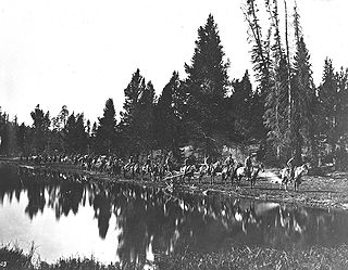
WThe Hayden Geological Survey of 1871 explored the region of northwestern Wyoming that later became Yellowstone National Park in 1872. It was led by geologist Ferdinand Vandeveer Hayden. The 1871 survey was not Hayden's first, but it was the first federally funded, geological survey to explore and further document features in the region soon to become Yellowstone National Park and played a prominent role in convincing the U.S. Congress to pass the legislation creating the park. In 1894, Nathaniel P. Langford, the first park superintendent and a member of the Washburn-Langford-Doane Expedition which explored the park in 1870, wrote this about the Hayden expedition:We trace the creation of the park from the Folsom-Cook expedition of 1869 to the Washburn expedition of 1870, and thence to the Hayden expedition of 1871, Not to one of these expeditions more than to another do we owe the legislation which set apart this "pleasuring-ground for the benefit and enjoyment of the people"
 W
WThis is a bibliography of literature dealing with the Lewis and Clark Expedition.
 W
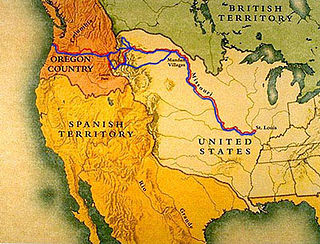
WThe Lewis and Clark Expedition from August 31, 1803, to September 25, 1806, also known as the Corps of Discovery Expedition, was the United States expedition to cross the newly acquired western portion of the country after the Louisiana Purchase. The Corps of Discovery was a select group of U.S. Army and civilian volunteers under the command of Captain Meriwether Lewis and his close friend Second Lieutenant William Clark. The expedition made its way westward, and crossed the Continental Divide of the Americas before reaching the Pacific Coast.
 W
WThe Mackenzie River expedition of 1825–1827 was the second of three Arctic expeditions led by explorer John Franklin and organized by the Royal Navy. It had as its goal the exploration of the North American coast between the mouths of the Mackenzie and Coppermine rivers and the Bering Strait, in what is now present-day Alaska, Yukon, the Northwest Territories, and Nunavut. Franklin was accompanied by George Back and John Richardson, both of whom he had previously collaborated with during the disastrous Coppermine expedition of 1819–1821. Unlike Franklin's previous expedition, this one was largely successful, and resulted in the mapping of more than 1,000 kilometres (620 mi) of new coastline between the Kent Peninsula and Prudhoe Bay, Alaska, an area that until then had remained largely unexplored by Europeans.
 W
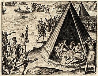
WThe Narváez expedition was a Spanish journey of exploration and colonization started in 1527 that intended to establish colonial settlements and garrisons in Florida. The expedition was initially led by Pánfilo de Narváez, who died in 1528. Many more people died as the expedition traveled west along the explored Gulf Coast of the present-day United States and into the American Southwest. Only four of the expedition's original members survived, reaching Mexico City in 1536. These survivors were the first known Europeans, and the first African, to see the Mississippi River, and to cross the Gulf of Mexico and Texas.
 W
WNew Albion, also known as Nova Albion, was the name of the continental area north of Mexico claimed by Sir Francis Drake for England when he landed on the North American west coast in 1579. This claim became the justification for English charters across America to the Atlantic coast and soon influenced further national expansion projects on the continent. Today, Drake's landing site is known as Point Reyes, California, a marine environment which is the setting of several small towns, ranches, and Point Reyes National Seashore.
 W
WThe Northwest Passage (NWP) is the sea route between the Atlantic and Pacific oceans through the Arctic Ocean, along the northern coast of North America via waterways through the Canadian Arctic Archipelago. The eastern route along the Arctic coasts of Norway and Siberia is accordingly called the Northeast Passage (NEP).
 W
WThe Pacific Railroad Surveys (1853–1855) consisted of a series of explorations of the American West to find possible routes for a transcontinental railroad across North America. The expeditions included surveyors, scientists, and artists and resulted in an immense body of data covering at least 400,000 square miles (1,000,000 km2) on the American West. "These volumes... constitute probably the most important single contemporary source of knowledge on Western geography and history and their value is greatly enhanced by the inclusion of many beautiful plates in color of scenery, native inhabitants, fauna and flora of the Western country." Published by the United States War Department from 1855 to 1860, the surveys contained significant material on natural history, including many illustrations of reptiles, amphibians, birds, and mammals. In addition to describing the route, these surveys also reported on the geology, zoology, botany, paleontology of the land as well as provided ethnographic descriptions of the Native peoples encountered during the surveys.
 W
WThe British North American Exploring Expedition, commonly called the Palliser expedition, explored and surveyed the open prairies and rugged wilderness of western Canada from 1857 to 1860. The expedition was led by John Palliser, and accompanied by a party of four other men: James Hector, Eugène Bourgeau, Thomas Blakiston and John W. Sullivan. With the support of the British government and the Royal Geographical Society it became an official expedition that provided research and information on the landscape of western Canada. The purpose of the expedition was to gather scientific information on Rupert's Land, including information on the geography, climate, soil, flora and fauna, to discover its capabilities for settlement and transportation. This was the first detailed and scientific survey of the region from Lake Superior to the southern passes of the Rocky Mountains. The expedition provided a better understanding about western Canada and the new observations and knowledge about the landscape was influential in the expansion and development in the western prairies. The information that was gathered impacted the changes in the economy, settlement, transportation, indigenous communities and the expansionist campaign.
 W
WThe Pike Expedition was a military party sent out by President Thomas Jefferson and authorized by the United States government to explore the south and west of the recent Louisiana Purchase. Roughly contemporaneous with the Lewis and Clark Expedition, it was led by United States Army Lieutenant Zebulon Pike, Jr. who was promoted to captain during the trip. It was the first official American effort to explore the western Great Plains and the Rocky Mountains in present-day Colorado. Pike contacted several Native American tribes during his travels and informed them that the US now claimed their territory. The expedition documented the United States' discovery of Tava which was later renamed Pikes Peak in honor of Pike. After splitting up his men, Pike led the larger contingent to find the headwaters of the Red River. A smaller group returned safely to the US Army fort in St. Louis, Missouri before winter set in.
 W
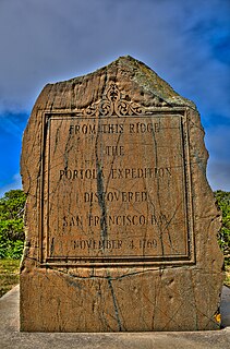
WThe Portolà expedition was a Spanish voyage of exploration in 1769–1770 that was the first recorded European land entry and exploration of the interior of the present-day U.S. state of California. It was led by Gaspar de Portolà, governor of Las Californias, the Spanish colonial province that included California, Baja California, and other parts of present-day Mexico and the United States. The expedition led to the founding of Alta California and contributed to the solidification of Spanish territorial claims in the disputed and unexplored regions along the Pacific coast of North America.
 W
WThis timeline of the Portolá expedition tracks the progress during 1769 and 1770 of the first European exploration-by-land of north-western coastal areas in what became Las Californias, a province of Spanish colonial New Spain. Later, the region was administratively-split into Baja and Alta. The first section of the march was on the Baja California peninsula, and the northern section of the expedition's trail was in today's U.S.A. state of California.
 W
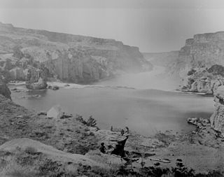
WThe Powell Geographic Expedition of 1869, led by American naturalist John Wesley Powell, was the first thorough cartographic and scientific investigation of long segments of the Green and Colorado rivers in the southwestern United States, including the first recorded passage of white men through the entirety of the Grand Canyon. The expedition, which lasted approximately three months during the summer of 1869, embarked from Green River Station, Wyoming Territory and traveled downstream through parts of the present-day states of Colorado, Utah, and Arizona before reaching the confluence of the Colorado and Virgin rivers in present-day Nevada. Despite a series of hardships, including losses of boats and supplies, near-drownings, and the eventual departures of several crew members, the voyage produced the first detailed descriptions of much of the previously unexplored canyon country of the Colorado Plateau.
 W
WThe Raynolds Expedition was a United States Army exploring and mapping expedition intended to map the unexplored territory between Fort Pierre, Dakota Territory and the headwaters of the Yellowstone River. The expedition was led by topographical engineer Captain William F. Raynolds.
 W
WIn May 1792, American merchant sea captain Robert Gray sailed into the Columbia River, becoming the first recorded European to navigate into it. The voyage, conducted on Columbia Rediviva, a privately-owned ship, was eventually used as a basis for the United States' claim on the Pacific Northwest, although its relevance to the claim was disputed by the British. As a result of the outcome the river was afterwards named after the ship. Gray spent nine days on the river trading fur pelts before sailing out of the river.
 W
WThe Sea of the West, or Mer de l'Ouest, was a geographic misconception of an inland sea in the Pacific Northwest that appeared on many maps of the 18th century. The depiction was particularly common on French maps. The sea was supposed to be connected to the Pacific Ocean by at least one strait. Many different conjectures about the sea's shape, size, and position appeared on maps of the period.
 W
WSpanish claims to the West Coast of North America date to the papal bull of 1493, and the Treaty of Tordesillas. In 1513, this claim was reinforced by Spanish explorer Vasco Núñez de Balboa, the first European to sight the Pacific Ocean, when he claimed all lands adjoining this ocean for the Spanish Crown. Spain only started to colonize the claimed territory north of present-day Mexico in the 18th century, when it settled the northern coast of Las Californias (California).
 W
WThe Swedish South Company, also known as the Company of New-Sweden, was a trading company from Sweden founded in 1626, that supported the trade between Sweden and its colony New Sweden, in North America. The colony was envisioned by its founding father Willem Usselincx; it was to become the first Swedish transoceanic trading project.
 W
WThe Discovery of America is a trilogy written by the German author and educator Joachim Heinrich Campe (1746-1818). It was originally published in 1781/82 as Die Entdekkung von Amerika - ein angenehmes und nützliches Lesebuch für Kinder und junge Leute and deals with the discovery, early exploration and conquest of America by focusing on one explorer in each volume: Christopher Columbus is treated first, followed by Hernán Cortés and finally Francisco Pizarro. The work is counted among the first books of specific children's literature, directly targeting children and adolescents as its main audience, and Campe said to have "set the standard for German children's literature." The trilogy is defined by its author's involvement in the German educational movement of philanthropinism and has been a great success, also being translated into several languages.
 W
WThe Jones Expedition of 1873 was a survey completed during the summer of 1873 with the official purpose of finding a wagon route between the Union Pacific Railroad in the southern part of the Wyoming Territory and Yellowstone National Park.
 W
WJames Cook's third and final voyage took the route from Plymouth via Cape Town and Tenerife to New Zealand and the Hawaiian Islands, and along the North American coast to the Bering Strait.
 W
WThe National Geodetic Survey (NGS), formerly the United States Survey of the Coast (1807–1836), United States Coast Survey (1836–1878), and United States Coast and Geodetic Survey (USC&GS) (1878–1970), is a United States federal agency that defines and manages a national coordinate system, providing the foundation for transportation and communication; mapping and charting; and a large number of applications of science and engineering. Since its foundation in its present form in 1970, it has been part of the National Oceanic and Atmospheric Administration (NOAA), of the United States Department of Commerce.
 W
WThe United States and Mexican Boundary Survey (1848–1855) determined the border between the United States and Mexico as defined in the Treaty of Guadalupe Hidalgo, which had ended the Mexican–American War. The results of the survey were published in the three volumes entitled Report on the United States and Mexican boundary survey, made under the direction of the secretary of the Interior by William H. Emory (1857-1859).
 W
WThe U.S. Army Corps of Topographical Engineers was a branch of the United States Army authorized on 4 July 1838. It consisted only of officers who were handpicked from West Point and was used for mapping and the design and construction of federal civil works such as lighthouses and other coastal fortifications and navigational routes. Members included such officers as George Meade, John C. Frémont and Stephen Long. It was merged with the United States Army Corps of Engineers on 31 March 1863, at which point the Corps of Engineers also assumed the Lakes Survey for the Great Lakes. In the mid-19th century, Corps of Engineers' officers ran Lighthouse Districts in tandem with U.S. Naval officers.
 W
WThe United States Exploring Expedition of 1838–1842 was an exploring and surveying expedition of the Pacific Ocean and surrounding lands conducted by the United States. The original appointed commanding officer was Commodore Thomas ap Catesby Jones. Funding for the original expedition was requested by President John Quincy Adams in 1828, however, Congress would not implement funding until eight years later. In May 1836, the oceanic exploration voyage was finally authorized by Congress and created by President Andrew Jackson.
 W
WThe United States Geological Survey is a scientific agency of the United States government. The scientists of the USGS study the landscape of the United States, its natural resources, and the natural hazards that threaten it. The organization's work spans the disciplines of biology, geography, geology, and hydrology. The USGS is a fact-finding research organization with no regulatory responsibility.
 W
WBetween 1492 and 1504, Italian explorer Christopher Columbus led four Spanish-based transatlantic maritime expeditions to the Americas, a continental landmass which was virtually unknown to and outside of the Old World (Afro-Eurasia). These voyages to America led to the widespread knowledge of its existence. This breakthrough inaugurated the period known as the Age of Discovery, which saw the colonization of the Americas, a related biological exchange, and trans-Atlantic trade. These events, the effects and consequences of which persist to the present, are sometimes cited as the beginning of the modern era.
WRichard Russell Waldron was a purser "and special agent" in the Wilkes Expedition, together with younger brother Thomas Westbrook Waldron (consul). Several landmarks were named after him or his brother. After the expedition was completed Waldron enjoyed some popularity and influence in Washington, D.C.
 W
WThomas Westbrook Waldron was a captain's clerk on the Wilkes Expedition, and the first United States consul to Hong Kong. His service to the United States consular service was honoured by Secretary of State Hillary Clinton during a ceremony in 2009.
 W
WThe Yellowstone expedition was an expedition to the American frontier in 1819 and 1820 authorized by United States Secretary of War John C. Calhoun, with the goal of establishing a military fort or outpost at the mouth of the Yellowstone River in present-day North Dakota. Sometimes called the Atkinson–Long Expedition after its two principal leaders, Colonel Henry Atkinson and Major Stephen Harriman Long, it led to the creation of Fort Atkinson in present-day Nebraska, the first United States Army post established west of the Missouri River, but was otherwise a costly failure, stalling near Council Bluffs, Iowa.
 W
WYorks Islands, also known as "Yorks 8 Islands" or "York's Islands" or simply "York Island(s)" are a group of several islands in the flood plain of the Missouri River, in Broadwater County, Montana, about 4 miles south (up-river) from Townsend, Montana, along U.S. Highway 287. The islands were named by the Lewis and Clark Expedition (1803–1806) for Clark's slave York, when the expedition passed this way in 1805 on their historic journey of exploration to the Pacific Ocean. The islands may be accessed from U.S.287, as a Montana Fishing Access site.