 W
WSutton Coldfield, officially the Royal Town of Sutton Coldfield, is a civil parish and suburban town in Birmingham, England. The town lies about 7 miles northeast of Birmingham city centre and borders the Staffordshire district of Lichfield and the north Birmingham suburb of Erdington. Historically in Warwickshire, it became part of Birmingham and the new West Midlands metropolitan county in 1974. In 2015, the town elected a Parish/Town Council for the first time in its recent history.
 W
WThe A453 road was formerly the main trunk road connecting the English cities of Nottingham and Birmingham. However, the middle section of this mainly single-carriageway road has largely been downgraded to B roads or unclassified roads following the construction of the parallel M42-A42 link around 1990. The M42 was originally meant to pass further north than it does, and to join the M1 at Sandiacre in Derbyshire. The M42/A42 does not enter Derbyshire, but instead joins the M1 closer to the A453 junction at Kegworth. The A42 shadows the former A453 from Appleby Magna to Castle Donington. The road historically connected the East Midlands with the West Midlands.
 W
WThe A5127 is a major road in England which runs between Birmingham and Lichfield, Staffordshire. For much of the route the road follows the old route of the A38 which has since been moved in order to by-pass places such as Erdington and Sutton Coldfield and form a relief road from Birmingham city centre to Spaghetti Junction.
 W
WBirmingham Metropolitan College is a further and higher education college with 10 campuses distributed within Birmingham, England. The college was created in 2009 as an amalgamation of Matthew Boulton College and Sutton Coldfield College. The main site is Matthew Boulton College based at Jennens Road in Birmingham City Centre.
 W
WBishop Vesey's Grammar School (BVGS) is a selective state grammar school with academy status in Sutton Coldfield, West Midlands. Founded in 1527, it is one of the oldest schools in Britain and the third oldest school in the West Midlands, the first two being Bablake School and Wolverhampton Grammar School. The school had boarders until 1969 but is now a day school only.
 W
WBlake Street railway station serves the Hill Hook area of Sutton Coldfield, Birmingham, England. It is situated on the Cross-City Line, located on the county boundary between the West Midlands and Staffordshire. The station is managed by West Midlands Trains, who operate all trains serving it.
 W
WBoldmere is a suburban village and residential area of Sutton Coldfield, Birmingham, England. It is bordered by New Oscott, Sutton Park, Wylde Green and Erdington, and is in the ward of Sutton Vesey.
 W
WBoldmere St. Michaels Football Club is a football club based in Boldmere, Sutton Coldfield, England. They are currently members of the Midland League Premier Division and play at the Trevor Brown Memorial Ground.
 W
WButlers Lane railway station serves the northern part of the Four Oaks district of Sutton Coldfield, England. It is situated on the Cross-City Line. The station, and all trains calling there are operated by West Midlands Trains.
 W
WFalcon Lodge is the area of Sutton Coldfield, Birmingham, West Midlands, England, covered in predominantly council houses forming the Falcon Lodge Estate. It is located between Whitehouse Common and Reddicap Heath. To the west of the estate lies Rectory Park. It forms part of the edge of the Sutton Coldfield conurbation and the English countryside.
 W
WFour Oaks railway station serves the Four Oaks area of Sutton Coldfield, West Midlands, England. It is situated on the Cross-City Line. The station, and all trains serving it, are operated by West Midlands Railway.
 W
WManey is an area of Sutton Coldfield, Birmingham, England. It is situated close to the town centre of Sutton Coldfield and is also near Wylde Green and Walmley. The main thoroughfare is Birmingham Road, which runs through Maney.
 W
WMoat House is a Grade II* listed building situated in Lichfield Road, Sutton Coldfield, West Midlands. It is part of the Anchorage Road conservation area.
 W
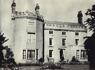
WThe Moor Hall is a 1905 house, built for Colonel Edward Ansell of Ansells Brewery, in Sutton Coldfield, Birmingham, England. It has been used as a hotel since 1930 and subsequently extended. It is on the site of a former 15th century building. It is also a suburb of the town, situated between the district of Roughley and Sutton town centre.
 W
WNew Hall Manor is a medieval manor house, now used as a hotel, in Sutton Coldfield, West Midlands, England.
 W
WThe New Hall Estate is the older of the two major private housing estates named after New Hall Manor in the Royal Town of Sutton Coldfield in the West Midlands in England. The newer being New Hall Manor Estate.
 W
WThe New Hall Manor Estate is the younger of the two major housing estates named after New Hall Manor in Walmley, West Midlands. The other estate is the New Hall Estate. It was built around 2000 and half was built by one company and the other half by another. This caused one half to be called "The Grange" by locals however this is an unofficial name. It was officially named The Avenue. This half is considered the most affluent part of the estate. The houses are larger than the others and house prices can reach £750,000.
 W
WNew Hall Valley Country Park is a country park located in New Hall Valley between Walmley, Wylde Green and Pype Hayes in the Sutton Coldfield area of north Birmingham. It is the first new country park in the UK for over a decade. The park is split into "phases".
 W
WNew Oscott is an area of Birmingham, England.
Paget Rangers F.C. is an English football club based in Sutton Coldfield, Birmingham, currently playing in the Midland League Division One.
 W
WPeddimore Hall is a manor house in the Walmley area of Sutton Coldfield in Birmingham, West Midlands, England. It is a Scheduled Ancient Monument and a Grade II listed building. It is now in use as a private residence.
 W
WPenns Hall is a building on Penns Lane, Walmley, Sutton Coldfield, Birmingham, England, operated as a hotel and country club by Ramada International. It is a Grade B locally listed building, and is licensed as a venue for civil marriages and civil partnerships.
Plantsbrook School,, is a secondary school with academy status located in Sutton Coldfield, Birmingham, England. The school has continued to consistently receive an "Outstanding" status with every Ofsted inspection, except the most recent one, in which it was rated as Good and the preceding one in which it was rated as REQUIRES IMPROVEMENT. The school was a Technology College and a Music College before the Specialist Schools initiative was made defunct.
 W
WRoughley is an electoral ward within the Royal Town of Sutton Coldfield, and is the most northerly part of the administrative area covered by the Royal Sutton Coldfield Town Council and the City of Birmingham. Over half of Roughley Ward is attractive Green Belt countryside, including arable and dairy farms, historic field boundaries survive with mature hedgerows and woodlands. Several public footpaths provide access to the countryside and the one linking Hillwood Road and Dale Farm provides distant views of Lichfield Cathedral and on a clear day the Pennine Hills.
 W
WStreetly is an area in the county of West Midlands, England which lies around 7 miles (11 km) to the north of Birmingham City Centre. It is uniquely located within the borders of Birmingham, Lichfield and Walsall district authorities, and is part of the West Midlands conurbation. It is adjacent to Sutton Coldfield, New Oscott, Great Barr, Four Oaks, Little Aston and Aldridge.
 W
WSutton Coldfield is a constituency represented in the House of Commons of the UK Parliament since 2001 by Andrew Mitchell, a Conservative.
 W
WSutton Coldfield railway station is the main railway station for the town of Sutton Coldfield, Birmingham, West Midlands, England. It is situated on the Redditch-Birmingham New Street-Lichfield Cross-City Line 7 1⁄2 miles (12.1 km) north east of Birmingham New Street.
 W
WSutton Coldfield Town Football Club is an English association football club based in Sutton Coldfield. The club participates in the Northern Premier League Division One South East.
 W
WSutton Coldfield Town Hall is a former hotel and council building in Sutton Coldfield, Birmingham, England. The building is Grade A locally listed.
WThe Sutton Coldfield transmitting station is a broadcasting and telecommunications facility located in Sutton Coldfield, England. In terms of population covered, it is the third most important transmitter in the UK, after Crystal Palace in London and Winter Hill near Bolton.
WSutton Four Oaks is one of the 40 electoral wards in Birmingham, England.
WSutton New Hall is one of the 40 electoral wards in Birmingham, England and is named after New Hall, a medieval manor house.
 W
WSutton Park is a large urban park located in Sutton Coldfield, Birmingham, West Midlands, England. Most of the park is a National Nature Reserve; large parts are also a Scheduled Ancient Monument. Sutton Park is one of the largest urban parks in the United Kingdom. The park covers more than 2,400 acres (970 ha) according to one source, or 2,200 acres (900 ha) according to another. It consists of a mix of heathland, wetlands and marshes, seven lakes, extensive ancient woodlands, several restaurants, a private 18-hole golf course on its western edge and a municipal golf course to the south, a donkey sanctuary, children's playgrounds and a visitors' centre. There is no entrance charge to the Park, however there is a parking charge for cars on Saturdays and Sundays during the summer. A wide range of leisure activities are undertaken in the park including dog walking, pony trekking, bike riding and kite flying and there are areas to fly model aeroplanes and helicopters. Additionally, a railway line runs through the park.
WSutton Trinity is one of the 40 electoral wards in Birmingham, England. The ward is named after Holy Trinity Church, the town's parish church.
WSutton Vesey is one of the 40 electoral wards in Birmingham, England.
WTudor Hill is a suburb of Sutton Coldfield, in the county of West Midlands, England.
 W
WWalmley is a village in Sutton Coldfield, Birmingham, England. It is in south Sutton Coldfield, near to Erdington, Minworth, Wylde Green, Pype Hayes and south of Thimble End. It is approximately 6 miles (9.7 km) northeast of Birmingham City Centre. It is the main focus of the Sutton New Hall Birmingham City Council ward.
WWylde Green is a residential area within the town of Sutton Coldfield in Birmingham, England in the West Midlands. It was in the county of Warwickshire. The area is in the Sutton Vesey ward.
 W
WWylde Green railway station is a railway station serving northern Wylde Green and Boldmere in Sutton Coldfield, West Midlands, England. It is on the Redditch-Birmingham New Street-Lichfield Cross-City Line 6 1⁄2 miles (10.5 km) north east of Birmingham New Street, and is in Centro fare zone 4.