 W
WAarhus Botanical Gardens is a botanical garden in Aarhus, Denmark. It is located north of the Old Town open-air village museum and was founded in 1875. Nowadays it covers an area of 21.5 hectares, with 5 hectares for the Old Town.
 W
WAllesø is a village and northwestern suburb of Odense, Funen, Denmark.
 W
WThe Bay of Aarhus, or Aarhus Bay, is a Danish waterway by Aarhus in eastern Jutland.
 W
WThe Bay of Mecklenburg, also known as the Mecklenburg Bay or Mecklenburg Bight, is a long narrow basin making up the southwestern finger-like arm of the Baltic Sea, between the shores of Germany to the south and the Danish islands of Lolland, Falster, and Møn to the north, the shores of Jutland to the west, and joining the largest part of the Baltic to the east.
 W
WEast Denmark is a geographical term that refers to the part of Denmark east of Storebælt, including Zealand and Bornholm. From a linguistic and historical point of view the term refers to the area east of the Øresund. The former dialects in Skåneland are accordingly called East Danish (Østdansk).
WEjlstrup is a village, with a population of 1,337, situated west of Odense, in Funen, Denmark. It lies to the south of Korup and north of Ubberud.
 W
WFarum Lake is a lake in Northeastern Zealand, Denmark.
 W
WThe Fisher Bank is a sand bank in the North Sea, off the west coast of Denmark. It consists of Great Fisher Bank, and Little Fisher Bank. Some older charts refer to them as the "Great Fishing Bank" and the "Little Fishing Bank". As Fisher it gives its name to one of the sea areas in the British Shipping Forecast.
 W
WFlensburg Firth or Flensborg Fjord is the westernmost inlet of the Baltic Sea. It forms part of the border between Germany to the south and Denmark to the north. Its length is between 40 and 50 km, depending on where it is considered to begin. It has the largest area of all the fjords of East Jutland, which are a special type of inlets, different from geological fjords.
 W
WFrøbjerg Bavnehøj is 131 metres (430 ft) above sealevel and is the highest natural point on the island of Funen.
 W
WFuresø is a lake in Northeastern Zealand, Denmark and the deepest lake in Denmark. It defined Farum municipality's southeast border and is the site of Nicolai Eigtved's 18th century small pleasure pavilion for Privy Councillor Johan Sigismund Schulin on the Furesø Lake called Frederiksdal Pavilion.
 W
WFyns Hoved is a bight of northeastern Funen, Denmark, curving south to form the approach to Odense Fjord. It is the northernmost point of Hindsholm and is thus Funen's northernmost point, dividing the Kattegat and the Great Belt. The eastern side of the bight between Fyns Hoved and Skoven, 5.5 metres (18 ft) to the south, is irregular, with a beach and hills behind it, and to the south of the bight is a small, shallow bay, Korshavn Bay, with the Korshavn Light in the vicinity. The bay is a natural harbour used by many yachtsmen.
 W
WThe Gram Formation is a geological formation in Gram, Denmark. It preserves fossils dating from the Miocene period. The formation consists of three layers: the glauconite-rich, the Gram Clay, and the Gram sand. The sediments in the formation were deposited in an open marine depositional environment known as the Gram Sea.
 W
WGrønsund is a strait in Denmark separating the island Falster from the smaller islands of Møn and Bogø. Grønsund is also the name of a locality on the northeast coast of Falster from where the ferries to Møn used to operate. Frønsund Gerry House was built in 1731 and listed in the [[Listed buildings in Guldborgsund Municipality|Danish registry of protected buildings and places in 11950.
 W
WGudenå or Gudenåen, is Denmark's longest river and runs through the central parts of the Jutlandic peninsula. An anglicized version of the name often seen is 'The River Guden'.
 W
WHarrestrup Å is an approximately 20 km long stream through the western suburbs of Copenhagen, Denmark. It rises at Harrestrup Mose in Vestskoven woodland on the border between Albertslund and Ballerup and flows through Damhus Lake and several parks on its way to the Øresund at Kalvebod Beach in Valby Park.
 W
WHindsholm is a peninsula forming the north-eastern extremity of the Danish island of Funen. It is bound to the south by the Kerteminde Fjord but linked to the rest of the island in the south-west. It belongs to Kerteminde municipality.
 W
WHorsens Fjord is an East Jutland-type fjord in the east coast of the Danish peninsula of Jutland which stretches from the islands of Alrø and Hjarnø in the east to the town of Horsens on the mainland. It is some 20 kilometres (12 mi) long. The navigational channel to Horsens has a depth of 7 metres (23 ft).
 W
WKilen Lake is a lake in Jutland.
 W
WKøge Å is a 20.6 km long stream or small river which drains into the Bay of Køge in central Køge, on the east coast of Zealand, some 40 km south of Copenhagen, Denmark. The stream originates in the area south of the protected Regnemarks Mose boglands and is 10 metres wide at its mouth. A 22 km gravel road for cyclists and pedestrians follows the stream from the town of Køge to Humleore on onwards to Borup station.
 W
WKriegers Flak is a reef located in the Baltic Sea, north of Rügen, south of Skåne with its west most point about 15 km east of Møn. It is named after the Danish naval officer Christian Krieger, who in 1840 mapped the Baltic Sea. The Danish part of the reef has at its most shallow place a depth of 16 m.
 W
WRivers of Denmark.Gudenå Kongeåen Odense River Pøleå Varde Vidå Skjern Å Suså Esrum Å Køge Å Usserød Å Vejle River
 W
WMjølnerparken is a housing project located between Nørrebro and Bispebjerg S-train station in Nørrebro, Copenhagen. Approximately 2,500 people live in the area; 98% are either immigrant or born to immigrants, who represent 38 different nationalities, mostly Middle-Eastern and African. The majority of the inhabitants are under 18 years old, and the area is known because of press reports on its crime rates.
 W
WMøllehøj is the highest natural point in Denmark at 170.86 m (561 ft).
 W
WNorthern Jutland is a historical region in Denmark, defined as Jutland north of the Kongeå. As with other historical regions of Denmark, Northern Jutland had its own ting assembly in the Middle Ages, seated in Viborg.
 W
WThe Odense River is a river located on the island of Funen, in central Denmark. It is about 60 kilometres (37 mi) long and is named after the Funish capital, Odense, which it passes through. Boats can be rented by the river, offering a scenic ride to Fruens Bøge. Excursion boats offer rides to Carlslund, with jazz music some Saturdays during the Summer.
 W
WOnsbjerg is a village on the island of Samsø in Denmark. It is located in Samsø Municipality
 W
WRoskilde Fjord is the fjord north of Roskilde, Denmark. It is a long branch of the Isefjord.
 W
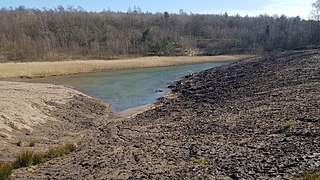
WStorå or Storåen is Denmark's second longest creek, spanning 104 kilometres (65 mi), and only surpassed by Gudenå. Storå originates southeast of Ikast, winding its way between Herning, Sunds, and Ørre. Then it winds through Nybro, Hodsager and Holstebro before ending up in Nissum Fjord.
WStorstrømmen is a strait in Denmark separating the island Falster from the island Zealand.
 W
WThe 83-kilometre (52 mi) long Suså River (Susåen), Zealand's largest waterway and longest river, runs into Lake Tystrup, the 8th largest lake in Denmark.
 W
WSvendborgsund is a strait that separates Funen from Tåsinge. In the west it flows into the South Funen Archipelago by the island Skarø, and in the east it ends in Thurø Sund and Skårupøre Sund, almost separated by Thurøbro, which is mostly a dam.
 W
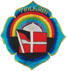
WThylejren aka "Frøstruplejren" started as an encampment and festival in the summer of 1970. The community behind the festival, Det Ny Samfund – had found an area in Han Herred between Frøstrup and Østerild where they could host a festival, inspired by the Isle of Wight festival in England and Woodstock in United States.
 W
WTranebjerg is a town, situated at the centre of the South Island of Samsø in Denmark. It is the largest town on Samsø and also the municipal seat of Samsø Municipality.
 W
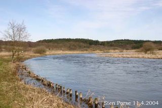
WUggerby Å - a river in northern Denmark.
 W
WAn urban district is the name used for urban or municipality districts in some of the larger municipalities of Denmark. The term is not strictly defined, but is usually bigger than a quarter or a city block.
 W
WUsserød Å, the principal drainage of Sjælsø Lake. is a stream in North Zealand to the north of Copenhagen, Denmark. It is approximately 9 kilometres long, drops 18 metres and is joined by Donse Å before itself flowing into Nive Å on its way to the Øresund at Nivå. It passes through the protected Usserød Ådal and the town of Hørsholm. Several watermills and early industrial sites are located along its course, the largest being Usserød Textile Mill.
 W
WVejle Fjord is an East Jutland-type fjord in Denmark. It is approximately 22 km (14 mi) in length, and it stretches east from the town of Vejle at its head to the towns of Trelde Næs on the south side and Juelsminde on the north side at the mouth. The fjord's generally calm surface waters are surrounded by low forested hills shaped by glaciers during the last ice age.
 W
WVestvolden is a rampart complex west of Copenhagen, Denmark. Stretching approximately 14 kilometres (9 mi) from Avedøre in the south to Utterslev Mose in the north, it is part of the last generation of land fortifications of the city. Built in the period 1888–1892 by up to 2,000 workers, it was the largest construction project of its time in Denmark. Vestvolden was divided into two fortifications end to end, the southern one named Vestenceinten and the northern, much shorter one named Husumenceinten; the name Vestvolden emerged as an informal collective term for the two. The building of this fortification system began during the so-called "Provisorietiden" 1885–1894. Under the Prime Minister who lacked a parliamentary majority but still refused to resign, J.B.S. Estrup. Instead this Prime Minister managed to enforce his annual Financial Laws, by bringing about King Christian IX's support for Provisional Financial Laws. This included support from the so-called Landstinget as well. The Landstinget was a smaller assembly of politicians, of which half of its members were chosen by the Monarch.
 W
WThe Wadden Sea National Parks in Denmark, Germany and the Netherlands are located along the German Bight of the North Sea. In Germany and Denmark they also mark the area of the UNESCO World Heritage Site of the Wadden Sea. Divided from each other by administrative borders, they form a single ecological entity. The purpose of the national parks is the protection of the Wadden Sea ecoregion.