 W
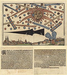
WThe 1561 celestial phenomenon over Nuremberg was a mass sighting of celestial phenomena or unidentified flying objects (UFO) above Nuremberg, Germany. The phenomenon has been interpreted by some modern UFO enthusiasts as an aerial battle of extraterrestrial origin. This view is mostly dismissed by skeptics, some referencing Carl Jung's mid-twentieth century writings about the subject while others find the phenomenon is likely to be a sun dog.
 W
WThe 1566 celestial phenomenon over Basel was a series of mass sightings of celestial phenomena above Basel, Switzerland. The Basel pamphlet of 1566 describes unusual sunrises and sunsets. Celestial phenomena were said to have "fought" together in the form of numerous red and black balls in the sky before the rising sun. The report is discussed among historians and meteorologists. The phenomenon has been interpreted by some ufologists to be a sky battle between unidentified flying objects. The leaflet written by historian Samuel Coccius reported it as a religious event. The Basel pamphlet of 1566 is not the only one of its kind. In the 15th and 16th centuries, many leaflets wrote of "miracles" and "sky spectacles".
 W
WIn meteorology, an air mass is a volume of air defined by its temperature and water vapor content. Air masses cover many hundreds or thousands of miles, and adapt to the characteristics of the surface below them. They are classified according to latitude and their continental or maritime source regions. Colder air masses are termed polar or arctic, while warmer air masses are deemed tropical. Continental and superior air masses are dry while maritime and monsoon air masses are moist.. Weather fronts separate air masses with different density characteristics. Once an air mass moves away from its source region, underlying vegetation and water bodies can quickly modify its character. Classification schemes tackle an air mass' characteristics, as well as modification.
 W
WAn anticyclone is a weather phenomenon defined as a large-scale circulation of winds around a central region of high atmospheric pressure, clockwise in the Northern Hemisphere and counterclockwise in the Southern Hemisphere. Effects of surface-based anticyclones include clearing skies as well as cooler, drier air. Fog can also form overnight within a region of higher pressure. Mid-tropospheric systems, such as the subtropical ridge, deflect tropical cyclones around their periphery and cause a temperature inversion inhibiting free convection near their center, building up surface-based haze under their base. Anticyclones aloft can form within warm core lows such as tropical cyclones, due to descending cool air from the backside of upper troughs such as polar highs, or from large scale sinking such as the subtropical ridge. The evolution of an anticyclone depends upon variables such as its size, intensity, and extent of moist convection, as well as the Coriolis force.
 W
WA cold wave is a weather phenomenon that is distinguished by a cooling of the air. Specifically, as used by the U.S. National Weather Service, a cold wave is a rapid fall in temperature within a 24-hour period requiring substantially increased protection to agriculture, industry, commerce, and social activities. The precise criterion for a cold wave is determined by the rate at which the temperature falls, and the minimum to which it falls. This minimum temperature is dependent on the geographical region and time of year.
 W
WA cold-core low, also known as an upper level low or cold-core cyclone, is a cyclone aloft which has an associated cold pool of air residing at high altitude within the Earth's troposphere, without a frontal structure. It is a low pressure system that strengthens with height in accordance with the thermal wind relationship. If a weak surface circulation forms in response to such a feature at subtropical latitudes of the eastern north Pacific or north Indian oceans, it is called a subtropical cyclone. Cloud cover and rainfall mainly occurs with these systems during the day. Severe weather, such as tornadoes, can occur near the center of cold-core lows. Cold lows can help spawn cyclones with significant weather impacts, such as polar lows, and Kármán vortices. Cold lows can lead directly to the development of tropical cyclones, owing to their associated cold pool of air aloft or by acting as additional outflow channels to aid in further development.
 W
WIn aerodynamics, the Crow instability, or V.C.I. vortex crow instability, is an inviscid line-vortex instability, named after its discoverer S. C. Crow. The Crow instability is most commonly observed in the skies behind large aircraft such as the Boeing 747. It occurs when the wingtip vortices interact with contrails from the engines, producing visible distortions in the shape of the contrail.
 W
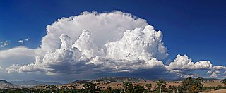
WIn meteorology, a cyclone (/ˈsaɪ.kloʊn/) is a large scale air mass that rotates around a strong center of low atmospheric pressure. Cyclones are characterized by inward spiraling winds that rotate about a zone of low pressure. The largest low-pressure systems are polar vortices and extratropical cyclones of the largest scale. Warm-core cyclones such as tropical cyclones and subtropical cyclones also lie within the synoptic scale. Mesocyclones, tornadoes, and dust devils lie within smaller mesoscale. Upper level cyclones can exist without the presence of a surface low, and can pinch off from the base of the tropical upper tropospheric trough during the summer months in the Northern Hemisphere. Cyclones have also been seen on extraterrestrial planets, such as Mars, Jupiter, and Neptune. Cyclogenesis is the process of cyclone formation and intensification. Extratropical cyclones begin as waves in large regions of enhanced mid-latitude temperature contrasts called baroclinic zones. These zones contract and form weather fronts as the cyclonic circulation closes and intensifies. Later in their life cycle, extratropical cyclones occlude as cold air masses undercut the warmer air and become cold core systems. A cyclone's track is guided over the course of its 2 to 6 day life cycle by the steering flow of the subtropical jet stream.
 W
WIn meteorology, diurnal temperature variation is the variation between a high temperature and a low temperature that occurs during the same day.
 W
WDownwelling is the process of accumulation and sinking of higher density material beneath lower density material, such as cold or saline water beneath warmer or fresher water or cold air beneath warm air. It is the sinking limb of a convection cell. Upwelling is the opposite process and together these two forces are responsible in the oceans for the thermohaline circulation. The sinking of cold lithosphere at subduction zones is another example of downwelling in plate tectonics.
 W
WA drought is an event of prolonged shortages in the water supply, whether atmospheric, surface water or ground water. A drought can last for months or years, or may be declared after as few as 15 days. It can have a substantial impact on the ecosystem and agriculture of the affected region and harm to the local economy. Annual dry seasons in the tropics significantly increase the chances of a drought developing and subsequent bush fires. Periods of heat can significantly worsen drought conditions by hastening evaporation of water vapour.
 W
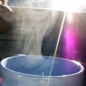
WEvaporation is a type of vaporization that occurs on the surface of a liquid as it changes into the gas phase. The surrounding gas must not be saturated with the evaporating substance. When the molecules of the liquid collide, they transfer energy to each other based on how they collide with each other. When a molecule near the surface absorbs enough energy to overcome the vapor pressure, it will escape and enter the surrounding air as a gas. When evaporation occurs, the energy removed from the vaporized liquid will reduce the temperature of the liquid, resulting in evaporative cooling.
 W
WEvapotranspiration (ET) is the sum of evaporation and plant transpiration from the Earth's land and ocean surface to the atmosphere. Evaporation accounts for the movement of water to the air from sources such as the soil, canopy interception, and water bodies. Transpiration accounts for the movement of water within a plant and the subsequent loss of water as vapor through stomata in its leaves in vascular plants and phyllids in non-vascular plants. Evapotranspiration is an important part of the water cycle. An element that contributes to evapotranspiration can be called an evapotranspirator.
 W
WA flood is an overflow of water that submerges land that is usually dry. In the sense of "flowing water", the word may also be applied to the inflow of the tide. Floods are an area of study of the discipline hydrology and are of significant concern in agriculture, civil engineering and public health. Human changes to the environment often increase the intensity and frequency of flooding, for example land use changes such as deforestation and removal of wetlands, changes in waterway course such as with levees, and larger environmental issues such as climate change and sea level rise.
 W
WThe freezing level, or 0 °C (zero-degree) isotherm, represents the altitude in which the temperature is at 0 °C in a free atmosphere. Any given measure is valid for only a short period of time, often less than a day.
WA heat wave, or heatwave, is a period of excessively hot weather, which may be accompanied by high humidity, especially in oceanic climate countries. While definitions vary, a heat wave is usually measured relative to the usual weather in the area and relative to normal temperatures for the season. Temperatures that people from a hotter climate consider normal can be called a heat wave in a cooler area if they are outside the normal climate pattern for that area.
 W
WA high-pressure area, high, or anticyclone, is a region where the atmospheric pressure at the surface of the planet is greater than its surrounding environment.
 W
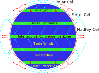
WHorse latitudes, subtropical ridges or subtropical highs are the subtropical latitudes between 30 and 35 degrees both north and south where Earth's atmosphere is dominated by the subtropical high, an area of high pressure, which suppresses precipitation and cloud formation, and has variable winds mixed with calm winds.
 W
WInflow is the flow of a fluid into a large collection of that fluid. Within meteorology, inflow normally refers to the influx of warmth and moisture from air within the Earth's atmosphere into storm systems. Extratropical cyclones are fed by inflow focused along their cold front and warm fronts. Tropical cyclones require a large inflow of warmth and moisture from warm oceans in order to develop significantly, mainly within the lowest 1 kilometre (0.62 mi) of the atmosphere. Once the flow of warm and moist air is cut off from thunderstorms and their associated tornadoes, normally by the thunderstorm's own rain-cooled outflow boundary, the storms begin to dissipate. Rear inflow jets behind squall lines act to erode the broad rain shield behind the squall line, and accelerate its forward motion.
 W
WA low-pressure area, low area or low is a region where the air pressure is lower than that of surrounding locations. Low-pressure systems form under areas of wind divergence that occur in the upper levels of the atmosphere. The formation process of a low-pressure area is known as cyclogenesis. Within the field of meteorology, atmospheric divergence aloft occurs in two areas. The first area is on the east side of upper troughs, which form half of a Rossby wave within the Westerlies. A second area of wind divergence aloft occurs ahead of embedded shortwave troughs, which are of smaller wavelength. Diverging winds aloft ahead of these troughs cause atmospheric lift within the troposphere below, which lowers surface pressures as upward motion partially counteracts the force of gravity.
 W
WThe meiyu front, also known as baiu front, is a persistent nearly stationary weak baroclinic zone in the lower troposphere. It is located over the east coast of China and Taiwan at its western end, and over the Pacific Ocean south of Japan at its eastern end.
 W
WOutflow, in meteorology, is air that flows outwards from a storm system. It is associated with ridging, or anticyclonic flow. In the low levels of the troposphere, outflow radiates from thunderstorms in the form of a wedge of rain-cooled air, which is visible as a thin rope-like cloud on weather satellite imagery or a fine line on weather radar imagery. For observers on the ground, a thunderstorm outflow boundary often approaches in otherwise clear skies as a low, thick cloud that brings with it a gust front.
 W
WA post-tropical cyclone is a former tropical cyclone. The word may refer to a former tropical cyclone undergoing extratropical transition or a tropical cyclone degenerating into a trough.
 W
WPotential evaporation (PE) or potential evapotranspiration (PET) is defined as the amount of evaporation that would occur if a sufficient water source were available. If the actual evapotranspiration is considered the net result of atmospheric demand for moisture from a surface and the ability of the surface to supply moisture, then PET is a measure of the demand side. Surface and air temperatures, insolation, and wind all affect this. A dryland is a place where annual potential evaporation exceeds annual precipitation.
 W
WIn meteorology, precipitation is any product of the condensation of atmospheric water vapor that falls under gravity from clouds. The main forms of precipitation include drizzle, rain, sleet, snow, ice pellets, graupel and hail. Precipitation occurs when a portion of the atmosphere becomes saturated with water vapor, so that the water condenses and "precipitates" or falls. Thus, fog and mist are not precipitation but colloids, because the water vapor does not condense sufficiently to precipitate. Two processes, possibly acting together, can lead to air becoming saturated: cooling the air or adding water vapor to the air. Precipitation forms as smaller droplets coalesce via collision with other rain drops or ice crystals within a cloud. Short, intense periods of rain in scattered locations are called "showers."
 W
WA pressure system is a relative peak or lull in the sea level pressure distribution. The surface pressure at sea level varies minimally, with the lowest value measured 87 kilopascals (26 inHg) and the highest recorded 108.57 kilopascals (32.06 inHg). High- and low-pressure systems evolve due to interactions of temperature differentials in the atmosphere, temperature differences between the atmosphere and water within oceans and lakes, the influence of upper-level disturbances, as well as the amount of solar heating or radiationized cooling an area receives. Pressure systems cause weather to be experienced locally. Low-pressure systems are associated with clouds and precipitation that minimize temperature changes throughout the day, whereas high-pressure systems normally associate with dry weather and mostly clear skies with larger diurnal temperature changes due to greater radiation at night and greater sunshine during the day. Pressure systems are analyzed by those in the field of meteorology within surface weather maps.
 W
WThe Saharan Air Layer (SAL) is an extremely hot, dry and sometimes dust-laden layer of the atmosphere that often overlies the cooler, more-humid surface air of the Atlantic Ocean. It carries upwards of 60 million tonnes of dust annually over the ocean and the Americas. This annual phenomena sometimes cools the ocean and suppresses Atlantic hurricane creation.
 W
WIn oceanography, sea state is the general condition of the free surface on a large body of water—with respect to wind waves and swell—at a certain location and moment. A sea state is characterized by statistics, including the wave height, period, and power spectrum. The sea state varies with time, as the wind conditions or swell conditions change. The sea state can either be assessed by an experienced observer, like a trained mariner, or through instruments like weather buoys, wave radar or remote sensing satellites.
 W
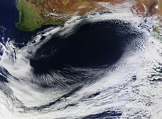
WSea surface temperature (SST) is the water temperature close to the ocean's surface. The exact meaning of surface varies according to the measurement method used, but it is between 1 millimetre (0.04 in) and 20 metres (70 ft) below the sea surface. Air masses in the Earth's atmosphere are highly modified by sea surface temperatures within a short distance of the shore. Localized areas of heavy snow can form in bands downwind of warm water bodies within an otherwise cold air mass. Warm sea surface temperatures are known to be a cause of tropical cyclogenesis over the Earth's oceans. Tropical cyclones can also cause a cool wake, due to turbulent mixing of the upper 30 metres (100 ft) of the ocean. SST changes diurnally, like the air above it, but to a lesser degree. There is less SST variation on breezy days than on calm days. In addition, ocean currents such as the Atlantic Multidecadal Oscillation (AMO), can effect SST's on multi-decadal time scales, a major impact results from the global thermohaline circulation, which affects average SST significantly throughout most of the world's oceans.
 W
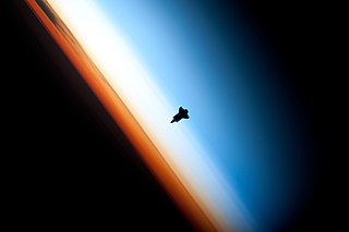
WThe sky is everything that lies above the surface of the Earth, including the atmosphere and outer space.
 W
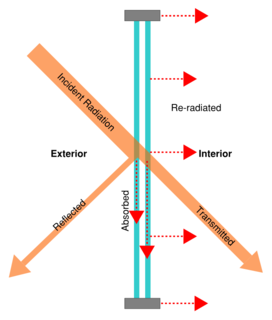
WSolar gain is the increase in thermal energy of a space, object or structure as it absorbs incident solar radiation. The amount of solar gain a space experiences is a function of the total incident solar irradiance and of the ability of any intervening material to transmit or resist the radiation.
 W
WThe stratosphere is the second major layer of Earth's atmosphere, just above the troposphere, and below the mesosphere. The stratosphere is stratified (layered) in temperature, with warmer layers higher and cooler layers closer to the Earth; this increase of temperature with altitude is a result of the absorption of the Sun's ultraviolet radiation by the ozone layer. This is in contrast to the troposphere, near the Earth's surface, where temperature decreases with altitude. The border between the troposphere and stratosphere, the tropopause, marks where this temperature inversion begins. Near the equator, the lower edge of the stratosphere is as high as 20 km, at midlatitudes around 10 km, and at the poles about 7 km Temperatures range from an average of −51 °C near the tropopause to an average of −15 °C near the mesosphere. Stratospheric temperatures also vary within the stratosphere as the seasons change, reaching particularly low temperatures in the polar night (winter). Winds in the stratosphere can far exceed those in the troposphere, reaching near 60 m/s in the Southern polar vortex.
 W
WIn the Earth's atmosphere, subsidence is the downward movement of an air parcel as it cools and becomes denser. By contrast, warm air becomes less dense and moves upwards.
 W
WThunder is the sound caused by lightning. Depending on the distance from and nature of the lightning, it can range from a sharp, loud crack to a long, low rumble (brontide). The sudden increase in pressure and temperature from lightning produces rapid expansion of the air within and surrounding the path of a lightning strike. In turn, this expansion of air creates a sonic shock wave, often referred to as a "thunderclap" or "peal of thunder". The study of thunder is known as brontology.
 W
WA tropical cyclone is a rapidly rotating storm system characterized by a low-pressure center, a closed low-level atmospheric circulation, strong winds, and a spiral arrangement of thunderstorms that produce heavy rain or squalls. Depending on its location and strength, a tropical cyclone is referred to by different names, including hurricane, typhoon, tropical storm, cyclonic storm, tropical depression, and simply cyclone. A hurricane is a tropical cyclone that occurs in the Atlantic Ocean and northeastern Pacific Ocean, and a typhoon occurs in the northwestern Pacific Ocean; in the south Pacific or Indian Ocean, comparable storms are referred to simply as "tropical cyclones" or "severe cyclonic storms".
 W
WA weather front is a boundary separating air masses of different characteristics such as air density, wind, and humidity. Disturbed weather often arises from these differences. For instance, cold fronts can bring bands of thunderstorms or be preceded by squall lines, while warm fronts are usually preceded by stratiform precipitation and fog. In summer, subtler humidity gradients known as or dry lines can trigger severe weather. Some fronts produce no precipitation and little cloudiness, although there is invariably a wind shift.
 W
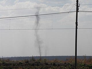
WA whirlwind is a weather phenomenon in which a vortex of wind forms due to instabilities and turbulence created by heating and flow (current) gradients. Whirlwinds occur all over the world and in any season.
 W
WA white squall is a sudden and violent windstorm at sea which is not accompanied by the black clouds generally characteristic of a squall. It manifests as a sudden increase in wind velocity in tropical and sub-tropical waters, and may be a microburst. The name refers to the white-capped waves and broken water, its meager warning to any unlucky seaman caught in its path. A white squall was allegedly behind the sinking of the brigantine Albatross on May 2, 1961 although,in fact, there were a number of traditional line squalls all around and a microburst was very unlikely. White squalls are rare at sea, but common on the Great Lakes of North America.
 W
WWind is the flow of gases on a large scale. On the surface of the Earth, wind consists of the bulk movement of air. In outer space, solar wind is the movement of gases or charged particles from the Sun through space, while planetary wind is the outgassing of light chemical elements from a planet's atmosphere into space. Winds are commonly classified by their spatial scale, their speed, the types of forces that cause them, the regions in which they occur, and their effect. The strongest observed winds on a planet in the Solar System occur on Neptune and Saturn. Winds have various aspects: velocity ; the density of the gas involved; energy content or wind energy. The wind is also an important means of transportation for seeds and small birds; with time things can travel thousands of miles in the wind.
WWind direction is reported by the direction from which it originates. For example, a north or northerly wind blows from the north to the south. Wind direction is usually reported in cardinal direction, or in degrees. Consequently, a wind blowing from the north has a wind direction referred to as 0° (360°); a wind blowing from the east has a wind direction referred to as 90°, etc.