 W
WA National Scenic Byway is a road recognized by the United States Department of Transportation for one or more of six "intrinsic qualities": archeological, cultural, historic, natural, recreational, and scenic. The program was established by Congress in 1991 to preserve and protect the nation's scenic but often less-traveled roads and promote tourism and economic development. The National Scenic Byways Program (NSBP) is administered by the Federal Highway Administration (FHWA).
 W
WState Route 28 (SR 28) is a 16.3-mile (26.2 km) state highway in Douglas County, Carson City, and Washoe County in western Nevada, United States, that runs along the northeastern shore of Lake Tahoe. SR 28 connects U.S. Route 50 (US 50) in Douglas County with California State Route 28 at Crystal Bay. SR 28 has been part of the Nevada scenic byway system since June 1994 and the National Scenic Byway system since September 1996.
 W
WHighway 88 is a designation for five state highways in Arkansas. All routes are maintained by the Arkansas Department of Transportation (ArDOT).
 W
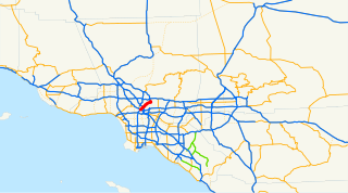
WThe Arroyo Seco Parkway, also known as the Pasadena Freeway, is the first freeway built in the United States. It connects Los Angeles with Pasadena alongside the Arroyo Seco seasonal river. It is notable not only for being the first, mostly opened in 1940, but for representing the transitional phase between early parkways and modern freeways. It conformed to modern standards when it was built, but is now regarded as a narrow, outdated roadway. A 1953 extension brought the south end to the Four Level Interchange in downtown Los Angeles and a connection with the rest of the freeway system.
 W
WSouth Carolina Highway 61 (SC 61) is a 67-mile-long (108 km) state highway in the U.S. state of South Carolina. The highway is designated on a north–south direction, but physically travels in an east–west direction, from SC 30 in Charleston to U.S. Route 78 (US 78) near Branchville. The portion of SC 61 from Church Creek Bridge and 10 miles (16 km) north is designated a National Scenic Byway.
 W
WThe Camino Real de Tierra Adentro was an historic 2,560-kilometre-long (1,590 mi) trade route between Mexico City and San Juan Pueblo, New Mexico, USA, from 1598 to 1882. It was the northernmost of the four major "royal roads" that linked Mexico City to its major tributaries during and after the Spanish colonial era.
 W
WThe Cascades Lakes Scenic Byway is a National Scenic Byway in central Oregon in the United States. It runs for 66 miles (106 km) in the rugged country of Deschutes and Klamath counties on the east side of the Cascade Range. It offers particularly good views of Mount Bachelor and provides access to many recreational facilities in central Oregon. The route is so named because it weaves past a number of small natural lakes along the Cascades, as well as several reservoirs on the upper Deschutes River.
 W
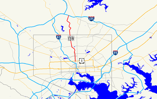
WCharles Street, known for most of its route as Maryland Route 139, runs through Baltimore City and through the Towson area of Baltimore County. On the north end it terminates at an intersection with Bellona Avenue near Interstate 695 (I-695) and at the south end it terminates in Federal Hill in Baltimore. Charles Street is one of the major routes through the city of Baltimore, and is a major public transportation corridor. For the one-way portions of Charles Street, the street is functionally complemented by the parallel St. Paul Street, Maryland Avenue, Cathedral Street, and Liberty Street.
 W
WSouth Carolina Highway 11 (SC 11), also known as the Cherokee Foothills Scenic Highway, is a 119.850-mile (192.880 km) state highway through the far northern part of the U.S. state of South Carolina, following the southernmost peaks of the Blue Ridge Mountains. The route is surrounded by peach orchards, quaint villages, and parks. It is an alternative to Interstate 85 (I-85) and has been featured by such publications as National Geographic, Rand McNally, and Southern Living.
 W
WColonial Parkway is a 23-mile (37 km) scenic parkway linking the three points of Virginia's Historic Triangle, Jamestown, Williamsburg, and Yorktown. It is part of the National Park Service's Colonial National Historical Park. Virginia's official state classification for the parkway is State Route 90003. With portions built between 1930 and 1957, it links the three communities via a roadway shielded from views of commercial development. The roadway is toll-free, is free of semi trucks, and has speed limits of around 35 to 45 mph. As a National Scenic Byway and All-American Road, it is also popular with tourists due to the James River and York River ends of the parkway. A video drive-thru is available.
 W
WRoute 169 is a 47.36-mile-long (76.22 km) state highway in the U.S. states of Connecticut and Massachusetts. It begins in the city of Norwich, Connecticut, and runs 38 miles (61 km) through Northeastern Connecticut, continuing across the state line into Southbridge, Massachusetts. The route ends in Charlton after another nine miles (14 km). A portion of the route in the town center of Pomfret is on the National Register of Historic Places as Pomfret Street Historic District, and 32.10 miles (51.66 km) of the road is designated as the Connecticut State Route 169 National Scenic Byway.
 W
WU.S. Route 23 or U.S. Highway 23 is a north–south U.S. Highway between Jacksonville, Florida, and Mackinaw City, Michigan. It is an original 1926 route which originally reached only as far south as Portsmouth, Ohio, and has since been extended. It was formerly part of the major highway known as the Dixie Highway. The highway's southern terminus is in Jacksonville, Florida at US 1/US 17. The northern terminus is at I-75 in Mackinaw City, Michigan.
 W
WCrowley's Ridge Parkway is a 212.0-mile-long (341.2 km) National Scenic Byway in northeast Arkansas and the Missouri Bootheel along Crowley's Ridge in the United States. Motorists can access the parkway from US Route 49 (US 49) at its southern terminus near the Helena Bridge over the Mississippi River outside Helena-West Helena, Arkansas, or from Missouri Route 25 (Route 25) near Kennett, Missouri. The parkway runs along Crowley's Ridge, a unique geological formation, and also parts of the St. Francis National Forest, the Mississippi River and the Mississippi Alluvial Plain. Along the route are many National Register of Historic Places properties, Civil War battlefields, parks, and other archeological and culturally significant points.
 W
WState Route 190 is a state highway in the U.S. state of California that is split into two parts by the Sierra Nevada. The western portion begins at Tipton at a junction with State Route 99 and heads east towards Porterville before ending at Quaking Aspen in the Sequoia National Forest. The eastern portion begins at US 395 at Olancha, heads east through Death Valley National Park, and ends at State Route 127 at Death Valley Junction. The 43.0-mile (69.2 km) portion over the Sierra Nevada remains unconstructed, and the California Department of Transportation (Caltrans) has no plans to build it through the wilderness areas. SR 190 is a National Scenic Byway known as the Death Valley Scenic Byway.
 W
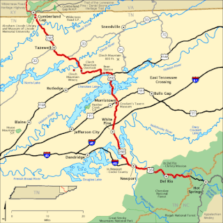
WThe East Tennessee Crossing Byway is a 83-mile (134 km) National Scenic Byway in the U.S. state of Tennessee. Established in 2009, it is one of the newest byways in the National Scenic Byway system. The scenic byway traverses mostly along an unsigned concurrency of U.S. Route 25E/State Route 32 (US 25E/SR 32) in East Tennessee.
 W
WState Route 4 is a state highway in the U.S. state of California, routed from Interstate 80 in the San Francisco Bay Area to State Route 89 in the Sierra Nevada. It roughly parallels the Sacramento-San Joaquin River Delta, a popular area for boating and fishing, with a number of accesses to marinas and other attractions. After crossing the Central Valley, the highway ascends up the Sierra foothills. It passes through Ebbetts Pass and contains the Ebbetts Pass Scenic Byway, a National Scenic Byway.
 W
WThe Grand Rounds National Scenic Byway is a linked series of park areas in Minneapolis, Minnesota, United States, that takes a roughly circular path through the city. The Minneapolis Park and Recreation Board developed the system over many years. The corridors include roads for automobile traffic plus separate paths for pedestrians and bicycles, and extend slightly into neighboring cities. About 50 miles (80 km) of roadway and paths are in the system, and much of it was built in the 1930s as part of Civilian Conservation Corps projects.
 W
WThe Great River Road is a collection of state and local roads that follow the course of the Mississippi River through ten states of the United States. They are Minnesota, Wisconsin, Iowa, Illinois, Missouri, Kentucky, Tennessee, Arkansas, Mississippi and Louisiana. It formerly extended north into Canada, serving the provinces of Ontario and Manitoba.
 W
WNew Hampshire Route 112 is a 56.39-mile-long (90.75 km) east–west state highway in northern New Hampshire. The highway winds across the state, connecting Bath to Conway through the heart of the scenic and mountainous White Mountain National Forest.
WState Route 28 (SR 28) is a 16.3-mile (26.2 km) state highway in Douglas County, Carson City, and Washoe County in western Nevada, United States, that runs along the northeastern shore of Lake Tahoe. SR 28 connects U.S. Route 50 (US 50) in Douglas County with California State Route 28 at Crystal Bay. SR 28 has been part of the Nevada scenic byway system since June 1994 and the National Scenic Byway system since September 1996.
 W
WLogan Canyon is in the western United States in northeastern Utah, a canyon that cuts its way through the Bear River Mountains, a branch of the Wasatch Range. It is popular for both summer and winter activities, especially rock-climbing, hiking, camping, fishing, snowmobiling, and skiing, at the Beaver Mountain ski resort. The canyon rises to an elevation of approximately 7,800 feet (2,400 m) above sea level, after a vertical climb of about 2,900 feet (880 m). Just beyond the summit is a steep road leading into Bear Lake Valley and scenic overlooks that provide dramatic views of deep blue Bear Lake. The western terminus is at Logan in Cache County and the eastern terminus is at Garden City in Rich County.
 W
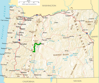
WThe McKenzie Pass–Santiam Pass Scenic Byway is an 82-mile-long (132 km) National Scenic Byway in the U.S. state of Oregon. The route is a loop designed to provide a tour of the high Cascade Range northwest of Bend, passing over both McKenzie Pass and Santiam Pass.
 W
WThe Meeting of the Great Rivers Scenic Route extends for 33.0 miles (53.1 km) in southwestern Illinois, travelling through the floodplain of the Mississippi and Illinois Rivers. The route has been officially designated as a National Scenic Byway by the Federal Highway Administration. The route coincides with a portion of the Great River Road.
 W
WThe Midland Trail is a National Scenic Byway which carries U.S. Route 60 (US 60) through a portion of the southern part of the U.S. state of West Virginia between Charleston and Sam Black Church. It was part of the longer transcontinental Midland Trail.
 W
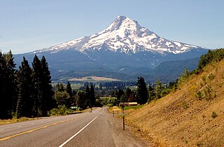
WThe Mount Hood Highway No. 26 is the Oregon Department of Transportation's designation for a 96.74-mile-long (155.69 km) highway from Portland east around the south side of Mount Hood and north via Bennett Pass to Hood River. It is marked as U.S. Route 26 from Portland to near Mount Hood and Oregon Route 35 the rest of the way to Hood River.
 W
WMount Nebo is the southernmost and highest mountain in the Wasatch Range of Utah, in the United States. Named after the biblical Mount Nebo overlooking Israel, which is said to be the place of Moses' death, it is the centerpiece of the Mount Nebo Wilderness, inside the Uinta National Forest.
 W
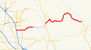
WThe Outback Scenic Byway is a designated National Scenic Byway on Oregon state highways that features the scenic rugged landscape of Central Oregon.
 W
WState Highway 55 (SH-55) is an Idaho highway from Marsing to New Meadows, connecting with US-95 at both ends.
 W
WU.S. Route 66 was a United States Numbered Highway in Illinois that connected St. Louis, Missouri, and Chicago, Illinois. The historic Route 66, the Mother Road or Main Street of America, took long distance automobile travelers from Chicago to Southern California. The highway had previously been Illinois Route 4 (IL 4) and the road has now been largely replaced with Interstate 55 (I-55). Parts of the road still carry traffic and six separate portions of the roadbed have been listed on the National Register of Historic Places.
 W
WThe historic U.S. Route 66 ran east–west across the central part of the state of New Mexico, along the path now taken by Interstate 40 (I-40). However, until 1937, it took a longer route via Los Lunas, Albuquerque, and Santa Fe, now roughly New Mexico State Road 6 (NM 6), I-25, and US 84. Large portions of the old road parallel to I-40 have been designated NM 117, NM 118, NM 122, NM 124, NM 333, three separate loops of I-40 Business, and state-maintained frontage roads.
WRoute 169 is a 47.36-mile-long (76.22 km) state highway in the U.S. states of Connecticut and Massachusetts. It begins in the city of Norwich, Connecticut, and runs 38 miles (61 km) through Northeastern Connecticut, continuing across the state line into Southbridge, Massachusetts. The route ends in Charlton after another nine miles (14 km). A portion of the route in the town center of Pomfret is on the National Register of Historic Places as Pomfret Street Historic District, and 32.10 miles (51.66 km) of the road is designated as the Connecticut State Route 169 National Scenic Byway.
 W
WThe Russell–Brasstown Scenic Byway is a National Scenic Byway in the U.S. state of Georgia that includes parts of Georgia State Route 17 (SR 17), SR 75, SR 180, and SR 75 Alternate, as well as the entire length of SR 348.
 W
WThe Great Lakes Seaway Trail, formerly named and commonly known as the Seaway Trail, is a 518-mile (834 km) National Scenic Byway in the northeastern United States, mostly contained in New York but with a small segment in Pennsylvania. The trail consists of a series of designated roads and highways that travel along the Saint Lawrence Seaway—specifically, Lake Erie, the Niagara River, Lake Ontario, and the Saint Lawrence River. It begins at the Ohio state line in rural Erie County, Pennsylvania, and travels through several cities and villages before ending at the Seaway International Bridge northeast of the village of Massena in St. Lawrence County, New York. It is maintained by the non-profit Seaway Trail, Inc.
 W
WSkyline Drive is a 105-mile (169 km) road that runs the entire length of the National Park Service's Shenandoah National Park in the Blue Ridge Mountains of Virginia, generally along the ridge of the mountains. The drive's northern terminus is at an intersection with U.S. Route 340 (US 340) near Front Royal, and the southern terminus is at an interchange with US 250 near Interstate 64 (I-64) in Rockfish Gap, where the road continues south as the Blue Ridge Parkway. The road has intermediate interchanges with US 211 in Thornton Gap and US 33 in Swift Run Gap. Skyline Drive is part of Virginia State Route 48, which also includes the Virginia portion of the Blue Ridge Parkway, but this designation is not signed.
WSouth Carolina Highway 61 (SC 61) is a 67-mile-long (108 km) state highway in the U.S. state of South Carolina. The highway is designated on a north–south direction, but physically travels in an east–west direction, from SC 30 in Charleston to U.S. Route 78 (US 78) near Branchville. The portion of SC 61 from Church Creek Bridge and 10 miles (16 km) north is designated a National Scenic Byway.
 W
WThe Talimena Scenic Drive is a National Scenic Byway in southeastern Oklahoma and extreme western Arkansas spanning a 54.0-mile (86.9 km) stretch of Oklahoma State Highway 1 (SH-1) and Arkansas Highway 88 (AR 88) from Talihina, Oklahoma, to Mena, Arkansas.
 W
WState Route 143 (SR-143) is a state highway in the U.S. state of Utah. The entire highway has been designated the Brian Head-Panguitch Lake Scenic Byway as part of the Utah Scenic Byways program. This road has also been designated as Utah's Patchwork Parkway as part of the National Forest Scenic Byway program.
 W
WThe West Cascades Scenic Byway is a 220-mile (350 km) National Scenic Byway in the U.S. state of Oregon. The route is designed to provide a tour on the west side of the Cascade Range along the east side of the Willamette Valley.
 W
WThe White Mountain Trail is a National Scenic Byway in the U.S. state of New Hampshire. It travels through the heart of the White Mountains crossing three major mountain passes. Despite the name it is a scenic byway accessible by car and not a hiking trail.
 W
WThe Wilderness Road was one of two principal routes used by colonial and early national era settlers to reach Kentucky from the East. Although this road goes through the Cumberland Gap into southern Kentucky and northern Tennessee, the other is sometimes called the "Cumberland Road" because it started in Fort Cumberland in Maryland. Despite Kentucky Senator Henry Clay's advocacy of this route, early in the 19th century, the northern route was selected for the National Road, connecting near Washington, Pennsylvania into the Ohio Valley of northern Kentucky and Ohio.