 W
WBhunya Airfield is a rural airstrip serving Bhunya, a forest products community in the Manzini Region of Eswatini. It is 8 kilometres (5 mi) southwest of the town.
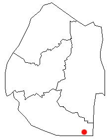
WBig Bend is a town in eastern Eswatini, lying on the Lusutfu River. Its main industry is farming and it is based mostly on sugar plantations. Big Bend is also surrounded by nature/game reserves such as Mhlosinga Nature Reserve and Nisela Safaris. Big Bend boasts some of the best sunsets and views in the country.
 W
WEmlembe is the highest mountain in Eswatini. It is located in the east uKhahlamba mountain range, on the border with South Africa. It is located in the South African province of Mpumalanga and the Swazi province of Hhohho.
 W
WHlatikulu is a town located in the Shiselweni district of southern Eswatini.
WHluti is a town in Eswatini, located in the Shiselweni Region. As of 2005, it has a population of 6,763.
WKubuta Airfield is a rural airstrip serving Kubuta, an Inkhundla in the Shiselweni Region of Eswatini.
 W
WLavumisa is a town located in the Shiselweni district of southern Eswatini.
 W
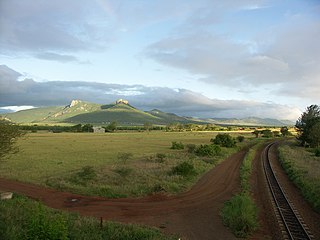
WThe Lebombo Mountains, also called Lubombo Mountains, are an 800 km-long (500 mi), narrow range of mountains in Southern Africa. They stretch from Hluhluwe in KwaZulu-Natal in the south to Punda Maria in the Limpopo Province in South Africa in the north. Parts of the mountain range are also found in Mozambique and Eswatini.
 W
WThis is a list of cities and towns in Eswatini. The table below also includes the population and region information.
 W
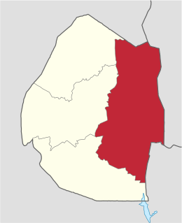
WLubombo is a region of Eswatini, located in the east of the country. It has an area of 5,849.11 km² and a population of 212,531 (2017). Its administrative center is Siteki. It borders all three other regions: Hhohho to the north, Manzini to the west, and Shiselweni to the south. It is divided into 11 tinkhundla.
WMalkerns is a town in Eswatini, located in the Manzini District. As of 2019, it has a population of 8,074.
WMankayane is a town located in the Manzini region of Eswatini. This small town services the chiefdom of Velezizweni. Nearby are the extensive man-made forests which cover much of the high veld areas of Eswatini. The area around Mankayane is also covered in small homesteads where traditional forms of agriculture are carried out. Other small irrigation schemes now exist providing a cash cropping basis for some local farmers. One such scheme is Ntamakuphila.
 W
WManzini is a region of Eswatini, located in the center-west of the country. It has an area of 4,093.59 km² and a population of 355,945 (2017). Its administrative center is Manzini. It borders all three other regions: Hhohho in the north, Lubombo in the east, and Shiselweni in the south. It is bordered by the Mpumalanga province in South Africa to the west.
 W
WThe Maputo River, also called Great Usutu River, Lusutfu River, or Suthu River, is a river in South Africa, Eswatini, and Mozambique. The name Suthu refers to Basotho people who lived near the source of the river, but were attacked and displaced by Swazis. It is also said to mean 'dark brown', a description of the river's muddy water.
 W
WMatsapha Airport is an airport located near Manzini, a city in Manzini District of Eswatini. It serves flights of the Eswatini Government and mercy flights.
 W
WThe Mbuluzi River is one of the main rivers of Eswatini, and an important river in Mozambique. On the boundary of these countries, the Mbuluzi cuts through the Lebombo Range, before entering the Mozambican plain. It empties into the Estuário do Espírito Santo and then Maputo Bay at Maputo, and its waters pass under the Maputo–Katembe bridge, completed in 2018.
WMhlume is a town located in the Lubombo district of Eswatini.
WMhlume Airfield is an airstrip serving Mhlume, an agricultural town in the Lubombo Region of Eswatini. The runway is on the northwest corner of the town.
 W
WThe Mlawula Nature Reserve is a nature reserve situated in north-eastern Eswatini. It covers approximately 16,500 hectares and is adjacent to Mbuluzi Game Reserve, Simunye Nature Reserve, and Hlane Royal National Park.
 W
WThe Moodies Group is a geological formation in South Africa and Eswatini. It has the oldest well-preserved siliciclastic tidal deposits on Earth, where microbial mats flourished.
 W
WThe Ngwavuma is a river in Eswatini and KwaZulu-Natal Province in southern Africa. It is also known as the Inguavuma, Ingwavuma, Ingwovuma, and Nggwavuma, and is one of the five major rivers in Eswatini. It arises in southwestern Eswatini and flows eastward. It is a tributary of the Pongola River.
 W
WNgwenya is a town in western Eswatini, lying near the border with South Africa, north west of Mbabane, on the MR3 road. The South African town opposite Ngwenya is Oshoek in Mpumalanga province.
WNhlangano is the fourth largest town in Eswatini. It is the capital of the southern district of Shiselweni. The town was formerly known as Goedgegun, but the name was changed to Nhlangano, meaning "the meeting place". Nhlangano is located beside the Ngwavuma River. King George VI of the United Kingdom met with King Sobhuza in the town in 1947 to thank him for the war effort during the Second World War.
WNhlangano Airfield is an airport serving Nhlangano, a town in the Shiselweni Region of Eswatini.
WNsoko Airfield is an airstrip serving Nsoko, an agricultural village in the Lubombo Region of Eswatini. The runway is within the Nisela Game Reserve, 4 kilometres (2.5 mi) northeast of Nsoko, and 5 kilometres (3.1 mi) west of the South African border.
WThe Onverwacht Group or Onverwacht Series is a series of greenstone belts and volcanic rock formations from the Archean Eon in the Kaapvaal Craton in South Africa and Eswatini.
 W
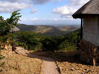
WThe Phophonyane Falls Nature Reserve is a scenic, 600 ha large nature reserve and tourist destination near Piggs Peak, Eswatini.
 W
WPiggs Peak is a town in northwestern Eswatini. It was founded around gold prospecting in 1884, but its main industry is now forestry. The Phophonyane Falls lie near the town. Piggs Peak Casino takes its name from the area.
WPiggs Peak Airfield is an airport serving Piggs Peak in the Hhohho Region of Eswatini. The airport is at Ngonini, an agricultural village 24 kilometres (15 mi) northeast of Piggs Peak.
 W
WEswatini is divided into four regions: Hhohho, Lubombo, Manzini, and Shiselweni. Each region is further divided into tinkhundla. There are 55 tinkhundla in Swaziland and each elects one representative to the House of Assembly of Eswatini. Tinkhundla are, in turn, divided into smaller imiphakatsi.ISO 3166-2:SZ Map Key
 W
WShiselweni is a region of Eswatini, located in the south of the country. It has an area of 3,786.71 km² and a population of 204,111 (2017). Its administrative center is Nhlangano. It borders Lubombo in the northeast and Manzini Region in the northwest.
 W
WSibebe is a granite mountain in Eswatini, located 10 km from the capital city Mbabane. It is the second-largest monolith in the world and the largest exposed granite pluton, rising 350m above the valley of the Mbuluzi River. It is also known as 'Bald Rock'.
WSimunye is a sugar mill town on the lowveld in eastern Eswatini. Almost all of the residents of the town work for the Royal Swaziland Sugar Corporation's sugar mill located nearby.
WSimunye Airfield is an airstrip serving Simunye, a town in the Lubombo Region of Eswatini.
WSiteki is a town in eastern Eswatini, lying west of the Lebombo Mountains. It is named for a declaration of Mbandzeni permitting his troops to marry.
WSiteki Airfield is an airstrip serving Siteki, a town in the Lubombo Region of Eswatini. The runway is 2 kilometres (1.2 mi) south of the town.
WTambankulu Airfield is an airstrip serving Tambankulu, in Eswatini.
WTambuti Airfield is an airstrip serving the sugar plantation region around Big Bend, a town in the Lubombo Region of Eswatini. The airport is 16 kilometres (9.9 mi) west-northwest of Big Bend.
WTshaneni Airfield is an airstrip serving Tshaneni, in Eswatini.
WUbombo Ranches Airfield is an airport serving the sugar refinery town of Big Bend in Lubombo Region, Eswatini. The runway is just west of the refinery.
 W
WIn Eswatini, an umphakatsi is an administrative subdivision smaller than an inkhundla; there are 360 imiphakatsi in the country, each approximately equivalent to a local community. In western societies it could be also equivalent to a township. Imiphakatsi are either Royal villages with a Royal kraal or chief residences which are administered under a Swazi chief or a Royal prince through Swazi Law and Custom. The official residence of the Ndlovukati at Ludzidzini is also designated an umphakatsi.