 W
WBilliatt Conservation Park, formerly the Billiatt National Park, is a protected area in the Australian state of South Australia located in the locality of Sandalwood about 200 kilometres (120 mi) east of the state capital of Adelaide.
 W
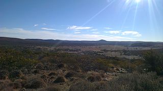
WThe Boolcoomatta, Bindarrah and Kalkaroo Stations Important Bird Area is a 1402 km2 tract of land in north-eastern South Australia. It comprises three pastoral properties, 53,000 ha Kalkaroo Station, 24,000 ha Bindarrah Station, and 63,000 ha Boolcoomatta. The whole site has been identified by BirdLife International as an Important Bird Area (IBA) because it supports a significant population of endangered plains-wanderers – perhaps the largest population of the species outside the Riverina region of New South Wales.
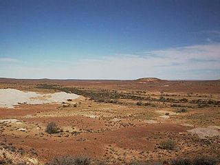
WBulgunnia Station is a 3,200 square kilometres (1,236 sq mi) sheep station in north-western South Australia.
 W
WCoffin Bay National Park is a protected area in on the Eyre Peninsula of South Australia, Australia, which is located about 301 km west of Adelaide and about 46 km west of Port Lincoln. The town of Coffin Bay is near the entrance to the national park. The national park occupies the Coffin Bay Peninsula - a long peninsula with a sheltered bay to its north, coastal dunes, swamps and a coastline which overlooks islands, reefs, limestone cliffs and white surf beaches.
 W
WThe Coongie Lakes is a freshwater wetland system located in the Far North region of South Australia. The 21,790-square-kilometre (8,410 sq mi) lakes system is located approximately 1,046 kilometres north of the Adelaide city centre. The wetlands includes lakes, channels, billabongs, shallow floodplains, deltas, and interdune swamps. It lies on the floodplain of Cooper Creek, an ephemeral river flowing through a desert landscape in the Lake Eyre Basin which rarely, after occasional large floods, empties into Lake Eyre. The wetland system has been recognised both as being of international importance by designation under the Ramsar Convention with a listing on 15 June 1987 and being nationally important within Australia with a listing in A Directory of Important Wetlands in Australia (DIWA). Its extent includes the regional town of Innamincka, the Malkumba-Coongie Lakes National Park, the Innamincka Regional Reserve, the Strzelecki Regional Reserve and the Coongie Lakes Important Bird Area.
 W
WThe Coorong National Park is a protected area located in South Australia about 156 kilometres (97 mi) southeast of Adelaide and that predominantly covers a lagoon ecosystem officially known as the Coorong and the Younghusband Peninsula on the Coorong's southern side.
 W
WThe Discovery Bay Coastal Park is a linear protected area of coastal land in western Victoria, south-eastern Australia. The 10,460-hectare (25,800-acre) park extends along the coast of Discovery Bay from Cape Nelson north-westwards for 50 kilometres (31 mi) to the border with South Australia. The park was listed on Australia's now-defunct Register of the National Estate, and lies within the traditional lands of the Gunditjmara people.
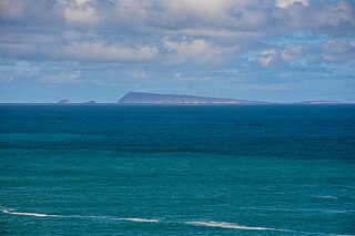
WFlinders Island is an island in the Investigator Group off the coast of South Australia approximately 32 kilometres (20 mi) west of mainland town Elliston. It was named by Matthew Flinders after his younger brother Samuel Flinders, the second lieutenant on HMS Investigator in 1802.
 W
WThe Ikara-Flinders Ranges National Park is situated approximately 400 km north of Adelaide in the northern central part of South Australia's largest mountain range, the Flinders Ranges. The park covers an area of 912 km², northeast of the small town of Hawker. The Heysen Trail and Mawson Trails pass through the park.
WArkaroola is the common name for the Arkaroola Wilderness Sanctuary, a wildlife sanctuary situated on 610 square kilometres of freehold and pastoral lease land in South Australia. It is located 700 kilometres north of the Adelaide city centre in the Northern Flinders Ranges, adjacent to the Vulkathunha-Gammon Ranges National Park and the Mawson Plateau. The most common way to get there is by car, but air travel can be chartered from Parafield Airport, Adelaide Airport or Aldinga Airfield. It was used as a location set for the 2002 film The Tracker.
 W
WGawler Ranges National Park is a 1,633 km2 (631 sq mi) protected area lying 350 km (217 mi) north-west of Adelaide in the northern Eyre Peninsula of South Australia. It is known for its spectacular rock formations.
WGoose Island Conservation Park is a protected area in the Australian state of South Australia, located on Goose Island and other islets in the vicinity of Wardang Island in Spencer Gulf. The constituent islands are located within 5 kilometres to 12 kilometres in the sector between west and north west of Port Victoria.
 W
WThe Goyder Lagoon is a large ephemeral swamp in the Australian state of South Australia in the state's Far North region. The lake is part of the Diamantina River floodplain, lying beside the Birdsville Track close to the state border with Queensland.
 W
WGranite Downs was a 9,000-square-kilometre (3,475 sq mi) cattle station in arid northern South Australia.
WThe Gulf St Vincent Important Bird Area comprises land extending along the coast of Gulf St Vincent, north of Adelaide, South Australia.
 W
WGum Lagoon Conservation Park is an 8765 ha protected area about 40 km south-west of Keith in the Limestone Coast region of South Australia. It lies about 20 km inland from the southern end of the Coorong. It contains an isolated block of mallee woodland important for malleefowl conservation.
WThe Investigator Group is an archipelago in South Australia that consists of Flinders Island and five island groups located off the western coast of the Eyre Peninsula. It is named after HMS Investigator by her commander, Matthew Flinders when he explored the area in 1802. The Group lies within the Great Australian Bight. All the islands except Flinders Island, and a part of Pearson Island, are within the Investigator Group Wilderness Protection Area and the Waldegrave Islands Conservation Park.
 W
WKangaroo Island, also known as Karta, is Australia's third-largest island, after Tasmania and Melville Island. It lies in the state of South Australia 112 km (70 mi) southwest of Adelaide. Its closest point to the mainland is Snapper Point in Backstairs Passage, which is 13.5 km (8.4 mi) from the Fleurieu Peninsula.
 W
WLake Eyre, officially known as Kati Thanda–Lake Eyre, is an endorheic lake in east-central Far North South Australia, some 700 km (435 mi) north of Adelaide. The shallow lake is the depocentre of the vast endorheic Lake Eyre basin, and contains the lowest natural point in Australia at approximately 15 m (49 ft) below sea level (AHD), and on the rare occasions that it fills completely, is the largest lake in Australia covering an area up to 9,500 km2 (3,668 sq mi). When the lake is full, it has the same salinity level as seawater, but becomes hypersaline as the lake dries up and the water evaporates.
WThe Lake Hawdon System Important Bird Area comprises an area of 374 square kilometres covering a series of five coastal lakes in the Limestone Coast of South Australia. They are the most important of a string of regional lakes occupying swale corridors between modern and historical sand dunes.
WLake Newland Conservation Park is a protected area in the Australian state of South Australia located on the west coast of the Eyre Peninsula about 10 kilometres (6.2 mi) north of the town of Elliston. It was proclaimed in 1991 in order to protect Lake Newland, a hypersaline lake, and an associated wetland complex. It lies in the traditional lands of the Wirangu people.
 W
WLake Torrens is a large ephemeral, normally endorheic salt lake in central South Australia. After sufficiently extreme rainfall events, the lake flows out through the Pirie-Torrens corridor to the Spencer Gulf.
 W
WLake Alexandrina is a coastal freshwater lake located between the Fleurieu and Kangaroo Island and Murray and Mallee regions of South Australia, about 100 kilometres (62 mi) south-east of Adelaide. The lake adjoins the smaller Lake Albert and a coastal lagoon called The Coorong to its southeast, before draining into the Great Australian Bight via a short, narrow opening known as Murray Mouth.
WMount Lyndhurst Important Bird Area comprises a 93 km2 part of Mount Lyndhurst Station, a pastoral lease lying on the north-west margin of the Flinders Ranges, about 30 km east of the town of Lyndhurst, South Australia. It is accessible via the Strzelecki Track.
WThe Nuyts Archipelago is an island group located in South Australia in the Great Australian Bight to the south of the town of Ceduna on the west coast of the Eyre Peninsula. It consisting of mostly granitic islands and reefs that provide breeding sites for Australian sea lions and support colonies of short-tailed shearwater. It also includes the island group known as the Isles of St Francis. All the islands with exception of a part of Evans Island, are located with the following protected areas - the Nuyts Archipelago Wilderness Protection Area and the Nuyts Archipelago Conservation Park.
 W
WPeebinga Conservation Park is a 34 km2 protected area lying 40 km north of the town of Pinnaroo in the Murray Mallee region of south-eastern South Australia, about 240 km east of Adelaide and 10 km west of the Victorian border.
WThe Riverland Mallee Important Bird Area comprises a 12,200 square kilometres tract of mallee habitat and riverine woodland extending from near Waikerie in the Riverland region in eastern South Australia north-eastwards into south-western New South Wales.
 W
WThe Seagull Lake is sub-coastal saline lake fed by a marine spring located near Sceale Bay on the western side of the Eyre Peninsula in South Australia. It lies about 20 kilometres (12 mi) south of Streaky Bay and 280 kilometres (170 mi) north of Port Lincoln.
WThe Seagull Lake is sub-coastal saline lake fed by a marine spring located near Sceale Bay on the western side of the Eyre Peninsula in South Australia. It lies about 20 kilometres (12 mi) south of Streaky Bay and 280 kilometres (170 mi) north of Port Lincoln.
 W
WThe Simpson Desert Important Bird Area comprises some 22,848 km2 of land within the Simpson Desert in south-western Queensland and north-eastern South Australia. It consists of five large contiguous reserves subject to little grazing pressure and good habitat management that are either known, or likely, to provide suitable habitat for Eyrean grasswrens.
 W
WThe Sir Joseph Banks Group is an archipelago in the Australian state of South Australia located in Spencer Gulf about 20 kilometres (12 mi) off the eastern coast of the Eyre Peninsula. It consists of 21 islands of which eighteen are in the Sir Joseph Banks Group Conservation Park while the surrounding waters are in the Sir Joseph Banks Group Marine Park. It is considered to be an important seabird breeding site.
WThe Southern Yorke Peninsula Important Bird Area is a 348 square kilometres tract of land consisting of most of the south-western tip of the Yorke Peninsula in South Australia about 300 kilometres west of Adelaide.
WThe Spencer Gulf Important Bird Area comprises a 460.38 square kilometres strip of coastal land extending for about 100 kilometres along the north-eastern coast of the Spencer Gulf in South Australia. It is considered to be an important site for waders, or shorebirds.
 W
WThe Strzelecki Desert Lakes Important Bird Area is an Important Bird Area (IBA) in the Australian state of South Australia which consists of a series of ephemeral waterbodies in the arid Strzelecki Desert in the state's Far North region. It is considered to be important for waterbirds when its constituent lakes hold water in the aftermath of floods.
WTourville and Murat Bays Important Bird Area is an important bird area in South Australia with a combined area of 117 square kilometres, located west to the town of Ceduna on the north-west corner of the Eyre Peninsula in the Great Australian Bight. It is considered to be an important area because of the resident populations of waders, or shorebirds.
 W
WTroubridge Island is an island located in the south west corner of Gulf St Vincent in South Australia near the eastern edge of the Troubridge Shoals off the east coast of Yorke Peninsula about 8 kilometres (5.0 mi) southeast by east of the town of Edithburgh It is notable for being a site of an operating lighthouse from 1856 until 2002 and as a site for a sea bird rookery. Since 1982, the island has been part of the Troubridge Island Conservation Park.
 W
WVenus Bay is a small tourist and fishing town sited on the bay of the same name, on the Eyre Peninsula in South Australia. The town population numbers in the twenties for most of the year, but its numbers greatly increase during the summer holidays. At the 2006 census, Venus Bay had a population of 139. The town also serves professional fishermen who fish the Southern Ocean.
WThe Watervalley Wetlands is a nationally important wetland system located in the Australian state of South Australia which consists of a series of contiguous wetlands, lying on 56.6 square kilometres (21.9 sq mi) of private land between the Coorong National Park and Gum Lagoon Conservation Park, in the state's south-east.
 W
WWedge Island is an island in the Australian state of South Australia located within the island group known as the Gambier Islands near the entrance to Spencer Gulf. It is the largest of the Gambier Islands, covers an area of about 10 square kilometres (3.9 sq mi) and is partly privately owned.
WWedge Island is an island in the Australian state of South Australia located within the island group known as the Gambier Islands near the entrance to Spencer Gulf. It is the largest of the Gambier Islands, covers an area of about 10 square kilometres (3.9 sq mi) and is partly privately owned.
WThe Wyperfeld, Big Desert and Ngarkat Important Bird Area comprises a 9743 km2 tract of semiarid mallee woodlands and shrublands in south-eastern Australia, straddling the border between the states of South Australia and Victoria.