 W
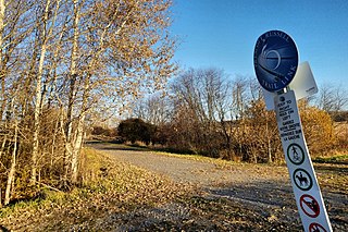
WRoute 4 is a 63 km (39 mi) long, two-lane uncontrolled access secondary highway in eastern Prince Edward Island, Canada. In runs east from the Trans-Canada Highway (Route 1) at Wood Islands along the Northumberland Straight to Route 18 the settlement of High Bank, where it turns north and passes through Murray River and Montague before ending at Route 2 at Dingwells Mills. Its maximum speed limit is 90 km/h (56 mph).
 W
WPrince Edward Island Route 5 is a highway in eastern Prince Edward Island.
 W
WPrince Edward Island Route 6 is a secondary highway in central Prince Edward Island.
 W
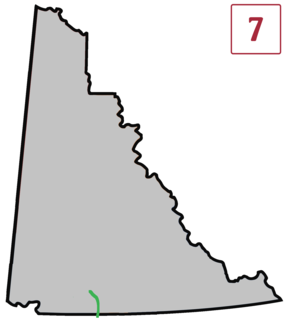
WPrince Edward Island Route 7 is a secondary highway in central Prince Edward Island. The short connecting route begins at an intersection with Route 2 west of Charlottetown, and runs north to Oyster Bed Bridge, where the road continues as Route 6. It is an uncontrolled, paved two-lane road for its entire length.
 W
WRoute 13 is a 39 km (24 mi) two-lane uncontrolled access secondary highway traversing the central portion of Prince Edward Island, Canada in a more or less north–south direction between Crapaud and Cavendish. It passes through a mainly rural area of Prince Edward Island. A portion of Route 13 is commonly called the "Hopalong Road."
 W
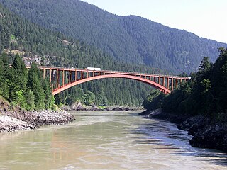
WThe Alexandra Bridge is a steel arch-span bridge crossing the Fraser River on the north side of Spuzzum, British Columbia and 39 km from Hope, on the Trans-Canada Highway in the Fraser Canyon region of southern British Columbia, Canada. It was constructed between 1960 and 1964 and is the third structure in the area named the Alexandra Bridge.
 W
WThe Atlin Road is a road in British Columbia and Yukon, Canada. It is designated as Highway 7 in Yukon, and has no official highway number in British Columbia.
 W
WThe Aviation Parkway is a parkway in Ottawa, Ontario, Canada.
 W
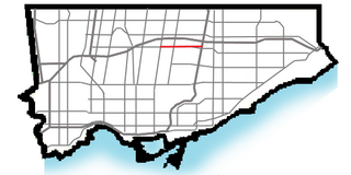
WBeverley Street is a minor thoroughfare located in the central area of Toronto, Ontario. It is a two-lane road serving both directions with additional bicycle lanes along the curb side of the fully paved roadway. Due to these exclusive "bike lanes," the road acts as the principle north-south cyclist route for the western side of Toronto's downtown area. Beginning at Queen Street West and terminating at College Street, the road continues northbound turning into St. George Street, which runs through the main campus of The University of Toronto. The street is approximately one kilometre in length. Points of interest along the street include: the Grange Park, the Art Gallery of Ontario, the Italian Consulate General, the George Brown House, and the Polish Combatants of WW2 Hall. It is of general consensus among locals that the road acts as the division between the Grange and Baldwin Village neighbourhoods on the east side of the street and Toronto's main Chinatown on the west side, respectively. It is designated bicycle route #35 in Toronto's cycle network.
 W
WHighway 13 is an 11.5 km (7.1 mi) long two-lane route through the eastern part of Langley, British Columbia. Highway 13 essentially serves the function of quick access from Washington state to the central Fraser Valley, and vice versa. Highway 13 first opened in 1958 between the Canada–United States border and the present day Fraser Highway, and was extended north to the present day Trans-Canada Highway in 1968.
 W
WHighway 91A, or the Queensborough Connector, is a 3 km (2 mi) long spur off Highway 91. Highway 91A crosses the Queensborough Bridge and terminates at Marine Way, allowing traffic into New Westminster. Residents of New Westminster can use Highway 91A as a convenient route towards the Canada/U.S. border. Although the Queensborough Bridge has existed since the 1950s, the highway spur section was opened only in 1986, at the same time the first section of Highway 91 was completed.
 W
WCanusa Street is the only part of the Canada–United States border that runs down the middle of a street. The street separates Beebe Plain, Vermont from the Beebe Plain area of Stanstead, Quebec and is a part of Quebec Route 247.
 W
WThe Cataraqui Trail is a 104-km Rails-to-Trails multi-use linear recreational trail in Eastern Ontario, Canada. The route passes by farmland, woods, lakes, and wetlands. The trail begins southwest of Smiths Falls, at a parking lot south of Ontario Highway 15 designated as kilometre zero.
 W
WThe Dalton Trail is a trail that runs between Pyramid Harbor, west of Haines, Alaska in the United States, and Fort Selkirk, in the Yukon Territory of Canada, using the Chilkat Pass. It is 396 km (246 mi) long.
 W
WDouglas Street is a road in Victoria, British Columbia. It is named after Sir James Douglas, the second Governor of the Colony of Vancouver Island. A segment of the Trans-Canada Highway, the main part of Douglas Street runs approximately 5 km (3 mi) from Dallas Road on the Georgia Strait to just north of Saanich Road, where the Trans-Canada curves westward towards the Western Communities.
 W
WThe Elora Cataract Trailway is a 47 km-long recreational rail trail between the towns of Elora and Forks of the Credit, in the south of the province of Ontario, Canada. The former Canadian National Railway line operated from about 1880 until 1988.
 W
WFan Tan Alley (番攤里) is an alley in the Chinatown neighbourhood of Victoria, British Columbia, Canada. It runs south from Fisgard Avenue to Pandora Avenue at the block between Government Street and Store Street. Named after the Chinese gambling game Fan-Tan, the alley was originally a gambling district with restaurants, shops, and opium dens. Today it is a tourist destination with many small shops including a barbershop, art gallery, Chinese cafe, apartments and offices. It is the narrowest street in Canada. At its narrowest point it is only 0.9 meters (35 in) wide. It was designated as a heritage property by the local government in 2001.
 W
WThe Galloping Goose Regional Trail is a 55-kilometre (34 mi) rail trail between Victoria, British Columbia, Canada, and the ghost town of Leechtown, north of Sooke, where it meets the old Sooke Flowline. The trail forms part of the Trans-Canada Trail, and intersects the Lochside Regional Trail. It is maintained by the Capital Regional District (CRD).
 W
WGladstone Avenue is a street in Ottawa running east from the Rideau Canal west to Parkdale Avenue. It is a historically residential street running just south of the downtown core, with a number of small houses in the downtown section now converted to commercial uses. The local pronunciation is phonetic, unlike that of William Ewart Gladstone's surname.
 W
WGovernment Street is a major road in Victoria, British Columbia.
 W
WGrant McConachie Way is a three-to-six lane expressway in Richmond and Vancouver, British Columbia, Canada. Named for aviator Grant McConachie, it is the primary access road into Vancouver International Airport on Sea Island. It is also one of the three roads entering Vancouver from the south, along with Knight Street and Oak Street. Upon entering Vancouver, the road becomes Southwest Marine Drive.
 W
WHog's Back Road is a 1 km (0.62 mi) road in Ottawa, Ontario, Canada. The road connects Meadowlands Drive and Prince of Wales Drive to Riverside Drive and Brookfield Road. The road is used as the boundary line between Mooney's Bay Park and Hog's Back Park. It goes over the dam creating Mooney's Bay and Hog's Back Falls, and continues over the Hog's Back swing bridge over the Rideau Canal, to allow taller boats navigating the canal to pass. The road also runs past the spot where the Rideau Canal separates from the Rideau River.
 W
WHunt Club Road, also known as Ottawa Road 32, is a major east–west route in Ottawa, Ontario, Canada. It originally ran from a dead end east of Bank Street to the Hunt Club Golf Course; later, there were many extensions due to the 1970s housing boom, first westward to Riverside Drive, then eastward to Hawthorne Road in the late 1980s. The section between Bank Street and Riverside Drive, originally only one lane in each direction, was expanded to two lanes in each direction in 1993–1994. It was further extended across the Rideau River and the southern edge of the suburbs to Richmond Road by the late 1990s; this extension is signed as West Hunt Club Road by the City of Ottawa. Construction to extend Hunt Club eastward to Highway 417 near Ramsayville was completed on August 21, 2014.
 W
WHighway 4, known as the Ingraham Trail, extends from Yellowknife, Northwest Territories to Tibbitt Lake, approximately 70 km (43 mi) east of Yellowknife. It was built in the mid-1960s as the first leg of a 'road to resources' with the original intention of circulating Great Slave Lake.
 W
WKent Street is a major street in downtown Ottawa, Ontario, Canada. One block west of Bank Street, Kent is one way running north. It begins at the Queensway at the south and ends at Wellington Street. The street has fewer storefronts than Bank Street. South of downtown it is mainly small and medium-sized office buildings, with some restaurants and residences. The northern part of the street is home to several large office towers, mainly governmental. It was originally known as Hugh Street.
 W
WThe Liard Highway, designated Highway 77 in British Columbia and Highway 7 in the Northwest Territories, is a highway in Canada which forms the sole road connection between B.C. and the Northwest Territories.
 W
WThe Lochside Regional Trail is a 29-kilometre (18-mile) trail that runs from the Swartz Bay Ferry Terminal to Victoria, British Columbia, Canada. The trail is a popular route both for commuting and recreation. It is frequented by people walking, running, cycling, skateboarding and riding horses.
 W
WNicholas Street is an arterial road in the central area of Ottawa, Ontario which connects Highway 417 with the downtown core. Despite being a municipal road, the street is designated as part of Canada's National Highway System, as part of an interconnecting route between Highway 417 and Quebec Autoroute 5 in Gatineau.
 W
WO'Connor Street is a downtown arterial road in Ottawa, Ontario, Canada. It is a north-south route, operating one way southbound, providing a key thoroughfare parallel to Bank Street.
 W
WThe Parc Linéaire Le P'tit Train du Nord is a multi-use recreational rail trail located in Quebec through the Rivière du Nord valley. It originally was a railway line operated by Canadian Pacific Railway which operated it at a continuous financial loss since its construction in the 1890s. During the 1990s, it was dismantled to make way for a recreational multi-use trail except for the portion between Montréal and Saint-Jérôme which is still in service as the Saint-Jérôme line. Prior to decommissioning, passenger traffic on this line was so scarce that it gave way to the humorous and intricately philosophical and poetic song by Felix Leclerc, "Le train du nord".
 W
WThe Prescott-Russell Recreational Trail is a 72 kilometres (45 mi) long rail trail in Prescott-Russell, Ontario, Canada, maintained by the county of Prescott-Russell. The trail begins in the village of Saint-Eugène and goes to the eastern boundary of the City of Ottawa, passing through the townships of East Hawkesbury, Champlain, The Nation, Alfred and Plantagenet, and Clarence-Rockland.
 W
WPreston Street is a street in Ottawa, Ontario, Canada, running between Scott Street in the north and Prince of Wales Drive and Queen Elizabeth Driveway in the south. It is the main commercial artery in Little Italy, home to numerous small business and Italian restaurants, and is synonymous with "Little Italy" to many Ottawa residents when referring to area businesses.
The Saint Clair Parkway is maintained by the Saint Clair Parks Commission. The road was the original Highway 40, which was re-aligned about 5 km inland from the river on a new alignment as a Super-2 expressway from Wallaceburg to Sarnia. The road provides a nice alternative or scenic route from Wallaceburg to Sarnia, going through the towns of Port Lambton, Sombra, Courtright, and Corunna. It turns west along Vidal St. and Churchill Line, meeting its new alignment in the southern area of Sarnia.
 W
WThe Sentier NB Trail is a network of hiking trails in New Brunswick, Canada built on abandoned railways. The trails are mostly closed to motorized vehicles. The network is operated by the New Brunswick Trails Council, a non-profit organization. Some portions of the trail are also part of the Trans Canada Trail.
 W
WThe Silver Trail, officially Yukon Highway 11, is a highway in the Canadian territory of Yukon connecting the communities of Mayo and Keno City with the Klondike Highway at Stewart Crossing. It was originally built in 1950-51 as the Whitehorse–Mayo Road, and originally designated as Highway 2. The route was renumbered in 1978 as Highway 11, and in the mid-1980s was given its current name to reflect to the historic operations of silver mining in the district.
 W
WThe Spurline Trail is a multi-use urban rail with trail which connects the cities of Waterloo and Kitchener, Ontario, Canada. Its northern trailhead is at the point where the CN Waterloo Spur crosses Laurel Creek; it connects to the Laurel Trail there, and is close to Uptown Waterloo. Its southern trailhead is at Ahrens Street West near its intersection with Breithaupt Street, close to Kitchener station and downtown Kitchener. The trail is 2.4 kilometres (1.5 mi) long, the entirety of which is paved. For its whole length, the trail runs parallel and to the north of the CN Waterloo Spur, stopping just short of where the Waterloo Spur joins the GO Transit Guelph Subdivision mainline at a junction just east of Kitchener station.
 W
WTuktoyaktuk Winter Road, an extension of the Dempster Highway, was an ice road on frozen Mackenzie River delta channels and the frozen Arctic Ocean between the Northwest Territories communities of Inuvik and Tuktoyaktuk, in Canada. The road closed permanently on 29 April 2017 at the end of the 2016-2017 winter season. Construction of an all-season highway between Inuvik and Tuktoyaktuk commenced in April 2013; it opened on 15 November 2017.
 W
WWalkley Road is a major road in Ottawa, Ontario, Canada. It runs from Riverside Drive to Ramseyville Road. It is mostly a four-lane divided road which runs through both residential and industrial areas of the southern part of urban Ottawa.
 W
WWater Street is a street in the Gastown area of Vancouver, British Columbia. It is named for its proximity to the water, in this case the south shore of Burrard Inlet, and was briefly known as Front Street. Water Street is popular amongst tourists; its most famous landmark is the steam clock.
 W
WThe Ahousaht Wildside Heritage Trail is a hiking trail on Flores Island, British Columbia, Canada in Ahousaht Traditional Territories that connects the town of Ahousat, the village of Marktosis, to several beaches and wild forest and is 11 km (6.8 mi) long one way ending in Cow Bay. The trail features signage at locations important to the Ahousat people; further information about each location of importance is shared in a guidebook published by Elder Stanley Sam.
 W
WThe Yellowknife Highway, officially Northwest Territories Highway 3 and also known as the Great Slave Highway, is a highway connecting Yellowknife, Northwest Territories to the Mackenzie Highway, from a junction 188 km (117 mi) north of the Alberta border. First completed in 1960 as a gravel and dirt road, the highway is now paved and realigned after years of work concluded in 2006. Access to Yellowknife from prior to the opening of the Yellowknife Highway, was only possible by airplane, winter road, or boat across Great Slave Lake.
 W
WYork Mills Road is an east-west route in Toronto, Ontario, Canada named for the historic village of York Mills that was located on the hill immediately north of today's intersection of York Mills Road and Yonge Street. The village of York Mills is distinguished from the 1920s subdivision to the south known as Hoggs Hollow. "York" refers to York Township and "Mills" refers to the gristmills and sawmills that once operated (1804–1926) in the valley through which the Don River runs.