 W
WAnse de Mai is a fishing village in the northeast of Dominica, located between the towns of Calibishie and Portsmouth. In 2013 Atlantique View Resort & Spa opened in Anse de Mai.
 W
WBataka is a small town in Dominica. It is located in the northeast of the island, between Pagua Bay and Salybia.
 W
WCabrits National Park is on a peninsula at the north end of the Caribbean island of Dominica, north of Portsmouth. The park protects tropical forest, coral reefs and wetlands. There are hiking trails and an English garrison called Fort Shirley. Cabrits National Park occupies 1,313 acres and was established in 1986.
 W
WCastle Bruce is a village on the east coast of Dominica. It is the largest settlement in St. David Parish, with a population of 1,339.
 W
WColihaut is a coastal village in northern Dominica within Saint Peter Parish midway between the towns of Roseau and Portsmouth. It has a population of 773 people.
 W
WCoulibistrie is a village on the west coast of Dominica, in the northwest corner of Saint Joseph Parish. It is between the villages of Colihaut to the north and Morne Rachette to the south. It extends inland from the coast within a deep valley, along both banks of the Coulibistrie River. It is primarily residential with few businesses. Many of the houses are built directly atop or adjoining the numerous large boulders that litter the valley along its base.
WDelices is a small village in Dominica. It is located in the south-east of the island, between La Plaine and Petite Savanne.
 W
WDominica Passage is a strait in the Caribbean. It separates the islands of Dominica, from Marie-Galante, Guadeloupe. It is a pathway from Caribbean sea into Atlantic ocean.
 W
WGalion, also spelled Gallion, is a mountain village in the south of Dominica, with a population of 134.
WGrand Bay, known officially as Berekua or Berricoa, is a village in the south of Dominica. It has a population of 2,288 as of 2010, and is the largest settlement in St. Patrick Parish.
 W
WHampstead is a village in northeastern Dominica. Along with Bense, the area has a population of 495, and was used as a filming location for 2006's Pirates of the Caribbean: Dead Man's Chest.
 W
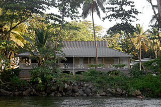
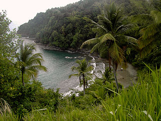
WLaudat is a small village in the interior of Dominica, located between 3 mountains: Morne Watt, Morne Micotrine, and Morne Trois Pitons. With a population of just above 300 persons, Laudat is referred to as a "gateway" because it is the sole entry point to many of the islands sights, including the Boiling Lake, Fresh Water Lake, and Titou Gorge. Perched about 1200 feet above sea level Laudat has a cool climate and views of the Caribbean Sea. It is located approximately 20 minutes from the capital, Roseau and is at the end of the road. The road to Laudat used to be a hair-raising ride up the mountains, around blind hairpin turns with sharp drop-offs into the jungle canopy; however, the road has been improved and may be completed by the time of this writing. Laudat has seen many changes over the past years, including the aerial tram taking visitors from the village up into the high mountains--making possible what was previously a journey by foot. Titou Gorge was also altered over the last decade, and is now smaller and more developed. It is still a swimming place, and small waterfalls of hot and cold water stream into the gorge. There are some overnight accommodations available in the village. There are also a few small shops of the kind typically found throughout the Caribbean; rum, soft drinks and a few grocery and household items can be found. Laudat receives some of the highest rainfalls in the Caribbean, about 900 cm a year. The air is often misty and cool - a change from the heat of lower-lying areas.
 W
WThere are three National parks in Dominica. Other protected areas include two Forest Reserves and the Syndicate Parrot Preserve.
 W
WMahaut is a village on the west coast of Dominica. It has a population of 2,399, and was home to Dominica Colgate-Palmolive until the factory was closed in 2015 after Hurricane Erica.
 W
WMarigot is the largest settlement of Saint Andrew Parish in northeastern Dominica. The village has a population of 2,676 people, and is home to a Fisheries Complex as well as the island's main airport.
 W
WMartinique Passage is a strait in the Caribbean that separates Dominica and Martinique.
 W
WMassacre is a town in Saint Paul Parish, Dominica, with about 1,200 inhabitants. It is located on the central west coast of the island, to the north of the capital, Roseau, on the Massacre River.
 W
WMorne Diablotin National Park is a national park in the northern mountain ranges of Dominica, an island nation in the Caribbean. The park comprises 8,242 acres, amounting to 4.4% of the nation's area. It was established in January 2000, primarily to protect the habitat of the endangered sisserou parrot, an endemic bird species that is a national symbol of Dominica.
WMorne Diablotins is the highest mountain in Dominica, an island-nation in the Caribbean Lesser Antilles. It is the second highest mountain in the Lesser Antilles, after La Grande Soufrière in Guadeloupe. Morne Diablotins is located in the northern interior of the island, about 15 miles north of Dominica's capital Roseau and about 6 miles southeast of Portsmouth, the island's second-largest town. It is located within Morne Diablotin National Park.
 W
WMorne Plat Pays is a volcano on the island of Dominica. Located on the southern region of the island, the volcano last erupted around the year 1270 AD. Since the mid-18th century, a number of earthquake swarms have occurred near the mountain, but these are not related to Morne Plat Pays' eruptive activity.
 W
WMorne Rachette or Morne Raquette is a village on the west coast of Dominica, in the northwest corner of Saint Joseph Parish. It is located on the slopes of Morne Jalousie, above Coulibistrie to its immediate north and Batalie Bay. The village of Salisbury is south of Morne Rachette.
 W
WMorne Watt or Watt Mountain is a mountain consisting of one or more stratovolcanoes at the south end of Dominica in the eastern Caribbean Sea. With an elevation of 1,224 m (4,016 ft), it is the third highest mountain in Dominica after Morne Diablotins and Morne Trois Pitons. The mountain is home to the Boiling Lake and Valley of Desolation thermal areas, both of which are the best-known volcanic features in Dominica and major tourist attractions in Morne Trois Pitons National Park.
WPaix Bouche is a village in northern Dominica. It has a population of 306, and has one of the island's steepest roads. The name comes from the local Creole expression meaning "shut your mouth".
 W
WDominica is divided into ten parishes.The largest parish by population in Dominica is Saint George which contains the capital city Roseau and has a total population of 21,241. The smallest parish by population is Saint Peter with 1,430 residents. The largest parish by land area is Saint Andrew which spans 179.9 km2 (69.5 sq mi), while Saint Luke is the smallest at 10.8 km2 (4.2 sq mi).
WPenville or Pennville is a village in Dominica's Saint Andrew Parish. The community is situated just north of Vieille Case, and has a population of 524.
 W
WPointe Michel is a small town on the southwest coast of Dominica. It is located to the south of the capital, Roseau, and is known for being the birthplace of Dominica's first female Prime Minister, Dame Eugenia Charles.
 W
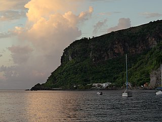
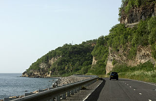
WPortsmouth is the second largest town in Dominica, with 2,977 inhabitants. It lies on the Indian River on Dominica's northwest coast, in Saint John Parish. Cabrits National Park is located on a peninsula to the north of town. Portsmouth has its own sea port in Prince Rupert Bay.
 W
WRosalie is a village in Dominica. It is located in Saint David Parish at the northern end of Rosalie Bay, on the central east coast of the island, close to the mouth of the Rosalie River.
 W
WSaint Andrew is one of Dominica's 10 administrative parishes. It is bordered by St. John and St. Peter, St. Joseph, and St. David.
 W
WSaint David is one of Dominica's ten administrative parishes, located on the eastern side of the island. It is bordered by St. Andrew to the north; St. Joseph, St. Paul and St. George to the west; and St. Patrick to the south. It has an area of 131.6 km² (50.8 mi²), and has a population of 6,789.
 W
WSaint George is one of Dominica's 10 administrative parishes. It is bordered by Saint Paul and part of the Boeri River, Saint David and Saint Patrick, Saint Luke.
WSaint John is one of Dominica's 10 administrative parishes. It is bordered by St. Andrew to the east, and St. Peter and the Espagnole River to the south. It has an area of 59 km² (22.78 mi²).
 W
WSaint Joseph is one of Dominica's 10 administrative parishes. It is bordered by St. Peter to the north, St. Andrew to the northeast, St. David to the east, and St. Paul to the south. It has an area of 120.1 km² (46.37 mi²), and a population of 5,765.
WSaint Joseph is the chief settlement of Dominica's St. Joseph Parish. Its population is 2,029.
WSaint Luke is one of Dominica's 10 administrative parishes. It is bordered by St. George, St. Mark, and St. Patrick.
 W
WSaint Mark is one of Dominica's ten administrative parishes. It is bordered by St. Luke and St. Patrick. With an area of 9.9 km² (2 mi²), it is the smallest in the island. It had a population of 1,834 people at the Population Census of 2011.
 W
WSaint Patrick is one of Dominica's 10 administrative parishes. It is bordered by St. George, St. Luke and St. Mark to the west, and St. David to the north. It has an area of 84.4 km² (32.59 mi²), and has a population of 8,383.
WSaint Paul is one of Dominica's 10 administrative parishes. It is bordered by St. Joseph to the north, St. David to the east, and St. George to the south. It has an area of 67.4 km² (26.02 mi²), and a population of 8,397.
 W
WSaint Peter is one of Dominica's 10 administrative parishes. It is bordered by St. John to the north, St. Joseph to the south, and St. Andrew to the east. It has an area of 27.7 km² (10.74 mi²), and has a population of 1,452. Colihaut, Dublanc and Bioche are its only settlements.
 W
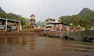
WSoufrière is a village on the southwest coast of Dominica. It is the capital of Saint Mark Parish and has a population of 1,416 people.
 W
WTrafalgar is a village in inland Dominica, located to the northeast of the capital, Roseau, and close to Morne Trois Pitons, the mountain which dominates the southern centre of the country.
 W
WWotten Waven is a village in Dominica's Roseau Valley. It has a population of 226 people.