 W
WAchada Fazenda is a settlement in the eastern part of the island of Santiago, Cape Verde. In 2010 its population was 2,592. It is situated near the east coast, 2 km southeast of Pedra Badejo, near the estuary of the Ribeira Seca.
WAchada Monte is a town in the northern part of the island of Santiago, Cape Verde and is part of the municipality of São Miguel. It is situated near the east coast, 8 km northwest of Calheta de São Miguel. In 2010 its population was 1,652. It is on the road connecting Praia and Tarrafal through Pedra Badejo, the EN1-ST02. The small bay Mangue de Sete Ribeiras is located east of the settlement. Ribeira Principal flows west of the village.
 W
WBaía das Gatas is a village in the northeastern part of the island of Sao Vicente, Cape Verde. It is situated on the east coast, 4 km east of Salamansa and 8 km east of the island capital Mindelo. It takes its name from the bay it is situated on, also named Baía das Gatas. The bay was mentioned as "B. des Ghat" in the 1747 map by Jacques-Nicolas Bellin.
 W
WCalheta de São Miguel is a city in the northern part of the island of Santiago, Cape Verde. In 2010 its population was 3,175. It is on the east coast, 31 km (19 mi) north of the capital Praia. It is the seat of São Miguel municipality.
 W
WCalheta is a town in the western part of the island of Maio. It is situated on the Atlantic coast, around 11 km north of the island capital Porto Inglês and 6 km north of Morro. Its population at the 2010 census was 1,156, making it the island's second most populous settlement. The settlement was mentioned as "Kalyete" in the 1747 map by Jacques-Nicolas Bellin.
WCancelo is a settlement in the eastern part of the island of Santiago, Cape Verde. It is part of the municipality Santa Cruz. It is situated near the east coast, 4 km northwest of Pedra Badejo and 5 km southeast of Calheta de São Miguel. In 2010 its population was 2,042.
WCarriçal is a settlement in the eastern part of the island of São Nicolau, Cape Verde. It is situated on the south coast, 8 km southeast of Juncalinho and 24 km east of Ribeira Brava. It is the easternmost settlement on the island. Some 8 km east is the island's easternmost point, Ponta Leste. The place was mentioned as Currissal in the 1747 map by Jacques-Nicolas Bellin.
WChão Bom is a settlement in the northern part of the island of Santiago, Cape Verde. It is situated near the west coast, 3 km southeast of Tarrafal on the main road (EN1-ST01) south to Assomada and Praia. In 2010 its population was 5,166. The Tarrafal prison camp was situated north of Chão Bom. The stadium Estádio de Mangue is in the northwestern part in the communal limits. Silvino Lopes Évora, a writer, poet, journalist and a university professor is native to Chão Bom.
 W
WFajã de Agua is a village on the northwestern coast of the island of Brava, Cape Verde. It is 4 km west of the island capital Nova Sintra. Fishing and agriculture are the most important sources of income.
 W
WFurna is a seaside community in the northeastern part of the island of Brava, Cape Verde. It lies 2.5 km northeast of the island capital of Nova Sintra. At the 2010 census its population was 612.
 W
WJanela is a settlement in the eastern part of the island of Santo Antão, Cape Verde. It is situated on the Atlantic coast, 4 km southeast of Pombas and 14 km northeast of the island capital Porto Novo The central village, Pontinha, lies on a rocky peninsula. More villages are situated in the valley of the river Ribeira da Janela. The national road from Porto Novo to Pombas (EN1-SA03) passes through Janela.
 W
WPorto Inglês is a city in the southwestern part of the island of Maio in southeastern Cape Verde. It is the main urban settlement of the island, and also seat of the Maio Municipality. Its population was 2,971 in 2010. The name Porto Inglês refers to English ships that exported salt produced on the island of Maio from this town. Salt exploitation continued until the 19th century. The inconclusive Battle of Maio was fought between British and French frigate squadrons close to the town on 23 January 1814 in the last stages of the Napoleonic Wars.
WMato Correia is a village in the northeastern part of the island of Santiago, Cape Verde. It is part of the municipality of São Miguel. It is located southwest of Espinho Branco, 1.5 km north of Pilão Cão and 5 km northwest of São Miguel. In 2010 its population was 328.
WMonte Trigo is the westernmost settlement on the island of Santo Antão, Cape Verde. It is situated on the coast, at the foot of the Tope de Coroa, the highest mountain of the island. It is 28 km west of the island capital Porto Novo. In 2010 its population was 274. About 5 km to the northwest is Ponta do Chão de Mangrade, the westernmost point of all Africa.
 W
WMosteiros is a city in the northeastern part of the island of Fogo, Cape Verde. It is situated on the coast, 24 km northeast of the island capital São Filipe. It is the seat of the Mosteiros Municipality and of the civil parish Nossa Senhora da Ajuda. At the 2010 census its population was 9,524 making it the island's second most populated place.
 W
WPalmeira is a town in the northwestern part of the island of Sal, Cape Verde. In 2010 its population was 1,420. The town is situated on the west coast, about 4 km west of the island capital Espargos. Located at Baía de Palmeira, a small bay south of the village, it is home to the main port of the island of Sal. It is the third busiest port of Cape Verde in freight traffic.
 W
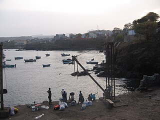
WPedra Badejo is a city in the eastern part of the island of Santiago, Cape Verde. It is on the east coast, 25 km (16 mi) north of the island capital Praia, 8 km (5.0 mi) southeast of Calheta de São Miguel and 15 km (9.3 mi) east of Assomada. It is the seat of Santa Cruz municipality. At the 2010 census, the town had 9,859 inhabitants.
 W
WPedra de Lume is a village in the northeastern part of the island of Sal, Cape Verde. The village is situated on the east coast, about 5 km east of the island capital Espargos. It has a small port and a lighthouse, Farol de Pedra de Lume.
 W
WPombas is a city in the northeastern part of the island of Santo Antão, Cape Verde. It is the seat of the municipality Paul. It is situated on the coast, at the mouth of the Ribeira do Paul, 7 km (4.3 mi) southeast of Ribeira Grande and 15 km (9.3 mi) north of the island capital Porto Novo. The national roads EN1-SA02 and EN1-SA03 connect Pombas with Ribeira Grande and Porto Novo, respectively. Pombas was elevated from town to city in 2010.
 W
WPonta do Sol is the northernmost city on the island of Santo Antão and Cape Verde. It is situated on the coast, 4 km northwest of Ribeira Grande and 20 km north of the island capital Porto Novo. It is the seat of Ribeira Grande municipality.
WPonta Verde is a seaside settlement in the northeastern part of the island of Santiago, Cape Verde. It is a suburb of the city of Calheta de São Miguel, part of the municipality of São Miguel. It is situated on the Praia-Pedra Badejo-Tarrafal Road (EN1-ST02), 1.5 km northwest of the centre of Calheta de São Miguel. In 2010 its population was 1,065.
WPorto Gouveia is a settlement in the southern part of the island of Santiago, Cape Verde. It is situated on the south coast, 7 km northwest of Cidade Velha. It is part of the municipality of Ribeira Grande de Santiago.
WPorto Mosquito is a settlement in the southern part of the island of Santiago, Cape Verde. It is situated on the south coast, 10 km northwest of Cidade Velha. It is part of the municipality of Ribeira Grande de Santiago.
 W
WPorto Novo is a city in the island of Santo Antão, in Cape Verde. It is the seat of the Porto Novo municipality. At the 2010 census, the town had 9,310 inhabitants, which makes it the most populous settlement of the island.
 W
WPraia is the capital and largest city of Cape Verde. Located on the southern coast of Santiago island, within the Sotavento Islands group, the city is the seat of the Praia Municipality. Praia is the economic, political, and cultural center of Cabo Verde.
WPraia Baixo is a village in the southeastern part of the island of Santiago, Cape Verde. It is part of the municipality of São Domingos and the parish of Nossa Senhora da Luz. It is situated on the east coast, 1.5 km northwest of Achada Baleia, 11 km southeast of Pedra Badejo, 10 km east of São Domingos and 16 km north of the capital Praia. In 2010 its population was 952.
WPraia Branca is a town in the northwestern part of the island of São Nicolau, Cape Verde. It is part of the municipality of Tarrafal de São Nicolau. Its population at the 2010 census was 521. It is situated 2 km from the coast, 10 km northwest of Ribeira Brava.
WPreguiça is a settlement in the central part of the island of São Nicolau, Cape Verde. It is situated on the south coast, 6 km south of Ribeira Brava. It served as the port of Ribeira Brava, after the older Porto de Lapa, 6 km to the northeast, had been abandoned in 1653 due to pirate attacks. The settlement was mentioned as Paraghisi in the 1747 map by Jacques-Nicolas Bellin. In 1820 the Forte do Príncipe Real, now ruined, was built to protect the port. Preguiça's port consists of a stone quay and a short mole. Preguiça Airport is located 3 km north of the village.
 W
WRibeira da Barca is a town in the municipality of Santa Catarina, on the island of Santiago, Cape Verde. In 2010 its population was 2,317. It is situated on the west coast, at the mouth of the stream Ribeira da Barca, 11 km northwest of Assomada. The settlement was mentioned as "Rivera das Baras" in the 1747 map by Jacques-Nicolas Bellin.
 W
WRibeira de Calhau is a settlement in the eastern part of the island of Sao Vicente, Cape Verde. It takes its name from the river Ribeira do Calhau, and comprises the villages of Madeiral, Ribeira de Calhau and Calhau. Madeiral and Ribeira de Calhau are located in the river valley, Calhau is on the east coast. In 2010 its population was 1,177. The valley is surrounded by the mountains Viana, Madeiral, Pico do Vento and Monte Verde.
 W
WRibeira Grande is the largest town of the Ribeira Grande Municipality on the island of Santo Antão, Cape Verde. It has become a city in 2010. In 2010 its population was 2,564. It is situated in the northeastern part of the island, near the outflow of the river Ribeira Grande and its tributary Ribeira da Torre into the Atlantic Ocean. Neighborhoods include Tarrafal, Rua de Agua, Rua d'Horta and Penha de França.
WRibeira da Prata is a town in the northern part of the island of Santiago, Cape Verde belonging to the municipality of Tarrafal. In 2010 its population was 1,009. It was mentioned as Rivera de Prata in the 1747 map by Jacques-Nicolas Bellin.
WRincão is a settlement in the western part of the island of Santiago, Cape Verde. In 2010 its population was 1,048. It is situated on the west coast, 6 km southwest of Assomada. The westernmost point of the island, Ponta da Janela, lies 2 km to the northwest.
 W
WSal Rei is a city on the northwestern coast of the island of Boa Vista in eastern Cape Verde. Sal Rei is the island's main urban settlement, and the seat of the Boa Vista Municipality. In 2010 its population was 5,778. The name of the settlement means "Salt King" in Portuguese. This name stems from when the island's main industry was salt production.
 W
WSanta Maria is a city in the southern part of the island municipality of Sal, Cape Verde. It is located on the south coast, about 16 km south of the Amílcar Cabral International Airport, and 20 km south of the island capital Espargos.
 W
WSão Filipe is a city on the west coast of the island of Fogo, Cape Verde. It is the capital of the island, and the seat of the São Filipe Municipality. The island's airport, São Filipe Airport, is located on the southeastern edge of the town and the island's port is 4 km north of the center at Vale de Cavaleiros. The town's elevation is 20 meters.
 W
WSão Pedro is a village in the southwestern part of the island of Sao Vicente, Cape Verde. It is situated on the south coast, approximately 10 km southwest of the island capital Mindelo. In 2010 its population was 991. Cesária Évora Airport, the island's international airport is directly north of São Pedro. It was mentioned as a small port as "P. St. Pedro" in the 1747 map by Jacques-Nicolas Bellin. The lighthouse Farol de D. Amélia sits on the Ponta Machado, 3 km west of the village.
WSinagoga is a settlement in the northeastern part of the island of Santo Antão, Cape Verde. It is situated on the coast, 4 kilometers east of Ribeira Grande and 18 km north-northeast of the island capital Porto Novo. It is situated on the national road connecting Ribeira Grande and Pombas (EN1-SA02).
WTarrafal de Monte Trigo is a settlement in the southwestern part of the island of Santo Antão, Cape Verde. In 2010 its population was 841. It is situated on the coast, 27 km west of the island capital Porto Novo. The settlement was mentioned as Terrafal in the 1747 map by Jacques-Nicolas Bellin.
 W
WTarrafal de São Nicolau is a city in the western part of the island of São Nicolau, Cape Verde. With a population of 3,733, it is the most populous settlement of the island. It is the seat of the Tarrafal de São Nicolau Municipality, and the main port of the island. It is situated on the west coast, 9 km southwest of Ribeira Brava.
 W
WTarrafal is a city in the northern part of the island of Santiago, Cape Verde. In 2010 its population was 6,656. It is a fishing port situated on the northwestern coast. It constitutes the seat of the Tarrafal Municipality.
WVeneza is a settlement in the northeastern part of the island of Santiago, Cape Verde. It is part of the municipality of São Miguel. It is a suburb of the city of Calheta de São Miguel, north of the city centre. It is situated on the coast, along the Praia-Pedra Badejo-Tarrafal Road (EN1-ST02). In 2010 its population was 1,375.