 W
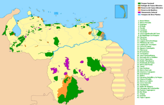
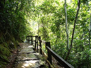
WThe national parks of Venezuela are protected areas in Venezuela covering a wide range of habitats. In 2007 there were 43 national parks, covering 21.76% of Venezuela's territory.
 W
WThe Aguaro-Guariquito National Park Also Aguaro Guariquito National Park Is a protected area with the status of national park in the South American country of Venezuela located in the region of the central plains of the south in the Guárico state. It extends over the municipalities of Francisco de Miranda and Las Mercedes. It was established on March 7, 1974. It is spread over an area of 585,750 hectares (5857 km²).
 W
WThe Caura National Park is a protected area with the status of National Park in Venezuela. With an area of 7,534,000 ha. (75,340 km²) is the largest park in the country and the most recently created (2017).
 W
WThe Cerro El Copey National Park Also Cerro El Copey-Jóvito Villalba National Park Is a protected area with the status of a national park located to the east of the Caribbean island of Margarita, in the highest mountainous region of Nueva Esparta State in Venezuela. It was created in 1974 with the purpose of protecting an outstanding physiographic feature with an ecosystem that includes several plant formations, high levels of endemism and the only permanent water sources of the island.
 W
WCerro Saroche National Park is a Venezuelan national park located in the state of Lara, between Barquisimeto and Carora. The National Park was created in 1989.
 W
WThe Chorro El Indio National Park Is a national park of Venezuela located to the east of San Cristóbal, Táchira State, in the mountain range the Maravilla, has access by the highway San Cristóbal - Macanillo - Potosí.
 W
WThe Ciénagas del Catatumbo National Park Also Catatumbo Marshes National Park or Ciénagas de Juan Manuel National Park Is a protected area. of Venezuela.
 W
WThe Cueva de la Quebrada del Toro is a cave in the Sierra de Falcón in Falcón State, Venezuela. It is an active river cave, through which flows the largest known underground watercourse in Venezuela. It is protected as the Cueva de la Quebrada del Toro National Park.
 W
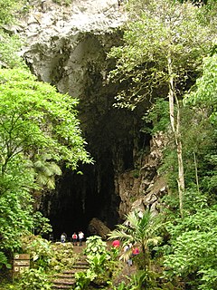
WThe Guácharo Cave National Park is located 12 km from the town of Caripe, Monagas, Venezuela. It has as its centerpiece a large limestone cave.
 W
WThe Dinira National Park is a protected area with the national park status located between the states Lara, Portuguesa and Trujillo in the South American country of Venezuela. It was created on November 30, 1988.
 W
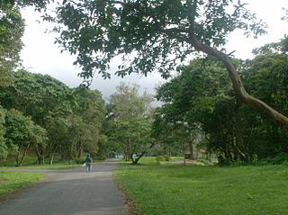
WThe Ávila National Park, officially known as Waraira Repano National Park for its name indigenous Cariban name, protects part of the Cordillera de la Costa Central mountain range, in the coastal region of central-northern Venezuela. The area's highest elevation is Pico Naiguatá, at 2,765 meters (9,072 ft) above sea level.
 W
WThe El Guache National Park Is a protected area with the status of national park in Venezuela, located at the beginning of the Andes mountain range, comprising mountainous parts of the Lara and Portuguesa states, and the birth of the Guache, Ospino, Toco, Morador and Are rivers. 2 In its adjacencies is the mighty waterfall San Miguel. It has an area of 12,200 ha traditionally measured and 15,960 Ha. Its temperature is between 19 °C. and 26 °C. Precipitation varies between 1800 and 2000 mm annually.
 W
WThe El Tamá National Park It is a protected area with the status of a national park that is located between the Andes and plains of Venezuela. It protects part of the Tamá Massif. It has an area of 139,000 hectares and is located in the states of Táchira and Apure, near the border with Colombia. Created as a National Park on December 12, 1978, by the then President Carlos Andrés Pérez.
 W
WThe General Juan Pablo Peñaloza National Park Also Páramos Batallón y La Negra National Park Is a national park of Venezuela that is formed by several páramos: Among them Batallón and La Negra, which are an important source of water supply. It is located between the states Mérida and Táchira, northwest of the Táchira depression in the Páramos de El Batallón and La Negra in Venezuela.
 W
WThe Guaramacal National Park Also General Cruz Carrillo National Park Is a protected area with the status of a national park located between the states of Portuguesa and Trujillo in the South American country of Venezuela. It has an area of about 214.66 km² and includes the Guaramacal Branch, the most northerly spur of the Cordillera de Mérida. The limits of the park are between 1600 and 1800 m in height, and the maximum elevation, in the moor of Guaramacal is to 3100 m.
 W
WThe Guatopo National Park Is a protected area with the status of national park in the north of the South American country of Venezuela. It is located specifically between the states of Miranda and Guárico, bordered on the north by the Cordillera de la Costa and the Barlovento Plain, on the south by the Piedemonte Llanero, on the east it borders on the continuation of the Serranía del Interior and The west with the continuation of the same Serranía and with the Valleys of the Tuy.
 W
WHenri Pittier National Park is the oldest national park in Venezuela, originally created in 1937 under the name of Rancho Grande by decree of President Eleazar López Contreras. In 1953 the park was renamed in honor of Henri Pittier, a distinguished Swiss geographer, botanist and ethnologist, who arrived in Venezuela in 1917, classified more than 30,000 plants in the country and devoted many years studying the flora and fauna in the park.
 W
WDuida–Marahuaca National Park is a protected area in Amazonas state, Venezuela. It has an area of 210,000 ha, and includes the Duida–Marahuaca Massif.
WJaua-Sarisariñama National Park is located in the Guayana Highlands, within Bolívar State of southeastern Venezuela. It was established in 1978.
 W
WThe Juan Crisostomo Falcón National Park, also known as the Sierra de San Luis, is in the southern part of the Falcón state in Venezuela. It has an area of 20,000 hectares covering the municipalities of Bolívar, Petit, and part of the municipalities of Colina and Miranda. It was created in 1987.
 W
WLaguna de la Restinga is a national park on the Isla Margarita, Nueva Esparta state, Venezuela. The main part of the park is a large salt lagoon, rich in fish and birdlife. It is on the Ramsar list of wetlands of international importance, and is classified as an Important Bird Area.
 W
WThe Laguna de Tacarigua National Park Also Tacarigua Lagoon National Park Is a protected area with the status of a national park located east of Miranda State, in the South American country of Venezuela. It comprises a permanent coastal lagoon of 7800 ha and 1.2 m of average depth, separated from the sea by a restinga or coastal barrier of 28.8 km long and 300–1000 m wide that was formed by the action of the sea current Which runs along the coast in an East-West direction.
 W
WThe Macarao National Park Is a protected area with the status of a national park located in the Macarao, San Pedro and Jarillo rivers, in the north of the South American country of Venezuela. Its extension of 15,000 hectares covers part of the Capital District and Miranda State. The area was declared National Park in 1973.
 W
WThe Mariusa National Park Also Delta del Orinoco National Park Is a protected area of Venezuela. with national park status
 W
WMédanos de Coro National Park is a Venezuelan national park located in the state of Falcón, near the city of Coro on the road that leads to Paraguaná. The National Park was created in 1974. The park is easily reached by bus or taxi from Coro.
 W
WMochima National Park is located in the States of Anzoátegui and Sucre (state), on the northeastern coast of Venezuela. The park covers 94,935 hectares and is made up of an exclusively marine area in its western sector, a coastal marine area that includes the Gulf of Santa Fé and Mochima Bay, and a mountainous area that covers the Turimiquire Dam watershed. Mochima Park was created to protect the montane forests of the Turimiquire Range and the country's eastern Caribbean Sea marine landscapes.
 W
WMorrocoy National Park is located in the easternmost coast of Falcón state and northwestern of Golfo Triste, in the west central Venezuelan coast, near the towns of Boca de Aroa, Tucacas, Sanare, Chichiriviche, Flamenco and Tocuyo de la Costa, and consists of 12,990 hectares. It was declared a national park on May 26, 1974 by Executive Order No. 113, Official Gazette No. 30408 on May 27, 1974.
WParima Tapirapecó National Park is a Venezuelan national park in the southern state of Amazonas.
 W
WThe Península de Paria National Park, or Peninsula of Paria National Park, Is a national park on Paria Peninsula in Venezuela.
WThe Río Viejo San Camilo National Park Also Rio Viejo-San Camilo National Park Is a protected area with the status of national park in the South American country of Venezuela. Specifically its territory is part of the state of Apure near the border with Colombia. It has an estimated area of 80,000 hectares, which constitute national park since 1 July 1993.
WThe San Esteban National Park is located in Carabobo, Venezuela.
 W
WThe Santos Luzardo National Park Also Cinaruco-Capanaparo National Park It is a protected area with the status of national park that is located between the rivers Capanaparo and Cinaruco and the confluence of them with the Orinoco river, in jurisdiction of the Municipalities Pedro Camejo and Achaguas of the Apure State in Venezuela, near the border with Colombia.
 W
WThe Serranía de la Neblina National Park is a national park of Venezuela.
 W
WThe Sierra La Culata National Park Also Sierra de la Culata National Park is a national park of Venezuela that is located in the northeastern branch of the Venezuelan Andes, in the states Mérida and Trujillo. It was decreed a national park on December 7, 1989. It has a high mountain climate, with temperatures ranging between −2 and 24 °C, and its surface area is 200,400 hectares (774 sq mi).
 W
WSierra de Perijá National Park, also known as Perijá National Park, is a protected area in Venezuela. It is located in the Serranía de Perijá mountains on the border with Colombia, to the southwest of Zulia state and Lake Maracaibo. The park was established in 1978 with the objective of protecting the hilly regions.
 W
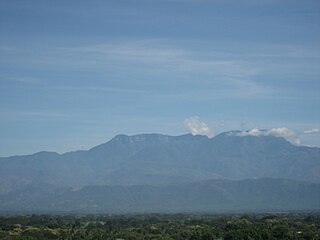
WThe Sierra Nevada National Park (PNSN) is an important National Park of Venezuela located between Mérida and Barinas states in the west of the country. It was created on May 2, 1952, by decree of President Germán Suárez Flamerich, in order to protect the Sierra Nevada de Mérida in the Andes.
 W
WThe Tapo-Caparo National Park Also National Park Tapo Caparo Is a protected area with the national park status in Venezuela, which covers an area estimated at 2,050 square kilometers and is administratively located between the states of Barinas, Mérida and Táchira, to the west of Venezuelan territory. National park was decreed The 14 of January 1992 in the government of the then president Carlos Andrés Pérez.
 W
WThe Terepaima National Park Is a protected area with the status of national park in the South American country of Venezuela located in the mountainous region of the Lara and Portuguesa States. Specifically southeast of the city of Barquisimeto, capital of the Lara State, it covers areas belonging to the municipalities Iribarren, Palavecino and Simón Planas.
 W
WTirgua National Park, also known as General Manuel Manrique National Park, is a national park in Venezuela. It protects the headwaters of several waterways, especially the river Tirgua, which gives its name to the park.
 W
WThe Turuépano National Park Is a protected area with national park status in the South American country of Venezuela, located in the Benítez, Cajigal, Libertador and Mariño municipalities in the eastern part of Sucre State, north of the San Juan River and in front of the Gulf of Paria.
 W
WThe Yacambú National Park is a protected area with national park status in the South American country of Venezuela. It is located in the south of the Lara State, on the southern slope of the Portuguesa Mountain Range, which forms part of the mountain foothills of the Andes Mountains. It was created in 1962 with the purpose of protecting part of the Yacambú river basin, whose waters will feed the reservoir José María Ochoa Pilé, an ambitious project still under construction. The reservoir is of vital importance for water supply in the city of Barquisimeto and for economic development in the dry valleys of Quibor, where there is a protected area of sustainable use for agricultural purposes.
 W
WThe Yapacana National Park Also Cerro Yapacana National Park Is a protected area with the status of national park in the South American country of Venezuela which was formed on December 12, 1978 by executive decree of President Carlos Andres Perez. It is located southwest of the confluence of the Ventuari River on the Orinoco River, in the jurisdiction of the Atabapo municipality of Amazonas state.
 W
WThe Yurubí National Park is a protected area with the status of national park in the north of the South American country of Venezuela. It was founded on March 18, 1960 in Yaracuy State created to protect the Yurubí river basin, which is the source of fresh water for the city of San Felipe. The Yurubí National Park is located in the mountains of the Sierra de Aroa. The park includes cloud forests and low montane forests and is surrounded by cultivated areas. The park is crossed by small trails, which are used mainly by poachers or by a small number of visitors and researchers. The park is not inhabited; The former settlers of the area were relocated many years ago.