 W
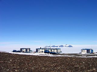
WAboa is a seasonal Finnish research station in Antarctica, located in Queen Maud Land, about 130 kilometres (81 mi) from the coast, on a nunatak called Basen in the Vestfjella Mountains.
 W
WAlan Peak also known as Alanpiggen, is a peak at the west side of the mouth of Reece Valley, in the south part of the Sverdrup Mountains in Queen Maud Land, Antarctica. Plotted from air photos by the Third German Antarctic Expedition (1938–39). Remapped by Norwegian cartographers from surveys and air photos by the Norwegian-British-Swedish Antarctic Expedition (NBSAE) (1949–1952) and air photos by the Norwegian expedition (1958–59). Named for Alan William Reece, geologist with the NBSAE (1949–52) and earlier with the Falkland Islands Dependencies Survey.
 W
WApollo Island is a small ice-covered island about 33 kilometres (18 nmi) east-northeast of Blåskimen Island in the northwest part of the Fimbul Ice Shelf, Queen Maud Land. The island is 19 kilometres (10 nmi) east-northeast of the site of the first three South African SANAE stations. The name Apollo appears to be first used on a South African map of 1969.
 W
WAtka Iceport, also known as Atka Bay, is an iceport about 10 miles (16 km) long and wide, marking a more-or-less permanent indentation in the front of the Ekstrom Ice Shelf on the coast of Queen Maud Land.
WBlåskimen Island is a high, ice-covered island about 15 kilometres (8 nmi) north of Novyy Island, at the juncture of the Jelbart Ice Shelf and the Fimbul Ice Shelf, Queen Maud Land. The island rises about 300 metres (1,000 ft) above the general level of the ice shelf and is surrounded by this ice, except for the north side which borders the sea. The feature was roughly delineated by Norwegian cartographers working with air photos taken by the Norwegian–British–Swedish Antarctic Expedition in 1951–52 and the Sixth Norwegian Antarctic Expedition in 1958–59. They called the island Blåskimen and included the area now called Novyy Island. The Soviet Antarctic Expedition mapped the feature in 1961 and showed it to be separated from Novyy Island.
 W
WCharles Glacier is a small, steep glacier draining the south side of Borg Mountain, in the Borg Massif of Queen Maud Land. It was mapped by Norwegian cartographers from surveys and from air photos by the Norwegian–British–Swedish Antarctic Expedition (NBSAE) (1949–52) and named for Charles W. Swithinbank, a glaciologist with NBSAE.
 W
WDrescher Inlet, also known as Dreschereisfrontkerbe, is an inlet or iceport in the front Riiser-Larsen Ice Shelf on the coast of Queen Maud Land, Antarctica. Some 25 km long and 3 km wide, it was named after Eberhard Drescher (1944–1983), a marine biologist at Germany’s Alfred Wegener Institute for Polar and Marine Research.
 W
WThe Ekström Ice Shelf is the ice shelf lying between Sorasen Ridge and Halvfarryggen Ridge, on the Princess Martha Coast of Queen Maud Land. It was first mapped by the Norwegian–British–Swedish Antarctic Expedition (NBSAE) (1949–1952), and named for Bertil Ekström, a Swedish mechanical engineer with the NBSAE, who drowned when the weasel he was driving plunged over the edge of Quar Ice Shelf on February 24, 1951.
WExplora Escarpment is an undersea escarpment named for the Antarctic science ship F.S. Explora. The name, proposed by Dr. Heinrich Hinze of the Alfred Wegener Institute for Polar and Marine Research, Bremerhaven, Germany, was approved by the Advisory Committee for Undersea Features in June 1997.
 W
WFestninga Mountain is a broad, ice-topped mountain, 2,535 metres (8,320 ft) high, standing west of Mount Hochlin at the west end of the Mühlig-Hofmann Mountains, in Queen Maud Land, Antarctica. it was mapped by Norwegian cartographers from surveys and air photos by the Sixth Norwegian Antarctic Expedition (1956–60) and named Festninga. Austvollen Bluff forms the east side of the mountain.
 W
WThe Fimbul Ice Shelf is an ice shelf about 200 km (120 mi) long and 100 km (62 mi) wide, nourished by Jutulstraumen Glacier, bordering the coast of Queen Maud Land from 3°W to 3°E. It was photographed from the air by the Third German Antarctic Expedition (1938–39), mapped by Norwegian cartographers from surveys and air photos by the Norwegian–British–Swedish Antarctic Expedition (1949–1952) and from air photos by the Norwegian expedition (1958–59) and named Fimbulisen.
WFlogeken Glacier is a deeply entrenched glacier, flowing northwest between Mount Grytoyr and Langfloget Cliff, in the Mühlig-Hofmann Mountains of Queen Maud Land, Antarctica. it was mapped by Norwegian cartographers from surveys and air photos by the Sixth Norwegian Antarctic Expedition (1956–60) and named Flogeken.
WGluvreklett Glacier is a glacier flowing northwest between Von Essen Mountain and Terningskarvet Mountain in the Gjelsvik Mountains of Queen Maud Land, Antarctica. It was photographed from the air by the Third German Antarctic Expedition (1938–39). It was mapped by Norwegian cartographers from surveys and photos by the Norwegian–British–Swedish Antarctic Expedition (1949–52) and the Norwegian expedition (1958–59) and named Gluvreklettbreen.
WHei Glacier is a glacier flowing northwest between the Hamrane Heights and the Robin Heights in the Sverdrup Mountains of Queen Maud Land, Antarctica. It was photographed from the air by the Third German Antarctic Expedition (1938–39). It was mapped by Norwegian cartographers from surveys and air photos by the Norwegian–British–Swedish Antarctic Expedition (1949–52) and from air photos by the Norwegian expedition (1958–59) and named Heibreen.
 W
WMount Hochlin is a large ice-topped mountain, 2,760 metres (9,060 ft) high, standing east of Festninga Mountain in the Mühlig-Hofmann Mountains of Queen Maud Land, Antarctica. It was mapped by Norwegian cartographers from surveys and air photos by the Sixth Norwegian Antarctic Expedition (1956–60) and named for L. Hochlin, a radio operator and dog driver with the expedition (1956–58).
 W
WHoggestabben Butte is a prominent butte, 2,410 metres (7,900 ft) high, standing 3 nautical miles (6 km) north of Mount Hochlin and being its highest northern outlier, in the Mühlig-Hofmann Mountains of Queen Maud Land, Antarctica. It was mapped by Norwegian cartographers from surveys and air photos by the Sixth Norwegian Antarctic Expedition (1956–60) and named Hoggestabben.
WIsing Glacier is a glacier flowing northwest between Isingen Mountain and Kvitkjolen Ridge in the Sverdrup Mountains of Queen Maud Land, Antarctica. It was photographed from the air by the Third German Antarctic Expedition (1938–39). It was mapped by Norwegian cartographers from surveys and air photos by the Norwegian–British–Swedish Antarctic Expedition (1949–1952), led by John Schjelderup Giæver, and from air photos by the Norwegian expedition (1958–59) and named Isingbreen.
 W
WJutulhogget, also known as Jutulhogget Peak, is a high peak in the eastern ridge of Jutulsessen Mountain, in the Gjelsvik Mountains of Queen Maud Land. It was photographed from the air by the Third German Antarctic Expedition (1938–39). It was mapped by Norwegian cartographers from surveys and air photos by the Norwegian–British–Swedish Antarctic Expedition (1958–59) and named after Jutulhogget, Norway's largest canyon.
WThe Kirwan Escarpment is a prominent northwest-facing escarpment which lies south of the Penck Trough in Queen Maud Land, Antarctica. The escarpment is featured by moderate-height cliffs and prominent rock spurs interspersed with glaciers and steep ice slopes and trends northeast–southwest for about 90 nautical miles (170 km). At least the northern end of this feature was included in the aerial photography of the general area by the Third German Antarctic Expedition (1938–39), but the maps resulting from that expedition do not portray the escarpment properly. The escarpment was mapped by Norwegian cartographers from surveys and air photos (1958–59) and named for Laurence P. Kirwan, Director of the Royal Geographical Society.
 W
WKohnen-Station is a German summer-only polar research station in the Antarctic, able to accommodate up to 20 people. It is named after the geophysicist Heinz Kohnen (1938–1997), who was for a long time the head of logistics at the Alfred Wegener Institute.
WKroshka Island is the smaller of two ice-covered islands lying close together in the Fimbul Ice Shelf, along the coast of Queen Maud Land, Antarctica. The feature was first mapped by the Soviet Antarctic Expedition in 1961 and named "Kupol Kroshka", which means, which means "crumb dome" in Russian.
WLangflog Glacier is a glacier flowing north between Mount Hochlin and Langfloget Cliff in the Mühlig-Hofmann Mountains of Queen Maud Land, Antarctica. It was mapped by Norwegian cartographers from surveys and air photos by the Sixth Norwegian Antarctic Expedition (1956–60) and named Langflogbreen.
WMayr Ridge is a mountainous ridge including Nupskammen Ridge and Von Essen Mountain, forming the southwestern extremity of the Gjelsvik Mountains in Queen Maud Land, Antarctica. The name "Mayrkette" was applied in the general area by the Third German Antarctic Expedition under Alfred Ritscher, 1938–39, for Rudolf Mayr, the pilot of the flying boat Passat used by the expedition. The correlation of the name with this feature may be arbitrary but is recommended for the sake of international uniformity and historical continuity.
WNeupokoyev Bight is a bight 30 nautical miles (60 km) wide, indenting the ice shelf that fringes the coast of Queen Maud Land about 20 nautical miles (37 km) northeast of Tsiolkovskiy Island. The feature was photographed from the air by Norwegian Antarctic Expedition in 1958-59 and roughly mapped from these photos. It was also mapped by Soviet Antarctic Expedition in 1961 and named for Konstantin Neupokoev (1884—1924), a naval officer, hydrographer and explorer of the Russian Hydrographic Service in Soviet times who worked in northern polar areas in the 1920s.
WNovyy Island is the larger and southern island of two similar ice covered features that serve to delimit the Jelbart and Fimbul Ice Shelves, on the coast of Queen Maud Land. The summit of this feature rises about 250 m above the surrounding ice shelf. The island was partly delineated by the Norwegian Antarctic Expedition, 1956–60. It was mapped by the Soviet Antarctic Expedition in 1961 and named "Kupol Novyy".
WPeter Glacier is a short, broad glacier draining northeast into Jutulstraumen Glacier just east of Neumayer Cliffs and Melleby Peak in Queen Maud Land. Mapped by Norwegian cartographers from surveys and air photos by Norwegian-British-Swedish Antarctic Expedition (NBSAE) (1949–52) and air photos by the Norwegian expedition (1958–59). Named for Peter Melleby who was in charge of sledge dogs with the NBSAE.
 W
WRisemedet Mountain is a large mountain that marks the eastern end of the Gjelsvik Mountains in Queen Maud Land. It was mapped by Norwegian cartographers from surveys and air photos by the Sixth Norwegian Antarctic Expedition (1956–60) and named Risemedet.
WRogstad Glacier is a glacier flowing northwest along the north side of Isingen Mountain, in the Sverdrup Mountains, Queen Maud Land. Photographed from the air by the German Antarctic Expedition (1938–39). Mapped by Norwegian cartographers from surveys and air photos by Norwegian-British-Swedish Antarctic Expedition (NBSAE) (1949–52) and air photos by the Norwegian expedition (1958–59). Named for Egil Rogstad, chief radio operator with the NBSAE.
WMount Ruhnke is a peak in the northwest part of Festninga Mountain in the Muhlig-Hofmann Mountains of Queen Maud Land. The name Ruhnkeberg was applied in the general area by the German Antarctic Expedition under Ritscher, 1938–39, for Herbert Ruhnke, radio operator on the flying boat Passat used by this expedition. The correlation of the name with this feature may be arbitrary but is recommended for the sake of international uniformity and historical continuity.
 W
WSANAE is the South African National Antarctic Expedition. The name refers both to the overwintering bases, and the team spending the winter. The current base, SANAE IV, is located at Vesleskarvet in Queen Maud Land, Antarctica. Summer teams comprise administrative and maintenance personnel, helicopter crew and scientists from various countries and can be up to 100 people. Overwintering teams consist of scientists and support personnel from South Africa, typically totalling 10 members in recent years.
WSchytt Glacier is a broad glacier about 60 miles (100 km) long, flowing northward between Giaever and Ahlmann Ridge in Queen Maud Land to the Jelbart Ice Shelf. Mapped by Norwegian cartographers from surveys and air photos by the Norwegian-British-Swedish Antarctic Expedition (NBSAE) (1949–1952) and named for Valter Schytt, second in command and glaciologist of NBSAE.
WSkålebreen is a glacier flowing north between Festninga Mountain and Mount Hochlin in the Mühlig-Hofmann Mountains in Queen Maud Land. Mapped by Norwegian cartographers from surveys and air photos by the Norwegian Antarctic Expedition (1956–60) and named Skålebreen.
 W
WSpøta Spur is a spur extending from the north-central part of Mount Hochlin, in the Muhlig-Hofmann Mountains, Queen Maud Land. Mapped by Norwegian cartographers from surveys and air photos by the Norwegian Antarctic Expedition (1956–60) and named Spøta.
 W
WStålstuten Ridge is a high ridge extending from the northeast side of Mount Hochlin, in the Muhlig-Hofmann Mountains of Queen Maud Land. Mapped by Norwegian cartographers from surveys and air photos by the Norwegian Antarctic Expedition (1956–60) and named Stålstuten.
WStuttflog Glacier is a glacier flowing north between Mount Grytoyr and Mount Pertrellfjellet in the Muhlig-Hofmann Mountains, Queen Maud Land, Antarctica. Mapped by Norwegian cartographers from surveys and air photos by the Norwegian Antarctic Expedition (1956–60) and named Stuttflogbreen.
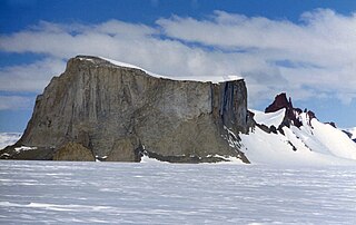
WSvarthamaren Mountain is a prominent ice-free mountain or large nunatak on the east side of the mouth of Vestreskorve Glacier in the Muhlig-Hofmann Mountains of Queen Maud Land, Antarctica. It was mapped from surveys and aerial photographs by the Norwegian Antarctic Expedition (1956–60) and named Svarthamaren.
WSvea Glacier is a broad glacier flowing north between the Sverdrup and Gjelsvik Mountains in Queen Maud Land. Photographed from the air by the German Antarctic Expedition (1938–39). Mapped by Norwegian cartographers from surveys and air photos by Norwegian-British-Swedish Antarctic Expedition (NBSAE) (1949–52) and air photos by the Norwegian expedition (1958–59) and named Sveabreen.
 W
WThe Svea Research Station is a Swedish research facility in Antarctica, established in 1987/1988.
WTerningen Peak is a small rock peak marking the summit of Terningskarvet Mountain in the Gjelsvik Mountains, Queen Maud Land. It was photographed from the air by the Third German Antarctic Expedition (1938–1939), led by Capt. Alfred Ritscher. It was mapped by Norwegian cartographers from surveys and air photos by the Norwegian-British-Swedish Antarctic Expedition (NBSAE) (1949–1952), led by John Schjelderup Giæver, and later by air photos by the Norwegian expedition (1958–59) and named Terningen.
WTønnesen Glacier is a broad glacier flowing north between Risemedet Mountain and Festninga Mountain, separating the Gjelsvik Mountains and the Mühlig-Hofmann Mountains in Queen Maud Land. It was mapped by Norwegian cartographers from surveys and air photos by the Norwegian Antarctic Expedition (1956–60) and named for J. Tønnesen, a meteorologist with the expedition.
WTverregg Glacier is a glacier between Heksegryta Peaks and Tverregga Spur in the Kirwan Escarpment, Queen Maud Land. Mapped by Norwegian cartographers from surveys and air photos by Norwegian-British-Swedish Antarctic Expedition (NBSAE) (1949–52) and additional air photos (1958–59), and named Tverreggbreen.
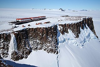
WVesleskarvet is a nunatak on the west side of Ahlmann Ridge located in Queen Maud Land, Antarctica. Its western side consists of a series of cliffs, approximately 250 m high, while the eastern side slopes more gradually down to the icefields. The accessibility of the relatively level wind-swept snow-free summit made it ideal for the establishment of the permanent South African National Antarctic Programme research base SANAE IV.
WThe Wasa Research Station is a Swedish research facility in Antarctica, established in 1988/1989. It is situated next to the Finnish Aboa Research Station on the Basen nunatak in the Kraul Mountains in Queen Maud Land. The two stations cooperate, and are jointly referred to as the Nordenskiöld Base Camp.