 W
WThe Āniwaniwa Falls, or Rainbow Falls, are a two-drop waterfall located at northeastern Lake Waikaremoana in New Zealand.
 W
WTe Motu-o-Kura / Bare Island is a small island located in the Pacific Ocean in the southern Hawke's Bay on the eastern shores of the North Island of New Zealand. It is located 2 kilometres (1.2 mi) off the North island coast, near Waimārama, 25 kilometres (16 mi) south of Cape Kidnappers.
 W
WBay View is a settlement in the Hawke's Bay region of the eastern North Island of New Zealand. It lies on State Highway 2, nine kilometres north of the city centre of Napier. The Esk River flows into the sea just to the north. Hawke's Bay Airport and the Napier suburb of Westshore lie just to the south. Bay View has been administered by the Napier City Council since the 1989 local government reforms.
 W
WClive is a small town, ten kilometres from the city centres of both Napier and Hastings in the Hawke's Bay region of New Zealand's North Island. It is close to the mouth of the Ngaruroro River.
 W
WThe more northerly of the two rivers called Esk River in New Zealand lies in Hawke's Bay, in the eastern North Island. One of the region's major rivers, it flows south from the slopes of Mount Taraponui in the Maungaharuru Range before turning east to reach Hawke Bay 10 kilometres (6 mi) north of Napier. State Highway 5 follows the lower course of the river for several kilometres close to the settlement of Eskdale. The river is probably named after the Esk River in southern Scotland and north-west England.
 W
WFlemington is a lightly populated locality in the Hawke's Bay region of New Zealand's North Island. It is located inland, south of Waipukurau and east of Ormondville. Nearby settlements include Whetukura to the west, Te Uri to the south-southwest, and Wanstead to the east.
WGreenmeadows is a suburb of the city of Napier, in the Hawke's Bay region of New Zealand's eastern North Island. In the 2013 New Zealand census, its population was 6,393, an increase of 183 from 2006. It was also part of the Taradale district council, borough and part of the Taradale ward.
 W
WThe Heretaunga Plains is a 300 square kilometres (120 sq mi) alluvial plain at the southern end of Hawke Bay on the east coast of the North Island of New Zealand. The towns of Napier, Hastings and Havelock North are on the plain.
 W
WKaweka Forest Park is in the Hawke's Bay region of New Zealand, adjacent to Kaimanawa Forest Park. This region of the central North Island contains large tracts of pine plantations, some of them also within the park, and as a consequence, invasive wilding conifers are present throughout the 594 km2 (229 sq mi) park.
 W
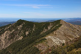
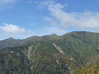
WThe Kaweka Range of mountains is located in inland Hawke's Bay in the eastern North Island of New Zealand. It forms part of the mountainous spine of the North Island which runs from Wellington to East Cape, including the Tararua and Ruahine ranges.
WKuripapango is a locality in the Hawke's Bay region of New Zealand, situated 76.6 km from Napier and 78.6 km from Taihape. It is on the Napier-Taihape Road more known as the Gentle Annie which rises to 3,200 feet (980 m) at its peak.
 W
WThe Mangatoro River or Mangatoro Stream is a river of the Hawke's Bay region of New Zealand. It runs northeast along the western edge of the Puketoi Range to reach the Mangamaire River south of Dannevirke.
 W
WThe Maraetotara River is a river of the Hawke's Bay region, New Zealand. It enters Hawke Bay at Te Awanga.
 W
WMeeanee is a suburb of the city of Napier, in the Hawke's Bay Region on the east coast of New Zealand's North Island. It was named after the Battle of Meeanee in India, won by Sir Charles Napier, the city's namesake. Along with such locations as Clive and Havelock North, it is one of several places within Hawke's Bay to be named for colonial Indian events or people.
WMohaka is a small settlement in the northern Hawke's Bay region of the eastern North Island of New Zealand. It is located on the coast of Hawke Bay, 20 kilometres southwest of Wairoa.
 W
WMokau Falls is a cascade located at the head of Mokau Inlet in New Zealand's Lake Waikaremoana.
 W
WNapier Hill is a limestone outcrop and suburb rising above the lowland districts of the city of Napier on New Zealand's North Island.
 W
WNapier Port is in Napier, New Zealand, on Hawke Bay. It is the North Island's second largest export port by tonnage, and is owned by the Port of Napier Ltd.
 W
WThe Ngaruroro River is located in the eastern North Island of New Zealand. It runs for a total of 164 kilometres southeast from the Kaweka Range, Kaimanawa Range and Ruahine Range and then east before emptying into Hawke Bay roughly halfway between the cities of Napier and Hastings, near the town of Clive. The river is mostly a single-thread channel down to Whanawhana, flowing through a greywacke rock gorge. Below Whanawhana, the river opens to wide braided channel and is joined by the Maraekakaho River. The Ngaruroro shares a river mouth with the Tutaekuri, Clive River and Muddy Creek. The meeting of these rivers forms the Waitangi Estuary.
WNuhaka is a small settlement in the northern Hawke's Bay Region of New Zealand's eastern North Island, lying on State Highway 2 between Wairoa and Gisborne.
WOingo Lake is one of several small lakes located northwest to the city of Hastings in the Hawke's Bay Region of the eastern North Island of New Zealand.
 W
WOngaonga is a village in Central Hawkes Bay District of New Zealand's North Island. It is located 20 kilometres west of Waipawa and a similar distance from Waipukurau.
 W
WOrmondville is a locality in the Hawke's Bay region of New Zealand's North Island. It is located inland, south of Waipukurau and west of Flemington, Hawke's Bay. It has a railway station.
WŌtāne is a town in the Central Hawke's Bay District and the Hawke's Bay region, on the east coast of New Zealand's North Island. The small village, has a school, general store, cafe and pub, and is located just off State Highway 2. The community had a population of 537 as of 2013.
WPōrangahau, a township close to the Pacific Ocean coast in the south-east of the North Island of New Zealand, has a very small population. It lies in the southernmost part of Hawke's Bay, 45 kilometres south of Waipukurau, and close to the mouth of the Porangahau River. There settlement includes a marae and a school.
 W
WPortland Island, also called Waikawa, is a small island off the southern tip of the Mahia Peninsula on the North Island of New Zealand. It is used for sheep farming.
 W
WPukehou is a farming locality in southern Hawke's Bay, in the eastern North Island of New Zealand.
WPutorino is a small farming settlement in northern Hawke's Bay, on the eastern side of New Zealand's North Island. It is located on State Highway 2 between Tutira and Mohaka, on the Hastings side of the border between Hastings and Wairoa.
 W
WThe Rangitaiki River is the longest river in the Bay of Plenty region in New Zealand's North Island. It is 155 kilometres (96 mi) long, and rises inland from northern Hawkes Bay to the east of the Kaingaroa Forest. The Rangitaiki catchment covers an area of 3005 km2. It flows in a generally northeastward direction, passing through the town of Murupara and skirting close to the western edge of Te Urewera National Park before turning northwards, flowing past Edgecumbe and into the Bay of Plenty close to Thornton.
 W
WThe Ruahine Range is the largest of several mountain ranges in the North Island of New Zealand that form a ridge running parallel with the east coast of the island between East Cape and Wellington. The ridge is at its most pronounced from the central North Island down to Wellington, where it comprises the Ruahine, Tararua and Remutaka Ranges.
WRunanga Lake is one of several small lakes located to the northwest of the city of Hastings in the Hawke's Bay Region of the eastern North Island of New Zealand. Water from the lake flows into the Ngaruroro River.
WTakapau is a small rural community in the Central Hawkes Bay in New Zealand. It is located 20 kilometres west of Waipukurau, off State Highway 2, and has a population of more than 500.
WTe Haroto is a rural community in the Hastings District and Hawke's Bay Region of New Zealand's North Island.
 W
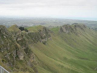
WTe Mata Peak is a peak south of Hastings rising up to 399m in the Te Mata Hills in the Hawke's Bay region of New Zealand. A sealed road leads to the popular lookout at the summit, as well as several trails for hikers and mountain bikers. The Hastings suburb of Havelock North is built on the slopes of the peak.
WTe Pōhue is a small settlement in inland Hawke's Bay, in New Zealand's eastern North Island. It lies on State Highway 5, 31 kilometres inland from Whirinaki.
WTikokino is a town in the Central Hawke's Bay District on the east coast of the North Island of New Zealand. It is located 20 kilometres (12 mi) northwest of Waipawa and 55 kilometres (34 mi) southwest of Hastings. The township is located on State Highway 50.
 W
WThe Tukituki River is found in the eastern North Island of New Zealand. It flows from the Ruahine Ranges to the Pacific Ocean at the southern end of Hawke's Bay.
 W
WThe Tūtaekurī River flows through the Hawke's Bay Region of the eastern North Island of New Zealand. It flows east from the Kaweka Range, reaching the Pacific Ocean just to the south of Napier and Taradale, where the Ngaruroro and Clive Rivers join it. Starting roughly 50 kilometers north east of Taihape, the Tūtaekurī River flows for a distance of 99.9 kilometers.
WLake Waikareiti, also spelt Lake Waikare Iti, is located in Te Urewera National Park in the North Island of New Zealand. A number of hiking trails are found within the catchment basin of the lake.
 W
WThe Waikaretāheke River is a river of the Hawke's Bay region of New Zealand's North Island. It serves as the outflow of Lake Waikaremoana, flowing southeast from the lake's southeastern shore to reach the Waiau River 20 kilometres northwest of Wairoa. State Highway 38 follows the river's course for much of its length.
 W
WWaimārama is a seaside village in Hastings District, Hawke's Bay, New Zealand.
WWaipawa is the second-largest town in Central Hawke's Bay in the east of the North Island of New Zealand. It has a population of 2,250. At the 2013 census, it had a population of 1,965, a change of 2.2 percent from the 2006 census.
 W
WThe Waipunga River is a tributary of the Mohaka River, located between Taupo and Napier in New Zealand's North Island. It runs roughly 50 km from its source near the eastern edge of the Volcanic Plateau to its junction with the Mohaka, of which some 15 km follow alongside the Napier-Taupo highway.
WWhirinaki is a small settlement in the northern Hawke's Bay Region of New Zealand's eastern North Island. It lies close to the junction of State Highways 2 and 5, and is most notable as the location of Pan Pac Mill, one of Hawke's Bay's largest industrial plants.