 W
WAagaard Glacier, also known as Glaciar Alderete, is an 8-mile (13 km) long Antarctic glacier which lies close to the east of Gould Glacier and flows in a southerly direction into Mill Inlet, on the east coast of Graham Land. It was charted by the Falkland Islands Dependencies Survey (FIDS) and photographed from the air by the Ronne Antarctic Research Expedition during December 1947; it was named by the FIDS for Bjarne Aagaard, a Norwegian authority on Antarctic whaling and exploration.
 W
WAlberts Glacier is a heavily crevassed glacier in Antarctica. It is about 8 miles (13 km) long, and flows east from Avery Plateau, Graham Land, until entering Mill Inlet between Balch Glacier and Southard Promontory.
 W
WCape Alexander is a cape which forms the south end of Churchill Peninsula and the east side of the entrance to Cabinet Inlet, on the east coast of Graham Land. It was charted by the Falkland Islands Dependencies Survey (FIDS) and photographed from the air by the Ronne Antarctic Research Expedition (RARE) in December 1947.
WAnderson Glacier is a heavily crevassed glacier 12 nautical miles (22 km) long, flowing southeast into Cabinet Inlet between Cape Casey and Balder Point, on the east coast of Graham Land.
WAttlee Glacier is a glacier 8 miles (13 km) long, which flows east-southeast from the plateau escarpment on the east side of Graham Land to the head of Cabinet Inlet to the north of Bevin Glacier.
WAvery Plateau is an ice-covered plateau, about 40 miles (64 km) long and rising to about 2,000 metres (6,600 ft), midway between Loubet Coast and Foyn Coast in Graham Land, Antarctica. It borders Hemimont Plateau on the south and Bruce Plateau on the north. The first sighting of this plateau is not certain, but it was presumably seen in January and February 1909 by members of the French Antarctic Expedition under Jean-Baptiste Charcot from various positions in the Matha Strait. It was surveyed in 1946–47 by the Falkland Islands Dependencies Survey, and named by the UK Antarctic Place-Names Committee (1955) after Captain George Avery, master of the cutter Lively, who, with Captain John Biscoe in the brig Tula, approached this part of the Antarctic Peninsula in February 1832.
 W
WBalabanski Crag is the rocky peak rising to 600 m in eastern Bigla Ridge on Heros Peninsula, Foyn Coast on the Antarctic Peninsula. It surmounts Cabinet Inlet to the northeast.
WBalch Glacier is a glacier 9 nautical miles (17 km) long, on the east coast of Graham Land, flowing southeast into Mill Inlet, to the south of Gould Glacier.
WBalder Point is a headland in Antarctica marking the eastern tip of a narrow, rocky "cockscomb" ridge, which extends from Frigga Peak for 6 nautical miles (11 km) in an east-southeast direction to the west side of Cabinet Inlet, on the east coast of Graham Land. It was charted in 1947 by the Falkland Islands Dependencies Survey, who named it after the Norse god Balder, the mythological son of Frigga and Odin.
WBeaglehole Glacier is a glacier between Spur Point and Friederichsen Glacier on the east coast of Graham Land. It was named by the UK Antarctic Place-Names Committee after John Cawte Beaglehole, New Zealand historian of the Antarctic and biographer of Captain James Cook.
WBevin Glacier is a glacier 5 nautical miles (9 km) long, which flows east from the plateau escarpment on the east side of Graham Land into the northwest end of Cabinet Inlet between Attlee Glacier and Anderson Glacier. During December 1947 it was charted by the Falkland Islands Dependencies Survey (FIDS) and photographed from the air by the Ronne Antarctic Research Expedition. It was named by the FIDS for Rt. Hon. Ernest Bevin, M.P., British Minister of Labour and National Service and member of the War Cabinet.
WBigla Ridge is the rocky, partly ice-free ridge extending 19 km in northwest-southeast direction, 8.8 km wide and rising to 850 m on Foyn Coast, Antarctic Peninsula. The ridge is crescent-shaped facing southwest and surmounting Sleipnir Glacier to the northwest and Beaglehole Glacier to the southwest, with its southeast half forming Heros Peninsula.
WBiolchev Peak is the rocky peak rising to 550 m in eastern Bigla Ridge on Heros Peninsula, Foyn Coast on the Antarctic Peninsula. It surmounts Beaglehole Glacier to the west.
WBreitfuss Glacier is a glacier 10 nautical miles (19 km) long, which flows southeast from Avery Plateau into Mill Inlet to the west of Cape Chavanne, on the east coast of Graham Land. It was charted by the Falkland Islands Dependencies Survey (FIDS) and photographed from the air by the Ronne Antarctic Research Expedition in 1947. It was named by the FIDS for Leonid Breitfuss, a German polar explorer, historian, and author of many polar bibliographies.
WChemish Ridge is the rocky ridge extending 8.55 km in west-northwest to east-southeast direction, 2 km wide and rising to 600 m on Foyn Coast, Antarctic Peninsula. The ridge surmounts Attlee Glacier to the north and Bevin Glacier to the south, with its east extremity forming Fitzmaurice Point.
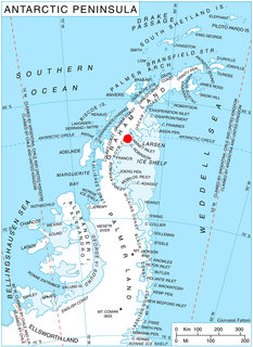
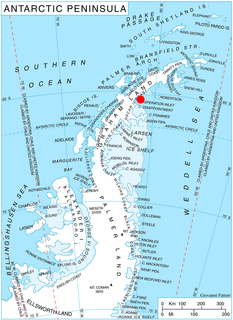
WChurchill Peninsula is an ice-covered peninsula between Cabinet Inlet and Adie Inlet, extending some 30 miles (50 km) in a southeasterly direction from the east coast of Graham Land. The peninsula ends in Cape Alexander separating Oscar II Coast to the northeast from Foyn Coast to the southwest, and has its east coast indented by Zimen Inlet and Brentopara Inlet.
WChuypetlovo Knoll is the conspicuous rocky ridge in Beaglehole Glacier extending 3.7 km in southeast-northwest direction, 1.9 km wide and rising to 700 m southwest of Bigla Ridge on Foyn Coast, Antarctic Peninsula.
WCole Peninsula is a peninsula, 24 kilometers long in an east-west direction and 13 kilometers wide, lying between Cabinet Inlet and Mill Inlet on the east coast of Graham Land, just east of Thuronyi Bluff and immediately north of the Antarctic Circle. The peninsula is surrounded by the Larsen Ice Shelf, which is part of the Weddell Sea.
WMount Dater is a prominent flat-topped coastal mountain which is marked by distinctive rock spurs and steep cliffs, rising to 1,200 metres (3,900 ft) south of Mill Inlet on the Foyn Coast of Graham Land. The feature was roughly surveyed by the Falkland Islands Dependencies Survey in 1947, and it was photographed from the air by the Ronne Antarctic Research Expedition, in 1947, and the U.S. Navy in 1963. Following surveys were completed by the British Antarctic Survey in 1963–64. In association with the names of Antarctic historians grouped in this area, it was named by the UK Antarctic Place-Names Committee after Henry M. Dater (1909–74), a U.S. Navy Historian who was a member of the U.S. Advisory Committee on Antarctic Names from 1962–72 and the chairman during 1973–74. He was also co-author of Antarctica, Zurich, 1959.
 W
WDemorest Glacier is a glacier on the northeast side of Hemimont Plateau which flows southeast into Whirlwind Inlet between Flint Glacier and Matthes Glacier, on the east coast of Graham Land. It was discovered by Sir Hubert Wilkins on a flight of December 20, 1928, and photographed from the air by the United States Antarctic Service in 1940. It was charted by the Falkland Islands Dependencies Survey in 1947 and named for Max H. Demorest, an American glaciologist.
WMount Denucé is a rounded mountain, 1,535 metres (5,040 ft) high, between Mount Hulth and Mount Haskell on the southwest side of Cabinet Inlet, on the east coast of Graham Land. It was charted by the Falkland Islands Dependencies Survey (FIDS) and photographed from the air by the Ronne Antarctic Research Expedition in December 1947. It was named by the FIDS for Jean Denucé, a Belgian polar bibliographer.
WFitzmaurice Point is a point on the northwest side of Cabinet Inlet, Foyn Coast, Antarctica, between Attlee Glacier and Bevin Glacier. It was photographed from the air by the Ronne Antarctic Research Expedition and surveyed from the ground by the Falkland Islands Dependencies Survey in December 1947. It was named in 1985 by the UK Antarctic Place-Names Committee (UK-APC) after Sir Gerald G. Fitzmaurice, Legal Advisor at the Foreign Office, 1953–60, who served some of the Cabinet Ministers commemorated in this area. Fitzmaurice was chairman of the UK-APC, 1952–60.
WThe Foyn Coast is that portion of the east coast of the Antarctic Peninsula between Cape Alexander and Cape Northrop. It was discovered in 1893 by a Norwegian expedition under Captain Carl Anton Larsen, who named it for Svend Foyn, a Norwegian whaler of Tønsberg whose invention of the grenade harpoon greatly facilitated modern whaling.
 W
WFoyn Point is a point surmounted by a peak 525 metres (1,720 ft) high, forming the southeast extremity of Blagoevgrad Peninsula and marking the north side of the entrance to Exasperation Inlet, on Oscar II Coast on the east side of Graham Land, Antarctica. Sir Hubert Wilkins on a flight of December 20, 1928 photographed what appeared to be an island off the east coast, later charting it in 66°30′S 62°30′W. Subsequent comparison of Wilkins' photographs of this feature with those taken by the Falkland Islands Dependencies Survey, who charted the coast in 1947, indicate that this point, although considerably north of the position reported by Wilkins, is the feature named by him as "Foyn Island". The name Foyn Point is given to the southeast extremity of this feature. It is named for Svend Foyn.
WFrigga Peak is a peak, 1,570 metres (5,150 ft) high, which stands at the south side of Anderson Glacier on the east coast of Graham Land, Antarctica. It was charted by the Falkland Islands Dependencies Survey (FIDS) and photographed from the air by the Ronne Antarctic Research Expedition in 1947. The FIDS named it after the Norse goddess Frigga, the "cloud spinner," because clouds were observed to form on the summit of this peak earlier than on any other feature in this vicinity. Nearby Mount Odin was named in association, since Odin is Frigga's wife in Norse mythology.
WGluhar Hill is the ice-covered hill rising to 650 m in Bevin Glacier on Foyn Coast, Antarctic Peninsula.
WHeros Peninsula is the partly ice-free 8.9 km wide peninsula projecting from Foyn Coast, Antarctic Peninsula 13 km southeastwards into Cabinet Inlet. It ends in Spur Point to the southeast.
WKoledari Knoll is the rocky ridge extending 1 km in north-northwest to south-southeast direction, 320 m wide, and rising to 350 m on Foyn Coast in Graham Land. It is situated in the north part of Churchill Peninsula, overlooking Adie Inlet to the northeast and Scar Inlet to the southwest. The feature is named after the Bulgarian folkloric ritual of ‘Koledari.’
WMeda Nunatak is the rocky ridge extending 2.65 km in west-northwest to east-southeast direction, 700 m wide and rising to 770 m in Attlee Glacier on Foyn Coast, Antarctic Peninsula.
WMitterling Glacier is a glacier on the east coast of Graham Land, Antarctica, draining between Mount Vartdal and Mount Hayes into the northern part of Mill Inlet. It was named by the UK Antarctic Place-Names Committee after American historian Philip I. Mitterling, the author of America in the Antarctic to 1840.
WMount Mecheva is the broad ice-covered peak with precipitous rocky north, east and southwest slopes that peaks at 850 m in the Bigla Ridge on Foyn Coast, Antarctic Peninsula. It surmounts Beaglehole Glacier to the southwest, Sleipnir Glacier to the northwest and Cabinet Inlet to the northeast.
WMount Odin is a saddle-top mountain on the Foyn Coast of Graham Land, Antarctica. It consists of two ice-covered peaks and stands 1,465 m (4,806 ft) tall. It is situated close to Frigga Peak to the southwest, on the divide between Anderson Glacier and Sleipnir Glacier. In 1947, the peak was photographed from the air by the Ronne Antarctic Research Expedition (RARE) and charted from the ground by the Falklands Islands Dependencies Survey (FIDS). It was named by FIDS personnel after the Norse god Odin, the mythological husband of Frigga.
WMount Popov is the broad ice-covered peak with precipitous rocky slopes rising to 650 m in eastern Bigla Ridge on Heros Peninsula, Foyn Coast on the Antarctic Peninsula. It surmounts Beaglehole Glacier to the west and Cabinet Inlet to the northeast.
WCape Robinson is a cape marking the east end of Cole Peninsula, between Cabinet and Mill Inlets on Foyn Coast, Graham Land. Sir Hubert Wilkins, while on his flight of December 20, 1928 along this coast, named an island for W.S. Robinson of London and Australia, which he reported to lie in about 67°20′S 61°40′W. Absence of photographs of this island by Wilkins has prevented its positive reidentification. For this reason, and for the sake of historical continuity, it is recommended that the east end of the peninsula here described be given the name Cape Robinson. This cape was charted by the Falkland Islands Dependencies Survey (FIDS) and photographed from the air by the Ronne Antarctic Research Expedition (RARE) in 1947.
WRoscoe Promontory is a massive ice-capped promontory between Aagaard Glacier and Mitterling Glacier on the north side of Mill Inlet, Foyn Coast, Graham Land. The feature was photographed by Ronne Antarctic Research Expedition (RARE) and surveyed by Falkland Islands Dependencies Survey (FIDS) in 1947. Named by Advisory Committee on Antarctic Names (US-ACAN) in 1987 after John H. Roscoe, photogrammetrist on U.S. Navy Operation Highjump, 1946–47, and Operation Windmill, 1947–48; author of Antarctic Bibliography, U.S. Naval Photographic Interpretation Center, Department of the Navy, 1951, and Antarctica, Regional Photo Interpretation Series, Department of the Air Force, 1953. The promontory is in proximity to several features named after Antarctic bibliographers.
WSleipnir Glacier is a glacier 10 nautical miles (18 km) long, flowing into the west side of Cabinet Inlet between Balder and Spur Points, on the east coast of Graham Land, Antarctica. Vologes Ridge is situated in the central portion of the glacier.
WSouthard Promontory is a notable promontory, 6 nautical miles long and 2 nautical miles wide, which juts into northwest Mill Inlet between Breitfuss Glacier and Alberts Glacier, on the Foyn Coast, Graham Land. The promontory is bordered by steep rock cliffs which rise 1,500 metres (4,900 ft) to a relatively flat and snow covered upper surface. It was photographed from the air by Ronne Antarctic Research Expedition (RARE) and surveyed from the ground by Falkland Islands Dependencies Survey (FIDS) in 1947. In association with the names of Antarctic cartographers grouped in this area, named by the United Kingdom Antarctic Place-Names Committee (UK-APC) after Rupert B. Southard, Jr., Chief, National Mapping Division, United States Geological Survey (USGS), 1979–86; Chief, Office of International Activities, 1961–64; U.S. Representative to the SCAR Working Group on Geodesy and Cartography, 1964–79; Chairman, Domestic Names Committee of the USBGN, 1983-87.
WSpur Point is a point at the east end of Bigla Ridge, a black, rocky spur which extends southeast between Sleipnir Glacier and Beaglehole Glacier to the west side of Cabinet Inlet, forming the southeast extremity of Heros Peninsula on the east coast of Graham Land. This descriptive name was given by the Falkland Islands Dependencies Survey (FIDS) following their survey in 1947. The feature was photographed from the air during 1947 by the Ronne Antarctic Research Expedition (RARE) under Ronne.
WStancheva Peak is an ice-covered peak that forms the west extremity of Bigla Ridge on Foyn Coast, Antarctic Peninsula. It rises to 850 m and has precipitous rocky northwest, southeast and southwest slopes. It surmounts Sleipnir Glacier to the north and Beaglehole Glacier to the south.
WStanley Island is a 3.2 km (2 mi) long and 520 m high island off Heros Peninsula on Foyn Coast, Antarctica. It lies in the western part of Cabinet Inlet, 8 km (5 mi) northeast of Spur Point and 6 km (4 mi) east of Balabanski Crag.
WTakev Point is the rocky point forming the south extremity of Heros Peninsula on Foyn Coast, Antarctic Peninsula.
WVarad Point is the rocky point on Foyn Coast, Antarctic Peninsula situated 12.8 km west-southwest of Spur Point and 33.6 km north-northwest of Cape Robinson.
WMount Vartdal is a 1,505 m tall snow-capped peak surmounting and forming part of the plateau escarpment along the east coast of Graham Land. It is situated 4 nautical miles (7 km) northeast of Karpf Point on the north side of Mill Inlet. It was charted by the Falkland Islands Dependencies Survey (FIDS) in 1947 and named for Hroar Vartdal, a Norwegian polar bibliographer. This feature was photographed from the air during 1947 by the Ronne Antarctic Research Expedition (RARE) under Ronne.
WVologes Ridge is the ice-covered flat-topped ridge extending 5.85 km in east-west direction, 1.55 km wide and rising to 700 m in central Sleipnir Glacier on Foyn Coast, Antarctic Peninsula.
WZabergan Peak is the rocky peak rising to 700 m on Foyn Coast, Antarctic Peninsula, and surmounting Beaglehole Glacier to the northeast and Friederichsen Glacier to the southwest.