 W
WAchada Monte is a town in the northern part of the island of Santiago, Cape Verde and is part of the municipality of São Miguel. It is situated near the east coast, 8 km northwest of Calheta de São Miguel. In 2010 its population was 1,652. It is on the road connecting Praia and Tarrafal through Pedra Badejo, the EN1-ST02. The small bay Mangue de Sete Ribeiras is located east of the settlement. Ribeira Principal flows west of the village.
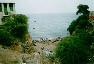
WAchada Tenda is a town in the northern part of the island of Santiago, Cape Verde. In 2010 its population was 1,242. It is situated on the east coast, 10 km southeast of Tarrafal. The small bay Porto Formoso is situated near the town.
 W
WAssomada is a city on the Sotavento (leeward) island of Santiago in Cape Verde. Since 1912, it is the seat of the municipality of Santa Catarina, which comprises the central western part and much of the interior of the island. It is the largest city in that region.
 W
WBaía do Inferno is a bay on the southwest coast of the island of Santiago in Cape Verde in the Atlantic Ocean. The bay is completely within the municipality of Santa Catarina. It is a large and relatively sheltered bay, characterised by steep cliffs, more than 400 m high in some places. The nearest settlement is Entre Picos de Reda, 3 km inland. Rincão lies 4 km north along the coast, Porto Mosquito 6 km southeast.
WPonta Bicuda is a headland in the northern part of the island of Santiago, Cape Verde. It is 3 km (1.9 mi) east of Ponta Moreia, the northernmost point of Santiago, and 8 kilometres (5.0 mi) northeast of Tarrafal. In the 1747 map by Jacques-Nicolas Bellin, the point was mentioned as "Pt. Bikkude".
WPonta das Bicudas is a headland in the southeastern part of the island of Santiago, Cape Verde. It is 3 km east of the city centre of Praia, near the neighbourhood Achada Grande Tras. The Praia Harbour lies west of the headland.
 W
WCalheta de São Miguel is a city in the northern part of the island of Santiago, Cape Verde. In 2010 its population was 3,175. It is on the east coast, 31 km (19 mi) north of the capital Praia. It is the seat of São Miguel municipality.
WChã de Tanque is a town in the west-central part of the island of Santiago, Cape Verde. It is part of the municipality of Santa Catarina. In 2010 its population was 1,164. It is situated 4 km west of Assomada, on the road to Rincão. The elevation is about 260 meters above sea level. Since 2008, it is home to the Museu da Tabanca.
 W
WCidade Velha is a city in the southern part of the island of Santiago, Cape Verde. Founded in 1462, it is the oldest settlement in Cape Verde and its former capital. Once called Ribeira Grande, its name was changed to Cidade Velha in the late 18th century. It is the seat of the Ribeira Grande de Santiago municipality.
 W
WMonte Graciosa is a mountain in the northern part of the island of Santiago in Cape Verde. It lies 2.5 km north of the town of Tarrafal, overlooking the Baía de Tarrafal. Its elevation is 643 m. Towards the west it ends in the headland of Ponta Preta. It is part of a larger proposed natural park. The mountain is of volcanic origin, composed of phonolite and rich in feldspar and olivine.
 W
WRibeira Grande de Santiago is a stream in the southern part of the island of Santiago in Cape Verde. In its upper part it is called Ribeira Cadacina. Its source is in the central mountain range of the island, near Monte Tchota, west of Rui Vaz, in the municipality of São Domingos. It flows towards the south, and joins the Atlantic Ocean in Cidade Velha. Villages along its course are Achada Loura, Salineiro and Calabaceira. A reservoir for irrigation was built near Salineiro in 2013.
 W
WJoão Teves is a city in the central part of the island of Santiago, Cape Verde. It is situated 19 km northwest of the capital Praia, on the national road from Praia to Assomada (EN1-ST01). It is the seat of São Lourenço dos Órgãos municipality. A source river of the Ribeira Seca flows through the town.
WPonta do Lobo is a headland in the southeastern part of the island of Santiago, Cape Verde. It is in the municipality of São Domingos, 4 km east of Vale da Custa, 4 km southeast of Moia Moia and 11 km northeast of Praia. The nearby bay Porto Lobo was mentioned as P. Lobo on the 1747 map by Jacques-Nicolas Bellin. The Ponta do Lobo Lighthouse stands on the headland.
 W
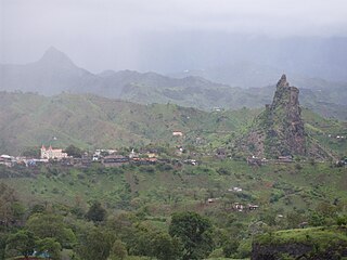
WMonte Tchota is a mountain located in the central part of Santiago Island in Cape Verde. Its elevation is 1,041 m. It is part of the Serra do Pico de Antónia Natural Park, and lies 1.5 km southeast of Pico de Antónia, the highest point of the island. The village Rui Vaz lies 3 km to the east.
 W
WPonta Moreia is the northernmost point of the island of Santiago, Cape Verde. It is about 2 km north of the nearest village, Fazenda, and around 5 km north of Tarrafal.
 W
WPedra Badejo is a city in the eastern part of the island of Santiago, Cape Verde. It is on the east coast, 25 km (16 mi) north of the island capital Praia, 8 km (5.0 mi) southeast of Calheta de São Miguel and 15 km (9.3 mi) east of Assomada. It is the seat of Santa Cruz municipality. At the 2010 census, the town had 9,859 inhabitants.
 W
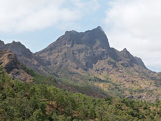
WPico de Antónia is a mountain located in the central part of the island of Santiago in Cape Verde. At 1,392 m (4,567 ft), it is the highest point of the island. The mountain is part of the protected area Parque Natural da Serra do Pico de Antónia. The towns Picos and Assomada lie close to the mountain. The Serra do Pico da Antónia has been identified by BirdLife International as an Important Bird Area.
 W
WPicos, also known as Achada Igreja, is a city in the central part of the island of Santiago, Cape Verde. It is the seat of São Salvador do Mundo municipality. Picos is located 4 km southeast of Assomada and 23 km northwest of the capital city of Praia, near the national road from Praia to Tarrafal via Assomada (EN1-ST01).
 W
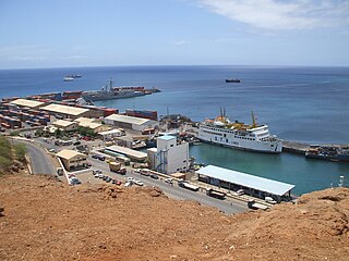
WPraia Harbor is the port of the city of Praia in the southern part of the island of Santiago, Cape Verde. It is situated in a natural bay of the Atlantic Ocean. Since the latest modernization in 2014, it has 2 long quays, 3 shorter quays, a quay for fishing boats with fish processing installations, 2 container parks, 2 roll-on/roll-off ramps and a passenger terminal. The total length of the quays is 863 m, and the maximum depth is 13.5 m. The port of Praia played an important role in the colonization of Africa and South America by the Portuguese. With 817,845 metric tonnes of cargo and 85,518 passengers handled (2017), it is the second busiest port of Cape Verde, after Porto Grande (Mindelo).
WPraia Harbor is the port of the city of Praia in the southern part of the island of Santiago, Cape Verde. It is situated in a natural bay of the Atlantic Ocean. Since the latest modernization in 2014, it has 2 long quays, 3 shorter quays, a quay for fishing boats with fish processing installations, 2 container parks, 2 roll-on/roll-off ramps and a passenger terminal. The total length of the quays is 863 m, and the maximum depth is 13.5 m. The port of Praia played an important role in the colonization of Africa and South America by the Portuguese. With 817,845 metric tonnes of cargo and 85,518 passengers handled (2017), it is the second busiest port of Cape Verde, after Porto Grande (Mindelo).
 W
WPonta Preta is a headland in the northwest of the island of Santiago, Cape Verde. It is about 3 km northwest of the town of Tarrafal, and marks the northwestern limit of Baía de Tarrafal. There is a lighthouse on the headland, Farol da Ponta Preta.
 W
WRibeira Principal is a stream in the northern part of the island of Santiago, Cape Verde. It flows completely within the municipality of São Miguel. Its source is in the Serra Malagueta mountains. It flows generally north, through the valley of Principal, and joins the Atlantic Ocean near Achada Monte.
 W
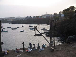
WRibeira da Barca is a town in the municipality of Santa Catarina, on the island of Santiago, Cape Verde. In 2010 its population was 2,317. It is situated on the west coast, at the mouth of the stream Ribeira da Barca, 11 km northwest of Assomada. The settlement was mentioned as "Rivera das Baras" in the 1747 map by Jacques-Nicolas Bellin.
WCharco is a settlement in the west of the island of Santiago, Cape Verde. It is part of the municipality of Santa Catarina. It lies 2.5 km southeast of Ribeira da Barca and 9 km west of the municipal seat Assomada. In 2010 its population was 266.
 W
WRibeira Grande de Santiago is a concelho (municipality) of Cape Verde. It is situated in the southwestern part of the island of Santiago. Its seat is the city Cidade Velha. Its population was 8,325 at the 2010 census, and its area is 137.3 km².
WRibeira da Prata is a town in the northern part of the island of Santiago, Cape Verde belonging to the municipality of Tarrafal. In 2010 its population was 1,009. It was mentioned as Rivera de Prata in the 1747 map by Jacques-Nicolas Bellin.
 W
WSanta Catarina is a concelho (municipality) of Cape Verde. It is situated in the western part of the island of Santiago. Its seat is the city of Assomada. Its population was 45,920 in 2017 (estimate). Its area is 242.6 km2 (93.7 sq mi).
 W
WSanta Cruz is a concelho (municipality) of Cape Verde. It is situated in the eastern part of the island of Santiago. Its seat is the city Pedra Badejo. Its population was 26,617 at the 2010 census, and its area is 112.2 km2.
WSantíssimo Nome de Jesus is a freguesia of Cape Verde. It covers the eastern part of the municipality of Ribeira Grande de Santiago, on the island of Santiago.
 W
WSão Domingos is a concelho (municipality) of Cape Verde. It is situated in the southeastern part of the island of Santiago. Its seat is the city São Domingos. Its population was 13,699 at the 2010 census, and its area is 147.5 km2.
 W
WSão Domingos is a city in the central part of the island of Santiago, Cape Verde. In 2010 its population was 2,818. It is the seat of the São Domingos Municipality. It is situated 13 km southeast of Assomada and 13 km northwest of the capital Praia, along the national road from Praia to Assomada (EN1-ST01). The settlement appeared in the 1747 map by Jacques-Nicolas Bellin as St. Domingo.
WSão João Baptista is a freguesia of Cape Verde. It covers the western part of the municipality of Ribeira Grande de Santiago, on the island of Santiago.
WBaía de São Jorge is a bay of the Atlantic Ocean on the south coast of the island of São Nicolau in Cape Verde. The only important settlement on the bay is the port village of Preguiça.
 W
WSão Lourenço dos Órgãos is a concelho (municipality) of Cape Verde. It is situated in the mountainous central part of the island of Santiago. Its seat is the city João Teves. Its population was 7,388 at the 2010 census, and its area is 36.9 km2. The municipality is bordered by Santa Cruz to the northeast, São Domingos to the south, Ribeira Grande de Santiago to the southwest and São Salvador do Mundo to the northwest. Pico de Antónia, the island's highest mountain, straddles the borders of São Lourenço dos Órgãos, São Salvador do Mundo and Ribeira Grande de Santiago.
 W
WSão Miguel is a concelho (municipality) of Cape Verde. It is situated in the northeastern part of the island of Santiago. Its seat is the city Calheta de São Miguel. Its population was 15,648 at the 2010 census, and its area is 77.4 km2. The municipality was created in 1996, when a parish of the older Municipality of Tarrafal was separated to become the Municipality of São Miguel.
 W
WSão Salvador do Mundo is a concelho (municipality) of Cape Verde. It is situated in the central part of the island of Santiago. Its seat is the city Picos. Its population was 8,677 at the 2010 census, and its area is 26.5 km2, making it the smallest municipality of Cape Verde. The municipality borders Santa Cruz to the northeast, São Lourenço dos Órgãos to the southeast, Ribeira Grande de Santiago to the southwest and Santa Catarina to the northwest.
 W
WRibeira Seca is the largest stream of the island of Santiago in Cape Verde. It is 18 km (11 mi) long and its basin area is 71.5 km2 (27.6 sq mi). Located in the eastern part of the island, it flows through the municipalities of São Lourenço dos Órgãos and Santa Cruz. Its source is near the highest point of the island, Pico de Antónia, from where it flows to the east to João Teves. It turns to the northeast and flows into the Atlantic Ocean at Achada Fazenda, 2 km southeast of Pedra Badejo. It is called Ribeira de Pico da Antónia in its uppermost part, and Ribeira de Lage near João Teves.
 W
WThe Serra do Pico de Antónia is a mountain range in the centre of the island of Santiago in the Cape Verde archipelago. It contains the Pico de Antónia, at 1,392 m (4,567 ft) the highest point of the island. It is protected as a natural park,, covering 28.73 km2 (11.09 sq mi). The natural park covers the connected mountain ranges of Serra do Pico de Antónia and of Rui Vaz.
 W
WSerra Malagueta is a mountain range located in the northern part of the island of Santiago, Cape Verde. At 1064 m elevation, it is highest point of northern Santiago. The mountain range is protected as the Serra Malagueta Natural Park, that was established on February 24, 2005 and covers 774 hectares. The natural park is situated in the municipalities Tarrafal, São Miguel and Santa Catarina. The summit is in São Miguel, south of the Ribeira Principal valley. The Serra Malagueta formation is of volcanic origin, and was formed between 2.9 and 2.4 million years ago.
 W
WBaía de Tarrafal or Tarrafal Bay is a bay of the Atlantic Ocean on the northwest coast of the island of Santiago in Cape Verde. The town of Tarrafal lies at its southeastern shore, and 643 m high Monte Graciosa rises from its northern shore. Most of its coast is rocky, but there is a stretch of beach near the city. The headland Ponta Preta marks the northwestern limit of the bay; there is a lighthouse on it.
 W
WTarrafal is a city in the northern part of the island of Santiago, Cape Verde. In 2010 its population was 6,656. It is a fishing port situated on the northwestern coast. It constitutes the seat of the Tarrafal Municipality.
 W
WTarrafal is a concelho (municipality) of Cape Verde. It is situated in the northern part of the island of Santiago. Its seat is the town Tarrafal. Its population was 18,565 at the 2010 census, and its area is 120.8 km2.
 W
WPonta Temerosa is a headland on the island of Santiago, Cape Verde. Located in the south of the capital Praia, it is the southernmost point of the island. It is 2 km south from the city center. The lighthouse Farol de D. Maria Pia stands at the eastern point of the headland, marking the entrance to the Praia Harbour.
 W
WRibeira da Trindade is a stream in the southern part of the island of Santiago in Cape Verde. It is the most important river of Praia, the capital of Cape Verde. Its basin area is 24.9 km2 (9.6 sq mi). The stream flows northwest to southeast and is about 15 km in length. Its source is in the municipality of São Domingos, near the settlement Achada Mitra. It flows through the city of Praia and discharges into the Praia Harbour, near the city centre.
WMonte das Vacas is a mountain located in the southeastern part of the island of Santiago, Cape Verde. It is 2 km south of Ribeirão Chiqueiro and 8 km of the city centre of the capital Praia. Its elevation is 437 meters. It is of volcanic origin and was formed between 1.1 and 0.7 million years ago.