 W
WThe Aarmassif or Aaremassif is a geologic massif in the Swiss Alps. It contains a number of large mountain chains and parts of mountain chains.
WThe Adriatic or Apulian Plate is a small tectonic plate carrying primarily continental crust that broke away from the African plate along a large transform fault in the Cretaceous period. The name Adriatic Plate is usually used when referring to the northern part of the plate. This part of the plate was deformed during the Alpine orogeny, when the Adriatic/Apulian Plate collided with the Eurasian plate.
 W
WThe Alpine orogeny or Alpide orogeny is an orogenic phase in the Late Mesozoic (Eoalpine) and the current Cenozoic that has formed the mountain ranges of the Alpide belt. These mountains include the Atlas, the Rif, the Baetic Cordillera, the Cantabrian Mountains, the Pyrenees, the Alps, the Apennine Mountains, the Dinaric Alps, the Pindus (Hellenides), the Carpathians, the Balkanides - Balkan Mountains and Rila-Rhodope massifs, the Pontic Mountains, the Taurus, the Armenian Highlands, the Caucasus, the Alborz, the Zagros, the Hindu Kush, the Pamir, the Karakoram, and the Himalayas. Sometimes other names occur to describe the formation of separate mountain ranges: for example Carpathian orogeny for the Carpathians, Hellenic orogeny for the Pindus, Altai orogeny for Altai Mountains or the Himalayan orogeny for the Himalayas.
 W
WThe Couches de l’Aroley are a sedimentary formation deposited during the Early Cretaceous. They consist of calcitic schists with dolomite clasts interbedded with finegrained conglomerates. The whole sequence is about 100 m thick.
WThe Austroalpine nappes are a geological nappe stack in the European Alps. The Alps contain three such stacks, of which the Austroalpine nappes are structurally on top of the other two. The name Austroalpine means Southern Alpine, because these nappes crop out mainly in the Eastern Alps.
 W
WThe Besano Formation is a geological formation in the southern Alps of northwestern Italy and southern Switzerland. This formation, a short but fossiliferous succession of dolomite and black shale, is famous for its preservation of Middle Triassic marine life including fish and aquatic reptiles. It is exposed in the vicinity of Monte San Giorgio and is among the formations responsible for the area being designated as a UNESCO World Heritage Site.
 W
WThe Betic Corridor, or North-Betic Strait, was a strait of water connecting the Mediterranean Sea with the Atlantic Ocean that once separated the Iberian plate from the Eurasian plate through the Betic Cordillera. Its closure approximately 5.96 million years ago during the Messinian period of the Miocene epoch, precipitated the Messinian Salinity Crisis, a period when the Mediterranean Sea evaporated partly or completely.
 W
WBratschen are weathering products that occur as a result of frost and aeolian corrasion almost exclusively on the calc-schists of the Upper Slate Mantle in the High Tauern mountains of Austria. The term is German but is used untranslated in English sources.
WThe Briançonnais zone or Briançonnais terrane is a piece of continental crust found in the Penninic nappes of the Alps.
WThe Bündner schist or Bündner slate is a collective name for schistose rocks that form a number of geologic formations in the Penninic nappes of the Alps. Bündner schists were originally marine sediments that underwent metamorphism at large depths.
 W
WThe Corona Formation is a geologic formation of the Carnian Alps at the border of Austria and Italy. It preserves fossils dating back to the Gzhelian stage of the Late Carboniferous period.
WThe Dent Blanche nappe or Dent Blanche klippe is a geologic nappe and klippe that crops out in the Pennine Alps. The nappe is tectonostratigraphically on top of the Penninic nappes and by most researchers seen as Austroalpine.
 W
WMain Dolomite is a lithostratigraphic unit in the Alps of Europe. Formation was defined by K.W. Gümbel in 1857.
WThe Engadin window or is a tectonic window that exposes penninic units lying below the austroalpine units in the alpine nappe stack. It has a roughly elliptical shape with the long axis striking northwest-southeast and dimensions of 55 x 17 km.
 W
WAn external massif is, in the geology of the Alps, a place where crystalline rocks of the European plate crop out. Such massifs are found north and west of the Penninic zone as tectonic windows in the Helvetic Zone. They differ from the crystalline nappes in that they were originally part of the European plate, while the Penninic nappes were part of the crust below various domains in the Tethys Ocean.
WThe Giudicarie Line is a major geologic fault zone in the Italian Alps, named for the Giudicarie valleys area. It runs from Meran in the northeast more or less straight along the lower part of the Val di Sole, along the Val Rendena and then along the Chiese valley to the Lago d'Idro.
 W
WThe Glarus thrust is a major thrust fault in the Alps of eastern Switzerland. Along the thrust the Helvetic nappes were thrusted more than 100 km to the north over the external Aarmassif and Infrahelvetic complex. The thrust forms the contact between older (Helvetic) Permo-Triassic rock layers of the Verrucano group and younger (external) Jurassic and Cretaceous limestones and Paleogene flysch and molasse.
 W
WThe Gosau Group is a geological stratigraphic group in Austria, Germany and western Slovakia whose strata date back to the Late Cretaceous to Eocene. It is exposed in numerous sporadic isolated basins within the Northern Calcareous Alps. It is divided into two subgroups, the Lower Gosau Subgroup which dates from the Turonian to Campanian, approximately 90 to 75 Ma and the Upper Gosau Subgroup which dates to the Santonian to Eocene, about 83.5 to 50 Ma. The formations within each subunit vary significantly between basins. The sequence is largely marine, but the Grünbach Formation represents a terrestrial deposit. Many of the units of the group are fossiliferous, typically providing marine fossils such as ammonites, though terrestrial remains including those of dinosaurs are known from the Grünbach Formation and Schönleiten Formation.
WThe greywacke zone is a band of Paleozoic metamorphosed sedimentary rocks that forms an east-west band through the Austrian Alps.
 W
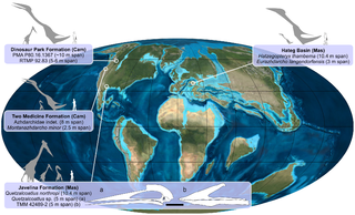
WHațeg Island was a large offshore island in the Tethys Sea which existed during the Late Cretaceous period, probably from the Cenomanian to the Maastrichtian ages. It was situated in an area corresponding to the region around modern-day Hațeg, Hunedoara County, Romania. Maastrichtian fossils of small-sized dinosaurs have been found in the island's rocks. It was formed mainly by tectonic uplift during the early Alpine orogeny, caused by the collision of the African and Eurasian plates towards the end of the Cretaceous. There is no real present-day analog, but overall, the island of Hainan is perhaps closest as regards climate, geology and topography, though still not a particularly good match. The vegetation, for example, was of course entirely distinct from today, as was the fauna.
WThe Helvetic zone, Helvetic system or the Helveticum is a geologic subdivision of the Alps. The Helvetic zone crops out mainly in Switzerland, hence the name. Rocks in the Helvetic zone are sedimentary and were originally deposited at the southern margin of the European plate. The Helvetic zone correlates with the French Dauphinois zone, French geologists often prefer the French name but normally this is considered the same thing.
WThe Hohe Tauern window is a geological structure in the Austrian Central Eastern Alps. It is a window in the Austroalpine nappes where high-grade metamorphic rocks of the underlying Penninic nappes crop out. The structure is caused by a large dome-like antiform in the nappe stacks of the Alps.
 W
WThe Iberian Plate with the microcontinent Iberia encompassed not only the Iberian Peninsula but also Corsica, Sardinia, the Balearic Islands, and the Briançonnais zone of the Penninic nappes of the Alps. Nowadays, the Iberian plate is a part of the Eurasian plate.
WThe Ivrea zone is a tectonic terrane in the Italian Alps, that consists of a steeply dipping piece of the Earth’s lower crust of the Apulian plate. The zone is named after the Italian city of Ivrea.
WThe Lepontine dome or Lepontin dome is a region of tectonic uplift in the Swiss part of the Alps. It is located in the Lepontine Alps and Glarus Alps.
WMain Dolomite is a lithostratigraphic unit in the Alps of Europe. Formation was defined by K.W. Gümbel in 1857.
 W
WThe Mindel glaciation is the third youngest glacial stage in the Alps. Its name was coined by Albrecht Penck and Eduard Brückner, who named it after the Swabian river, the Mindel. The Mindel glacial occurred in the Middle Pleistocene; it was preceded by the Haslach-Mindel interglacial and succeeded by the Mindel-Riss interglacial.
WThe Molasse basin is a foreland basin north of the Alps which formed during the Oligocene and Miocene epochs. The basin formed as a result of the flexure of the European plate under the weight of the orogenic wedge of the Alps that was forming to the south.
 W
WThe Partnach Formation is a Middle Triassic geologic formation in the eastern Northern Limestone Alps, within Austria, Central Europe.
WThe Penninic nappes or the Penninicum, commonly abbreviated as Penninic, are one of three nappe stacks and geological zones in which the Alps can be divided. In the western Alps the Penninic nappes are more obviously present than in the eastern Alps, where they crop out as a narrow band. The name Penninic is derived from the Pennine Alps, an area in which rocks from the Penninic nappes are abundant.
WThe Penninic thrustfront is a major tectonic thrustfront in the French Alps. The thrustfront moves over a developing decollement horizon, and separates the (internal) high grade metamorphic rocks of the Penninic nappes from the (external) sedimentary rocks and crystalline basement of the Helvetic nappes. The last are in France often called zone Dauphiné or Dauphinois.
WThe Periadriatic Seam is a distinct geologic fault in Southern Europe, running S-shaped about 1000 km from the Tyrrhenian Sea through the whole Southern Alps as far as Hungary. It forms the division between the Adriatic plate and the European plate. The term Insubric line is sometimes used to address the whole Periadriatic Seam, but it is more commonly used to mean just a western part of it.
WThe Piemont-Liguria basin or the Piemont-Liguria Ocean was a former piece of oceanic crust that is seen as part of the Tethys Ocean. Together with some other oceanic basins that existed between the continents Europe and Africa, the Piemont-Liguria Ocean is called the Western or Alpine Tethys Ocean.
 W
WThe Raibl Formation is a Middle Triassic geologic formation in the Northern and Southern Limestone mountain ranges of the Eastern Alps, in Central Europe.
WThe Rhone-Simplon line is a large geologic faultzone in the Swiss Alps.
WThe Riss glaciation, Riss Glaciation, Riss ice age, Riss Ice Age, Riss glacial or Riss Glacial is the second youngest glaciation of the Pleistocene epoch in the traditional, quadripartite glacial classification of the Alps. The literature variously dates it to between about 300,000 to 130,000 years ago and 347,000 to 128,000 years ago. It coincides with the Saale glaciation of North Germany. The name goes back to Albrecht Penck and Eduard Brückner who named this cold period after the river Riss in Upper Swabia in their three-volume work Die Alpen im Eiszeitalter published between 1901 and 1909.
WThe Schlern Formation, also known as Schlern Dolomite, is a limestone, marl and dolomite formation in the Northern Limestone Alps in Austria and Italy.
WThe Schrambach Formation is a geologic formation in the Northern Limestone Alps of Austria and Germany. It preserves fossils dating back to the Early Cretaceous period.
 W
WThe Schrattenkalk Formation is a Barremian to Aptian geologic formation in the Alps. The limestone is highly karstified. Fossil ornithopod tracks have been reported from the formation. Iguanodont tracks have been registered in the Swiss portion of the formation. The famous north face of the Eiger is partly composed of Schrattenkalk, as well as the Sturmannshöhle in southernmost Bavaria, Germany, and the Hölloch and Silberen system karst caves in Switzerland.
WThe Sesia unit or Sesia nappe, also called the Sesia-Dent Blanche unit is a tectonic unit or terrane in the Swiss and Italian Alps. The zone crops out in the Pennine Alps and in the southeastern part of the Aosta Valley. It is widely seen as part of the Austroalpine nappes and correlated with the Dent Blanche nappe that crops out further to the northwest.
WThe Southern Alps are a geological subdivision of Alps that are found south of the Periadriatic Seam, a major geological faultzone across the Alps. The southern Alps contain almost the same area as the Southern Limestone Alps. The rocks of the southern Alps gradually go over in the Dinarides or Dinaric Alps to the south-east. In the south-west they disappear below recent sediments of the Po basin that are lying discordant on top of them.
 W
WThe Tristel Formation is a stratigraphic formation of the northern-central Alps, deposited between the late Barremian and the early Aptian of the Early Cretaceous. It consists of thickly banked limestones, marls and shales. It is the lowest formation of the Bündnerschiefer and belongs to the Rhenodanubic Group.
WThe Valais Ocean is a subducted oceanic basin which was situated between the continent Europe and the microcontinent Iberia or so called Briançonnais microcontinent. Remnants of the Valais ocean are found in the western Alps and in tectonic windows of the eastern Alps and are mapped as the so-called "north Penninic" nappes.
 W
WThe Wetterstein Formation is a regional geologic formation of the Northern Limestone Alps and Western Carpathians extending from southern Bavaria, Germany in the west, through northern Austria to northern Hungary and western Slovakia in the east. The formation dates back to the Ladinian to Carnian stages of the Late Triassic. The formation is named after the Wetterstein Mountains in southern Germany and northwestern Austria. The center of its distribution, however, is in the Karwendel Mountains. It occurs in the Northern and Southern Limestone Alps and in the Western Carpathians.
WThe Würm glaciation or Würm stage, in the literature usually just referred to as the Würm, often spelt "Wurm", was the last glacial period in the Alpine region. It is the youngest of the major glaciations of the region that extended beyond the Alps themselves. It is, like most of the other ice ages of the Pleistocene epoch, named after a river, the Würm in Bavaria, a tributary of the Amper. The Würm ice age can be dated to the time about 115,000 to 11,700 years ago, the sources differing depending on whether the long transition phases between the glacials and interglacials are allocated to one or other of these periods. The average annual temperatures during the Würm ice age in the Alpine Foreland were below −3 °C. This has been determined from changes in the vegetation as well as differences in the facies.