 W
WRadio navigation or radionavigation is the application of radio frequencies to determine a position of an object on the Earth, either the vessel or an obstruction. Like radiolocation, it is a type of radiodetermination.
 W
WAeronautical radionavigation service is – according to Article 1.46 of the International Telecommunication Union's (ITU) Radio Regulations (RR) – defined as «A radionavigation service intended for the benefit and for the safe operation of aircraft.»
 W
WAmateur radio direction finding is an amateur racing sport that combines radio direction finding with the map and compass skills of orienteering. It is a timed race in which individual competitors use a topographic map, a magnetic compass and radio direction finding apparatus to navigate through diverse wooded terrain while searching for radio transmitters. The rules of the sport and international competitions are organized by the International Amateur Radio Union. The sport has been most popular in Eastern Europe, Russia, and China, where it was often used in the physical education programs in schools.
 W
WArea navigation is a method of instrument flight rules (IFR) navigation that allows an aircraft to choose any course within a network of navigation beacons, rather than navigate directly to and from the beacons. This can conserve flight distance, reduce congestion, and allow flights into airports without beacons. Area navigation used to be called "random navigation", hence the acronym RNAV.
 W
WAn automatic direction finder (ADF) is a marine or aircraft radio-navigation instrument that automatically and continuously displays the relative bearing from the ship or aircraft to a suitable radio station. ADF receivers are normally tuned to aviation or marine NDBs operating in the LW band between 190 – 535 kHz. Like RDF units, most ADF receivers can also receive medium wave (AM) broadcast stations, though as mentioned, these are less reliable for navigational purposes.
 W
WChayka is a Russian terrestrial radio navigation system, similar to Loran-C. It operates on similar frequencies around 100 kHz, and uses the same techniques of comparing both the envelope and the signal phase to accurately determine location. The systems differ primarily in details.
 W
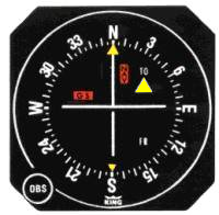
WA course deviation indicator (CDI) is an avionics instrument used in aircraft navigation to determine an aircraft's lateral position in relation to a course to or from a radio navigation beacon. If the location of the aircraft is to the left of this course, the needle deflects to the right, and vice versa.
WThe Decca Navigator System was a hyperbolic radio navigation system which allowed ships and aircraft to determine their position by receiving radio signals from fixed navigational beacons. The system used phase comparison of two low frequency signals between 70 and 129 kHz, as opposed to pulse timing systems like Gee and LORAN. This made it much easier to implement the receivers using 1940s electronics, eliminating the need for a cathode ray tube.
 W
WDirection finding (DF), or radio direction finding (RDF), is the measurement of the direction from which a received signal was transmitted. This can refer to radio or other forms of wireless communication, including radar signals detection and monitoring (ELINT/ESM). By combining the direction information from two or more suitably spaced receivers, the source of a transmission may be located via triangulation. Radio direction finding is used in the navigation of ships and aircraft, to locate emergency transmitters for search and rescue, for tracking wildlife, and to locate illegal or interfering transmitters. RDF was important in combating German threats during both the World War II Battle of Britain and the long running Battle of the Atlantic. In the former, the Air Ministry also used RDF to locate its own fighter groups and vector them to detected German raids.
 W
WDistance measuring equipment (DME) is a radio navigation technology that measures the slant range (distance) between an aircraft and a ground station by timing the propagation delay of radio signals in the frequency band between 960 and 1215 megahertz (MHz). Line-of-visibility between the aircraft and ground station is required. An interrogator (airborne) initiates an exchange by transmitting a pulse pair, on an assigned 'channel', to the transponder ground station. The channel assignment specifies the carrier frequency and the spacing between the pulses. After a known delay, the transponder replies by transmitting a pulse pair on a frequency that is offset from the interrogation frequency by 63 MHz and having specified separation.
 W
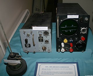
WGee, sometimes written GEE, was a radio navigation system used by the Royal Air Force during World War II. It measured the time delay between two radio signals to produce a fix, with accuracy on the order of a few hundred metres at ranges up to about 350 miles (560 km). It was the first hyperbolic navigation system to be used operationally, entering service with RAF Bomber Command in 1942.
 W
WThe horizontal situation indicator is an aircraft flight instrument normally mounted below the artificial horizon in place of a conventional heading indicator. It combines a heading indicator with a VHF omnidirectional range-instrument landing system (VOR-ILS) display. This reduces pilot workload by lessening the number of elements in the pilot's instrument scan to the six basic flight instruments. Among other advantages, the HSI offers freedom from the confusion of reverse sensing on an instrument landing system localizer back course approach. As long as the needle is set to the localizer front course, the instrument will indicate whether to fly left or right, in either direction of travel.
 W
WHyperbolic navigation is a class of obsolete radio navigation systems in which a navigation receiver instrument on a ship or aircraft is used to determine location based on the difference in timing of radio waves received from fixed land-based radio navigation beacon transmitters. Measuring the difference in timing (phase) of radio signals received from two beacons gives the difference in distance of the receiver from the beacons. Plotting all of the potential locations of the receiver for the measured delay localizes the receiver to a hyperbolic line on a chart. Taking timing measurements from two pairs of beacons gives two such hyperbolic lines, and the receiver's location is at the intersection of the lines. The two lines may intersect in two points, in which case other navigation information is used to determine which point is the receiver's location.
iBeacon is a protocol developed by Apple and introduced at the Apple Worldwide Developers Conference in 2013. Various vendors have since made iBeacon-compatible hardware transmitters – typically called beacons – a class of Bluetooth Low Energy (BLE) devices that broadcast their identifier to nearby portable electronic devices. The technology enables smartphones, tablets and other devices to perform actions when in proximity to an iBeacon.
 W
WAn instrument landing system (ILS) is a system that works by sending radio waves downrange from the runway end, with aircraft that intercept it using the radio waves to guide them onto the runway. It is defined by the International Telecommunication Union as a service provided by a station as follows:A radionavigation system which provides aircraft with horizontal and vertical guidance just before and during landing and, at certain fixed points, indicates the distance to the reference point of landing.
 W
WInstrument landing system glide path, commonly referred to as a glide path (G/P) or glide slope (G/S), is "a system of vertical guidance embodied in the instrument landing system which indicates the vertical deviation of the aircraft from its optimum path of descent", according to Article 1.106 of the ITU Radio Regulations.
WAn instrument landing system localizer, or simply localizer (LOC), is a system of horizontal guidance in the instrument landing system, which is used to guide aircraft along the axis of the runway.See also
 W
WLORAN, short for long range navigation, was a hyperbolic radio navigation system developed in the United States during World War II. It was similar to the UK's Gee system but operated at lower frequencies in order to provide an improved range up to 1,500 miles (2,400 km) with an accuracy of tens of miles. It was first used for ship convoys crossing the Atlantic Ocean, and then by long-range patrol aircraft, but found its main use on the ships and aircraft operating in the Pacific theater during World War II.
 W
WLoran-C was a hyperbolic radio navigation system that allowed a receiver to determine its position by listening to low frequency radio signals transmitted by fixed land-based radio beacons. Loran-C combined two different techniques to provide a signal that was both long-range and highly accurate, features that had formerly been incompatible. The disadvantage was the expense of the equipment needed to interpret the signals, which meant that Loran-C was used primarily by militaries after it was first introduced in 1957.
 W
WThe low-frequency radio range, also known as the four-course radio range, LF/MF four-course radio range, A-N radio range, Adcock radio range, or commonly "the range", was the main navigation system used by aircraft for instrument flying in the 1930s and 1940s, until the advent of the VHF omnidirectional range (VOR), beginning in the late 1940s. It was used for en route navigation as well as instrument approaches and holds.
 W
WMaritime radionavigation service is – according to Article 1.44 of the International Telecommunication Union's (ITU) Radio Regulations (RR) – defined as "A radionavigation service intended for the benefit and for the safe operation of ships."
 W
WMaritime radionavigation-satellite service is – according to Article 1.45 of the International Telecommunication Union's (ITU) Radio Regulations (RR) – defined as «A radionavigation-satellite service in which earth stations are located on board ships.»
 W
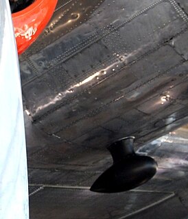
WA marker beacon is a particular type of VHF radio beacon used in aviation, usually in conjunction with an instrument landing system (ILS), to give pilots a means to determine position along an established route to a destination such as a runway.
 W
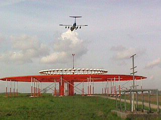
WThe microwave landing system (MLS) is an all-weather, precision radio guidance system intended to be installed at large airports to assist aircraft in landing, including 'blind landings'. MLS enables an approaching aircraft to determine when it is aligned with the destination runway and on the correct glidepath for a safe landing. MLS was intended to replace or supplement the instrument landing systems (ILS). MLS has a number of operational advantages over ILS, including a wider selection of channels to avoid interference with nearby installations, excellent performance in all weather, a small "footprint" at the airports, and wide vertical and horizontal "capture" angles that allowed approaches from wider areas around the airport.
WThe microwave landing system (MLS) is an all-weather, precision radio guidance system intended to be installed at large airports to assist aircraft in landing, including 'blind landings'. MLS enables an approaching aircraft to determine when it is aligned with the destination runway and on the correct glidepath for a safe landing. MLS was intended to replace or supplement the instrument landing systems (ILS). MLS has a number of operational advantages over ILS, including a wider selection of channels to avoid interference with nearby installations, excellent performance in all weather, a small "footprint" at the airports, and wide vertical and horizontal "capture" angles that allowed approaches from wider areas around the airport.
 W
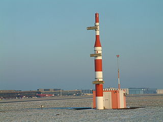
WA non-directional (radio) beacon (NDB) is a radio transmitter at a known location, used as an aviation or marine navigational aid. As the name implies, the signal transmitted does not include inherent directional information, in contrast to other navigational aids such as low frequency radio range, VHF omnidirectional range (VOR) and TACAN. NDB signals follow the curvature of the Earth, so they can be received at much greater distances at lower altitudes, a major advantage over VOR. However, NDB signals are also affected more by atmospheric conditions, mountainous terrain, coastal refraction and electrical storms, particularly at long range.
 W
WOboe was a British aerial blind bombing system in World War II, based on radio transponder technology. The system consisted of a pair of radio transmitters on the ground, which sent signals which were received and retransmitted by a transponder in the aircraft. By comparing the time each signal took to reach the aircraft, the distance between the aircraft and the station could be determined. The Oboe operators then sent radio signals to the aircraft to bring them onto their target and properly time the release of their bombs.
 W
WOMEGA was the first global-range radio navigation system, operated by the United States in cooperation with six partner nations. It was a hyperbolic navigation system, enabling ships and aircraft to determine their position by receiving very low frequency (VLF) radio signals in the range 10 to 14 kHz, transmitted by a global network of eight fixed terrestrial radio beacons, using a navigation receiver unit. It became operational around 1971 and was shut down in 1997 in favour of the Global Positioning System.
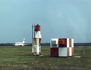
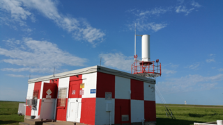
The Orfordness Rotating Wireless Beacon, known simply as the Orfordness Beacon or sometimes the Black Beacon, was an early radio navigation system introduced by the United Kingdom in July 1929. It allowed the angle to the station to be measured from any aircraft or ship with a conventional radio receiver, and was accurate to about a degree. A second station operating on the same principle was set up to provide wider area coverage and allow two-bearing fixes between Orford Ness and Farnborough Airport. The system was similar to the earlier German Telefunken Kompass Sender and the later Sonne system.
 W
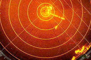
WRadar beacon is – according to article 1.103 of the International Telecommunication Union′s (ITU) ITU Radio Regulations (RR) – defined as "A transmitter-receiver associated with a fixed navigational mark which, when triggered by a radar, automatically returns a distinctive signal which can appear on the display of the triggering radar, providing range, bearing and identification information." Each station shall be classified by the service in which it operates permanently or temporarily.
 W
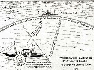
WRadio acoustic ranging, occasionally written as "radio-acoustic ranging" and sometimes abbreviated RAR, was a method for determining a ship's precise location at sea by detonating an explosive charge underwater near the ship, detecting the arrival of the underwater sound waves at remote locations, and radioing the time of arrival of the sound waves at the remote stations to the ship, allowing the ship's crew to use true range multilateration to determine the ship's position. Developed by the United States Coast and Geodetic Survey in 1923 and 1924 for use in accurately fixing the position of survey ships during hydrographic survey operations, it was the first navigation technique in human history other than dead reckoning that did not require visual observation of a landmark, marker, light, or celestial body, and the first non-visual means to provide precise positions. First employed operationally in 1924, radio acoustic ranging remained in use until 1944, when new radio navigation techniques developed during World War II rendered it obsolete.
 W
WIn navigation, a radio beacon is a kind of beacon, a device that marks a fixed location and allows direction-finding equipment to find relative bearing. Radio beacons transmit a radio signal that is picked up by radio direction-finding systems on ships, aircraft and vehicles to determine the direction to the beacon.
WRadio direction-finding station is – according to article 1.91 of the International Telecommunication Union's (ITU) ITU Radio Regulations (RR) – defined as «A radiodetermination station using radio direction-finding.»
 W
WRadionavigation land station is – according to article 1.88 of the International Telecommunication Union´s (ITU) ITU Radio Regulations (RR) – defined as «A radio station in the radionavigation service not intended to be used while in motion.»
 W
WA radionavigation-satellite service (RNSS) is "a radiodetermination-satellite service used for the purpose of radionavigation. This service may also include feeder links necessary for its operation".
Rohde & Schwarz Federal Systems, Inc. is a U.S. company set up to distribute Rohde & Schwarz products and services for U.S. government and contractor customers. Rohde & Schwarz Federal Systems is organized as an SSA company.
 W
WSafety service is – according to Article 1.59 of the International Telecommunication Union´s (ITU) Radio Regulations (RR) – defined as «A radiocommunication service used permanently or temporarily for the safeguarding of human life and property.»
 W
WThe SCR-277 was a mobile, trailer mounted radio range set for radio guidance of aircraft. It was standardized by the U.S. Army in June 1941.
 W
WA tactical air navigation system, commonly referred to by the acronym TACAN, is a navigation system used by military aircraft. It provides the user with bearing and distance to a ground or ship-borne station. It is a more accurate version of the VOR/DME system that provides bearing and range information for civil aviation. The DME portion of the TACAN system is available for civil use; at VORTAC facilities where a VOR is combined with a TACAN, civil aircraft can receive VOR/DME readings. Aircraft equipped with TACAN avionics can use this system for en route navigation as well as non-precision approaches to landing fields. The space shuttle is one such vehicle that was designed to use TACAN navigation but later upgraded with GPS as a replacement.
A tracking system, also known as a locating system, is used for the observing of persons or objects on the move and supplying a timely ordered sequence of location data for further processing.
 W
WA transponder landing system (TLS) is an all-weather, precision landing system that uses existing airborne transponder and instrument landing system (ILS) equipment to create a precision approach at a location where an ILS would normally not be available.
u-blox is a Swiss company that creates wireless semiconductors and modules for consumer, automotive and industrial markets. They operate as a fabless IC and design house.
WVery high frequency omni-directional range (VOR) is a type of short-range radio navigation system for aircraft, enabling aircraft with a receiving unit to determine its position and stay on course by receiving radio signals transmitted by a network of fixed ground radio beacons. It uses frequencies in the very high frequency (VHF) band from 108.00 to 117.95 MHz. Developed in the United States beginning in 1937 and deployed by 1946, VOR is the standard air navigational system in the world, used by both commercial and general aviation. In the year 2000 there were about 3,000 VOR stations operating around the world including 1,033 in the US, reduced to 967 by 2013.
 W
WIn the United States and Canada, Victor airways are low-altitude airways. They are defined in straight-line segments, each of which is based on a straight line between either two VHF omnidirectional range (VOR) stations, or a VOR and a VOR intersection, hence the beginning letter V.
 W
WA VORTAC is a radio-based navigational aid for aircraft pilots consisting of a co-located VHF omnidirectional range (VOR) beacon and a tactical air navigation system (TACAN) beacon. Both types of beacons provide pilots azimuth information, but the VOR system is generally used by civil aircraft and the TACAN system by military aircraft. However, the TACAN distance measuring equipment is also used for civil purposes because civil DME equipment is built to match the military DME specifications. Most VOR installations in the United States are VORTACs. The system was designed and developed by the Cardion Corporation.