 W
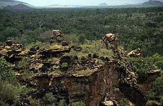
WBarranyi National Park is in the Gulf of Carpentaria in the Northern Territory of Australia, 737 km southeast of Darwin.
 W
WBeringa Reserve, formerly known as Peniup Creek Reserve, is a 25.06 km2 nature reserve in south-west Western Australia. It lies about 380 km south-east of Perth. It is owned and managed by Bush Heritage Australia (BHA), by which it was purchased jointly with Greening Australia (WA) in 2007, and forms part of the Gondwana Link project, in which BHA is a partner.
 W
WThe Burrowa-Pine Mountain National Park is a national park in the Hume region of Victoria, Australia. The 18,400-hectare (45,000-acre) national park is situated approximately 315 kilometres (196 mi) northeast of Melbourne and 120 kilometres (75 mi) east of Albury-Wodonga.
 W
WCentral Plateau Conservation Area is an animal and plant conservation area in Tasmania, Australia. It is adjacent to the Walls of Jerusalem National Park.
 W
WCoal Mines Historic Site was, for a period of 15 years (1833–48), a convict probation station and the site of Tasmania's first operational coal mine, "serving as a place of punishment for the 'worst class' of convicts from Port Arthur".
 W
WThe Cobboboonee National Park is a national park located in the Barwon South West region of Victoria, Australia. The 18,510-hectare (45,700-acre) national park is situated approximately 360 kilometres (220 mi) west of Melbourne city centre, with access via the town of Heywood near the junctions of the Princes and Henty highways, north of Portland.
 W
WThe Coopracambra National Park is a national park located in the Gippsland region of Victoria, Australia. The 38,800-hectare (96,000-acre) national park is situated approximately 460 kilometres (290 mi) east of Melbourne and 250 kilometres (160 mi) south of Canberra, near the town of Cann River.
 W
WCoringa-Herald National Nature Reserve is a former nature reserve in Australia’s Coral Sea Islands Territory that was incorporated into the new Coral Sea Commonwealth Marine Reserve in December 2012. The former nature reserve together with the Lihou Reef National Nature Reserve is part of the Coral Sea Reserves Ramsar Site. Its extent is also within the Coringa-Herald Reefs Important Bird Area.
 W
WDarlington Probation Station was a convict penal settlement on Maria Island, Tasmania, from 1825 to 1832, then later a convict probation station during the last phase of convict management in eastern Australia (1842–1850).
 W
WDevils Gullet is a protected area in Tasmania, Australia. It is part of the Tasmanian Wilderness. From the reserve, visitors unable or unwilling to hike the challenging Walls of Jerusalem National Park can catch a glimpse of the stunning landscape. The viewing platform is located near Mole Creek Karst National Park.
WDjukbinj National Park is a protected area in the Northern Territory of Australia located about 66 km (41 mi) east-south-east of the territory capital of Darwin.
 W
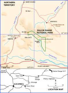
WDulcie Range is a national park in the Northern Territory of Australia, 220 km north-east of Alice Springs and 1235 km southeast of territorial capital of Darwin. The park lies along the south-western edge of Dulcie Range. It was first declared in 1991 and again in July 2012. A draft Plan of Management was published by the Parks and Wildlife Commission of the Northern Territory in May 2001.
WEast Risdon State Reserve is an IUCN Category II protected area on the eastern shore of the Derwent River in Clarence City, Hobart, Tasmania. It takes its name from the nearby suburb of Risdon.
 W
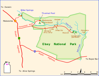
WElsey is a national park in the Northern Territory of Australia, extending from 2 km to 19 km east of Mataranka and 378 km southeast of Darwin.
WEurardy Reserve is a 30,050-hectare (74,300-acre) nature reserve in Western Australia. It is 145 kilometres (90 mi) north of Geraldton, 275 kilometres (171 mi) south of Carnarvon and 530 kilometres (330 mi) north of Perth. It lies on the northern edge of the South West Botanical Province, adjoining Kalbarri National Park, and is owned and managed by Bush Heritage Australia (BHA), by which it was purchased in 2005.
The French Island National Park is a national park located in the Greater Melbourne region of Victoria, Australia. The 11,100-hectare (27,000-acre) national park is 61 kilometres (38 mi) southeast of Melbourne on French Island within Western Port and accessible only via water.
 W
WThe Gap Scenic Reserve is situated in the state of Victoria in south eastern Australia. It is a small reserve in isolated forest country beside the Bonang Highway. The reserve features tall eucalyptus trees and ferny gullies. Significant tree species include mountain grey gum, messmate and the shining gum. Threatened fauna includes powerful owls, tiger quolls and long-footed potoroos.
WGarig Gunak Barlu is a protected area in the Northern Territory of Australia on the Cobourg Peninsula and some adjoining waters about 216 kilometres (134 mi) north-east of the territory capital of Darwin.
WThe Gippsland Lakes Coastal Park is a coastal park in the East Gippsland region of Victoria, Australia. The park is located approximately 240 km (150 mi) east of the capital city of Melbourne.
 W
WThe Greater Bendigo National Park is a national park located in the Loddon Mallee region of Victoria, Australia. The 17,020-hectare (42,100-acre) national park was created in 2002 from the former Whipstick State Park, Kamarooka State Park, One Tree Hill Regional Park, Mandurang State Forest and the Sandhurst State Forest.
WThe Gunbower National Park is a national park located in the Loddon Mallee region of Victoria, Australia. The 9,330-hectare (23,100-acre) national park is situated between Echuca and Koondrook adjacent to the banks of the Murray River, approximately 250 kilometres (160 mi) north of Melbourne and was established in June 2010. The park contains the Gunbower Forest Ramsar wetlands site for the protection of migratory bird species.
 W
WThe Heathcote-Graytown National Park is a national park located in the North Central region of Victoria, Australia. The 12,833-hectare (31,710-acre) national park, which includes sections of the Great Dividing Range, adjoins a number of state forests, including the McIvor Ranges State Forest and is located just outside the town of Heathcote.
 W
WThe Kara Kara National Park is a national park located in the Wimmera/Goldfields region of Victoria, Australia. The 13,990-hectare (34,600-acre) national park is situated approximately 190 kilometres (120 mi) north-west of Melbourne, west of the Sunraysia Highway, and to the south of the town of St Arnaud.
 W
WKeep River National Park is in the Northern Territory of Australia, 418 km southwest of Darwin and 468 km west of Katherine. The nearest town is Kununurra in Western Australia.
WKojonup Reserve is a 389-hectare (960-acre) nature reserve in south-west Western Australia. It is 30 kilometres (19 mi) north-east of Kojonup, 196 kilometres (122 mi) north-west of Albany and 270 kilometres (170 mi) south-east of Perth. It is owned and managed by Bush Heritage Australia (BHA), by which it was purchased in 1996.
 W
WThe Lakes National Park is a national park in the East Gippsland region of Victoria, Australia. The national park is located approximately 245 km (152 mi) east of the capital city of Melbourne.
WThe Lind National Park is a national park in the East Gippsland region of Victoria, Australia. The 1,370-hectare (3,400-acre) national park is situated approximately 419 kilometres (260 mi) east of Melbourne, adjacent to the Princes Highway between Orbost and Cann River.
 W
WLord Howe Island Marine Park is a former marine protected area managed by the Commonwealth Department of the Environment, protecting the waters surrounding Lord Howe Island. It was adjacent to the 465.45 km² Lord Howe Island Marine Park managed by the Marine Parks Authority New South Wales. On 8 November 2012, it was replaced by a new protected area known as the Lord Howe Commonwealth Marine Reserve.
WThe Lower Glenelg National Park is a national park in the Western District of Victoria, Australia. The 27,300-hectare (67,000-acre) national park is situated approximately 323 kilometres (201 mi) west of Melbourne. The major features of the park are the Glenelg River gorge and the Princess Margaret Rose Cave. Much of the route of the Great South West Walk is located within the national park.
WThe Lower Goulburn National Park is a national park located in the Goulburn Valley district of Victoria, Australia. The 9,310-hectare (23,000-acre) linear national park protects the lower Goulburn River from Shepparton to its river mouth near Echuca where it forms confluence with the Murray River.
 W
WFor the cattle station in the channel country of Queensland, see Marion Downs Station
 W
WMornington Station refers to the new Mornington Wilderness Camp in the Kimberley in Western Australia.
 W
WThe Morwell National Park is a national park located in the western Gippsland region of Victoria, Australia. The 565-hectare (1,400-acre) national park is situated approximately 164 kilometres (102 mi) east of Melbourne via the Princes Highway and 16 kilometres (9.9 mi) south of Morwell in the Strzelecki Ranges. The park preserves a remnant of previously widespread wet sclerophyll forests and some rainforest remnants restricted to deep creek gullies. 320 plant species have been recorded for this park, including five rare or threatened species and 44 orchid species. 129 native fauna species have been recorded, including 19 mammals, 96 birds, 11 reptiles and three amphibians.
 W
WMount Napier State Park is a state park in the Australian state of Victoria. It is 20 km northeast of Mount Eccles; its centerpiece is Mount Napier, a true volcanic cone. The park was established in 1987, and today encompasses 2800 hectares of land. The local Aboriginal name for the mount is Tapoc.
WThe Mount Richmond National Park is a national park located in the Barwon South West region of Victoria, Australia. The 1,733-hectare (4,280-acre) national park is situated approximately 313 kilometres (194 mi) west of Melbourne and 18 kilometres (11 mi) west of Portland. Part of the route of the Great South West Walk is located within the park.
 W
WThe Nombinnie Nature Reserve is a protected nature reserve in central New South Wales.
 W
WParuna Sanctuary is a 20-square-kilometre (7.7 sq mi) nature reserve in the Avon Valley, 50 kilometres (31 mi) north-east of Perth in south-west Western Australia. It is in the Avon-Wheatbelt Bioregion and is owned and managed by the Australian Wildlife Conservancy (AWC).
 W
WThe Pound Bend Tunnel, or the Evelyn Tunnel, is a diversion tunnel on the Yarra River at Warrandyte, Victoria, Australia, approximately 24 km north-east of Melbourne. The tunnel is 145 metres long, six metres wide and four metres deep.
WThe Sister Islands Conservation Area, commonly called the Sisters Island Group, is a conservation area of approximately 1,200 hectares that comprises a group of three islands in Bass Strait, Tasmania, Australia.
 W
WThe Terrick Terrick National Park is a national park located in the region of Victoria, Australia. The 3,880-hectare (9,600-acre) national park was declared in June 1988 and is situated approximately 225 kilometres (140 mi) northwest of Melbourne, 4 kilometres (2.5 mi) north of the town of Mitiamo and 65 kilometres (40 mi) north of Bendigo. The national park is an important remnant of Box-Ironbark forests and northern grass plains and is close to Kow Swamp, the site of a major palaeontological find providing insight into the origins of Indigenous Australians. There are many walking tracks and one basic campground. Drinking water is not available in the park and must be carried.
WThe Thomson River Diversion Tunnel, also known as the Horseshoe Bend Tunnel or the Chinese Tunnel, is located on the Thomson River near the junction with Coopers Creek, approximately 4 kilometres (2.5 mi) south-west of Walhalla, Victoria, Australia. The site is listed on the Victorian Heritage Register and covered by a Heritage Overlay.
 W
WTrephina Gorge is a gorge in the Northern Territory of Australia located in the locality of Hart in the East MacDonnell Ranges about 85 kilometres (53 mi) east of Alice Springs.
WWatarrka National Park is a protected area in the Northern Territory of Australia located about 1,316 kilometres south of the territory capital of Darwin and 323 kilometres southwest of Alice Springs.
WWellington Park is the protected area which encompasses kunanyi / Mount Wellington and surrounds near Hobart, Tasmania. There are numerous hiking and mountain bike tracks within the park of varying difficulty.
 W
WWest MacDonnell is a national park in the Northern Territory (Australia) due west of Alice Springs and 1234 km south of Darwin. It extends along the MacDonnell Ranges west of Alice Springs.
WYarrabee Wesfarmers Reserve is a 9.23 km2 nature reserve in south-west Western Australia. It is 120 km north-east of Albany and 481 km south-east of Perth. It lies on the eastern boundary of the Stirling Range National Park, and is managed by Bush Heritage Australia (BHA), by which it was purchased in 2006 with the financial assistance of Wesfarmers. It is jointly owned by BHA and by Greening Australia (WA), and forms part of BHA's Gondwana Link project.