 W
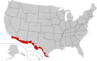
WThe Mexico–United States border is an international border separating Mexico and the United States, extending from the Pacific Ocean in the west to the Gulf of Mexico in the east. The border traverses a variety of terrains, ranging from urban areas to deserts. The Mexico–United States border is the most frequently crossed border in the world, with approximately 350 million documented crossings annually. It is the tenth-longest border between two countries in the world.
 W
WDemonstrations were held throughout the United States on Presidents Day, February 18, 2019, in protest of President Donald Trump's declaration of a national emergency to construct a new wall extending the barrier along the southern border. Because schools were closed on Presidents Day, many young people were able to participate.
 W
WThe Adams–Onís Treaty of 1819, also known as the Transcontinental Treaty, the Florida Purchase Treaty, or the Florida Treaty, was a treaty between the United States and Spain in 1819 that ceded Florida to the U.S. and defined the boundary between the U.S. and New Spain. It settled a standing border dispute between the two countries and was considered a triumph of American diplomacy. It came in the midst of increasing tensions related to Spain's territorial boundaries in North America against the United States and the United Kingdom in the aftermath of the American Revolution; it also came during the Latin American wars of independence.
 W
WThe 2015 Amado checkpoint protest took place on May 27, 2015, when approximately seventy-five protesters held a demonstration at the United States Border Patrol checkpoint along Arivaca Road in Amado, Arizona, about 35 miles south of Tucson.
 W
WAmistad National Recreation Area is a park unit managed by National Park Service (NPS) that includes the area around the Amistad Reservoir at the confluence of the Rio Grande, the Devils River, and the Pecos River near Del Rio in Val Verde County, Texas. The reservoir was created by the Amistad Dam, completed in 1969, located on the Rio Grande at the United States-Mexico border across from the city of Ciudad Acuña in the Mexican state of Coahuila. Amistad, Spanish for "friendship," refers broadly to the close relationship and shared history between Ciudad Acuña and Del Rio.
 W
WAmistad Reservoir is a reservoir on the Rio Grande at its confluence with the Devils River 12 miles (19 km) northwest of Del Rio, Texas. The lake is bounded by Val Verde County on the United States side of the international border and by the state of Coahuila on the Mexican side of the border; the American shoreline forms the Amistad National Recreation Area. The reservoir was formed in 1969 by the construction of Amistad Dam. The dam and lake are managed jointly by the governments of the United States and Mexico through the International Boundary and Water Commission. The name of the dam and lake is the Spanish word for "friendship". The reservoir is also known as Lake Amistad.
 W
WAnáhuac Municipality is one of the municipalities, of the Mexican state of Nuevo León. The city of Anáhuac was founded on May 5, 1933, inside the municipal jurisdiction of Lampazos de Naranjo, Nuevo León, as the political head of the National System of Irrigation No.04 (SNI). On May 29, 1935, this city was declared a municipality. By decision of the Government of the State the municipal territory annexed the abandoned community of Colombia, Nuevo León in 1978. From 1992, Anáhuac Municipality has received federal contributions for the commercial use of the Colombia-Solidarity International Bridge, which is the only international border crossing between Nuevo León and Texas. Anáhuac Municipality is divided into eight regions: Estación Rodríguez, Ejido Nuevo Rodríguez, Ejido Camarón, Ejido Nuevo Anáhuac, Ejido Rodríguez, Ciudad Anáhuac, Salinillas, and Regantes.
 W
WThe Mexico–United States barrier, also known as the border wall, is a series of vertical barriers along the Mexico–United States border intended to reduce illegal immigration to the United States from Mexico. The barrier is not a continuous structure but a series of obstructions variously classified as "fences" or "walls".
 W
WBorder is a 2007 documentary directed by Chris Burgard that deals with the United States–Mexico border and the current activities pertaining to it. The film crew visits various states along the border, documenting illegal immigration, drug trafficking, American and Mexican civil unrest and the effects that these issues are having on the residents of both countries.
 W
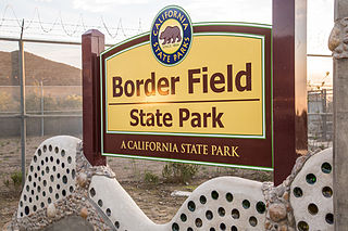
WBorder Field State Park is a state park of California, United States, containing beach and coastal habitat on the Mexico–United States border. The park is within the city limits of Imperial Beach in San Diego County, next to the suburb of Playas de Tijuana in Mexico. It contains the southernmost point in the state of California. The refuge forms the southern part of the Tijuana River National Estuarine Research Reserve.
 W
WThe Build the Wall, Enforce the Law Act of 2018 is a proposed United States Congress bill to fund President Donald Trump's border wall along the Mexico–United States border and to follow federal immigration law. Estimated at $23.4 billion, the bill, along with the $1.6 billion from the Consolidated Appropriations Act, 2018, would amount to the $25 billion projected to complete the larger and fortified wall.
 W
WThe Central American migrant caravans, also known as the Viacrucis del Migrante, are migrant caravans that travel from the Guatemala–Mexico border to the Mexico–United States border. The largest and best known of these were organized by Pueblo Sin Fronteras that set off during Holy Week in early 2017 and 2018 from the Northern Triangle of Central America (NTCA), but such caravans of migrants began arriving several years earlier, and other unrelated caravans continued to arrive into late 2018.
 W
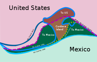
WThe Chamizal dispute was a border conflict over about 600 acres (2.4 km2) on the Mexico–United States border between El Paso, Texas, and Ciudad Juárez, Chihuahua. It was caused by a shift in the Rio Grande, as a survey presented in 1852 marked differences between the bed of the Rio Grande and the present channel of the river. Tensions over the territory during the historic Taft–Diaz summit almost resulted in the attempted assassination of both presidents on October 16, 1909.
 W
WChamizal National Memorial, located in El Paso, Texas, along the United States–Mexico international border, is a National Park Service site commemorating the peaceful settlement of the Chamizal boundary dispute.
 W
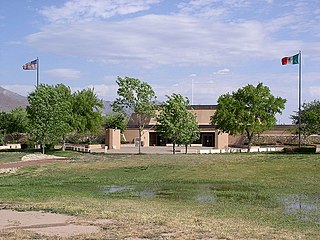
WThe Coronado National Memorial commemorates the first organized expedition into the Southwest by conquistador Francisco Vásquez de Coronado in 1540. The memorial is located in a natural setting on the Mexico–United States border on the southeast flank of the Huachuca Mountains south of Sierra Vista, Arizona and is bordered to the north and west by Coronado National Forest. Within the memorial is an overlook at Montezuma Pass where the Coronado expedition entered modern Arizona. The memorial confirms the ties that bind the United States and Mexico.
 W
WEl Camino del Diablo is a historic 250-mile (400 km) road that currently extends through some of the most remote and arid terrain of the Sonoran Desert in Pima County and Yuma County, Arizona. In use for at least 1,000 years, El Camino del Diablo is believed to have started as a series of footpaths used by desert-dwelling Native Americans. From the 16th to the 19th centuries, the road was used extensively by conquistadores, explorers, missionaries, settlers, miners, and cartographers. Use of the trail declined sharply after the railroad reached Yuma in 1870. In recognition of its historic significance, El Camino del Diablo was listed on the National Register of Historic Places in 1978. It has also been designated a Bureau of Land Management Back Country Byway.
 W
WEnvironmental issues along the Mexico–United States border illustrate the challenges faced in the management of bi-national distribution of shared resources, limited water supplies, conservation of ecosystems, and pollution. These issues are increased in changes of population growth, policy, and climate change.
 W
WExecutive Order 13767, titled Border Security and Immigration Enforcement Improvements, was issued by United States President Donald Trump on January 25, 2017. The order directs a wall, colloquially called the "Trump wall", to be built along the Mexico–United States border. On December 22, 2018, the federal government went into a shutdown due to Trump's demand for $5.6 billion in federal funds to begin work on the wall. By January 12, 2019, the shutdown became the longest budget shutdown in U.S. history.
 W
WThe Gadsden Purchase is a 29,670-square-mile (76,800 km2) region of present-day southern Arizona and southwestern New Mexico that the United States acquired from Mexico by the Treaty of Mesilla, which took effect on June 8, 1854. The purchase included lands south of the Gila River and west of the Rio Grande where the U.S. wanted to build a transcontinental railroad along a deep southern route, which the Southern Pacific Railroad later completed in 1881–1883. The purchase also aimed to resolve other border issues.
 W
WGoat Canyon also known as Cañón de los Laureles, begins in Tijuana, Mexico, and ends in the United States just north of the Mexico–U.S. border. The canyon is formed by Goat Canyon Creek, which receives water and other runoff from areas south of the border. Most of the canyon and its watershed lies within Baja California.
 W
WThe Treaty of Guadalupe Hidalgo, officially titled the Treaty of Peace, Friendship, Limits and Settlement between the United States of America and the Mexican Republic, is the peace treaty that was signed on February 2, 1848, in the Villa de Guadalupe Hidalgo between the United States and Mexico that ended the Mexican–American War (1846–1848). The treaty was ratified by the United States on March 10 and by Mexico on May 19. The ratifications were exchanged on May 30, and the treaty was proclaimed on July 4, 1848.
 W
WThe Gulf of Mexico is an ocean basin and a marginal sea of the Atlantic Ocean, largely surrounded by the North American continent. It is bound on the northeast, north and northwest by the Gulf Coast of the United States, on the southwest and south by the Mexican states of Tamaulipas, Veracruz, Tabasco, Campeche, Yucatan, and Quintana Roo, and on the southeast by Cuba. The US states of Texas, Louisiana, Mississippi, Alabama, and Florida border the Gulf on the north, which are often referred to as the "Third Coast", in comparison with the U.S. Atlantic and Pacific coasts.
 W
WThe Initial Point of Boundary Between U.S. and Mexico is the westernmost boundary marker on the international boundary between the United States and Mexico and as such has since its erection and will throughout the future mark the southwestern corner of the Continental United States. According to the 1848 Treaty of Guadalupe Hidalgo, the initial border point is set as one marine league south of the southernmost point of San Diego Bay, and the border proceeds in a straight line towards the confluence of the Colorado River and Gila River.
 W
WEl Inmigrante is a 2005 documentary directed and written by brothers David and John Eckenrode along with John Sheedy, about immigrant deaths along the U.S.-Mexico border. The film documents the story of the fatal encounter between Mexican migrant Eusebio de Haro Espinosa and elderly Texan Sam Blackwood, close to Blackwood's property near the international border.
 W
WThe international border states are those states in the U.S. that border either Canada, Mexico, Cuba, or Russia. With a total of eighteen of such states, thirteen lie on the U.S.–Canada border, four on the U.S.–Mexico border, and one consists of a maritime borders with Cuba and The Bahamas.
 W
WOperation Jump Start was a military operation to aid U.S. Customs and Border Protection, announced by President George W. Bush in May 2006. The mission entailed the deployment of United States National Guard troops along the Mexico–United States border for purposes of enforcement of border security and construction of a border fence. The rules of deployment were defined in a memorandum of agreement between officials in the Department of Defense and the governors of Arizona, California, New Mexico, and Texas as well as Mexico.
 W
WMaquilapolis is a 2006 documentary film by Vicky Funari and Sergio De La Torre. It filmed in Tijuana, Baja California and focuses on the factories on the U.S.-Mexican border. The film was made in collaboration with its subjects. Funari and De La Torre established workshops for the woman to learn how to use video equipment to tell their own stories.
 W
WThe Mexico–United States international park is a proposed and partially completed cross-border wilderness park straddling the part of the U.S.–Mexico boundary delineated by the Rio Grande.
 W
WMigrant deaths along the Mexico–U.S. border occur hundreds of times a year as people attempt to cross into the United States from Mexico illegally. The US Border Patrol reported 294 migrant deaths in the fiscal year 2017, which was lower than in 2016 (322), and any year during the period 2003-2014. Exposure were the leading cause.
 W
WThe Minuteman Civil Defense Corps was a volunteer group at one time headed by Chris Simcox and dedicated to preventing illegal crossings of the United States border. Arguing that the government is insufficiently concerned with securing the U.S. border, they have organized several state chapters, with the intention of providing law enforcement agencies with evidence of immigration law violations. The group was one of several that emerged for the proliferation of civilian border patrol groups at the US-Mexico border. It is shown that the emergence of these groups can be linked, on the one hand, to an increasing criminalization and securitization of immigration.Simcox states that the group merely reports incidents to law enforcement, and does not directly confront immigrants. There is a standard operating procedure (SOP) that must be followed by Minutemen volunteers. Rules include not speaking to, approaching, gesturing towards or having physical contact in any way with any suspected border crossers they may see. The organization has been criticized as being a right-wing militia.
 W
WOn February 15, 2019, President of the United States Donald Trump declared a National Emergency Concerning the Southern Border of the United States, citing the National Emergencies Act, and ordered the diversion of billions of dollars of funds that had been appropriated to the U.S. Department of Defense for military construction. Trump declared the emergency after he signed, but derided, a bipartisan funding bill containing border security funding without funding for the border wall that Trump demanded.
NEXUS is a joint Canada Border Services Agency and U.S. Customs and Border Protection-operated Trusted Traveler and expedited border control program designed for pre-approved, low-risk travelers. Members of the program can avoid waits at border entry points by using reserved lanes at land crossings into Canada and the United States, by using self-serve kiosks at airports in Canada, the US and some international locations, or by phoning border officials for a marine entry. A NEXUS membership card is a valid document under the Western Hemisphere Travel Initiative (WHTI), so it can be used in place of a passport, including by air if flying between the US and Canada.
 W
WOrgan Pipe Cactus National Monument is a U.S. national monument and UNESCO biosphere reserve located in extreme southern Arizona that shares a border with the Mexican state of Sonora. The park is the only place in the United States where the organ pipe cactus grows wild. Along with organ pipe, many other types of cacti and other desert flora native to the Yuma Desert section of the Sonoran Desert region grow in the park. Organ Pipe Cactus National Monument is 517 sq mi (1,340 km2) in size. In 1976 the monument was declared a Biosphere Reserve by UNESCO, and in 1977 95% of Organ Pipe Cactus was declared a wilderness area.
 W
WThe Rio Grande is one of the principal rivers in the southwest United States and northern Mexico. The Rio Grande begins in south-central Colorado in the United States and flows to the Gulf of Mexico. After passing through the length of New Mexico along the way, it forms part of the Mexico–United States border. According to the International Boundary and Water Commission, its total length was 1,896 miles (3,051 km) in the late 1980s, though course shifts occasionally result in length changes. Depending on how it is measured, the Rio Grande is either the fourth- or fifth-longest river system in North America.
 W
WOn October 10, 2012, at the Mexico–United States border near Nogales, Arizona, U.S. Border Patrol agent Lonnie Swartz fired 16 shots at teenager José Antonio Elena Rodríguez, killing him, on the grounds that young men threw rocks at him and other law enforcement agents.
The Secure Electronic Network for Travelers Rapid Inspection (SENTRI) provides expedited U.S. Customs and Border Protection (CBP) processing, at the U.S.-Mexico border, of pre-approved travelers considered low-risk. Voluntarily applicants must undergo a thorough background check against criminal, customs, immigration, law enforcement, and terrorist databases; a 10-fingerprint law enforcement check; and a personal interview with a CBP Officer. The total enrollment fee is $122.25, and SENTRI status is valid for 5 years.
WThe Secure Fence Act of 2006, also labelled H.R. 6061, is an act of the United States Congress which authorized and partially funded the construction of 700 miles (1,125 km) of fencing along the Mexican border. The Act was signed into law on October 26, 2006, by U.S. President George W. Bush, who stated at the time that the Act would "help protect the American people", would "make our borders more secure", and was "an important step toward immigration reform".
 W
WThe "Shadow Wolves" is a unit of Native American trackers. The law enforcement unit is part of the U.S. Immigration and Customs Enforcement (ICE). The Shadow Wolves' primary task is tracking smugglers through a 76-mile (122 km) stretch of the Tohono O'odham Nation territory that runs along the Mexico–United States border in the state of Arizona.
 W
WThe Shepherd: Border Patrol is a 2008 American action film directed by Isaac Florentine and starring Jean-Claude van Damme, Natalie J. Robb, Stephen Lord, Cheryl Wilfred Gahis, Gary McDonald, Scott Adkins and Van Damme's real life daughter Bianca van Varenberg. The film was released on direct-to-DVD in the United States on March 4, 2008.
 W
WThe Smuggler's Gulch is part of a steep walled canyon about 2 miles (3.2 km) inland of the Pacific Ocean. The canyon crosses the Mexico–United States border, between Tijuana, Baja California, and San Diego, California, and Smuggler's Gulch is the part of the canyon on the US side of the border. It may also be called Cañón del Matadero or Valle Montezuma in Spanish, but these names apply more generally to the whole canyon. Smuggling activities within Smuggler's Gulch have occurred since the 19th century, giving this part of the canyon its name.
 W
WSmuggling tunnels are secret passages used for the smuggling of goods and people. The term is also used where the tunnels are built in response to a siege.
 W
WThe Tortilla Wall is a term given to a 14-mile section of United States border fence between the Otay Mesa Border Crossing in San Diego, California and the Pacific Ocean.
 W
WThe Trans-Border Institute (TBI) was founded in 1994 at the University of San Diego (USD) to promote scholarship, studies, research, and activities related to Mexico and the United States-Mexico border, and to encourage an active role for the University in the cross-border community. It is a part of the Joan B. Kroc School of Peace Studies.
 W
WThe Trump wall, commonly referred to as "the wall", is an ongoing expansion of the Mexico–United States barrier during the U.S. presidency of Donald Trump. Throughout his 2016 presidential campaign, Trump called for the construction of a border wall. He claimed that, if elected, he would "build the wall and make Mexico pay for it". President of Mexico Enrique Peña Nieto said that Mexico would not pay for the wall.
 W
WThe United States and Mexican Boundary Survey (1848–1855) determined the border between the United States and Mexico as defined in the Treaty of Guadalupe Hidalgo, which had ended the Mexican–American War. The results of the survey were published in the three volumes entitled Report on the United States and Mexican boundary survey, made under the direction of the secretary of the Interior by William H. Emory (1857-1859).
 W
WArticle V of the TREATY OF PEACE, FRIENDSHIP, LIMITS, AND SETTLEMENT BETWEEN THE UNITED STATES OF AMERICA AND THE UNITED MEXICAN STATES CONCLUDED AT GUADALUPE HIDALGO declared that the new boundary between the two republics of the United States and Mexico would lay "three leagues from land, opposite the mouth of the Rio Grande, otherwise called Rio Bravo del Norte, or Opposite the mouth of its deepest branch, if it should have more than one branch emptying directly into the sea; from thence up the middle of that river, following the deepest channel, where it has more than one, to the point where it strikes the southern boundary of New Mexico; thence, westwardly, along the whole southern boundary of New Mexico to its western termination; thence, northward, along the western line of New Mexico, until it intersects the first branch of the river Gila; ; thence down the middle of the said branch and of the said river, until it empties into the Rio Colorado; thence across the Rio Colorado, following the division line between Upper and Lower California, to the Pacific Ocean. " It delineated the boundary through its text but wasn't written with much knowledge of the area's actually geography; A commissioner and surveyor from each country were appointed to precisely locate landmarks and accurately map the new border, relying on the treaty as their guide.