 W
WThe Israel Nature and Parks Authority is an Israeli government organization that manages nature reserves and national parks in Israel, the Golan Heights and parts of the West Bank. The organization was founded in April 1998, merging two organizations that had managed the nature reserves and national parks separately since 1964. The director of the Authority is Shaul Goldstein.
 W
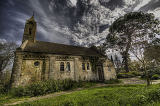
WAdullam is an ancient ruin, formerly known by the Arabic appellation ʿAīd el Mâ, built upon a hilltop overlooking the Elah Valley, straddling the Green Line between Israel and the West Bank. In the late 19th century, the town was still in ruins. The hilltop ruin is also known by the name Khurbet esh-Sheikh Madkour, named after Madkour, one of the sons of the Sultan Beder, for whom is built a shrine (wely) and formerly called by its inhabitants Wely Madkour. The hilltop is mostly flat, with cisterns carved into the rock. The remains of stone structures which once stood there can still be seen. Sedimentary layers of ruins from the old Canaanite and Israelite eras, mostly potsherds, are noticeable everywhere, although olive groves now grow atop of this hill, enclosed within stone hedges. The villages of Aderet, Aviezer and Khirbet al-Deir are located nearby. The ruin lies about 3 kilometers south of Moshav Neve Michael. The area around ancient Adullam between Bet Shemesh and Bet Guvrin was established in 1957 as "Adullam Region" and settled since then.
 W
WAdullam Grove Nature Reserve is a nature reserve in central Israel, south of Beit Shemesh, managed by the Israel Nature and National Parks Protection Authority.
 W
WTel Afek,, also spelled Aphek and Afeq, is an archaeological site located in the coastal hinterland of the Ein Afek Nature Reserve, east of Kiryat Bialik, Israel. It is also known as Tel Kurdani.
 W
WAlonei Abba is a moshav shitufi, or semi-cooperative village, in northern Israel. It was founded in 1948 on the site of the historical Palestinian village of Umm el Amad, later the German Protestant colony of Waldheim.
 W
WAlonei Yitzhak is a youth village in northern Israel. Located near Binyamina, it falls under the jurisdiction of Menashe Regional Council. In 2019 it had a population of 309.
 W
WNahal Amud, also known as the Wadi al-Amud, is a stream in the Upper Galilee region of Israel that flows into the Sea of Galilee.
 W
WTel Anafa is an archaeological site and nature reserve in the Upper Galilee, Israel.
 W
WMount Arbel is a mountain in The Lower Galilee near Tiberias in Israel, with high cliffs, views of Mount Hermon in the Golan Heights, trails to a cave-fortress, and ruins of an ancient synagogue. Mt. Arbel sits across from Mount Nitai; their cliffs were created as a result of the Jordan Rift Valley and the geological faults that produced the valleys.
 W
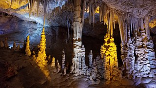
WAvshalom Cave, also known as Soreq Cave or Stalactites Cave, is a 5,000 m2 cave on the western side of Mt. Ye'ela, in the Judean hills in Israel, unique for its dense concentration of stalactites and other cave formations.
 W
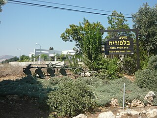
WBalfouria is a moshav in northern Israel, south of Nazareth. Located near Afula, it falls under the jurisdiction of Jezreel Valley Regional Council. As of 2019 it had a population of 528.
 W
WNahal Betzet, Arabic: Wadi Karkara, is a once-perennial and now intermittent stream in the Upper Galilee, Israel. Most of it is part of the nature reserve named for the stream.
 W
WBitan Aharon is a moshav in central Israel. Located in the Sharon plain between Hadera and Netanya, it falls under the jurisdiction of Hefer Valley Regional Council. In 2019 it had a population of 152.
 W
WBnei Zion is a moshav in central Israel. Located in the Sharon plain around four and a half kilometres north of Ra'anana, it falls under the jurisdiction of Hof HaSharon Regional Council. In 2019 it had a population of 1,370.
 W
WCarmel Hai-Bar Nature Reserve is a 1,500-acre (610 ha) breeding and acclimation center administered by the Israel Nature Reserves and National Parks Authority, situated in the Carmel mountains in northwestern Israel, within the larger Mount Carmel National Park. The Carmel Hai-Bar is the Mediterranean climate counterpart of the Yotvata Hai-Bar Nature Reserve which operates in the desert.
 W
WEilat's Coral Beach Nature Reserve and Conservation area is a nature reserve and national park in the Red Sea, near the city Eilat in Israel. It covers 1.2 kilometers of shore, and is the northernmost shallow water coral reef in the world. It is popular for diving and research, and was founded by the Israel Nature and Parks Authority. At the southernmost point of the nature reserve there is the Coral World Underwater Observatory, the largest public aquarium in the Middle East. It was listed as one of the New York Times Places to Go in 2019.
 W
WDan is a city mentioned in the Hebrew Bible, described as the northernmost city of the Kingdom of Israel, and belonging to the tribe of Dan. The city is identified with a tell located in northern Israel known as Tel Dan in Hebrew, or Tell el-Qadi.
 W
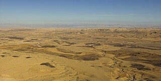
WThe Eilat Mountains are a mountain range within the southern Negev in southern Israel.
WEilat's Coral Beach Nature Reserve and Conservation area is a nature reserve and national park in the Red Sea, near the city Eilat in Israel. It covers 1.2 kilometers of shore, and is the northernmost shallow water coral reef in the world. It is popular for diving and research, and was founded by the Israel Nature and Parks Authority. At the southernmost point of the nature reserve there is the Coral World Underwater Observatory, the largest public aquarium in the Middle East. It was listed as one of the New York Times Places to Go in 2019.
 W
WEin Gedi, literally "spring of the kid " is an oasis and a nature reserve in Israel, located west of the Dead Sea, near Masada and the Qumran Caves. Ein Gedi was listed in 2016 as one of the most popular nature sites in the country. The site attracts about one million visitors a year.
 W
WMount Gilboa, sometimes called the Mountains of Gelboe, in Arabic: جبل جلبوع Jebel Faqqua, is a mountain range overlooking the Jezreel Valley in Israel to the north.
 W
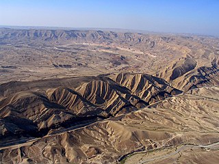
WHaMakhtesh HaGadol is a makhtesh, a geological erosional landform of Israel's Negev desert. It measures 5 x 10 km.
 W
WThe Hasbani River or Snir Stream, is the major tributary of the Jordan River. Local natives in the mid-19th century knew the river as the Upper Jordan.
 W
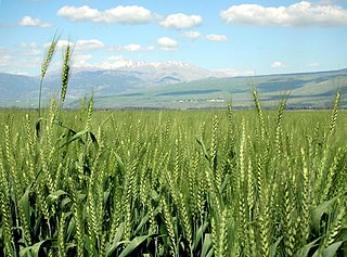
WThe Hula Valley is an agricultural region in northern Israel with abundant fresh water, which used to be Lake Hula, prior to its draining. It is a major stopover for birds migrating along the Syrian-African Rift Valley between Africa, Europe, and Asia.
 W
WHurshat Tal is a national park and nature reserve in the Northern District of Israel. In 1968, 765 dunams were declared national park lands and 107 dunams were declared a nature reserve.
 W
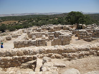
WHorvat 'Ethri, Hebrew for "Ethri Ruins", Arabic name: Umm Suweid, is a sprawling archaeological site that features the remains of a now partially restored Jewish village which dates back to the Second Temple period. The site sits upon an elevation of 406 metres (1,332 ft) above sea level, wherein are preserved an ancient synagogue, wine presses, cisterns, ritual baths and stone ossuaries, as well as an underground system of public hiding places. The site is located in modern-day Israel and is situated in the Judean Hills, southeast of Bet Shemesh, within the Adullam-France Park – c. 35 kilometers (22 mi) southwest of Jerusalem, 5 kilometers (3.1 mi) southeast of the Elah Valley and 8 kilometers (5.0 mi) northeast of Beth Guvrin. The site stands out among other archaeological sites because of its formidable defensive walls, with massive stones, which led Israeli archaeologist, Boaz Zissu, to believe that it may have been one of the fifty strongholds in Judea destroyed by Hadrian during the Bar Kokhba revolt.
 W
WNahal Ayun, sometimes spelled Nahal Iyyon, in Arabic: براغيث Bureighit, or in full Nahr Bareighit, is a perennial stream and a tributary of the Jordan River. The stream originates from two springs in the Marjayoun valley in southern Lebanon, runs southward for seven kilometers through various irrigation ditches, then flows into Israel near Metulla, where it continues through the Hula Valley in the Galilee Panhandle until emptying in the Hasbani River just before it reaches the Jordan River.
 W
WKerem Ben Zimra is a moshav in northern Israel. Located near Safed in the Upper Galilee, it falls under the jurisdiction of Merom HaGalil Regional Council. In 2019 it had a population of 526.
 W
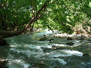
WNahal Kziv or the Horn Valley is a 39-kilometer long perennial stream in the Upper Galilee, Israel. During the winter, rainfall fills the channel, and springs along the riverbed add to the flow. Currently, Mekorot pumps the water of the river's principal spring, Ein Ziv, and supplies it to the residents of the Western Galilee, making the channel between Ein Ziv and Ein Tamir an intermittent stream. On the southern ridge overlooking the valley sits a 12th-century Crusader castle, Montfort, the old headquarters of the Teutonic Order in the Holy Land.
 W
WA makhtesh (Hebrew: מַכְתֵּשׁ, Hebrew plural: מַכְתְּשִׁים is a geological landform considered typical for the Negev desert of Israel and the Sinai peninsula of Egypt. A makhtesh has steep walls of resistant rock surrounding a deep closed valley, which is usually drained by a single wadi. The valleys have limited vegetation and soil, containing a variety of different colored rocks and diverse fauna and flora. The best known and largest makhtesh is Makhtesh Ramon.
 W
WMaoz Haim is a kibbutz in Israel. Located adjacent to the Jordan River in the Beit She'an valley and falls under the jurisdiction of Valley of Springs Regional Council. In 2019 it had a population of 469. Aside from agriculture, the kibbutz also has a plastics factory, "Poliraz". Maoz Haim was built on what was the traditional village land of Al-Ghazzawiyya.
 W
WMount Meron is a mountain in the Upper Galilee region of Israel. It has special significance in Jewish religious tradition and parts of it have been declared a nature reserve.
 W
WMount Carmel National Park is Israel's largest national park, extending over most of the Carmel mountain range and containing over 10,000 hectares of pine, eucalyptus, and cypress forest. The park has numerous bicycle and walking paths, dedicated nature reserves, and over 250 archaeological sites of prehistoric human habitations.
 W
WThe Caves of Nahal Me’arot / Wadi el-Mughara, named here by the Hebrew and Arabic name of the valley where they are located, are a UNESCO Site of Human Evolution in the Carmel mountain range near Haifa in northern Israel.
 W
WNeot Kedumim, the Biblical Landscape Reserve in Israel is a Biblical garden and nature preserve located near Modi'in, midway between Jerusalem and Tel Aviv, Israel.
 W
WThe Pa'ar Cave is a karstic sinkhole in the Upper Galilee, Israel. The cave is located between the Adir peak, and kibbutz Sasa. The sinkhole channels the water flowing from the Pa'ar stream to groundwater level.
 W
WNahal Poleg is a stream in the Sharon plain in Israel that empties into the Mediterranean Sea between Netanya and the Wingate Institute.
 W
WRosh HaNikra or Hanikra is a geologic formation on the border between Israel and Lebanon, located on the coast of the Mediterranean Sea, in the Western Galilee. It is a white chalk cliff face which opens up into spectacular grottos.
 W
WShimron is a nature reserve in Northern Israel.
 W
WNahal Taninim or Wadi az-Zarka is a river in Israel near the Arab town Jisr az-Zarqa, originating near Ramot Menashe and emptying into the Mediterranean Sea south of Ma'agan Michael. It marks the southern limit of the Hof HaCarmel, or Carmel Coastal Plain region.
 W
WNahal Tavor, lit. Tabor Stream, is an intermittent stream in the Lower Galilee, Israel.
 W
WTel Yitzhak is a kibbutz in central Israel. Located in the coastal plain to the south-east of Netanya, it falls under the jurisdiction of Hof HaSharon Regional Council. In 2019 it had a population of 1,021.
 W
WThe Timna Valley (תִּמְנָע) is located in southern Israel in the southwestern Arava/Arabah, approximately 30 kilometres (19 mi) north of the Gulf of Aqaba and the city of Eilat. The area is rich in copper ore and has been mined since the 5th millennium BCE. There is controversy whether the mines were active during the biblical united Kingdom of Israel and its second ruler, King Solomon.
 W
WTur Shimon or Horvat Tura, the Hebraized form of Khirbet et-Tantura, so-called after the shape of the hill, is an archaeological site in Nahal Sorek. Ancient Tur Shimon, mentioned twice in classical Hebrew literature, has been tentatively identified by archaeologist Boaz Zissu with Khirbet Sammunieh, based on a comparison of the name Tur Shimon with two given Arabic names. In maps of the British Mandate period, the ruin is also named Khirbet et-Tantura. Archaeologists have proposed that this name embodies the Aramaic concept of "mountain" = Tur. In older PEF maps of Conder and Kitchener, the name of the ruin is given as Sammunieh, a name reminiscent of the Hebrew name Shimon. A riverine brook that flows immediately beneath the mountain has also the appellation of Wadi Ismaʻin, thought too to be a corruption of the name Shimon.
 W
WUdim is a moshav in central Israel. Located near Netanya, it falls under the jurisdiction of Hof HaSharon Regional Council. In 2019 it had a population of 1,379.
 W
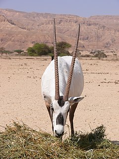
WThe Yotvata Hai-Bar Nature Reserve is a 3,000-acre (12 km2) breeding and reacclimation center administered by the Israel Nature Reserves & National Parks Authority, situated in the Southern Arabah near Yotvata.