 W
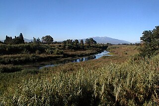
WThe Adour is a river in southwestern France. It rises in High-Bigorre (Pyrenees), in the commune of Aspin-Aure, and flows into the Atlantic Ocean near Bayonne. It is 308.3 kilometres (191.6 mi) long, of which the uppermost ca. 11 kilometres (6.8 mi) is known as the Adour de Payolle. At its final stretch, i.e. on its way through Bayonne and a short extent upstream, the river draws the border between the Northern Basque Country and Landes regions.
 W
WThe Agly is a river in southern France. It is 79.9 km (49.6 mi) long. Its source is in the hills of the Corbières Massif, near Camps-sur-l'Agly. It flows through Saint-Paul-de-Fenouillet, Estagel, Rivesaltes and Saint-Laurent-de-la-Salanque before it flows into the Mediterranean Sea near Le Barcarès.
 W
WThe Agout is a 194.4-kilometre (120.8 mi) long river in south-western France. It is a left tributary of the Tarn. Its source is in the southern Massif Central, in the Haut-Languedoc Regional Nature Park. It flows generally west through the following department and towns:Hérault: La Salvetat-sur-Agout Tarn: Brassac, Castres, Lavaur, Saint-Sulpice
 W
WThe Aiguillon is a river in southern France, a tributary of the Cèze. It is 22 km (14 mi) long. It is the departments of Gard, in the Occitanie region. The source of the Aiguillon is on Mont Bouquet, west of Lussan. It flows through Lussan, Les Concluses, Goussargues where it joined by the Merderis and it flows into the Cèze upstream of La Roque-sur-Cèze.
 W
WThe Allier is a river in central France. It is a left tributary of the Loire. Its source is in the Massif Central, in the Lozère department, east of Mende. It flows generally north. It joins the Loire west of the city of Nevers. It is 421 km (262 mi) long, and has a drainage basin of 14,350 km2 (5,540 sq mi).
 W
WCol d'Ares or Coll d'Ares is a mountain pass in the Pyrenees on the border between France and Spain.
 W
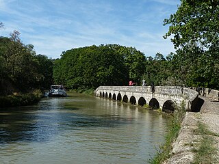
WArgens Lock is a single chamber lock on the Canal du Midi. It lies east of the small town of Argens in the Aude region of Languedoc, France. The adjacent locks are Fonserannes Lock 53,868 metres to the east and Pechlaurier Lock 2485 metres to the west.
 W
WThe Argent-Double Aqueduct is one of several aqueducts on the Canal du Midi. The Argent-Double stream is culverted under the canal at La Redorte.
 W
WThe Ariège is a 163 km long river in southern France, right tributary of the Garonne. Its source is in the Pyrenees, where it forms part of the border with Andorra. It flows north through the following towns in two departments:In Ariège: Ax-les-Thermes, Les Cabannes, Tarascon-sur-Ariège, Montgaillard, Foix, Varilhes, Pamiers, Saverdun. In Haute-Garonne: Cintegabelle, Auterive.
 W
WThe Arrats is a 162 km long river in southern France, left tributary of the Garonne. Its source is in the northern foothills of the Pyrenees, near Sariac-Magnoac. It flows north through the following départements and towns:Hautes-Pyrénées Gers: Castelnau-Barbarens, Aubiet, Mauvezin, Saint-Clar Tarn-et-Garonne: Saint-Loup
 W
WThe Aveyron is a 291 km long river in southern France, right tributary of the Tarn. It rises in the southern Massif Central, near Sévérac-le-Château.
 W
WThe Baïse is a 188-kilometre (117 mi) long river in south-western France, left tributary of the Garonne. Its source is in the foothills of the Pyrenees, near Lannemezan. It flows north through the following départements and towns:Hautes-Pyrénées: Lannemezan, Trie-sur-Baïse Gers: Mirande, Castéra-Verduzan, Valence-sur-Baïse, Condom Lot-et-Garonne: Nérac, Lavardac
 W
WThe Bouès is a right tributary of the Arros, at the eastern end of the basin of the Adour, in the Southwest of France. It is 63 km (39 mi) long.
 W
WThe Boulzane is a river in the south of France. It is 33.9 km (21.1 mi) long. Its source is in Aude, near Montfort-sur-Boulzane. It flows through Lapradelle-Puilaurens, Gincla, Caudiès-de-Fenouillèdes before it empties into the Agly near Saint-Paul-de-Fenouillet.
 W
WThe Cady is a 19 km long river in the Catalan Pyrenees of southern France, near the border with eastern Spain. It rises on the slopes of the Canigou, flows through the Cadí cirque where it feeds the Cadí Lakes, and continues northward to Villefranche-de-Conflent where it empties into the Têt.
 W
WThe Causses are a group of limestone plateaus in the Massif Central. They are bordered to the north-west by the Limousin and the Périgord uplands, and to the east by the Aubrac and the Cévennes. Large river gorges cut through the plateau, such as the Tarn, Dourbie, Jonte, Lot and Aveyron. Causse is an Occitan word meaning "limestone plateau".
 W
WThe Cèze is a French river, a right tributary of the Rhone. It runs through the departments of Lozère and Gard in the Occitanie region. It is 128 km (80 mi) long. Its source is in the Cévennes mountains, near Saint-André-Capcèze. It flows through Bessèges, Saint-Ambroix, Bagnols-sur-Cèze, and it flows into the Rhone at Codolet, southwest of Orange.
 W
WThe Col du Perthus is a mountain pass of the Pyrenees on the France–Spain border, between the Pyrénées-Orientales in Languedoc-Roussillon, Midi-Pyrénées and the Province of Girona in Catalonia.
 W
WThe Désix is a river in the south of France. It is 32.3 km (20.1 mi) long. Its source is in Fenolheda, near Aussières peak. It flows through Rabouillet, Sournia, Pézilla-de-Conflent, Felluns and Trilla before it empties into the Agly near Ansignan.
 W
WThe Dourbie is a 72 km (45 mi) long river in southern France. It is a left tributary of the Tarn. Its source is north of Le Vigan, in the Cévennes. It flows generally west through the following departments and towns:Gard: Dourbies Aveyron: Saint-Jean-du-Bruel, Nant
 W
WThe Douze is the right source river of the Midouze, in the Landes, in the southwest of France. It is 123.5 km (76.7 mi) long.
 W
WThe Ecluse Saint-Pierre is one of two locks on the Canal de Brienne. Also known as Garonne lock, in French: Ecluse de Garonne.
 W
WThe Gave de Pau is a river of south-western France. It takes its name from the city of Pau, through which it flows. The river is 181.3 kilometres (112.7 mi) long, and its source is at the Cirque de Gavarnie in the Pyrenees mountains. The Gave de Pau joins the Gave d'Oloron in Peyrehorade to form the about 9-kilometre (6 mi) long Gaves réunis, which is a left tributary of the Adour. The Gaves réunis is often considered to be part of the Gave de Pau.
 W
WThe Gélise is a tributary of the river Baïse in Gascony, southwestern France. It is 92.0 km (57.2 mi) long.
 W
WThe Gers is a 175-kilometre (109 mi) long river in southern France, left tributary of the Garonne.
 W
WThe Gimone is a 136-kilometre (85 mi) river in south-western France, left tributary of the Garonne. Its source is in the foothills of the Pyrenees, near Lannemezan. It flows north through the following départements and towns:Hautes-Pyrénées Gers: Saramon, Gimont Tarn-et-Garonne: Beaumont-de-Lomagne
 W
WThe Hérault is a river in southern France. Its length is 147.6 kilometres (91.7 mi). Its source is on the slopes of Mont Aigoual in the Cévennes mountains. It reaches the Mediterranean Sea near Agde.
 W
WThe Hers-Mort is a 89.3-kilometre (55.5 mi) long river in southern France, a right-bank tributary of the Garonne. Its average flow rate is 4 cubic metres per second (140 cu ft/s). The Hers-Mort rises in the Lauragais region, near the village Fonters-du-Razès, in the Aude department. It flows northwest through the following departments and towns:Aude: Payra-sur-l'Hers, Salles-sur-l'Hers Haute-Garonne: Villefranche-de-Lauragais, Baziège, Toulouse, Saint-Jory
 W
WThe Hers-Vif, also named Grand Hers or simply Hers, is a 135-kilometre (84 mi) long river in southern France, right tributary of the Ariège.
 W
WHomps Lock is a single chamber lock on the Canal du Midi. It lies east of the small town of Homps in the Aude region of Languedoc, France. The adjacent locks are Ognon Lock 689 metres to the east and Jouarres Lock 3688 metres to the west.
 W
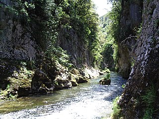
WThe Jonte is a 38.6 km (24.0 mi) river in southern France. It flows through the departments of Lozère and Aveyron. It is a tributary of the Tarn, which it joins in Le Rozier.
 W
WPic de Madrès is a peak in the French Pyrenees, in the Aude department, Languedoc-Roussillon. It has an elevation of 2,469 m.
 W
WMargeride is a mountainous region of France, situated in the Massif Central, inside the départements of Cantal, Haute-Loire and Lozère.
 W
WThe Montagne Noire is a mountain range in central southern France. It is located at the southwestern end of the Massif Central in the border area of the Tarn, Hérault and Aude departments. Its highest point is the Pic de Nore at 1,210 metres (3,970 ft).
 W
WNégra Lock is a single chamber lock on the Canal du Midi near the village of Villefranche-de-Lauragais in Languedoc, France. There is a small chapel at the lock and also a small red-brick aqueduct which carries the canal over the Thésauque, a tributary of the Hers.
 W
WOgnon Lock is a double chamber lock on the Canal du Midi in the Aude region of Languedoc, France. The adjacent locks are Pechlaurier Lock 2726 metres to the east and Homps Lock 689 metres to the west.
 W
WHaut-Languedoc Regional Nature Park is a regional natural park in the south of the Massif Central within the Aveyron, Hérault, and Tarn departments of France. These areas are considered the Haut-Languedoc, compared to the Bas-Languedoc.
WThe pic de Nore at 1211 metres is the highest point in the Montagne Noire, on the border of the Aude and Tarn departments, near to the Parc naturel régional du Haut-Languedoc in southern France. The Arnette and Clamoux rivers both have their sources on the slopes.
 W
WThe Pique is a 33 km long river in southern France, left tributary of the Garonne. Its source is in the Pyrenees, on the north side of the Port de Venasque mountain pass. It flows generally northward, entirely within the Haute-Garonne département. It passes through the resort town Bagnères-de-Luchon and Cierp-Gaud. It flows into the Garonne in Chaum.
 W
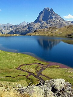
WThe Pyrénées National Park is a National Park of France located within the French departments of Hautes-Pyrénées and Pyrénées-Atlantiques.
 W
WThe Save is a 144 km long river in southern France, left tributary of the Garonne. Its source is in the northern foothills of the Pyrenees, south of Lannemezan. It flows north-east through the following départements and cities:Hautes-Pyrénées. Haute-Garonne: Grenade, L'Isle-en-Dodon. Gers: L'Isle-Jourdain.
 W
WPic de Serra Gallinera is a mountain of Pyrénées-Orientales, Occitanie, France. Located in the Pyrenees, it has an elevation of 2,663 metres (8,737 ft) above sea level.
 W
WThe Viaur is a 168-kilometre-long (104 mi) river in south-western France. It is a left tributary of the Aveyron. Its source is in the southern Massif Central, north of Millau. It flows generally west through the following departments and towns:Aveyron: Pont-de-Salars Tarn: Pampelonne Tarn-et-Garonne: Laguépie
 W
WThe Vidourle is a 95.0 km (59.0 mi) river in southern France that flows into the Mediterranean Sea in Le Grau-du-Roi. Its source is in the Cévennes mountains, northwest of Saint-Hippolyte-du-Fort, at Saint-Roman-de-Codières. It flows generally southeast. At Gallargues-le-Montueux, it was crossed by the old Roman road Via Domitia with the now ruined Roman bridge Pont Ambroix.
 W
WThe Vis is a 57.8-kilometre-long (35.9 mi) river in south-central France, in the Occitanie administrative region. It is a right tributary of the Hérault. Its source is in the Cévennes, near the village of Alzon. It flows between the Causse du Larzac and the Causse de Blandas into the Hérault and Gard departments. The Vis flows into the Hérault near Ganges.
 W
WThe Volp is a 40-kilometre-long (25 mi) river of southwestern France. It is a right tributary of the Garonne, which it joins upstream of Cazères, Haute-Garonne. A flood in 1993 ruined a marginal amount of cropland.