 W
WThe following is a list of Toll Roads in the Republic of Ireland. Ireland has 173 kilometres (107 mi) of toll roads, bridges and tunnels.
 W
WThe island of Ireland, comprising Northern Ireland and the Republic of Ireland, has an extensive network of tens of thousands of kilometres of public roads, usually surfaced. These roads have been developed and modernised over centuries, from trackways suitable only for walkers and horses, to surfaced roads including modern motorways. The major routes were established before Irish independence and consequently take little cognisance of the border other than a change of identification number and street furniture. Northern Ireland has had motorways since 1962, and has a well-developed network of primary, secondary and local routes. The Republic started work on its motorway network in the early 1980s; and historically, the road network there was once somewhat less well developed. However, the Celtic Tiger economic boom and an influx of European Union structural funding, saw national roads and regional roads in the Republic come up to international standard quite quickly. In the mid-1990s, for example, the Republic went from having only a few short sections of motorway to a network of motorways, dual carriageways and other improvements on most major routes as part of a National Development Plan. Road construction in Northern Ireland now tends to proceed at a slower pace than in the Republic, although a number of important bypasses and upgrades to dual carriageway have recently been completed or are about to begin.
 W
WThe main roads in Northern Ireland, which connect well with those in the south, are signed "M"/"A"/"B" as in Great Britain. Whereas the roads in Great Britain are numbered according to a zonal system, there is no available explanation for the allocation of road numbers in Northern Ireland, though their numbering is separate from the system in England, Scotland and Wales.
 W
WThe A1 is a major route in Northern Ireland. It runs from Belfast via Lisburn and Banbridge to the border with the Republic of Ireland south of Newry, from where the road continues to Dublin, becoming the N1 road and M1 motorway. Between Sprucefield and Carrickcarnan the road forms part of the European route E01.
 W
WThe A22 is a road in County Down, in Northern Ireland. Its route starts in Dundonald and runs to Comber, forming the main transport corridor connecting Belfast and Comber, a commuter town situated 8 miles outside of the city. After bypassing Comber town itself, the route continues along the eastern shores of, though not directly adjacent to, Strangford Lough. The route passes through Lisbane, Balloo, and Killyleagh, terminating in Downpatrick.
 W
WThe A23 is an 8.7-mile-long (14.0 km) road in County Down, in Northern Ireland. The route starts in near the Short Strand district in east Belfast and follows the Castlereagh Road through the southeastern suburbs of the city. Upon passing through the A55 Outer Ring Road, the A23 becomes the Ballygowan Road. It passes through the Castlereagh Hills and finishes in the village of Ballygowan at a roundabout with the A21.
 W
WThe A25 is the name given to the sections of the main route connecting Strangford with Castleblayney that lie in Northern Ireland. It is a road of regional importance, serving much of south Armagh and south Down. The road commences in the village of Strangford, on the shores of Strangford Lough, from which the Portaferry - Strangford Ferry service transports vehicles to Portaferry on the Ards peninsula. The entirety of the route is 61.2 miles, of which 54.5 miles are located north of the border, forming the A25 - the remaining 6.7 miles form the R182 in the Republic of Ireland.
 W
WThe A32 is a route in Northern Ireland connecting Omagh, County Tyrone and Swanlinbar, County Cavan. The road passes through Dromore in Tyrone and the Fermanagh towns of Irvinestown and Enniskillen.
 W
WThe A34 is a road in County Fermanagh in Northern Ireland. The route carries traffic from the A4 in Maguiresbridge via Lisnaskea and Newtownbutler to Clones in County Monaghan.
 W
WThe A42 is an east-west route in Northern Ireland. It starts in Maghera in County Londonderry, from where it goes in the direction of Carnlough on the shores of the North Channel of the Irish Sea, at the foot of the Glens of Antrim. The road goes through Gulladuff and Clady, as well as Portglenone, Ahoghill, Ballymena Broughshane and The Sheddings.
 W
WThe A50 is a road in counties Armagh and Down in Northern Ireland. It starts in the town of Portadown and continues through Gilford, Lawrencetown, Banbridge, Katebridge, Moneyslane, Ballyward and Castlewellan, before arriving in the seaside town of Newcastle on the Irish Sea, located at the foot of Slieve Donard.
 W
WEuropean route E16 is the designation of a main west-east road through Northern Ireland, Scotland, Norway and Sweden, from Derry to Gävle, via Belfast, Glasgow, Edinburgh, previously by ferry to Bergen, Voss, through the Gudvanga Tunnel and the Lærdal Tunnel, Lærdal, over Filefjell to Fagernes, Hønefoss, Gardermoen and Kongsvinger. In Sweden it passes Malung, Falun and ends in Gävle.
 W
WEuropean route E18 runs from Craigavon in Northern Ireland to Saint Petersburg in Russia, passing through Scotland, England, Norway, Sweden, and Finland. It is about 1,890 kilometres in length.
 W
WThe A2 is a major road in Northern Ireland, a considerable length of which is often referred to the Antrim Coast Road because much of it follows the scenic coastline of County Antrim; other parts of the road follow the coasts in Counties Down and Londonderry.
 W
WThe A20 is a road in County Down in Northern Ireland. It runs from Belfast to Newtownards and on to Portaferry.
 W
WThe A21 is a road in County Down in Northern Ireland. The route commences in Bangor, passing through Newtownards, Comber, and Ballygowan, and finishes on the northern outskirts of Ballynahinch.
 W
WThe A24 is a major road in Northern Ireland; running from Belfast, through Carryduff and Ballynahinch to Clough, near Newcastle where it meets the A2.
 W
WThe A26 is a road in Northern Ireland. It travels in a north–south direction from Coleraine, County Londonderry to Banbridge, County Down.
 W
WThe A29 is a major road in Northern Ireland; it is mostly a single carriageway and goes through a number of main towns and connects in several places to other major roads.
 W
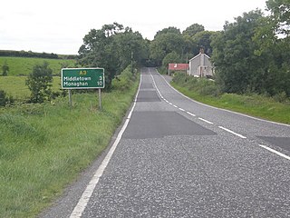
WThe A3 is a major road in Northern Ireland. It travels through County Antrim, County Down, County Armagh and parts of southern County Fermanagh.
 W
WThe A36 is a road in Northern Ireland. It travels through County Antrim, connecting the large towns of Ballymena and Larne.
 W
WThe A4 is a major east-west road in Northern Ireland. It travels for 69.2 miles from Portadown to Belcoo through County Armagh, County Tyrone and County Fermanagh.
 W
WThe A46 is a road in County Fermanagh, in Northern Ireland. It forms part of the route from Dublin to Ballyshannon. It stretches 23.6 miles from Enniskillen to Belleek along the southwestern shoreline of Lower Lough Erne.
 W
W[[File:A5 road (Ireland).jpg|thumb|268px|
 W
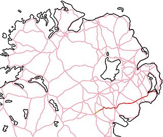
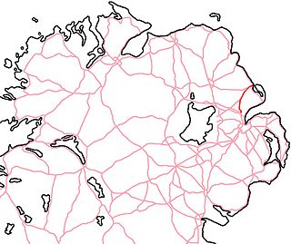
WThe A509 is a road in Northern Ireland. It travels through County Fermanagh and continues to Cavan and Dublin in the Republic of Ireland as the N3.
 W
WThe A6 road in Northern Ireland runs for 71.4 miles (114.9km) from Belfast to Derry, via County Antrim and County Londonderry. From Belfast to Randalstown the route has been superseded by a motorway. Mostly single carriageway, there are sections of dual carriageway in Antrim town centre and from Randalstown to Toome, including the Toome bypass. In urban and suburban districts of Belfast and Derry the route is single carriageway with 4 lanes. In rural parts, there are numerous climbing lanes along the route. The A6 is one of Northern Ireland's most important arterial routes, as the road runs between its two largest cities and urban areas. Between Randalstown and Derry the road forms part of European route E16.
 W
WIn Northern Ireland, the A7 is a major trunk road running 16 miles (26 km) from Downpatrick, through Crossgar and Saintfield, to Carryduff. Here the A7 joins the A24 at an at-grade roundabout, and continues to Belfast.
 W
WThe A8 in Northern Ireland is a 26.1 km route connecting the city of Belfast with the harbour town of Larne. One of the busiest routes in the region, the road forms part of the unsigned European routes E01 and E18.
 W
WThe A515 Skeoge Link is a road in Northern Ireland which was designed to complete the route between Foyle Bridge in County Londonderry and Donegal. It is part of a larger project to link County Donegal with Belfast. The total construction cost was £5 million.
 W
WThe A40 links Derry in the North West of Northern Ireland to Raphoe in County Donegal.
 W
WThe A47 road runs from Kesh to Belleek along the north shore of Lower Lough Erne. The A47 commences from Letterkeen, a townland north of Kesh in County Fermanagh, and heads due west near the shores of Lower Lough Erne and over the eastern causeway and bridge onto Boa Island.
 W
WThe A55 road forms Belfast's outer-ring road.
 W
WThe B52 road connects the A4 road in the village of Belcoo in County Fermanagh above the village green overlooking the shores of Lough MacNean. The road crosses the dismantled Sligo, Leitrim and Northern Counties Railway with the former station and closed level crossing. On leaving Belcoo the road heads westwards to Holywell with the shore of Lough MacNean on the left over the fields. The road continues to Garrison, connecting with the B53 and onwards to Drumlisaleen and connecting at Corry Cross Roads with the A46 in Belleek on the border of County Donegal and County Fermanagh. Corry Cross Roads is the most westerly numbered road junction in the UK.
 W
WBoreen or bohereen is a country lane, or narrow, frequently unpaved, rural road in Ireland.
 W
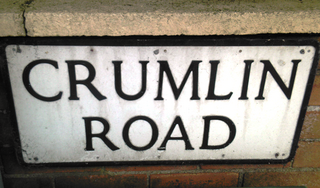
WThe Crumlin Road is a main road in north-west Belfast, Northern Ireland. The road runs from north of Belfast City Centre for about four miles to the outskirts of the city. It also forms part of the longer A52 road which leads out of Belfast to the town of Crumlin(from Irish: Cromghlinn, meaning "crooked glen"). The lower section of the road houses a number of historic buildings, including the city's former law courts and prison, whilst the road encompasses several large housing areas, including Ardoyne, Ballysillan and Ligoniel(from Irish: Lag an Aoil, meaning "hollow of the lime")..
 W
WThe Donegall Road is a residential area and road traffic thoroughfare that runs from Shaftesbury Square on what was once called the "Golden Mile" to the Falls Road in west Belfast. The road is bisected by the Westlink – M1 motorway. The largest section of the road, east of the Broadway junction with the Westlink, has a community which self-identifies as predominantly Protestant while the community on the other side of the Westlink – M1 motorway self-identifies as predominantly Catholic.
 W
WFalls Road is the main road through west Belfast, Northern Ireland, running from Divis Street in Belfast city centre to Andersonstown in the suburbs. The name has been synonymous for at least a century and a half with the Catholic community in the city. The road is usually referred to as the Falls Road, rather than as Falls Road. It is known as the Faas Raa in Ulster-Scots.
 W
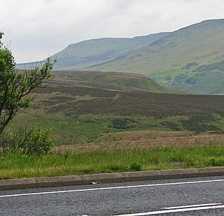
WThe Glenshane Pass is a major mountain pass cutting through the Sperrin Mountains in County Londonderry, Northern Ireland. It is in the townland of Glenshane Pass on the main Derry to Belfast route, the A6.
 W
WLisburn Road is a main arterial route linking Belfast and Lisburn, Northern Ireland.
 W
WThe Malone Road is a radial road in Belfast, Northern Ireland, leading from the university quarter southwards to the affluent suburbs of Malone and Upper Malone, each a separate electoral ward. The road runs parallel to the Lisburn Road and is linked by over a dozen side streets, while at its northern end, the Stranmillis Road rejoins the Malone Road to form University Road, which in turn joins with the Lisburn Road to become Bradbury Place. Most of the road is in the BT9 postcode district.
 W
WThe Ormeau Road is a road in south Belfast, the largest city in Northern Ireland. Ormeau Park is adjacent to it. It forms part of the A24.
 W
WThe Shankill Road is one of the main roads leading through west Belfast, in Northern Ireland. It runs through the working-class, predominantly loyalist, area known as the Shankill.
 W
WShaw's Road is a road in west Belfast, Northern Ireland, connecting the Andersonstown Road with the Glen Road.
 W
WThe Shore Road is a major arterial route and area of housing and commerce that runs through north Belfast and Newtownabbey in Northern Ireland. It forms part of the A2 road, a traffic route which links Belfast to the County Antrim coast.
 W
WThe Springfield Road is a residential area and road traffic thoroughfare adjacent to the Falls Road in west Belfast. The local population is predominantly Irish nationalist and republican. Parts of the road form an interface area with the neighbouring Ulster loyalist areas of the Greater Shankill and it was the site of much activity during the Troubles. The Springfield Road includes the Ballymurphy and New Barnsley districts and is overlooked by Black Mountain and Divis.
 W
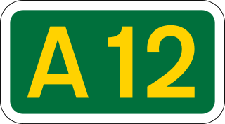
WThe Westlink road in Belfast, Northern Ireland is a dual carriageway throughpass, designated the A12, connecting the M1 to the M2 and M3 motorways which run south, north and east of the city, respectively. The road forms part of European route E01.