 W
WAomori University is a private university located in the city of Aomori, Japan, founded in 1968. The university has three major areas of study: business administration, sociology, and software and information technology.
 W
WAsamushi Onsen (浅虫温泉) is the site of a hot spring, on the eastern edge of the city of Aomori in Aomori Prefecture, Japan. It was developed as the downtown beside the onsen town and is sometimes known as "Atami in Tohoku" after the famous Atami Onsen in Shizuoka, central Japan.
 W
WAseishigawa Dam is a multi-purpose dam on the Aseishi River, a tributary of the Iwaki River in the city of Kuroishi in Aomori Prefecture, Japan. Construction began on the dam in 1971, and it was completed in 1988.
 W
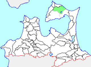
WCape Shiriya is a headland on the northerneastern point of the island of Honshu in Japan. It is located within the borders of the town of Higashidōri, Aomori in northern Shimokita Peninsula, and is part of the Shimokita Hantō Quasi-National Park. The cape is on the border of Tsugaru Strait separating Honshu from Hokkaido, and the Pacific Ocean.
 W
WCape Tappi , otherwise known as Cape Tappimi , is a headland on the northernwestern point of the island of Honshu in Japan. It is located on the northern tip of the Tsugaru Peninsula within the borders of the town of Sotogahama in Aomori Prefecture. Much of the cape is also a part of the Tsugaru Quasi-National Park. The cape marks the western limit of the Tsugaru Strait, separating it from the Sea of Japan. The area is known for its almost constant strong winds.
 W
WFukuchi was a village located in Sannohe District in northern Aomori Prefecture, Japan.
 W
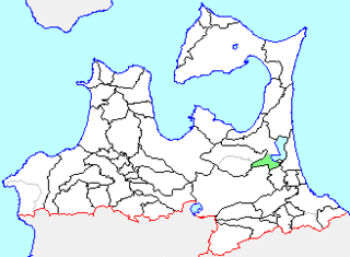
WThe Hachinohe mine is a limestone quarry in the city of Hachinohe, Aomori Prefecture, in the northern Tohoku region of northern Japan. It is operated by the Sumimetal Mining Company.
 W
WHiraka was a town located in Minamitsugaru District in central Aomori Prefecture, Japan.
 W
WHotokegaura is a series of rock formations along the sea cliffs on the west coast of Shimokita Peninsula at the entrance to Mutsu Bay in far northern Japan. These rock formations were designed a Natural Monument of Aomori Prefecture in 1934, and became further protected from April 23, 1941 as a nationally designated Place of Scenic Beauty and Natural Monument, From 1968, the rock formations were also located within the borders of the Shimokita Hantō Quasi-National Park. In 1975, the surrounding waters were designated as Hotokegaura Marine Park.
 W
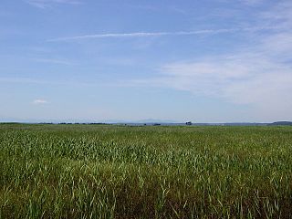
WHotokenuma (仏沼) is a wetland area located in the northern part of the city of Misawa, Aomori Prefecture, in the northern Tōhoku region of Japan. The wetland is connected to the eastern shores of Lake Ogawara at the base of the Shimokita Peninsula.
 W
WIkarigaseki was a village located in Minamitsugaru District in central Aomori Prefecture, Japan.
 W
WInagaki was a village located in Nishitsugaru District in western Aomori Prefecture, Japan.
 W
WIwaki was a town located in Nakatsugaru District in southern Aomori Prefecture, Japan.
 W
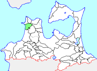
WIwasaki was a village located in Nishitsugaru District in western Aomori Prefecture, Japan.
 W
WKamikita was a town located in Kamikita District in central Aomori Prefecture, Japan.
 W
WKanita was a town located in Higashitsugaru District in northern Aomori Prefecture, Japan.
 W
WKashiwa was a village located in Nishitsugaru District in western Aomori Prefecture, Japan.
 W
WKawauchi was a town located in Shimokita District in northern Aomori Prefecture, Japan.
 W
WKizukuri was a town located in Nishitsugaru District in western Aomori Prefecture, Japan.
 W
WKodomari was a village located in Kitatsugaru District in western Aomori Prefecture, Japan.
 W
WKuraishi was a village located in Sannohe District in central Aomori Prefecture, Japan.
 W
WKurokuma Falls is a waterfall in the town of Ajigasawa, Higashitsugaru District Aomori Prefecture, Japan, on a tributary of the Akaishi River, which flows down from the World Heritage Site Shirakami Mountains. It is one of "Japan’s Top 100 Waterfalls", in a listing published by the Japanese Ministry of the Environment in 1990.
 W
WMatsumi Falls is a waterfall in the city of Towada, Aomori Prefecture, Japan, on a tributary of the Oirase River, which flows down from Lake Towada. It is one of "Japan’s Top 100 Waterfalls", in a listing published by the Japanese Ministry of the Environment in 1990.
 W
WMinmaya was a village located in Higashitsugaru District in northern Aomori Prefecture, Japan.
 W
WMomoishi was a town located in Kamikita District in central Aomori Prefecture, Japan.
 W
WMorita was a village located in Nishitsugaru District in western Aomori Prefecture, Japan.
 W
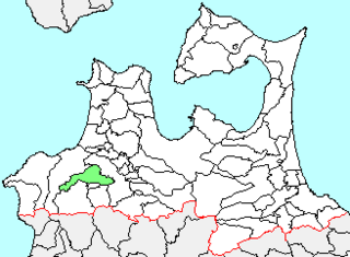
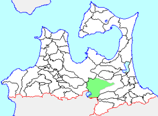
WNagawa was a town located in Sannohe District in central Aomori Prefecture, Japan. On January 1, 2006 Nagawa was merged into the neighboring town of Nanbu, and thus it no longer exists as an independent municipality.
 W
WNakasato was a town located in Kitatsugaru District in western Aomori Prefecture, Japan.
 W
WNamioka was a town located in Minamitsugaru District in central Aomori Prefecture, Japan.
 W
WNangō was a village located in Sannohe District in central Aomori Prefecture, Japan.
 W
WŌhata was a town located in Shimokita District in northern Aomori Prefecture, Japan.
 W
WThe Oirase River is a river located in eastern Aomori Prefecture, in the Tōhoku region of northern Japan. The Oirase River is the only river that drains Lake Towada, a large caldera lake that lies on the border of Aomori and Akita Prefectures. The river flows in a generally eastern direction, through the municipalities of Towada, Rokunohe, Oirase, and Hachinohe before exiting into the Pacific Ocean. The upper reaches of the river form a scenic gorge with numerous rapids and waterfalls, and is one of the major tourist attractions of the Towada-Hachimantai National Park. The lower reaches of the river are used extensively for irrigation.
 W
WOnoe was a town located in Minamitsugaru District in central Aomori Prefecture, Japan.
 W
WThe Sanriku Coast is a coastal region on the Pacific Ocean, extending from southern Aomori Prefecture, through Iwate Prefecture and northern Miyagi Prefecture in northeastern Honshū, which is Japan's main island. The name comes from the historical region of Sanriku, referring to the former provinces of Rikuō, Rikuchū and Rikuzen.
 W
WShariki was a village located in Nishitsugaru District in western Aomori Prefecture, Japan. The village was situated on the west coast of Tsugaru Peninsula, facing the Sea of Japan.
 W
WShimoda was a town located in Kamikita District in central Aomori Prefecture, Japan.
 W
WShimokita Hantō Quasi-National Park is a quasi-national park in the Shimokita Peninsula of Aomori Prefecture in the Tōhoku region of far northern Honshū in Japan. It is rated a protected landscape according to the IUCN. The park, consists of several discontinuous locations, which include:the volcanic peaks and caldera lakes of the Osorezan Mountain Range and surrounding forests. Yagen Valley, with its hot springs the coastal rock formations of Hotokegaura on the west coast of Shimokita Peninsula Cape Ōma, the northernmost point of Honshū Cape Shiriya, the northeasternmost point Honshū and the Sarugamori Sand Dunes Taijima, an island off the coast of Wakinosawa
 W
WShiura was a village located in Kitatsugaru District in western Aomori Prefecture, Japan.
 W
WSōma was a village located in Nakatsugaru District in southern Aomori Prefecture, Japan.
 W
WTairadate was a village located in Higashitsugaru District in northern Aomori Prefecture, Japan.
 W
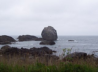
WThe Tanesashi Coast is section of the coastline on the Pacific Ocean, located in the southern portion of the city of Hachinohe, Aomori Prefecture, in the Tōhoku region of northern Japan. It is extends for 12 kilometres (7.5 mi) from the island of Kabushima south towards the city of Kuji in Iwate Prefecture. The coast was nationally designated a Place of Scenic Beauty in 1937.
 W
WTokiwa was a village located in Minamitsugaru District in central Aomori Prefecture, Japan.
 W
WTowadako was a town located in Kamikita District in central Aomori Prefecture, Japan.
 W
WTsugaru Fujimi Lake also known as Mawarizeki Ōtameike (廻堰大溜池) is a reservoir that is located almost entirely within the town of Tsuruta in Aomori Prefecture, Japan, though a portion of its southern shore lies within the city of Hirosaki. It was built in 1660 to collect snowmelt in order to irrigate the fields in the surrounding area.
 W
WThe Tsugaru Peninsula is a peninsula in Aomori Prefecture, at the northern end of Honshū island, Japan. The peninsula projects north into the Tsugaru Strait separating Honshū from Hokkaidō. The western coast is on the Sea of Japan, while on its eastern coast are Aomori Bay and Mutsu Bay. The peninsula is bisected from Cape Tappi at its northern end to the Hakkōda Mountains on its southern end by the Tsugaru Mountains. Across the Tsugaru strait to the north is Hokkaidō's Matsumae Peninsula, to which it is linked by the Seikan Tunnel.
 W
WTsugaru Quasi-National Park is a quasi-national park in Aomori Prefecture in the far northern Tōhoku region of Honshū in Japan. It is rated a protected landscape according to the IUCN. The park includes a number of discontinuous areas on Tsugaru Peninsula, including the volcanic peaks of Mount Iwaki, a portion of the primeval Siebold's beech forests of Shirakami-Sanchi UNESCO World Heritage Site, Cape Tappi, other coastal areas of northern Tsugaru Peninsula, and the wetlands of Juniko and Jusanko lakes and marshes.
 W
WWakinosawa was a village located in Shimokita District in northern Aomori Prefecture, Japan.