 W
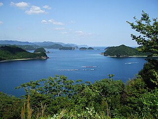
WAgo Bay is a bay in the city of Shima, Mie Prefecture, Japan. It is part of the Ise-Shima region.
 W
WAkeno Air Field is a military aerodrome of the Japan Ground Self-Defense Force. It is located 3.2 NM northwest of Ise in the Mie Prefecture, Japan.
 W
WDaian was a town located in Inabe District, Mie Prefecture, Japan.
 W
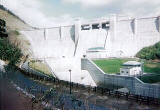
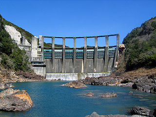
WErihara Dam (恵利原ダム) is a dam in Shima, Mie Prefecture, Japan.
 W
WFujiwara was a town located in Inabe District, Mie Prefecture, Japan.
 W
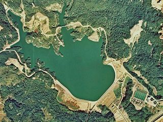
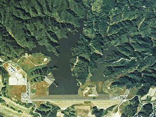
WHachisu Dam (蓮ダム) is a dam in southwestern Matsuzaka, Mie Prefecture, Japan, completed in 1991.
 W
WHamajima was a town located in the former Shima District, Mie Prefecture, Japan.
 W
WHinachi Dam is a dam in Nabari, Mie Prefecture, Japan, completed in 1998. It is located about 2 miles east of Shōrenji Dam, which is actually on a different branch of the Nabari River.
 W
WHokusei was a town located in Inabe District, Mie Prefecture, Japan.
 W
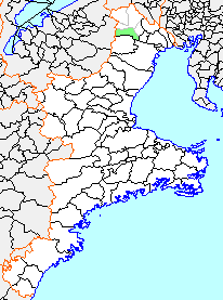
WInabe is a district located in Mie Prefecture, Japan.
 W
WInabe was a town located in Inabe District, Mie Prefecture, Japan.
 W
WIsaka Dam is a dam in Yokkaichi, Mie Prefecture, Japan, completed in 1966.
 W
WThe Ise-wan Ferry (伊勢湾フェリー), or Ise Bay Ferry is a ferry that runs between the Port of Toba in Toba, Mie Prefecture and the Port of Irago in Tahara, Aichi Prefecture, Japan. The ferry is operated by the Ise-wan Ferry Corporation.
 W
WIseshima Skyline , is a sight seeing toll road going through the Asamayama mountain, in Mie Prefecture, Japan.
 W
WKami-shima (神島) is an inhabited island located in Ise Bay off the east coast of central Honshu, Japan. It is administered as part of the city of Toba in Mie Prefecture.
 W
WKamiji Dam is a dam in Shima, Mie Prefecture, Japan.
 W
WKashiko Island is an island in Ago Bay. It is in the city of Shima, Mie Prefecture, Japan.
 W
WKihoku is a town located in Mie Prefecture, Japan. As of September 2012, the town had an estimated population of 17,885 and a population density of 69.6 persons per km2. The total area was 257.01 km2.
 W
WKii Province , or Kishū (紀州), was a province of Japan in the part of Honshū that is today Wakayama Prefecture, as well as the southern part of Mie Prefecture. Kii bordered Ise, Izumi, Kawachi, Shima, and Yamato Provinces. The Kii Peninsula takes its name from this province.
 W
WThe Kiso River is a river in Japan roughly 229 km (142 mi) long, flowing through the prefectures of Nagano, Gifu, Aichi, and Mie before emptying into Ise Bay a short distance away from the city of Nagoya. It is the main river of the Kiso Three Rivers and forms a major part of the Nōbi Plain. The valley around the upper portion of the river forms the Kiso Valley.
 W
WKogakkan University is a private university at Ise, Mie, Japan. The predecessor of the school was founded in 1882, and it was chartered as a university in 1940.
 W
WKomori Dam is a dam in Kumano, Mie Prefecture, Japan. Construction of the dam began in 1963 and was completed in 1965.
 W
WKozukumi-jima (小築海島) is an island located in Ise Bay off the east coast of central Honshu, Japan. It is administered as part of the city of Toba in Mie Prefecture.
 W
WKuchisubo Dam is a dam in Mie Prefecture, Japan, completed in 1961.
 W
WThe Kumano River is a river in the Kii Peninsula of central Japan, located in Nara, Wakayama and Mie Prefectures. It is 183 kilometres (114 mi) long and has a watershed of 2,630 square kilometres (1,020 sq mi).
 W
WKuwana is a district located in Mie Prefecture, Japan.
 W
WMatoya Bay is a bay in the city of Shima and Toba, Mie Prefecture, Japan. It is part of the Ise-Shima region.
 W
WMeoto Iwa (夫婦岩), or the Married Couple Rocks, are two rocky stacks in the sea off Futami, Mie, Japan. They are joined by a shimenawa and are considered sacred by worshippers at the neighboring Futami Okitama Shrine. According to Shinto, the rocks represent the union of the creator of kami, Izanagi and Izanami. The rocks, therefore, celebrate the union in marriage of man and woman. The rope, which weighs over a ton, must be replaced several times a year in a special ceremony. The larger rock, said to be male, has a small torii at its peak.
 W
WMie is a district located in Mie Prefecture, Japan.
 W
WMisedani Dam is a multipurpose concrete Arch-gravity dam in located in Ōdai, Mie Prefecture, Japan. completed in 1966. The dam is one of several crossing the Miyagawa River, and was intended for hydroelectric power generation, and for the supply of industrial water to the Ise Bay industrial region.
 W
WŌdaigahara-san or Ōdaigahara-yama (大台ヶ原山), also Hinode-ga-take or Hide-ga-take (日出ヶ岳) is a mountain in the Daikō Mountain Range and on the border between the prefectures of Mie and Nara, Japan. The mountain is the highest in Mie at 1695 metres. Walking trails from the Nara side start from a car park at about 1400 metres. The mountain is famous for wild deer, and also for wild birds, especially Wren and Japanese Robin, as well as Treecreepers and Woodpeckers. In 1980 an area of 36,000 hectares in the region of Mount Ōdaigahara and Mount Ōmine was designated a UNESCO Man and the Biosphere Reserve.
 W
WNagashima Spa Land is an amusement park in Kuwana, Mie, Japan. It features several roller coasters, thrill rides, and kid rides, a giant Ferris wheel, and a water park. As of 2012, Nagashima Spa Land is the 18th most visited amusement park in the world.
 W
WNakazato Dam is a dam in Mie Prefecture, Japan, completed in 1976.
 W
WThe Nanairo Dam is a concrete gravity-arch dam located in Kumano, Mie Prefecture, Japan. The dam crosses the Kitayama River, a tributary of the Kumano River near the border of Mie Prefecture with Wakayama Prefecture.
 W
WŌzukumi-jima (大築海島) is an island located in Ise Bay off the east coast of central Honshu, Japan. It is administered as part of the city of Toba in Mie Prefecture.
 W
WSakatejima (坂手島) also known as Sakate Sima, Sakate-jima, or Sakate-shima, is an island located in Ise Bay off the east coast of central Honshu, Japan. It is administered as part of the city of Toba in Mie Prefecture. It is the smallest of the four inhabited islands of Toba, and is the closest of the four islands to the mainland. Landmarks in the area include Toba-kō and Nakanogō-eki. Time zone is Asia/Tokyo.
 W
WThe Seta River is a river that has both its source and its mouth in the city of Ise, Mie Prefecture, Japan. It flows through the heart of Ise. In 1980,it was designated the most polluted river in Mie, however it no longer holds this status due to cleanup efforts by the city of Ise.
 W
WShima was a town located in the former Shima District, Mie Prefecture, Japan.
 W
WShorenji Dam is a dam in Nabari, Mie Prefecture, Japan, completed in 1970. It is located about 2 miles west of Hinachi Dam, which is actually on a different branch of the Nabari River.
 W
WSuzuka Mountains are a mountain range running through Mie Prefecture and along the borders of Gifu and Shiga prefectures in central Japan. The tallest peak in the range is Mount Oike at 1,247 m (4,091 ft). In spite of its height, Mount Oike is not the most visited mountain; that distinction belongs to Mount Gozaisho because of its Gozaisho Ropeway, making reaching the peak much easier.
 W
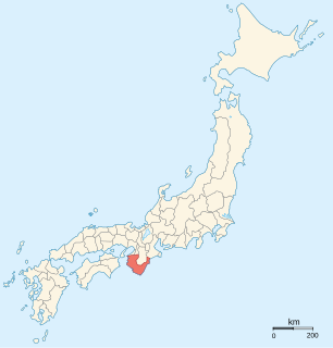
WTaki District is a rural district located in Mie Prefecture, Japan.
 W
WTōshijima (答志島) is an inhabited island located in Ise Bay off the east coast of central Honshu, Japan. It is administered as part of the city of Toba in Mie Prefecture. It is the largest of the outlying islands of Toba.
 W
WTsu City College is a public junior college in Tsu, Mie, Japan. It was founded in 1952.
 W
WUdono was a village located in Minamimuro District, Mie Prefecture, Japan.
 W
WUeno was a city located in Mie Prefecture, Japan. The city was founded on September 10, 1941. It was often referred to as Iga-Ueno to avoid confusion with other Uenos, including one in Ise Province which is now part of Yokkaichi.
 W
WThe Yōrō Mountains are a mountain range straddling the border between Gifu and Mie prefectures in Japan. They form part of the western border of the Nōbi Plain.
 W
WYunoyama Onsen (湯の山温泉), or Yunoyama Hot Springs, is a hot springs resort located near Mount Gozaisho in the town of Komono, Mie Prefecture, Japan. The area is within the borders of the Suzuka Quasi-National Park.