 W
WAbbeville is a townland in the Barony of Ormond Lower, County Tipperary, Ireland. It is located in the Civil parish of Lorrha.
 W
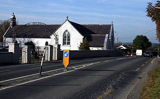
WAglish is a small settlement in County Tipperary in Ireland. It is in the Civil parish of Aglishcloghane in the historical barony of Ormond Lower. It is located approximately 7 km north of Borrisokane, 1 km east of the R438 road.
 W
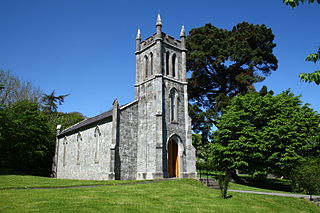
WArdcroney, officially Ardcrony, is a village and townland on the N52 National secondary road 10 km (6.2 mi) north of Nenagh in County Tipperary, Ireland. It is also forms a civil parish in the historical barony of Ormond Lower. It is halfway between Nenagh and Borrisokane.
WAshleypark is a townland in the historical Barony of Ormond Upper, County Tipperary, Ireland.
WBallyartella is a townland in the historical Barony of Ormond Lower, County Tipperary, Ireland. It is located between the Nenagh River and the R495 road which runs from Nenagh to Dromineer.
WClerihan is a village in County Tipperary, Ireland. It is also a civil parish in the barony of Iffa and Offa East. It is approximately 8.5 kilometres north of Clonmel. Its name comes from the Irish meaning O'Clerahan's town. Locally, the "Bally" prefix is usually dropped and the village is almost always referred to simply as "Clerahan" which is most often spelled "Clerihan".
 W
WBallycommon is a village and townland in County Tipperary, Ireland, near Nenagh. It is located in the barony of Ormond Lower and is part of the parish of Puckane in the Roman Catholic Diocese of Killaloe. Kildangan GAA is the local Gaelic Athletic Association club. It is not to be confused with the district and GAA team in County Offaly called Ballycommon, 5 miles east of Tullamore.
 W
WBallymacegan is a townland in the historical Barony of Ormond Lower, County Tipperary, Ireland. It is located in the civil parish of Lorrha in the north of the county and includes an area of callows alongside the River Shannon.
 W
WBallysloe is a townland on the R689 regional road in County Tipperary. It is located 10 km (6.2 mi) south of Urlingford, County Kilkenny.
WBallytarsna is a townland in County Tipperary in Ireland. Occupying 1190 acres, it is located in the civil parish of Ballysheehan in the barony of Middlethird in the poor law union of Cashel.
 W
WBouladuff, also known as Inch and The Ragg, is a village near Thurles in County Tipperary, Ireland. According to the 2016 CSO census, the population of the Inch electoral division was 395. Bouladuff is in the barony of Eliogarty.
 W
WCarney is a small village in North County Tipperary in Ireland. It is located in the civil parish of Cloghprior alongside the townlands of Carneybeg, Carneycastle, Carneycastle, Carneywoodlands, and Carney Commons. It is approximately 5 km from Puckane and 8 km from Borrisokane town.
 W
WCarrig is a settlement and electoral district in the historical Barony of Ormond Lower, County Tipperary, Ireland. It is located on the N52 road between Birr and Borrisokane. The early medieval Christian psalter known as the Faddan More Psalter was discovered near here in July 2006 in a peat bog.
 W
WCarrigahorig ; is a hamlet in County Tipperary, Ireland, located 7 km (4.3 mi) east of Portumna on the N65 national secondary road.
 W
WCastleiney, officially Castleleiny and historically "Castlelyny", is a village in County Tipperary, Ireland. It is one half of the Roman Catholic parish of Loughmore-Castleiney. It is in the barony of Eliogarty.
 W
WThe Clare Glens are a wooded area with a path up the red sandstone gorge separated by the banks of the Clare river, which separates Counties Tipperary and Limerick, Ireland. It is located approximately 4km from Newport, County Tipperary, approximately 5km from Murroe on the R506 road.
WClonmore is a village in County Tipperary, Ireland. It lies on the R433 road 6 km from Templemore and 7 km from Errill in County Laois. It is part of the parish of Templemore, Clonmore and Killea. The village church, Saint Ann's Roman Catholic was built in 1832.
WCoolnamunna is a townland in the historical Barony of Ormond Upper, County Tipperary, Ireland.
 W
WCurreeny is a townsland in North County Tipperary, Ireland. It is situated 16km from Nenagh, in the Roman Catholic parish of Templederry. Curreeny is on the R497 regional road, which is the main road from Nenagh to Tipperary Town. Curreeny is in close proximity to Dolla, Templederry and Kilcommon villages and within reasonable driving distance from Limerick city, Nenagh, Thurles, Templemore, Tipperary, Newport and Cashel.
WDerry Demesne is a townland in the historical Barony of Owney and Arra, County Tipperary, Ireland.
 W
WDolla is a village in County Tipperary in Ireland, on the crossroads of the R497 and R499 regional roads. It is located at the foot of the northern flank of the Silvermine Mountains, 8 km (5.0 mi) south on Nenagh.
 W
WDrom is a village in County Tipperary, Ireland. It is located just off the main Borrisoleigh to Templemore road. Its population was 129 at the 2006 census.
 W
WDualla is a village near Cashel in Ireland in County Tipperary on the R691. A number of small housing estates have been built in the area in recent years adding to the few scattered houses along the road and parish church that constituted the village. Dualla National School began educating pupils in May 1861 and officially opened a new school in June 2012.
 W
WThe Glen of Aherlow is a valley located between Slievenamuck and the Galtee Mountains in the western part of County Tipperary in Ireland. The principal village is Lisvarrinane. There is also a hamlet at Rossadrehid, where Aherlow creamery was located before its closure in the late 20th century. Other adjacent centres of population are the villages of Galbally, Kilross and Bansha. Across the northern flank of Slievenamuck lies Tipperary Town.
WGrange is a village near Clonmel in County Tipperary, Ireland.
WGrangemockler is a village, civil parish and townland in southeastern County Tipperary, Ireland. It is located 2km southwest of Ninemilehouse. Grangemockler is the home of the Grangemockler/Ballyneale GAA.
WKilleen is a townland in the civil parish of Borrisokane, in the Barony of Ormond Lower, County Tipperary, Ireland.
 W
WLattin is a village in, south County Tipperary in Ireland. It has been inhabited for over 5000 years. The remains of some of its early residents are still in existence, in a mound just west of the village, which can be clearly seen from the Emly/Tipperary road. It is a civil parish in the barony of Clanwilliam. It is also one half of the 'Lattin and Cullen' parish in the Roman Catholic Archdiocese of Cashel and Emly.
 W
WLisheen Mine is a former lead-zinc-silver mine located between the villages of Moyne and Templetuohy in County Tipperary, Ireland. In the Rathdowney Trend, Lisheen was an underground mine where the Lisheen deposit lies at an average depth of 170 metres below surface. The mine closed in 2015.
 W
WLismakeeve is a townland in the civil parish of Glenkeen in County Tipperary, Ireland.
 W
WLisronagh is a village in County Tipperary, in Ireland.
 W
WLittleton is a village in County Tipperary, Ireland. It is within the townlands of Ballybeg and Ballydavid, about 18 km (11 mi) northeast of Cashel and to the southeast of Thurles. By-passed by the M8 in December 2008, Littleton lies at a crossroads on the R639 road. Its population was 463 at the 2006 census. It is in the barony of Eliogarty.
WMellisson is a townland in the civil parish of Buolick in the barony of Slievardagh in County Tipperary.
 W
WMilestone is a small village in the townland of Graniara in County Tipperary, Ireland. It lies on the R503 Thurles to Limerick Regional Road where it is joined by the R497 Nenagh - Tipperary Town road.
 W
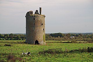
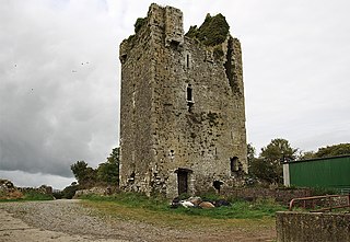
WMoycarkey Castle, in Moycarky townland, County Tipperary, is a tower-house located inside a large rectangular bawn with round flanking towers at the north-eastern and south-western corners. The entrance to the tower-house is protected by a double murder-hole.
WNew Birmingham is a small village in County Tipperary, Ireland. It is located approximately 15 kilometres from Thurles and also on the R689 regional road between Urlingford and Fethard. It is within the townland of Glengoole, and is in the barony of Slievardagh.
WNewcastle is a village in County Tipperary, Ireland. Located close to the border with County Waterford, it is in the barony of Iffa and Offa West. The River Suir runs past the village. Newcastle is located 17 kilometres from Clonmel, the county town of County Tipperary.
WNewtown is a hamlet in County Tipperary, Ireland. It is located on the R494 regional road 7 km (4.3 mi) west of Nenagh. It is in the barony of Owney and Arra. It is also part of the parish of Youghalarra in the Roman Catholic Diocese of Killaloe.
WNinemilehouse, historically called Killcullen is a village in County Tipperary, Ireland. It lies on the N76 national secondary road at its junction with the R690 regional road.
WPriorstown is a townland of County Tipperary in Ireland, four miles to the east of Clonmel on the N76 road.
 W
WPuckane, officially Puckaun, is a village in County Tipperary, Ireland. It is also a parish in the Roman Catholic Diocese of Killaloe. The village is located 10 km north of Nenagh along the R493 and close to Lough Derg and Dromineer. It had a population of about 257 as of the 2006 census.
 W
WThe R664 road is a regional road in County Tipperary, Ireland.
 W
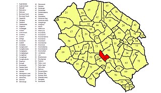
WRahelty, sometimes written Rahealty, is a civil parish in County Tipperary, Ireland. It is one of 21 civil parishes in the historical barony of Eliogarty. It contains eighteen townlands:
WRathcabbin often Rathcabban is a small village and an electoral district situated at the very north of County Tipperary in Ireland. The village is located off the R489 regional road between Portumna, County Galway and Birr, County Offaly. It is 5 km east of the River Shannon and Lough Derg.
 W
WThe Slieveardagh Hills are a low range of hills on the County Tipperary - Kilkenny border, mainly in the barony of Slievardagh. The highest point is Clomantagh Hill at 349 m and the highest point by relative height in the hills is Knocknamuck at 340m with prominence of 268m. The hills contain the source of the River Goul, which flows north and the Kings River which flows southwards from the hills.
 W
WSugarloaf Hill is a mountain peak located in the Knockmealdown Mountains on the border between County Tipperary and County Waterford.
WTempletuohy, often written Templetouhy, is a village in County Tipperary, Ireland. It is situated in the townland of Longorchard in the civil parish of Templetouhy. The local GAA club is Moyne-Templetuohy GAA which is organised by Tipperary GAA. The village is joined to Moyne to form the ecclesiastical parish of Templetuohy and Moyne in the Roman Catholic Archdiocese of Cashel and Emly. It is located on the R502 road, 9 km from Templemore to the west and 12 km from the M8 motorway to the east. According to the 2016 census, the village had a population of 282.
 W
WTyone is a townland in the historical Barony of Ormond Upper, County Tipperary, Ireland.