 W
WThe Abyss Box is a vessel containing 16 litres of water at the very high pressure of 18 megapascals to simulate the natural underwater environment of bathyal fauna living at about 1,800 metres (5,900 ft) below the surface. It is on display at Oceanopolis aquarium in Brest, France. It was designed by French researcher Bruce Shillito from Pierre and Marie Curie University in Paris.
 W
WThe Arabian Basin is an oceanic basin located in the southern part of the Arabian Sea between the Arabian Peninsula and India. It is centered at 10° N, 65° E. The basin depth ranges from 3,400 m in the north to 4,400 m in the south, with a maximum depth of 4,652 m. The floor is covered by sediments from the Indus submarine fan and is relatively smooth.
 W
WArgo is an unmanned deep-towed undersea video camera sled developed by Dr. Robert Ballard through Woods Hole Oceanographic Institute's Deep Submergence Laboratory. Argo is most famous for its role in the discovery of the wreck of the RMS Titanic in 1985. Argo would also play the key role in Ballard's discovery of the wreck of the battleship Bismarck in 1989.
 W
WThe Baffin Basin is an oceanic basin located in the middle of Baffin Bay between Baffin Island and Greenland. With a maximum depth of over 2,700 m (8,900 ft), the basin represents the deepest point of Baffin Bay. The basin formed as a result of seafloor spreading at the time of the opening of Baffin Bay around 56 million years ago.
 W
WA bottom crawler is an underwater exploration and recovery vehicle. It is designed to sink to the bottom of a body of water, where it moves about using traction against the bottom with wheels or tracks. It is usually tethered to a surface ship by cables providing power, control, video, and lifting capabilities, but this is not essential.
 W
WBunkering is the supplying of fuel for use by ships, and includes the shipboard logistics of loading fuel and distributing it among available bunker tanks. A person dealing in trade of bunker fuel is called a Bunker Trader.
 W
WJuan Carlos Castilla Zenobi is a marine biologist. He received his PhD from the University of Wales. Since 1965, he has been a faculty member at the Pontificia Universidad Católica de Chile. In 1985, he published a paper on a study which focused on a part of the Chilean coastline from which humans had been excluded. He is a recipient of the 1996 TWAS Prize.
 W
WCongelation ice is ice that forms on the bottom of an established ice cover.
 W
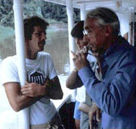
WAnita Conti was a French explorer and photographer, and the first French female oceanographer.
 W
WThe continental rise is a sediment underwater feature found between the continental slope and the abyssal plain. This feature can be found all around the world, and it represents the final stage in the boundary between continents and the deepest part of the ocean. The environment in the continental rise is quite unique, and many oceanographers study it extensively in the hopes of learning more about the ocean and geologic history.
 W
WThe Cooperative Institute for Arctic Research is designed to be a focal point for interactions between the National Oceanic and Atmospheric Administration (NOAA)/Office of Oceanic and Atmospheric Research (OAR) and the Arctic research community through the University of Alaska for research related to the Western Arctic/Bering Sea region.
 W
WDeepWorker 2000 is a submarine vehicle developed by Nuytco Research, Ltd. It is capable of descending to a depth of 610 m (2001 ft) and remaining submerged for 12 hours. In 1999, it was deployed to the continental shelf and upper continental slope on a five-year mission in association with the National Geographic Society's Sustainable Seas Expeditions.
 W
WDigges Sound is a Canadian Arctic waterway in Qikiqtaaluk, Nunavut, Canada. The sound is located at the juncture where the Hudson Strait meets northeastern Hudson Bay close to the northern tip of the Ungava Peninsula, between Digges Islands and Cape Wolstenholme. Ivujivik, Quebec, the northernmost settlement in any Canadian province, is located on the south coast of the sound.
 W
WIn fluid dynamics, an edge wave is a surface gravity wave fixed by refraction against a rigid boundary, often a shoaling beach. Progressive edge waves travel along this boundary, varying sinusoidally along it and diminishing exponentially in the offshore direction.
 W
WThe Ekman water bottle is a sea water temperature sample device. The cylinder is dropped at the desired depth, the trap door below is opened to let the water enter and then closed tightly. This can be repeated at different depths as each sample goes to a different chamber of the insulated bottle.
 W
WRV Endeavor is a research vessel owned by the National Science Foundation and operated by the University of Rhode Island (URI) under a Charter Party Agreement as part of the University-National Oceanographic Laboratory System (UNOLS) fleet. The vessel is homeported at the Narragansett, Rhode Island at the URI Bay Campus.
 W
WThe Finite Volume Community Ocean Model is a prognostic, unstructured-grid, free-surface, 3-D primitive equation coastal ocean circulation model. The model is developed primarily by researchers at the University of Massachusetts Dartmouth and Woods Hole Oceanographic Institution, and used by researchers worldwide. Originally developed for the estuarine flooding/drying process, FVCOM has been upgraded to the spherical coordinate system for basin and global applications.
 W
WThe Gakkel Ridge is a mid-oceanic ridge, a divergent tectonic plate boundary between the North American Plate and the Eurasian Plate. It is located in the Eurasian Basin of the Arctic Ocean, between Greenland and Siberia, and has a length of about 1,800 kilometers. Geologically, it connects the northern end of the Mid-Atlantic Ridge with the Laptev Sea Rift.
 W
WGeologists Seamounts are seamounts in the Pacific Ocean, 100 miles (160 km) south of Honolulu, Hawaii and 100–200 kilometres (62–124 mi) southwest from Big Island. Clockwise from north they are named Perret, Jaggar, McCall, Pensacola, Daly, Swordfish, Cross, Washington and Ellis. The seamounts developed during the Cretaceous, about 80 million years ago, and there is no geological relationship to the neighbouring Hawaiian Islands although there may be one to the Musicians Seamounts.
 W
WGreen Canyon is an area in the Gulf of Mexico that is rich in oil fields and under the control of the Bureau of Ocean Energy Management. Among other oil fields Green Canyon consist of Atlantis operated by BP, Marco Polo and K2 operated by Anadarko Petroleum, Manatee operated by Shell, Shenzi operated by BHP Billiton, Droshky operated by Marathon Oil, and Tahiti operated by Chevron Corporation.
 W
WGSHHG is a high-resolution shoreline data set amalgamated from two data bases in the public domain. The data have undergone extensive processing and are free of internal inconsistencies such as erratic points and crossing segments. The shorelines are constructed entirely from hierarchically arranged closed polygons. The four-level hierarchy is as follows: seashore, lakes, islands within lakes, ponds within islands within lakes.
The Halmos College of Natural Sciences and Oceanography is a natural science college at Nova Southeastern University in Florida. The college offers programs in subjects like biology and mathematics and conducts oceanographical research.
 W
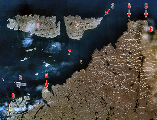
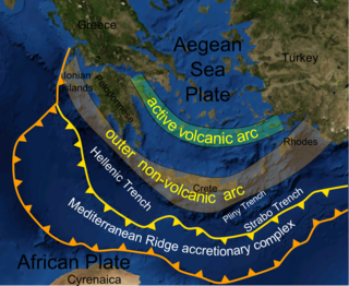
WThe Hellenic Trench is a hemispherical-scale long narrow depression in the Ionian Sea.
 W
WAn ice shove, ice surge, ice heave, ivu, or shoreline ice pileup is a surge of ice from an ocean or large lake onto the shore. Ice shoves are caused by ocean currents, strong winds, or temperature differences pushing ice onto the shore, creating piles up to 12 metres high. Some have described them as 'ice tsunamis', but the phenomenon works like an iceberg. Witnesses have described the shove's sound as being like that of a train or thunder. Ice shoves can damage buildings and plants that are near to the body of water. Arctic communities can be affected by ice shoves.
 W
WThe Iceland Plateau or Icelandic Plateau is an oceanic plateau in the North Atlantic Ocean consisting of Iceland and its contiguous shelf and marginal slopes. It resides on an active rift zone of the Mid-Atlantic Ridge from which extensive tholeiitic plateau basalts and a number of large rhyolitic domes have been extruded.
 W
WRV Investigator is an Australian marine research vessel which was designed by RALion. It was constructed in Singapore and is owned and managed by the Commonwealth Scientific and Industrial Research Organisation (CSIRO), through Australia's Marine National Facility, with its operations funded by the Australian Government to undertake oceanographic, geoscience, ecosystem and fisheries research. In May 2009 the Australian Government allocated A$120 million for a new ocean-going research vessel to replace the 1972 built RV Southern Surveyor, which has served as the principal research ship for Australia's Marine National Facility since 1988. RV Investigator was transferred from Sembawang Shipyard to the delivery crew on 5 August 2014 for pre-departure testing and setup. The vessel arrived at its home port of Hobart on 9 September 2014 and was officially launched on 12 December 2014.
 W
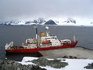
WRRS James Clark Ross is a supply and research ship operated by the British Antarctic Survey.
WKeathley Canyon is an undersea canyon in the United States Exclusive Economic Zone in the Gulf of Mexico. The canyon is named for the hydrographic survey ship USNS Sergeant George D. Keathley (T-AGS-35).
 W
WThe Leibniz Institute for Baltic Sea Research is a research institution located in Warnemünde (Rostock), Germany.
 W
WThe limnetic zone is the open and well-lit area of a freestanding body of freshwater, such as a lake or pond. Not included in this area is the littoral zone, which is the shallow, near-shore area of the water body. Together, these two zones comprise the photic zone.
 W
WR/V Marcus Langseth is a research vessel owned by the National Science Foundation and operated by the Lamont-Doherty Earth Observatory (LDEO) of Columbia University as a part of the University-National Oceanographic Laboratory System (UNOLS) fleet. The Marcus G. Langseth was dedicated on December 4 2007, came into service in early 2008, replacing the R/V Maurice Ewing. Langseth is intended primarily to collect multichannel seismic data, including 3-D surveys. The ship was purchased from the geophysical survey company WesternGeco in 2004, having previously been named M/V Western Legend.
 W
WAlfred Merz was an Austrian geographer, oceanographer and director of the Institute of Marine Science in Berlin. He died of pneumonia in Buenos Aires while on an expedition to survey the South Atlantic and is buried in Perchtoldsdorf. Merz Peninsula is named after him.
 W
WRV Neil Armstrong (AGOR-27) is the designation for a new oceanographic research ship, first of the Neil Armstrong-class research vessels, to be owned by the United States Navy and operated by Woods Hole Oceanographic Institution. Secretary of the Navy Ray Mabus announced on September 24, 2012 that the research vessel was to be named after Neil Armstrong, the first person to walk on the Moon and a former naval aviator who served in the Korean War.
 W
WThe Ocean Drilling Program (ODP) was a multinational effort to explore and study the composition and structure of the Earth's oceanic basins. ODP, which began in 1985, was the successor to the Deep Sea Drilling Project initiated in 1968 by the United States. ODP was an international effort with contributions of Australia, Germany, France, Japan, the United Kingdom and the ESF Consortium for Ocean Drilling (ECOD) including 12 further countries. The program used the drillship JOIDES Resolution on 110 expeditions (legs) to collect about 2000 deep sea cores from major geological features located in the ocean basins of the world. Drilling discoveries led to further questions and hypotheses, as well as to new disciplines in earth sciences such as the field of paleoceanography. In 2004 ODP transformed into the Integrated Ocean Drilling Program (IODP).
 W
WThe Ocean World of Jacques Cousteau by Jacques Cousteau is an encyclopedia in 21 volumes, that forms an encyclopedia of marine life.
 W
WPancake ice is a form of sea ice that consists of round pieces of ice with diameters ranging from 30 centimetres (12 in) to 3 metres (9.8 ft), depending on the local conditions that affect ice formation. It may have a thickness of up to 10 centimetres (3.9 in). Pancake ice features elevated rims formed by piling the frazil ice/slush/etc. up the edges of pancakes when they collide, both due to random bumping into each other and because of periodic compressions at wave troughs. These rims are the first indication of the onset of the formation of the pancake ice from less consolidated forms of ice.
 W
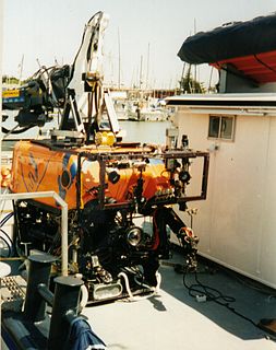
WRV Point Lobos was a research vessel operated by the Monterey Bay Aquarium Research Institute (MBARI). It was the platform of operations for the ROV Ventana.
 W
WRV Sally Ride (AGOR-28) is a Neil Armstrong-class research vessel owned by the United States Navy and operated by the Scripps Institution of Oceanography.
 W
WSCICEX, standing for Scientific Ice Expeditions, was a five-year (1995–1999) scientific research program involving a collaboration between the U.S. Navy and academic researchers from a variety of different universities. The object of study was geophysical and oceanological conditions in the Arctic Ocean. The Navy made available a nuclear submarine for each research cruise.
SeaDataNet is an international project of oceanography. Its main goal is to enable the scientific community to access historical datasets owned by national data centers.
 W
WA shore lead is an oceanographic term for a waterway opening between pack ice and shore. While the gap of water may be as narrow as a tide crack if closed by wind or currents, it can be as wide as 1,000 feet (300 m). Its formation can be influenced by tidal action, or subsurface conditions, such as current and ocean floor. Commonly, a shore lead is navigable by surface vessels.
 W
WThe RV Southern Surveyor was an Australian marine research vessel. It was owned and managed by the Commonwealth Scientific and Industrial Research Organisation (CSIRO), with its operations funded by the Australian Government to undertake oceanographic, geoscience, ecosystem and fisheries research. It was built in the UK in 1972 and acquired by CSIRO in 1988. It was replaced in 2014 by the RV Investigator.
 W
WRV Sprightly was a 42m research vessel owned by the Australian Commonwealth Scientific Research Organisation (CSIRO). Sprightly originally served as a salvage tug in the North Atlantic in World War II. Following the war it was purchased by the CSIRO where it spent 40 years on scientific duties before being retired and replaced by the RV Franklin.
 W
WStation P is an ocean measurement site, located at 50 degrees north latitude, 145 degrees west longitude.
 W
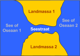
WA tidal strait is technically not a river but a strait connecting two oceans or seas. Tidal straits are narrow seaways through which tidal currents flow. Tidal currents are usually unidirectional but sometimes are bidirectional. They are frequently of tectonic origin. In them, currents develop because of elevation differences between the water basins at both ends.
 W
WUpper Shoreface refers to the portion of the seafloor that is shallow enough to be agitated by everyday wave action, the wave base.
 W
WAn urchin barren is an area of the shallow part of the ocean where the population growth of sea urchins has gone unchecked, causing destructive grazing of kelp forests.
 W
WAn oceanographic water mass is an identifiable body of water with a common formation history which has physical properties distinct from surrounding water. Properties include temperature, salinity, chemical - isotopic ratios, and other physical quantities.