 W
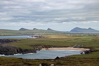
WAn Triúr Deirféar, are a group of three peaks at the northwestern end of the Dingle Peninsula in County Kerry, Ireland.
 W
WAsdee is a small village in County Kerry, Ireland.
 W
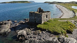
WBallinskelligs Castle is a castle located near Ballinskelligs on the Iveragh Peninsula in Kerry, Ireland. The castle is situated on the western shore of Ballinskelligs Bay, on a narrow promontory which is subject to heavy erosion. The castle was constructed by the MacCarthy Mórs in the 16th century to protect the bay from pirates, and possibly in order to charge a tariff on incoming trade vessels.
WBallymacelligott is a civil parish in the north of County Kerry in Ireland. It is situated 7 kilometres (4.3 mi) east of Tralee.
 W
WBeenoskee or Benoskee is a 826 m (2,710 ft) mountain on the Dingle Peninsula in Kerry, Ireland.
 W
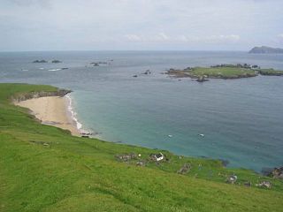
WBeginish is one of the Blasket Islands of County Kerry, Ireland.
WCamp is a village near the Slieve Mish Mountains in County Kerry, Ireland, on the Dingle Peninsula. It is close to the Dingle Way and is a destination for holiday makers.
 W
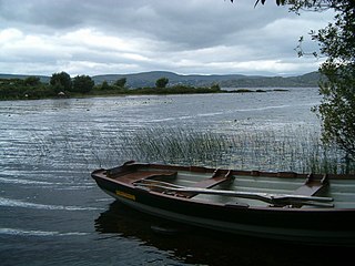
WCaragh Lake, also Lough Caragh, is a lake in the Reeks District in County Kerry, Ireland. The lake was formed by the damming of the Caragh River.
WCauseway is a village in County Kerry in Ireland. In the village there's not two shops,there is only one shop/post office, there are two hairdressers, a fast food outlet, a funeral home, a bakery and four pubs. There's no community centre, there is a GAA pitch, and a health centre, a church, a primary school, and a secondary school.
 W
WAn Clochán is a village and townland on the Dingle Peninsula of County Kerry, Ireland, at the foot of Mount Brandon. In 1974 the village was added to the Corca Dhuibhne Gaeltacht. It has a population of 297.
WCoolgarriv is a townland on the outskirts of Killarney, County Kerry, Ireland. It is located on Madam's Hill, overlooking Killarney in the nearby valley. It is bordered by Aghadoe and Knockasarnett townlands. Coolgarriv is part of Fossa parish, in the Diocese of Kerry.
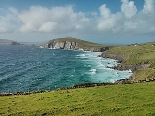
WCoumeenoole is a village in County Kerry, Ireland. It is located on Slea Head, on the Dingle Peninsula, to the west of Dingle. Due to its location on the coast, the town and beaches are a popular tourist destination.
 W
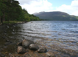
WLough Currane, also called Lough Leeagh, is a lake in County Kerry, Ireland. Waterville lies on its western bank, close to the Atlantic Ocean and Raheen lies on its southern bank. It covers an area of 2,500 acres (10 km2) and is 3.5 miles (5.6 km) long and 2 miles (3.2 km) at the widest point. The lake had the St. Finan Cam monastery on Church Island. To the south of the lake is Inis Uasal, an island dedicated to St. Finan. The Annals of Inishfallen mention that Amchad, the "anchorite of God" was buried on the island in 1058.
WCurrans is a small village in County Kerry, Ireland. It is 8.5 km southwest of Castleisland.
WDerrymore is a rural district of County Kerry in south-west Ireland. It lies between the Slieve Mish mountains and the Atlantic Ocean, some 11 km (7 mi) west of Tralee on the Dingle peninsula. A sandy beach, known as Derrymore Strand, is quite popular with locals and tourists during the summer months. Derrymore Island, situated to the east of Derrymore Strand, is a nature reserve supporting many rare plant communities and is an important high-tide roosting area for shore birds.
WDooneen is a townland approximately two miles north of Castleisland, County Kerry on the N21 road to Limerick. Dooneen Wood and Castleisland golf course are situated in the area. Journalist Con Houlihan was born in Dooneen.
 W
WDunmore Head is a promontory in the westernmost part of the Dingle Peninsula, located in the barony of Corca Dhuibhne in southwest County Kerry, Ireland. The headland, together with parts of Mount Eagle's northern slopes is formed from steeply dipping beds of the cross-bedded sandstones of the Eask Sandstone Formation, dating from the Devonian period and traditionally referred to as the Old Red Sandstone.
 W
WDunquin, meaning "Caon's stronghold", is a Gaeltacht village in west County Kerry, Ireland. Dunquin lies at the most westerly tip of the Dingle Peninsula, overlooking the Blasket Islands. At 10°27'16"W, it is the most westerly settlement of Ireland. Nearby Dunmore Head is the most westerly point of mainland Ireland. The town is linked to Dingle via the R559 regional road.
 W
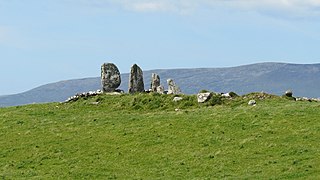
WEightercua Irish: Íoċtar Ċua , meaning " "the place or holy place or harbor" that is Íoċ or "below" - the word is a specifically geographical term that does not adequately translate into English which does not designate a "place down below" with categorically geographical differentiation") is a four-stone alignment (stone-row) Megalithic tomb, located 1.5 km south-south-east of Waterville, County Kerry, Ireland. The tallest stone reaches 9 feet in height, and the alignment streaches for twenty five feet in an east-west direction. Surrounding artifacts, including remains of a possible tomb and an ancient enclosure, suggest that the site had a ritual purpose at one time. Eightercua is thought to originate from circa. 1700 BC, and by tradition is the burial place of Scéine, wife of the leader of the Milesian invaders, Amergin mac Míled.
 W
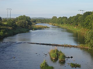
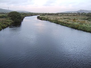
WThe River Feale rises near Rockchapel in the Mullaghareirk Mountains of County Cork in the southwest of Ireland and flows northwestwards for 75 kilometres through Abbeyfeale in County Limerick and Listowel in County Kerry before finally emptying into Cashen Bay, a wide estuary north of Ballyduff. Then it flows out through the Shannon's estuary and joins with the Atlantic Ocean with a flow rate of 34.6 m2/s. The river, along with its tributaries, combine to add to over 160 km of waterways. For the final 10km stretch it is known as the Cashen River. The river contains a large salmon and sea trout population.
 W
WFenit Island is a populated island, on the coast of County Kerry, connected to the mainland by a sandbar. Located in Tralee Bay, the island encloses Barrow Harbour. Historically, the area was called 'Fenit Within'. It is adjacent to the areas of 'Tawlacht' and 'Fenit Without' on the mainland. The terms within/without refer to the walled protection that surrounded parts of the island from attackers from the landward side.
 W
WFiries is a village in County Kerry, Ireland. It is on the R561 road between Farranfore and Castlemaine. The population in 2011 was 491.
 W
WGallarus Castle is a four-storey rectangular tower house in Baile na nGall, County Kerry, Ireland and is notable as one of the few fortified structures preserved on the Dingle Peninsula.
 W
WGlanmore Lake is a freshwater lake in the southwest of Ireland. It is located on the Beara Peninsula in County Kerry.
 W
WInishvickillane or Inishvickillaun is one of the Blasket Islands of County Kerry, Ireland.
 W
WInnisfallen or Inishfallen is an island in Lough Leane; one of the three Lakes of Killarney in County Kerry, Ireland.
 W
WThe River Inny is a river in County Kerry, Ireland.
 W
WKerry Head is a headland located in County Kerry, Ireland that stretches into the Atlantic Ocean just north of Banna Strand. On the southern edge of the headland sits Ballyheigue.
 W
WKilderry is a rural area in County Kerry, Ireland. It lies close to the N70 National secondary road between Milltown (2.6 km) and Killorglin (4.8 km). The townlands of Kilderry North and Kilderry South are in the civil parish of Kilcolman.
 W
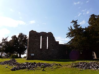
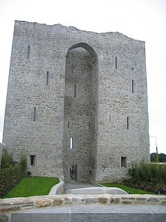
WThe last bastion against Queen Elizabeth I in the First Desmond Rebellion, Listowel Castle was built in the 15th century and was the last fortress of the Geraldines to be subdued. It fell after 28 days siege to Sir Charles Wilmot on 5 November 1600, who had the castle's garrison executed in the following days. One of the best examples of Anglo-Norman architecture in County Kerry, the castle has now been restored to some of its former glory. The castle is open to the public for tours on a daily basis.
 W
WLittle Skellig is an island in the Atlantic Ocean, 11 km south-west of Valentia Island in County Kerry, Ireland.
 W
WThe Magharee Islands, also known as "The Seven Hogs", are a group of uninhabited islands located off Rough Point at the northern tip of the Magharee Peninsula in County Kerry, Ireland. The islands, which are part of the parish of Castlegregory, are well known as excellent diving and snorkelling destinations.
WMaglass is a townland in the parish of Ballymacelligott, which is situated between two towns, Tralee and Castleisland, County Kerry, Ireland. Ballymacelligott is the biggest parish in Munster. Maglass is a farming area, with the nearest shop and post office is approximately 1 mile from Maglass in Ballydwyer. The nearest church is a further mile in Clogher, where there is also a National School.
WMaharees or Magharees is a 5 km long tombolo located on the northern side of the Dingle Peninsula in County Kerry, Ireland.
 W
WMuckross Lake, also called Middle Lake or The Torc, is a lake in Killarney National Park, County Kerry, Ireland. It is one of the three famous Lakes of Killarney, along with Lough Leane and Upper Lake. It is Ireland's deepest lake, reaching to 75 metres (246 ft) in parts.
 W
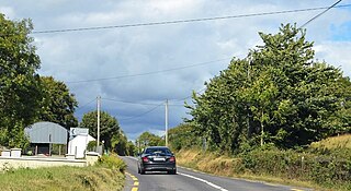
WThe R561 road is a regional road in Ireland. It is on the Dingle Peninsula in County Kerry. Part of the road is on the Wild Atlantic Way.
 W
WThe R565 road is a regional road in Ireland. It is a road on the Iveragh Peninsula and Valentia Island in County Kerry. The road is part of the Wild Atlantic Way.
 W
WThe R566 road is a regional road in Ireland. It is a road on the Iveragh Peninsula in County Kerry. Part of the road is on the Wild Atlantic Way.
WThe R567 road is a regional road in Ireland. It is a road on the Iveragh Peninsula in County Kerry. The road is part of the Wild Atlantic Way. Parts of the road form part of the Emlagh Loop walking trail.
 W
WThe R573 road is a regional road in Ireland. It is a coastal loop road from the R571 on the Beara Peninsula in County Kerry. Part of the road is on the Wild Atlantic Way.
WReenard is a townland in County Kerry, Ireland. It is located in the deep south on the Iveragh peninsula on the southwest coast of Ireland opposite Valentia Island about 10 miles west of Cahersiveen. Reenard is connected to the Irish road network by a road crossing the N70 national secondary route at Point's Cross.
 W
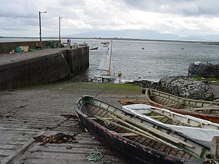
WRossmore Island is a former island in County Kerry, now joined to the mainland via a bridge.
 W
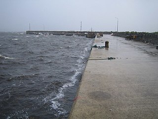
WScraggane is a fishing port located on the Maharees peninsula near Castlegregory in County Kerry, Ireland.
 W
WSlea Head is a promontory in the westernmost part of the Dingle Peninsula, located in the barony of Corca Dhuibhne in southwest County Kerry, Ireland. It belongs to the province of Munster and the county of Kerry and is served by the R559 road; the nearest villages are Ballyickeen and Coumeenoole. The headland itself, together with the larger part of Mount Eagle's southern slopes is formed from steeply dipping beds of the pebbly sandstones and conglomerates of the Slea Head Formation, dating from the Devonian period and traditionally referred to as the Old Red Sandstone.
WSpa is a village located in County Kerry, Ireland.
 W
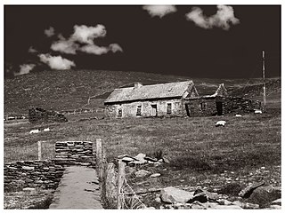
WTemplenoe is a civil parish in County Kerry, Ireland. It is situated four miles from Kenmare, on the N70 road to Sneem, which forms part of the Ring of Kerry.
 W
WTuosist is a parish in the far south of County Kerry, Ireland. It shares the Béara Peninsula with the neighbouring parishes of County Cork, and the Caha Mountains form the county border. The nearest town is Kenmare. The parish is part of the barony of Glanrought and is divided into three District Electoral Divisions - Dawros, Ardea and Glenmore.
 W
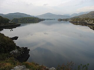
WUpper Lake is a lake in Killarney National Park, County Kerry, Ireland. It is one of the Lakes of Killarney, along with Muckross Lake and Lough Leane.
 W
WThe Uragh Stone Circle is a stone circle near Gleninchaquin Park, Tuosist, County Kerry, Ireland.