 W
WArrën is a village and a former municipality in Kukës County, Albania. At the 2015 local government reform it became a subdivision of the municipality Kukës. The population at the 2011 census was 462. The municipal unit consists of the following villages:Arrën Arrëz Barrë Vërrij Tejmoll
WBicaj is a village and a former municipality in Kukës County, Albania. At the 2015 local government reform it became a subdivision of the municipality Kukës. The population at the 2011 census was 5,631. The municipal unit consists of the following villages:Bushat Bicaj Osmane Muholë Mustafë Nangë Kolesian Domaj Gabricë Tërshen Bushat
 W
WBogićevica is a mountain area in the Prokletije. It spreads over Albania, Montenegro and Kosovo. It is about 15 km (9 mi) long and 10 km (6 mi) wide. The mountain area has a number of peaks higher than 2,000 m (6,562 ft) and two higher than 2,500 m (8,202 ft). Marijaš and Maja e Ropës are both located in Kosovo. The towns of Deçan in Kosovo and Tropojë in Albania are located near the area.
 W
WBujan is a village and a former municipality in the Kukës County, northern Albania. At the 2015 local government reform it became a subdivision of the municipality Tropojë. The population at the 2011 census was 2,550. It is known for hosting the 1943 Bujan Conference.
WBushtricë is a village and a former municipality in Kukës County, Albania. At the 2015 local government reform it became a subdivision of the municipality Kukës. The population at the 2011 census was 1,486. The municipal unit consists of the following villages:Bushtricë Gjegje Matranxhë Palush Vilë Barruq Shpat
WBytyç is a former municipality in the Kukës County, northern Albania. At the 2015 local government reform it became a subdivision of the municipality Tropojë. The population at the 2011 census was 1,563.
 W
WThe Drin Valley is a valley in northern and eastern Albania along the Drin River.
WFajzë is a village and a former municipality in the Kukës County, northeastern Albania. At the 2015 local government reform it became a subdivision of the municipality Has. The population at the 2011 census was 3,491.
 W
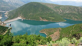
WThe Fierza Reservoir is a reservoir in Albania and Kosovo. The Drin River and parts of the White Drin and Black Drin also runs through the reservoir. The size of the lake is 72.6 km2 (28.0 sq mi), of which 2.46 km² belong to Kosovo. It is 70 km long and has a depth of 128 m. In the Albanian side of the lake there are many canyons and some small islands. The dam is 167m tall. In 2014, the lake was declared a Regional Nature Park by the Kukes County Council.
 W
WFierzë is a town and a former municipality in the Kukës County, northern Albania. At the 2015 local government reform it became a subdivision of the municipality Tropojë. Fierzë sits on both banks of the Drin, which here forms the boundary between Fushë-Arrëz and Tropojë.
WGjinaj is a village and a former municipality in the Kukës County, northeastern Albania. At the 2015 local government reform it became a subdivision of the municipality Has. The population at the 2011 census was 1,106.
WGolaj is a village and a former municipality in the Kukës County, northeastern Albania. At the 2015 local government reform it became a subdivision of the municipality Has. The population at the 2011 census was 6,187.
WGrykë-Çajë is a former municipality in Kukës County, Albania. At the 2015 local government reform it became a subdivision of the municipality Kukës. The population at the 2011 census was 1,440. It is located between two rivers that flow into the Black Drin river, at the foot of Mount Korab. Nine Halveti structures lie in the municipality's borders. The municipal unit consists of the following villages:Fshat Çajë Buzëmadhe Shkinak
WHas is a municipality in Kukës County, northeastern Albania. It was created in 2015 by the merger of the former municipalities Fajzë, Gjinaj, Golaj and Krumë. The seat of the municipality is the town Krumë. The total population is 16,790, in a total area of 400.01 km2. It is coterminous with the former Has District, and the ethnographic Has region.
 W
WThe Junik Mountains, part of the Prokletije range, are on the border between Albania and Kosovo. They reach a height of 2,280 m (7,480 ft). On the Kosovan side are located in the Metohija region, some 8.5 km (5 mi) to the north-west of the Junik commune.
 W
WKalabak (Halabak) Albanian: Maja e Kallabakut is a mountain belonging to the Šar Mountains, located in Albania and Kosovo. Kalabak's height is 2,174 m (7,133 ft) above sea level and is located near the southern tip of Kosovo. Kalabak and its surroundings are treeless so it is an ideal places for shepherds to raise their sheep and the Šarplaninac as the protector.
WKalis is a village and a former municipality in Kukës County, Albania. At the 2015 local government reform it became a subdivision of the municipality Kukës. The population at the 2011 census was 827. The municipal unit consists of the following villages:Kalis Gështenjë Kodër-Gështenjë Gurr Pralish
WKollovoz is a village in the former Shishtavec municipality in Kukës County, Albania. At the 2015 local government reform it became part of the municipality Kukës.
WKolsh is a village and a former municipality in Kukës County, Albania. At the 2015 local government reform it became a subdivision of the municipality Kukës. The population at the 2011 census was 1,250. The municipal unit consists of the following villages:Kolsh Mamëz Myç-Mamëz
 W
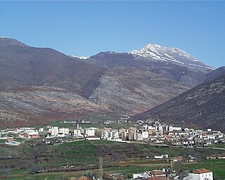
WKrumë is a town and a former municipality in the Kukës County, northern Albania. At the 2015 local government reform it became a subdivision and the seat of the municipality Has. The population according to the 2011 census was 6,006. It was the seat of the former Has District.
 W
WKukës District was one of the thirty-six districts of Albania. It had a population of 64,054 in 2001, and an area of 956 km². The town of Kukës was where the district's administrative headquarters were located. Its territory is now part of Kukës County, and is coterminous with the present municipality of Kukës.
 W
WLake Dash is a mountain lake in Albania. It is located in the Prokletije, near the border with Kosovo. It is one of the largest lakes found in the mountain range with an area a little more than 3.5 hectares. In English, Liqeni i Dashit means "Stag's Lake".
WLekbibaj is a village and a former municipality Tropojë northern Albania. At the 2015 local government reform it became a subdivision of the municipality Tropojë. The population at the 2011 census was 1,207. It is the historical center of the Nikaj-Mërturi region.
WLiqeni i Dhenve is a small mountain lake in the north of Albania. Dhenve lake is situated in the Prokletije range near to the border with Kosovo. Dhenve Lake is a round lake, and the river that originates from it flows down into the Gashi River. It has a surface area of approximately 0.8 hectares.
WLlugaj is a village and a former municipality in the Kukës County, northern Albania. At the 2015 local government reform it became a subdivision of the municipality Tropojë. The population at the 2011 census was 1,787.
WLumë is a village in the former Shtiqën Municipality, Kukës County, Albania, beside the Kirit River. At the 2015 local government reform it became part of the municipality Kukës. It is about 21 kilometres (13 mi) northwest of Shkodër by road.
 W
WMaja Bogiçaj is a peak of the Prokletije. It is located on the border of Kosovo and Albania. Bogiçaj is part of the Bogićevica mountain area and its peak is 2,405 m (7,890 ft) above sea level. One of the closest peaks is Tromeđa which is just found north-west of Bogiçaj peak.
WMaja Briaset is a 2,567 m (8,422 ft) tall mountain located in the country of Albania. It is part of the Prokletije in the northern part of Albania. One of the surrounding valleys is Valbona Valley.
 W
WMaja e Hekurave is a mountain in the Bjeshkët e Namuna in the country of Albania. At 2,561 m (8,402 ft), it is one of the highest peaks in the mountain range. Maja Hekurave is a popular tourist spot.
 W
WMaja e Kakisë a mountain in the north of Albania. Maja e Kakisë is 2,357m high. It is located in the south of the large Prokletije not far from the smaller Maja e Ershellit which is found even more towards the south bordering the long Drin River.
 W
WMaja e Popljuces is a mountain in Albania in the Prokletije. It is 2,569 m (8,428 ft) high and it itself is surrounded by many peaks above 2,500 m (8,200 ft). It is located just south of Maja Jezercë.
 W
WMaja Grykat e Hapëta is a mountain located in northern Albania in the Bjeshkët e Namuna. It is found to the southeast of Maja Jezercë, south of the upper Valbonë valley. It is one of the highest mountains in the mountain range at 2,625 m (8,612 ft) high. In fact, it is the third highest after Maja Jezercë at 2,694 m (8,839 ft) in Albania and Đeravica at 2,656 m (8,714 ft) in Kosovo. Like many of the other mountains surrounding it, Maja Grykat e Hapëta has a stony texture near its summit. Maja Grykat e Hapëta belongs to the group of peaks called Majet e Zabores where there are 10 peaks that are higher than 2,400 m (7,874 ft).
WMalzi is a former municipality in Kukës County, Albania. At the 2015 local government reform it became a subdivision of the municipality Kukës. The population at the 2011 census was 3,072. The municipal unit consists of the following villages:Shëmri Shtanë Petkaj Megullë Camë Gdheshtë Pistë Va Spas Shikaj Dukagjin Kalimash Kryemadh Simon
WMargegaj is a village and a former municipality in the Kukës County, northern Albania. At the 2015 local government reform it became a subdivision of the municipality Tropojë. The population at the 2011 census was 2,346. The Valbonë River valley and the village Valbonë are located in the municipality.
WMorinë is a settlement in eastern Albania, on the border with Kosovo. The Kosovo side of the border is Vërmica. At the 2015 local government reform it became part of the municipality Kukës.
WPac is a village located in the administrative territorial entity of Bytyç, belonging to the municipality of Tropojë, in northern Albania.
 W
WPaštrik or Pashtrik, is a mountain located in Kosovo and Albania. Its highest peak is located on their mutual border, it is also called Paštrik and it is 1,986 m (6,516 ft) high. The White Drin river passes along by it. Mount Pashtrik is the site of annual pilgrimages of residents from Has region of Prizren and Gjakova in Kosovo and from the border area of Albania.
WShishtavec is a former municipality in Kukës County, Albania. At the 2015 local government reform it became a subdivision of the municipality Kukës. The population at the 2011 census was 3,835.
 W
WShkëlzen is a mountain in Albania with a height of 2,404 metres (7,887 ft). It is rocky and located near the border with Kosovo, north of Tropojë. It belongs to the Prokletije. Shkëlzen shares its name with a village that is just south of the mountain.
WShtiqën is a village and a former municipality in Kukës County, Albania. At the 2015 local government reform it became a subdivision of the municipality Kukës. The population at the 2011 census was 3,438. The municipal unit consists of the following villages:Shtiqën Krenxë Lumë Gjalicë
WSurroj is a village and a former municipality in Kukës County, Albania. After the 2015 local government reform it became a subdivision of the municipality Kukës. The population at the 2011 census was 1,099. The municipal unit consists of the following villages:Surroj Çinamakë Fusharrë Aliaj
WTërthore is a former municipality in Kukës County, Albania. At the 2015 local government reform it became a subdivision of the municipality Kukës. The population at the 2011 census was 2,959.
 W
WTopojan is a village and a former municipality in Kukës County, Albania. It became a subdivision of the municipality Kukës at the 2015 local government reform. The population at the 2011 census was 1,753.
WTromedja is a mountain in the Bogićevica area in the Prokletije range. Its peak which measures a height of 2,366 m (7,762 ft) above sea level forms a boundary between Albania, Kosovo and Montenegro. Albania contains the south of the mountain which is the majority of it, Kosovo the north-east and Montenegro the north-west. There is a valley in the Albanian and Kosovan side of the mountain. The village of Debërdol in Albania is located quite close to the summit.
WUjmisht is a village and a former municipality in Kukës County, northeastern Albania. At the 2015 local government reform it became a subdivision of the municipality Kukës. The population at the 2011 census was 1,797.
WValbonë is a village in the Kukës County, northern Albania. It is part of the former municipality Margegaj, and situated in the valley of the river Valbonë, south of the mountain Maja e Thatë. At the 2015 local government reform it became part of the municipality Tropojë. As one of the main settlements of Valbonë Valley National Park, it provides appropriate accommodation for visitors and tourists, mostly in typical alpine houses or inns.
WViçidol is a village in the Kukës County, northern Albania. At the 2015 local government reform it became part of the municipality Tropojë. It is located 2.4 kilometres (1.5 mi) away from the town of Tropojë and 4.6 kilometres (2.9 mi) from the border with Kosovo.
WZahrisht is a village in Kukës County, northeastern Albania. At the 2015 local government reform it became part of the municipality Has.
WZapod is a village and a former municipality in Kukës County, northeastern Albania. At the 2015 local government reform it became a subdivision of the municipality Kukës. The administrative unit of Zapod contains the villages Orgjost, Kosharisht, Pakisht, Zapod and Orçikël which are populated by Slavic Muslims, called Gorani, that are speaking Torlakian, while the villages of Bele and Lojmë are inhabited by Albanians. As of the 2011 census, the municipality had 2,217 residents, of whom 80% declared as ethnic Albanians and 11.7% declared as ethnic Macedonians.