 W
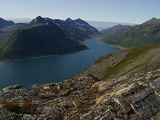
WArnøya (Norwegian) or Árdni (Northern Sami) is the 15th largest island in Norway. The 276-square-kilometre (107 sq mi) island is located in Skjervøy Municipality in Troms og Finnmark county. The highest peak is the 1,168-metre (3,832 ft) tall mountain Arnøyhøgda. There are regular ferry connections to the island from the nearby islands of Laukøya and Kågen, but there are no road connections to the island. Arnøy Church is located on the southern shore of the island.
 W
WÅrøya is an island of northern Norway, located off the coast of Alta, in Troms og Finnmark county. It covers an area of 6.38 square kilometres (2.46 sq mi) and contains the remains of Altenhus Fortress (Kongshus), built in 1610. There is a ferry connection between the village of Kongshus on Årøya and Mikkelsby on the mainland.
 W
WBjarkøya is an island in Harstad Municipality in Troms og Finnmark county, Norway. The 14.6-square-kilometre (5.6 sq mi) island is located north of the island of Grytøya and northwest of the island of Sandsøya. The Andfjorden lies to the northwest and the Vågsfjorden lies to the southeast. The main church for the island is Bjarkøy Church in the village of Nergården. The island's population (2017) is 267.
 W
WDyrøya is an island in Dyrøy Municipality in Troms og Finnmark county, Norway. The 53-square-kilometre (20 sq mi) island is located between the large island of Senja and the mainland of Norway. The Dyrøysundet strait lies to the east of the island and the Tranøyfjorden lies to the north and west. The island of Andørja lies about 7 kilometres (4.3 mi) south of Dyrøya.
 W
WGressholman or Grasholmen is an island in Harstad Municipality in Troms og Finnmark county, Norway. It is part of a small archipelago of several islets just outside the town of Harstad along the Vågsfjorden, at the northern end of the Tjeldsundet strait. The village of Fauskevåg lies on the large island of Hinnøya, just west of Grasholmen. The islets are popular recreational areas, especially in the summer.
 W
WHåja (Norwegian) or Jievju (Northern Sami) is an unpopulated island in Hammerfest Municipality in Troms og Finnmark county, Norway. Håja is located in the Sørøysundet strait, between the larger islands of Kvaløya to the east, Seiland to the south, and Sørøya to the northwest. The town of Hammerfest lies about 8 kilometres (5.0 mi) to the east of Håja.
 W
WHåkøya is an island in Tromsø Municipality in Troms og Finnmark county, Norway. The 3.69-square-kilometre (1.42 sq mi) island is located in the Sandnessundet strait between the islands Kvaløya and Tromsøya. It is southeast of the village of Eidkjosen on Kvaløya and west of the city of Tromsø on Tromsøya.
WHavøya is an island in Måsøy Municipality in Troms og Finnmark county, Norway. The island lies just off the coast of the Porsanger Peninsula with the island of Hjelmsøya to the north, Måsøya to the east, and Rolvsøya to the west. The only village on the island is Havøysund on the southern part of the island. Havøysund is the administrative centre of Måsøy Municipality, and it is the main population centre of the municipality. The island is connected to the mainland by the Havøysund Bridge along Norwegian County Road 889.
 W
WHelgøya is an island and former fishing village in Karlsøy Municipality in Troms og Finnmark county, Norway. The 42.92-square-kilometre (16.57 sq mi) island is surrounded by a number of islands: Vannøya to the northeast; Karlsøya and Reinøya to the southeast; Ringvassøya to the south; and Nordkvaløya to the west.
WHillesøya is an island and fishing village in Tromsø Municipality in Troms og Finnmark county, Norway. The 1.8-square-kilometre (0.69 sq mi) island is dominated by a mountain, but the southeastern third of the island is relatively flat and that is where the residents of the island live. In 2018, there were 25 inhabitants on the island. The island lies just north of the island of Store Sommarøya and it is connected by the Hillesøy Bridge to Sommerøy which in turn is connected to the large island of Kvaløya and the rest of Norway by another bridge.
WHjelmsøya is an island in Måsøy Municipality in Troms og Finnmark county, Norway. The 39-square-kilometre (15 sq mi) island lies west of the islands of Måsøya and Magerøya, north of Havøya and the mainland, and east of Ingøya. The mountainous island has been uninhabited since 1967. There are connections to the island other than by private boats.
 W
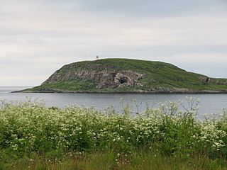
WHornøya is a small, 0.4 square kilometres, uninhabited island in Vardø Municipality in Troms og Finnmark county, Norway. It lies in the Barents Sea, just east of the larger island of Vardøya where the town of Vardø is located. Vardø Lighthouse is situated at the highest point of the island, at an elevation of 65 metres (213 ft) above sea level, and it protects the shipping lanes around the town of Vardø. The island is the easternmost point of Norway proper.
 W
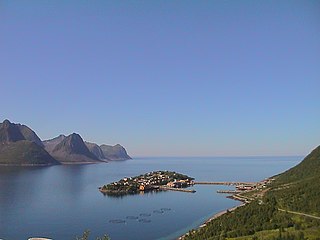
WHusøy is a village in Senja Municipality in Troms og Finnmark county, Norway. The village covers the entire island of Husøy which is located in the Øyfjorden off the northwest coast of the large island of Senja. The village/island is located about 53 kilometres (33 mi) southwest of the city of Tromsø. The village of Fjordgård sits about 4 kilometres (2.5 mi) across the fjord on the island of Senja.
 W
WIngøya is an island on the edge of the Arctic Ocean in Måsøy Municipality in Troms og Finnmark county, Norway. The 18-square-kilometre (6.9 sq mi) island lies just north of the island of Rolvsøya and west of the island of Hjelmsøya. The sparsely populated island is only accessible by boat. There are regular ferry connections at the port in the village of Ingøy on the north side of the island. The ferry connects to Gunnarnes on Rolvsøya and Havøysund on the island of Havøya. The island has about 13 inhabitants (2018). The Ingøy radio transmitter is located about 2 kilometres (1.2 mi) south of the village of Ingøy. Fruholmen Lighthouse lies just off the northern coast of the island.
 W
WKågen (Norwegian) or Gávvir (Northern Sami) is an island in Skjervøy Municipality in Troms og Finnmark county, Norway. The 85.7-square-kilometre (33.1 sq mi) island lies between the Kvænangen fjord and the Lyngen fjord to the west. The island is home to 27 inhabitants (2001). The island is mountainous with several peaks over 1,000 metres (3,300 ft) above sea level. The highest point is the 1,228-metre (4,029 ft) tall mountain Store Kågtind. Kågen is the 52nd largest island in Norway.
 W
WKarlsøya is an island in Karlsøy Municipality in Troms og Finnmark county, Norway. The 7.91-square-kilometre (3.05 sq mi) island of Karlsøya lies directly south of the island of Vannøya and northeast of the island of Reinøya, along the western side of the Ullsfjorden. The one village area on the island is known as Karlsøy and in 2001, it had a population of 70.
 W
WKrøttøya is an island in Harstad Municipality in Troms og Finnmark county, Norway. The 1.3-square-kilometre (0.50 sq mi) island is the northernmost inhabited island in the Andfjorden. It is located in the Meløyvær archipelago, consisting of 365 small islands, with over 20 white-sand beaches. Several other islands are connected to Krøttøya by road, but the island group is only accessible by boat. Krøttøy is surrounded by the large islands of Senja to the east, Bjarkøya and Grytøya to the south, and Andøya to the west.
 W
WKvæøya is an island in Kvæfjord Municipality in Troms og Finnmark county, Norway. It is located in the Kvæfjorden, an arm of the Gullesfjorden. The island sits about 1.5 kilometres (0.93 mi) southwest of the village of Borkenes. In 2010, the Kvæøy Bridge was completed, connecting the village of Hundstad on the island to a point just west of the village of Straumen on the main island of Hinnøya.
WKvaløya is a large island in Troms og Finnmark county, Norway. The 336-square-kilometre (130 sq mi) island is located in Hammerfest Municipality. The town of Hammerfest is located in the western shore of the island. Other villages on the island include Forsøl, Rypefjord, and Stallogargo.
 W
WLaukøya (Norwegian) or Unna Ártnás (Northern Sami) is an island in Skjervøy Municipality in Troms og Finnmark county, Norway. The island of Arnøya is immediately to the west of Laukøya, the Kvænangen fjord lies to the east, and the islands of Kågen and Skjervøya lie to the south. There is a regular ferry connection between Laukøya, Kågen, and Arnøya, but no road connections.
WLille-Kamøya is an uninhabited mountainous island in Hammerfest Municipality in Troms og Finnmark county, Norway. The island is north of the islands of Kamøya and Sørøya and has an area of about 0.6 square kilometres (0.23 sq mi). The highest point on the island is the 222-metre (728 ft) tall mountain Litlestauren.
WLille Kamøya is a small island in Nordkapp Municipality in Troms og Finnmark county, Norway. It is located just off the eastern coast of the large island of Magerøya. It lies where the Duksfjorden meets the Kamøyfjorden, just to the northwest of the island of Store Kamøya and to the north of the fishing village of Kamøyvær. The island helps to shelter Kamøyvær's harbour from the open sea.
 W
WMåsøya is an island in Måsøy Municipality in Troms og Finnmark county, Norway. The 13.45-square-kilometre (5.19 sq mi) island is located west of the large island of Magerøya and to the east of the islands of Hjelmsøya and Havøya. The Porsanger Peninsula on the mainland lies south of the island. The island is only accessible by boat, and there is regular ferry service from Havøysund. The population of the island (2012) is about 40 people.
 W
WNord-Fugløya or Fugløya is an uninhabited island in Karlsøy Municipality in Troms og Finnmark, Norway. The 21.3-square-kilometre (8.2 sq mi) island is protected as a nature reserve. The highest mountain is the 750-metre (2,460 ft) tall Fugløykallen. Fugløykalven Lighthouse is located north of the island.
 W
WNordkvaløya is an island in Karlsøy Municipality in Troms og Finnmark county, Norway. The island is situated north of the islands of Ringvassøya and west of Helgøya. The Norwegian Sea borders to the northwest. The 84.4-square-kilometre (32.6 sq mi) island of Nordkvaløya is very rugged and mountainous. The highest point is Storalangen at 736 m (2,415 ft). In 2017, the island had 3 residents.
 W
WRebbenesøya (Norwegian) or Ruobbá (Northern Sami)) is an island in Troms og Finnmark county, Norway. The southern third of the 80.6-square-kilometre (31.1 sq mi) island is part of Tromsø Municipality while the northern (larger) portion of the island is part of Karlsøy Municipality. There is a regular ferry connection from Bromnes on the eastern end on Rebbensøya to Mikkelvik on the northwestern end of the neighboring island of Ringvassøya.
 W
WReinøya is an island in Karlsøy Municipality in Troms og Finnmark county, Norway. The 147-square-kilometre (57 sq mi) lies directly east of the large island of Ringvassøya, and the small island of Karlsøya lies to the north of the island. The Ullsfjorden lies along the eastern coast of the island.
 W
WReinøya is an island in the municipality of Vardø in Troms og Finnmark, Norway. It is located west of Hornøya. Reinøya has a rich birdlife.
 W
WRingvassøya (Norwegian) or Ráneš (Northern Sami) is a large island in Troms og Finnmark county, Norway. It is divided between the municipalities of Tromsø and Karlsøy. Several islands surround Ringvassøya including Kvaløya to the south; Reinøya and Karlsøya to the east; Vannøya, Helgøya, and Nordkvaløya to the north; and Rebbenesøya to the north west. The island is connected to the neighboring island by the Kvalsund Tunnel on the south shore of the island.
WRolvsøy or Rolvsøya is an island in Måsøy Municipality in Troms og Finnmark county, Norway. The 89-square-kilometre (34 sq mi) island has a population (2001) of 72. The island is located south of the island of Ingøya and north and west of the mainland, separated by the Rolvsøysundet.
 W
WRolla (Norwegian) or Rálli (Northern Sami) is an island in Ibestad Municipality in Troms og Finnmark county, Norway. The island of Andørja lies to the northeast, the Vågsfjorden lies to the north and west, and the Astafjorden lies to the south. The highest point on the 106-square-kilometre (41 sq mi) island of Rolla is Drangen at a height of 1,022 metres (3,353 ft). The population on Rolla (2001) is 1,078.
 W
WSandsøya or Sandsøy is an island in Harstad Municipality in Troms og Finnmark county, Norway. The 10.8-square-kilometre (4.2 sq mi) island lies east of the island of Grytøya and southeast of the island of Bjarkøya. The highest point on the island is the 212-metre (696 ft) mountain Veten. In 2017, Sandsøya had 91 inhabitants.
 W
WSeiland is the eighth largest island in mainland Norway, located in Troms og Finnmark county. The 583-square-kilometre (225 sq mi) island is divided between the municipalities of Alta and Hammerfest
 W
WSilda is an uninhabited island in Loppa Municipality in Troms og Finnmark county, Norway. The 48-square-kilometre (19 sq mi) island lies in the Lopphavet Sea, north of the villages of Bergsfjord and Sør-Tverrfjord on the mainland. The island is very mountainous, the tallest being the 628-metre (2,060 ft) tall mountain Sunnáčohkka. The name of the island may be derived from the Norwegian words for "seal" or "herring".
 W
WSkjervøya (Norwegian) or Skiervá (Northern Sami) is an island in Skjervøy Municipality in Troms og Finnmark county, Norway. The 11.7-square-kilometre (4.5 sq mi) island lies to the east of the island of Kågen and south of the island of Laukøya. The Kvænangen fjord lies to the east of the island. The village of Skjervøy is the main population centre on the island. Fishing is one of the main industries on the island. Skjervøya is connected to the mainland by a bridge and then a tunnel. The Skjervøy Bridge connects the island to Kågen island to the west. The undersea Maursund Tunnel the connects Kågen to the mainland.
 W
WSkogerøya is an uninhabited island in Sør-Varanger municipality in Troms og Finnmark county, Norway. The 129-square-kilometre (50 sq mi) partially forested island lies south of the Varangerfjorden, west of the Bøkfjorden, north of the Korsfjorden, and east of the Kjøfjorden. The highest point on the island is the 445-metre (1,460 ft) tall Skogerøytoppen. The island lies about 10 kilometres (6.2 mi) northwest of the town of Kirkenes. It is used as a summer and autumn grazing area for reindeer.
 W
WSkorpa (Norwegian) or Skárfu (Northern Sami) is an uninhabited island in Kvænangen Municipality in Troms og Finnmark county, Norway. The 8.26-square-kilometre (3.19 sq mi) island is located in the middle of the Kvænangen fjord, south of the island of Spildra. The last permanent resident of the island moved off the island around 1980, and the island has had no permanent inhabitants since then. It is only accessible by boat.
 W
WSpildra (Norwegian) or Spittá (Northern Sami) is an island in Kvænangen Municipality in Troms og Finnmark county, Norway. The 21.4-square-kilometre (8.3 sq mi) island lies in the middle of the Kvænangen fjord, about 5 kilometres (3.1 mi) north of the island of Skorpa. The island has a population (2017) of 26 people, with everyone living along the southern coast. The only access to the island is by boat. The population has been declining over time. The main economic activities on the island center around the production of Boknafisk as well as tourism.
WStjernøya is an island in western Troms og Finnmark county, Norway. The 248.1-square-kilometre (95.8 sq mi) island sits at the mouth of the Altafjorden on the south side of the Sørøysundet strait. It is divided among the municipalities of Loppa, Hasvik, and Alta. The highest point on the island is the 960-metre (3,150 ft) tall mountain Kjerringfjordfjellet. One of the larger fjords on the island is the Sørfjorden. There were 80 residents on the mountainous island in 2012. The main population area is at the village of Store Kvalfjord on the northeastern side of the island. On the southern part of the island there is a large nepheline syenite mine at Lillebukt. The island is separated from the mainland by the strait of Stjernsundet.
WKamøya is an uninhabited island in Hammerfest Municipality in Troms og Finnmark county, Norway. The 4.3-square-kilometre (1.7 sq mi) island is north of the large island of Sørøya and just a little south of Lille Kamøya. The island is home to many bird cliff nesting areas.
 W
WStore Kamøya is a small island in Nordkapp Municipality in Troms og Finnmark county, Norway. It is located off the eastern coast of the large island of Magerøya where the Kamøyfjorden splits into the Duksfjorden and Skipsfjorden. It lies just to the southeast of the island of Lille Kamøya and to the east of the fishing village of Kamøyvær, helping to shelter the latter's harbour from the open sea.
WTjeldøya (Norwegian) or Dielddasuolu (Northern Sami) is an island in Troms og Finnmark county, Norway. The 187-square-kilometre (72 sq mi) island is located entirely in Tjeldsund Municipality. North and west of the island lies the Tjeldsundet strait which separates it from the large island of Hinnøya; south of the island is the Ofotfjorden; and east of the island lies the Ramsundet strait which separates it from the mainland of Norway. Tjeldøya is connected to the mainland by the Ramsund Bridge, about 7 kilometres (4.3 mi) south of the village of Hol.
 W
WTranøya is an island in Senja Municipality in Troms og Finnmark county, Norway. It is located in the Solbergfjorden, about 1 kilometre (0.62 mi) south of the large island of Senja. The 1.18-square-kilometre (0.46 sq mi) island is almost totally uninhabited. There is one farm area on the eastern side of the island. The farm is also the site of the historic Tranøy Church. Today the farm is owned by the local government and used as a retirement and assisted living facility. There is also a small museum on the site.
 W
WTromsøya (Norwegian) or Romssasuolu (Northern Sami) is a small island in Tromsø Municipality in Troms og Finnmark county, Norway. The 21.7-square-kilometre (8.4 sq mi) island lies in the Tromsøysundet strait between the mainland and the large island of Kvaløya. The city of Tromsø is located on the island. The island has about 39,882 residents which gives the island a population density of about 1,838 inhabitants per square kilometre (4,760/sq mi).
 W
WUløya (Norwegian) or Ulisuolu (Northern Sami) is an island in Troms og Finnmark county, Norway. The island is situated on the east side of the Lyngen fjord and it is divided between Skjervøy and Nordreisa municipalities. The island has an area of 78 km2 (30 sq mi), and the highest point is Blåtinden at 1,142 m (3,747 ft). The population (2001) on the Skjervøy part of the island is 29, and the population (2001) on the Nordreisa part is 65. The two sides of the island are not connected by road.
 W
WVadsøya is an island in Vadsø Municipality in Troms og Finnmark county, Norway. The island lies in the Varangerfjorden, just south of the coast of the mainland Varanger Peninsula. The island is part of the town of Vadsø. The 0.8-square-kilometre island is connected to the mainland by a bridge that branches off the European route E75 highway in the centre of the town of Vadsø. The Hurtigruten coastal express boats dock on Vadsøya.
 W
WVanna or Vannøya is a rocky island in Karlsøy Municipality in Troms og Finnmark county, Norway. At 232 square kilometres (90 sq mi), Vanna is the 17th largest island in Norway by area. The highest peak is the mountain Vanntinden at a height of 1,031 metres (3,383 ft) above sea level. The population of the island (2017) is 799. Vannvåg and Vannareid are the two main population centres on the island. Sengskroken Church is located on the western coast of the island.
 W
WVardøya is an island in Vardø Municipality in Troms og Finnmark county, Norway. The 3.7-square-kilometre (1.4 sq mi) island is the location of the town of Vardø. The island sits about 1.5 kilometres (0.93 mi) east of the mainland Varanger Peninsula. The island is connected to the mainland by the Vardø Tunnel, the first subsea tunnel that was built in Norway. The tunnel is part of the European route E75 highway, which has its terminus at the town of Vardø. The small island of Hornøya is located just 1.5 kilometres (0.93 mi) to the northeast of Vardøya.
 W
WVorterøya is an island located in Skjervøy Municipality in Troms og Finnmark county, Norway. Vorterøya is located along the Lyngen fjord to the east of Kågen island and to the north of Uløya island. There are about 10 residents on the island who live there year-round. Many other residents live there in the summer months, but spend the winters elsewhere.