 W
WThe Jerusalem Subdistrict was one of the subdistricts of Mandatory Palestine. It was located in and around the city of Jerusalem. After the 1948 Arab–Israeli War, the district was integrated into the Jerusalem District.
 W
WAl-Burayj was a Palestinian Arab village in the Jerusalem Subdistrict. It was depopulated during the 1948 Arab–Israeli War on October 19, 1948, during the first phase of Operation Ha-Har. The village was located 28.5 km west of Jerusalem.
 W
WAl-Jura was a Palestinian Arab village in the Jerusalem Subdistrict. It was depopulated during the 1948 Arab-Israeli War on July 11, 1948, under Operation Danny. It was located 8.5 km west of Jerusalem. al-Jura was mostly destroyed with the exception of several deserted houses.
 W
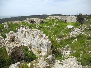
WAl-Qabu, was a Palestinian Arab village in the Jerusalem Subdistrict. The name is an Arabic variation of the site's original Roman name, and the ruins of a church there are thought to date to the era of Byzantine or Crusader rule over Palestine.
 W
WAllar or 'Allar el-Fawqa, also known as 'Allar el Busl, was a Palestinian Arab village located southwest of the Old City of Jerusalem near Wadi Surar, along Wadi Tannur. The name was shared by the twin village of Allar al-Sifla or Khirbat al-Tannur, with official imperial ledgers often listing them both under the single entry of Allar.
 W
WAqqur was a Palestinian Arab hamlet in the Jerusalem Subdistrict. It was depopulated during the 1948 Arab-Israeli War on July 13, 1948, under Operation Dani. It was located 14.5 km west of Jerusalem on the Wadi Isma'il, a tributary of the Wadi al-Sarar.
 W
WArtuf was a Palestinian village in the Jerusalem foothills depopulated in 1948. It was situated 21.5 kilometers (13.4 mi) west of Jerusalem on a high plateau, surrounded by plains on the south, east, and west. The village was on a secondary road that linked it to the main road to Jerusalem.
 W
WBayt ʿIṭāb was a Palestinian Arab village located in the Jerusalem Subdistrict. The village is believed to have been inhabited since biblical times. An ancient tunnel which led to the village spring is associated with story of Samson. Both during and after its incorporation into Crusader fiefdoms in the 12th century, its population was Arab. Sheikhs from the Lahham family clan, who were associated with the Qays tribo-political faction, ruled the village during Ottoman era. In the 19th century, this clan controlled 24 villages in the vicinity. The homes were built of stone. The local farmers cultivated cereals, fruit trees and olive groves and some engaged in livestock breeding.
 W
WBayt Mahsir was a Palestinian Arab village in the Jerusalem Subdistrict. It was depopulated during the 1947–48 Civil War in Mandatory Palestine on May 10, 1948 by the Harel Brigade of Operation Makkabi. It was located 9 km west of Jerusalem.
 W
WBayt Naqquba was a Palestinian village in British Mandate Palestine, located 9.5 kilometers west of Jerusalem, near Abu Ghosh. Before Palmach and Haganah troops occupied the village during Operation Nachshon on April 11, 1948 approximately 300 Palestinian Arabs lived there. After the 1948 Arab–Israeli War, a moshav named Beit Nekofa was founded close to the site by Jewish immigrants from Yugoslavia. In 1962, residents of Bayt Naqubba built a new village named Ein Naqquba, south of Beit Nekofa.
 W
WBayt Nattif or Beit Nattif was a Palestinian Arab village, located some 20 kilometers southwest of Jerusalem, midway on the ancient Roman road between Beit Guvrin and Jerusalem, and 21 km northwest of Hebron.
 W
WBayt Thul was a Palestinian village in the Jerusalem Subdistrict. It was depopulated during the 1947–1948 Civil War in Mandatory Palestine on April 1, 1948 under Operation Nachshon. It was located 15.5 km west of Jerusalem.
 W
WBayt Umm al-Mays was a small Palestinian Arab village in the Jerusalem Subdistrict. It was depopulated during the 1948 Arab-Israeli War on October 21, 1948 by the Har'el Brigade of Operation ha-Har. It was located 14 km west of Jerusalem.
 W
WDayr 'Amr was a Palestinian Arab village in the Jerusalem Subdistrict. It was depopulated during the 1948 Arab-Israeli War on July 17, 1948 by the Fourth Battalion of the Har'el Brigade, during the second stage of Operation Dan. It was located 12.5 km west of Jerusalem. Dayr 'Amr was named after a local sage known by al-Sa'i 'Amr and a shrine was in the village dedicated to him.
 W
WDayr Aban was a Palestinian Arab village in the Jerusalem Subdistrict, located on the lower slope of a high ridge that formed the western slope of a mountain, to the east of Beit Shemesh. It was formerly bordered by olive trees to the north, east, and west. The valley, Wadi en-Najil, ran north and south on the west-side of the village. It was depopulated during the 1948 Arab-Israeli War on October 19, 1948, during Operation Ha-Har. It was located 21 km west of Jerusalem.
 W
WDayr al-Hawa was a Palestinian Arab village in the Jerusalem Subdistrict. The village was depopulated during the 1948 Arab-Israeli War on October 19, 1948 by the Fourth Battalion of the Har'el Brigade of Operation ha-Har. It was located 18.5 km west of Jerusalem.
 W
WDayr al-Shaykh, also spelt Deir esh Sheikh, was a Palestinian Arab village in the Jerusalem Subdistrict, also known as the Jerusalem corridor. It was depopulated during the 1948 Arab-Israeli War. The village was located 16 kilometers (9.9 mi) west of Jerusalem.
 W
WDayr Rafat was a Palestinian Arab village in the Jerusalem Subdistrict. It was located 26 km west of Jerusalem. It was depopulated during the 1948 Arab–Israeli War by the Harel Brigade.
 W
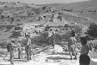
WDeir Yassin was a Palestinian Arab village of around 600 inhabitants about 5 kilometers (3.1 mi) west of Jerusalem. Deir Yassin declared its neutrality during the 1948 Palestine war between Arabs and Jews. The village was razed after a massacre of around 107 of its residents on April 9, 1948, by the Jewish paramilitary groups Irgun and Lehi. The village buildings are today part of the Kfar Shaul Mental Health Center, an Israeli public psychiatric hospital.
 W
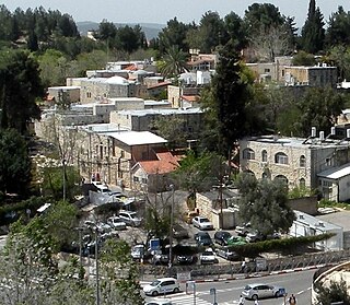
WEin Karem is an ancient village southwest of historical Jerusalem, and now a neighborhood of the modern city, within Jerusalem District, Israel. It is the site of the Hadassah Medical Center. It was a Palestinian village in Mandatory Palestine's Jerusalem Subdistrict, depopulated during the 1948 Arab-Israeli War on July 16, 1948.
 W
WIshwa' was a Palestinian village which was depopulated during the 1948 Arab-Israeli war. The village was located about 20 km west of Jerusalem, on the present location of Eshta'ol. In the 1931 British census of Palestine, Ishwa had a population of 468 in 126 houses. The village was occupied by the Israel Defense Forces (IDF) on July 16, 1948 in Operation Dani by the Harel Brigade. All of its inhabitants fled or were expelled.
 W
WIslin was a Palestinian Arab village located 21 kilometers west of Jerusalem. The village had a population of 302 inhabitants and was depopulated during the 1948 Arab-Israeli war. It was occupied by Israeli forces, possibly from the Fourth Battalion of the Harel Brigade, on 18 July 1948 during Operation Dani, causing its inhabitants to leave. Eshtaol, a moshav, was built on the village's land.
 W
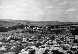
WJarash was a Palestinian village that was depopulated over the course of 1948 Arab-Israeli war. Located 25 kilometers west of Jerusalem, Jarash was a wholly Arab village of 220 inhabitants in 1948. The village was built of stone houses on the spur of a hill, 411 metres (1,348 ft) above sea-level, and lay about 1 km. eastward of the traffic circle opposite Moshav Zanoah, on regional road 3855 that bypasses Beit Shemesh to its east, and which road runs in a northerly-southerly direction along Wadi en Najil. The immediate region to the west of the site of Jarash, upon two hills separated by a valley, grew orchards belonging to the village inhabitants consisting of carobs, figs, almonds and olives. Cave dwellings dot the landscape of this region.
 W
WKasla was a Palestinian village in the Jerusalem Subdistrict. It was depopulated during the 1948 Arab–Israeli War on July 17, 1948 by the Harel Brigade of Operation Dani. It was located 17 km west of Jerusalem.
 W
WKhirbat al-'Umur was a Palestinian Arab village in the Jerusalem Subdistrict. It was depopulated during the 1948 Palestine war by the Har'el Brigade during Operation ha-Har. It was located 12 km west of Jerusalem on the Wadi al-Ghadir.
 W
WKhirbat Al-Lawz was a Palestinian Arab village in the Jerusalem Subdistrict. It was depopulated during the 1948 Arab-Israeli War on July 13, 1948 by the Har'el Brigade of Operation Dani. It was located 11 km west of Jerusalem, situated north of Wadi al-Sarar.
 W
WKhirbat al-Tannur, also known as Allar al-Sifla, was a Palestinian Arab hamlet in the Jerusalem Subdistrict, near Allar. It was depopulated during the 1948 Arab–Israeli War on October 21, 1948 under Operation Ha-Har. It was located 18.5 km west of Jerusalem.
 W
WKhirbat Ism Allah was a Palestinian Arab hamlet in the Jerusalem Subdistrict, located 26 km west of Jerusalem. It was depopulated during the 1948 Arab–Israeli War on July 17, 1948 by the Harel Brigade of Operation Dani. Khirbat Ism Allah was mostly destroyed with the exception of several deserted houses.
 W
WKhirbet et-Tibbâneh (Arabic: خربة التبانة), sometimes referred to by historical geographers as the Timnah of Judah, is a small ruin situated on a high ridge in the Judaean mountains, in the Sansan Nature Reserve, 622 metres (2,041 ft) above sea level, about 3 kilometers east of Aviezer and ca. 7 kilometers southeast of Bayt Nattif. The site is thought to have formerly borne the name Timnath, distinct from the Tel Batash-Timnah site associated with the biblical story of Samson in the lower foothills of Judea along the Sorek valley. Kh. et-Tibbaneh (Timnah) is perched upon a high mountain ridge rising up from the Elah valley and is where the episode of Judah and Tamar is thought to have taken place.
 W
WLavnin (Hebrew: חורבת לבנין)(Arabic: خربة تل البيضة), is a late Bronze Age archaeological site situated in Israel's Adullam region, rising some 389 metres (1,276 ft) above sea level. The site lies 8 kilometres (5.0 mi) northwest of Beit Gubrin, and about 1 kilometer west, north-west of Khirbat Umm Burj, directly south of Nehusha.
 W
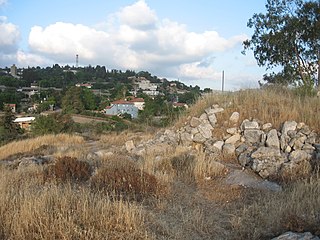
WMalha is a neighborhood in southwest Jerusalem, between Pat, Ramat Denya and Kiryat Hayovel in the Valley of Rephaim. Before 1948, Malha was a Palestinian Arab village known as al-Maliha. .
 W
WNitaf was a small Palestinian Arab village in the Jerusalem Subdistrict. It was depopulated during the 1947–1948 Civil War in Mandatory Palestine on April 15, 1948 during the second stage of Operation Dani. It was located 17 km west of Jerusalem, just north of Bayt Thul.
 W
WRas Abu 'Ammar was a Palestinian Arab village in the Jerusalem Subdistrict. It was depopulated during the 1948 Arab-Israeli War on October 21, 1948 by the Har'el Brigade of Operation ha-Har. It was located 14 km west of Jerusalem, surrounded on three sides by the Wadi al-Sarar.
 W
WSar'a, was a Palestinian Arab village located 25 km west of Jerusalem, depopulated in the 1948 war. The site today is recognized by historical geographers as the biblical Zorah / Zoreah, and lies on a hill, at an elevation of about 1,150 feet (350 m) above sea-level.
 W
WSaris was a Palestinian Arab village that was depopulated during the major offensive launched by the Haganah on 6 April 1948. Called Operation Nachshon, and launched before the British had left Palestine, its objective was to capture villages between Jerusalem and the coastal plain.
 W
WSataf was a Palestinian village in the Jerusalem Subdistrict depopulated during the 1948 Arab–Israeli War. It was located 10 km west of Jerusalem, with Sorek Valley bordering to the east.
 W
WSufla was a Palestinian Arab village in the Jerusalem Subdistrict. It was depopulated during the 1948 Arab–Israeli War on October 19, 1948 by the Sixth Battalion of the Harel Brigade under Operation Ha-Har. It was located 18.5 km west of Jerusalem.
 W
WThe Valley of Elah or Ella Valley is a long, shallow valley in Israel and the West Bank best known as the place described in the Old Testament where the Israelites were encamped when David fought Goliath. It is home to several important archaeological sites, including those identified as the ancient towns of Azekah and Socho (17:1). Rising up from the valley on its extreme southeast end lies the hilltop ruin Adullam, and on its north lie the ruins of the ancient fortress city of Khirbet Qeiyafa.
 W
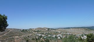
WAl-Walaja is a Palestinian village in the West Bank, four kilometers northwest of Bethlehem. It is an enclave in the Seam Zone, near the Green Line. Al-Walaja is partly under the jurisdiction of the Bethlehem Governorate and partly of the Jerusalem Municipality. According to the Palestinian Central Bureau of Statistics, the village had a population of 2,041 in 2007, mostly Muslims. It has been called 'the most beautiful village in Palestine'.
 W
W W
W W
W W
W W
W W
W W
W W
W W
W W
W W
W